Showing 2831 items
matching fences
-
 Glen Eira Historical Society
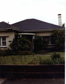
Photograph, Beauville Avenue, 3, Murrumbeena, 2001
Originally labelled "Beauville Estate, Established 1936, Still Thriving 65 years on, 10th March 2001", the Beauville Estate Album contains colour photographs of houses in the Estate. They were taken around the time of the Beauville Estate’s 65th Heritage Celebration held on 10/03/2001 and donated to the Caulfield Historical Society shortly afterwards. Photographer Bev Baxter. City of Glen Eira’s Heritage Management Plan Vol 2 p79 (this is p84 of the pdf version) – HO12 Beauville Estate and environs, Murrumbeena: The Beauville Historic Area is important at the State level as the first large housing estate undertaken by the AV Jennings Construction Co, later Jennings Group Limited, Victoria’s largest home builder. It is important also as a very early estate development incorporating a range of features other than houses and including made roads, shops and recreation facilities. In this respect it was the forerunner of the comprehensively planned housing estate of the post war era. The estate is distinguished by its aesthetic values, as is the earlier and comparable Hillcrest Estate, which are formed by a combination of restrained diversity in house styles, with the exception of no. 30 in the emerging International style, and by a landscaped garden environment. Colour photograph of cream coloured rendered house with unpainted brick features. Other features include a semi circular porch, tiled roof, chimney and a low unpainted brick fence in the foreground with small shrubs behind. A concrete path crosses the lawn to the porch.murrumbeena, houses, beauville avenue, architectural styles, 1930's, inter war style, a.v. jennings, av jennings, jennings, brick houses, beauville estate, sir albert victor jennings, a v jennings construction co, beauville estate heritage area, glen eira city council, architectural features, jennings group limited, land subdivision, gardens, beauville historic area, porches, chimneys, brick fences -
 Warrnambool and District Historical Society Inc.
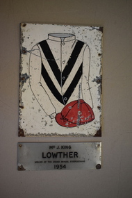
Plaque, Lowther, C 1990
These plaques were once on display at the Warrnambool racecourse with the smaller one originally affixed to a seat. These plaques commemorate the winner of the Grand Annual Steeplechase in Warrnambool in 1931. The Warrnambool Grand Annual Steeplechase was first held in June 1872. Today it is part of the Warrnambool May Racing Carnival and is run over 5,500 metres with 32 fences. Lowther won the race in 1954 after also winning the Brierly steeple on Tuesday These plaques are of interest as mementoes of the Warrnambool Grand Annual Steeplechase one of Australia's most significant hurdle races..1 A rectangular shaped metal plaque with ten perforations along the longer sides. The plaque has a sketch of a jockey's cap and silks with white sleeves and body with two black diagonal stripes. Red Cap. .2 Silver coloured metal plaque in a rectangular shape with four holes in each corner for attachment to a surface. There is black printing on the plaque..1 Lowther written in black texta on back of plaque. .2 Mrs J King Lowther Winner of the Grand Annual Steeplechase 1954.warrnambool, racing club, warrnambool grand annual steeplechase -
 Kew Historical Society Inc
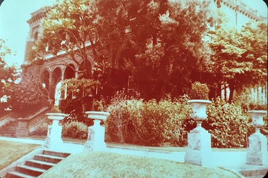
Photograph - 'Raheen', 96 Studley Park Road
Raheen was constructed as a two-storey house in the Italianate style with a four-storey tower over the entrance and single-storey extension. It was designed in an asymmetric and arcaded form, and is built of red brick with cement render. The property retains its garden layout, including an Italianate garden, outbuildings, fence and gates, and internal features including the original stairwell, library, ballroom and cast iron tower stairs. (source VHD)View of the upper and lower eastern loggias of 'Raheen' at 96 Studley Park Road, Kew from the eastern garden. The colour photo shows the pedestals and urns above the steps and the plantings in the garden c.1980. raheen -- 96 studley park road -- kew (vic.), historic houses -- studley park, mansions -- kew (vic.) -
 Melbourne Tram Museum
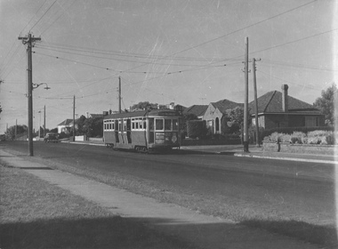
Photograph - L 102 Hawthorn Rd, East Brighton, Jim Seletto, January 1960
The photograph shows L class tram No. 102 with the destination City via Williams St route 65 in Hawthorn Rd, East Brighton. The tram is in the mid-distance and the road, span poles, street lights, residental houses with front fences are also included. Daylight with long shadows. The print is under exposed with several scratches in the centre requiring digital enhancement. Photo by Jim Seletto January 1960Shows 40 year old L class in revenue service as evidence of the MMTB's shortage of newer rolling stock.Black and white photgraph with photographer's notes on rearIn biro on rear: 'L 102 Hawthorn Rd East Brighton Jan 60 D X Print JSE7 J Seletto Phototrams, east brighton, hawthorn rd, tram 102, l class, span poles, tramways, route 65 -
 Melbourne Tram Museum
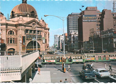
Postcard, Nucolorvue Publishing, "Melbourne The busy intersection of Swanston and Flinders Streets", late 1960s
Photo taken from the Flinders Gate Plaza looking west with the edge of the plaza podium fence in the view. In the view are Flinders St station, the SEC building and Young & Jacksons, which has an advertisement for Taubmans Paints. Two trams are crossing Flinders St, a wide-body tram with no marker lights, and W2 302. Based on the tram not being fitted with marker lights and the opening of the Plaza, photo late 1960s. Yields information about the intersection of Flinders and Swanston Streets.Colour postcard by Nu-Color-Vue No. ML 120, with serrated edges.postcards, swanston st, w2 class, flinders st, tram 302 -
 Ringwood and District Historical Society
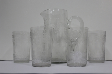
Domestic object - Jug and Glasses, Vintage glasses and pitcher set
Jug and four glasses, each item with hand etchings of Australian fauna and flora - kookaburra sitting on a post and rail fence; kangaroos; and tree ferns:; 1. Glass Jug with handle and spout.; 2-5. Glasses +Additional Keywords: O'Connor, Neville / O'Connor, Ian -
 Port of Echuca
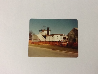
Colour Photograph, Aug 1980
The P. S. Adelaide was positioned in the Hopwood Gardens, Echuca as a static display whilst it was waiting to be fully repairedColour photograph of back port side of the P. S. Adelaide being restored on the western side of the Hopwood Garedens, Echuca, with orange fence around it and the side of a green wooden building at its right. The park sound shell is partially visible behind the boat to the right.On reserve in pen : Adelaide in Hopwood Gardens. In red pink : Print made by Kodak M. It's Kodak for color. Aug.80. Kodakp. s. adelaide, hopwood gardens, echuca, p. s. adelaide restoration -
 Federation University Historical Collection
Photograph, 4 Photographs of Painting of old Gaol Building
Old Gaol building is apart of the School of Mines Campus of Federation UniversityFour photographs of painters painting the old Gaol Building .1 3 painters in different positions doing painting .2 2 painters one on ladder painting around window .3 2 painters one standing on the fence .4 4 painters painting.painters, gaol building, school of mines ballarat, federation university, painting, painting gaol building -
 Glenelg Shire Council Cultural Collection
Photograph - Photograph - ANZ Bank, Portland, n.d
State Library of South Australia.Black and white photographic reproduction of earlier photograph. Depicting 2-storey bluestone building on a corner with door in left side, framed by double columns. Lamp on street corner and three figures (children ?) leaning against iron rail fence set in bluestone base.Front: A.N.Z. (Formerly Union) Bank. Cnr Percy & Julia Streets (typed label, top centre). Back: B21766/98 (pencil, upper left). State Library of South Australia Photographic Section. Order No. A16493 (stamp, centre).anz bank, commerce, banking, portland, bluestone building -
Glenelg Shire Council Cultural Collection
Photograph - Photograph - 'Kenley' House Percy Street Portland, c. 1970
Photographic print of a rephotographed photograph. Image shows front and one side of a single storey building. Fence and shrubs obscure some of the building. 'Kenley' residence of George Goodwin Crouch, first Portland Postmaster, next to Church of England, no. 37 Percy Street Portland. -
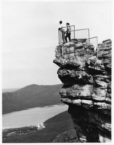 Halls Gap & Grampians Historical Society
Photograph - B/W
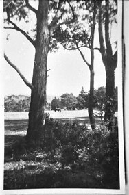
The two men are standing at The Pinnacle Lookout, overlooking Bellfield Reservoir in the Fyans ValleyTwo men standing behind cyclone wire three panel fence. Man on left is wearing a white shirt and long pants, the other in a checked shirt and long dark pants. They are on top of a large rocky outcrop overlooking a body of water and another mountain range scenery, lookouts -
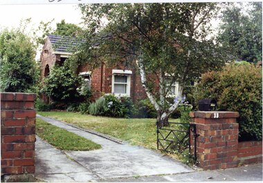 Glen Eira Historical Society
Photograph, Beauville Avenue, 33, Murrumbeena, 2001
Originally labelled "Beauville Estate, Established 1936, Still Thriving 65 years on, 10th March 2001", the Beauville Estate Album contains colour photographs of houses in the Estate. They were taken around the time of the Beauville Estate’s 65th Heritage Celebration held on 10/03/2001 and donated to the Caulfield Historical Society shortly afterwards. Photographer unknown.City of Glen Eira’s Heritage Management Plan Vol 2 p79 (this is p84 of the pdf version) – HO12 Beauville Estate and environs, Murrumbeena: The Beauville Historic Area is important at the State level as the first large housing estate undertaken by the AV Jennings Construction Co, later Jennings Group Limited, Victoria’s largest home builder. It is important also as a very early estate development incorporating a range of features other than houses and including made roads, shops and recreation facilities. In this respect it was the forerunner of the comprehensively planned housing estate of the post war era. The estate is distinguished by its aesthetic values, as is the earlier and comparable Hillcrest Estate, which are formed by a combination of restrained diversity in house styles, with the exception of no. 30 in the emerging International style, and by a landscaped garden environment. Colour photograph of unpainted variegated brown brick house with an arched porch, tiled roof, striped awnings, sash windows and low unpainted matching brick fence in the foreground with "33" on the brick pillar beside the driveway next to a low black cast iron gate. murrumbeena, houses, beauville avenue, architectural styles, 1930's, inter war style, a.v. jennings, av jennings, jennings, brick houses, beauville estate, porches, arches, sir albert victor jennings, a v jennings construction co, beauville estate heritage area, glen eira city council, architectural features, jennings group limited, land subdivision, gardens, beauville historic area, striped awnings, sash windows, brick walls, metal letterboxes, cast iron work -
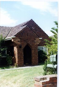 Glen Eira Historical Society
Photograph, Dalny Road, 11, Murrumbeena, 2001
Originally labelled "Beauville Estate, Established 1936, Still Thriving 65 years on, 10th March 2001", the Beauville Estate Album contains colour photographs of houses in the Estate. They were taken around the time of the Beauville Estate’s 65th Heritage Celebration held on 10/03/2001 and donated to the Caulfield Historical Society shortly afterwards. Photographer unknown. City of Glen Eira’s Heritage Management Plan Vol 2 p79 (this is p84 of the pdf version) – HO12 Beauville Estate and environs, Murrumbeena: The Beauville Historic Area is important at the State level as the first large housing estate undertaken by the AV Jennings Construction Co, later Jennings Group Limited, Victoria’s largest home builder. It is important also as a very early estate development incorporating a range of features other than houses and including made roads, shops and recreation facilities. In this respect it was the forerunner of the comprehensively planned housing estate of the post war era. The estate is distinguished by its aesthetic values, as is the earlier and comparable Hillcrest Estate, which are formed by a combination of restrained diversity in house styles, with the exception of no. 30 in the emerging International style, and by a landscaped garden environment. Colour photograph of an unpainted variegated brown brick house with decorative brickwork. Other features include tiled roof, enclosed porch with an arched entrance and black metal lantern, garden and a low unpainted brick fence in the foreground with a cast iron work letterbox on top.murrumbeena, houses, architectural styles, 1930's, inter war style, a.v. jennings, av jennings, jennings, brick houses, beauville estate, dalny road, porches, sir albert victor jennings, a v jennings construction co, beauville estate heritage area, glen eira city council, architectural features, jennings group limited, land subdivision, gardens, beauville historic area, brick features, brick fences, arches, cast iron work, letterboxes -
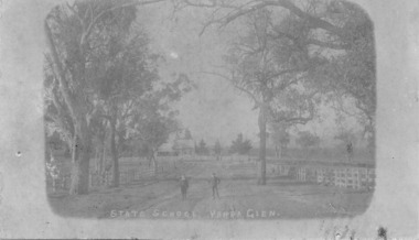 Yarra Glen & District Historical Society
Sepia postcards, State School Yarra Glen 19th century
Faded sepia photograph of the Yarra Glen State School taken from the School Lane (now called Yarraview Road). In the foreground are two schoolboys and three large trees. Post-and-rail fences are on either side of the road. In the distance is the school building on Symond Street.On the back at the top "POST CARD". Below that is "FOR CORRESPONDENCE" to the left and "FOR ADDRESS ONLY" to the right. Centre right is a stamp "YARRA GLEN/Mrs. E. Smith/SYMONDS STREET/YARRA GLEN 3775"yarra glen, post and rail fence, yarra flats, yarra glen state school, yarra glen primary school, symond street, school lane, yarraview road, schoolboys, school boys -
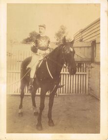 Bendigo Historical Society Inc.
Photograph - RANDALL COLLECTION: HORSE AND JOCKEY, July 1980
Photograph, Horse and Jockey with a Maltese cross on the chest and sleeves of the top that he is wearing, and white pants, black boots, and a Maltese cross on his cap. There are stables to the right and white picket fence behind the horse. On the back is; purchased from S.Hall, C.D.G.M.Bgo. July 1980.photograph -
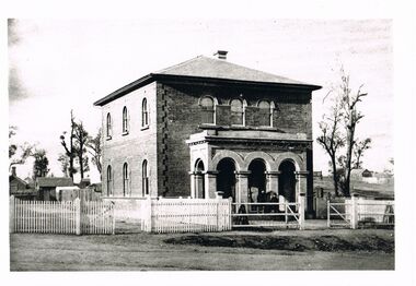 Bendigo Historical Society Inc.
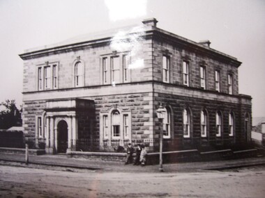
Photograph - WES HARRY COLLECTION: LAND OFFICE VIEW STREET
Black and white photo copy: image shows Survey office in View Street, known as Dudley House. Two storey brick building with verandah. Three arches in front portico facing street front. Picket fence on front of street, small buildings at rear.Batchelderplace, building, dudley house, bendigo, sandhurst, survey office, larritt, view street -
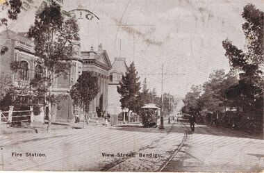 Bendigo Historical Society Inc.
Photograph - RANDALL COLLECTION: VIEW STREET, 1/6/06
Photograph, Peter Randall Collection, postcard photograph of View Street, Bendigo, also showing is the fence of Dudley House, Fire Station, the Capital Theatre, the ANA Building, all on the left side of the street, and a view of the tram lines down the street, and trees on either side.photograph, landscape, bendigo -
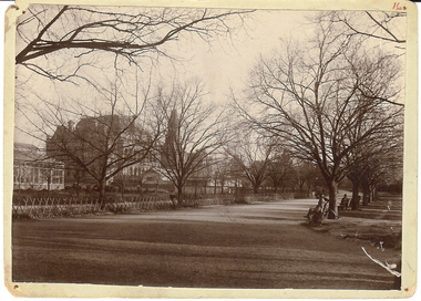 Bendigo Historical Society Inc.
Photograph - ROSALIND PARK: BENDIGO, 1930's ?
Black and white photo: Rosalind Park taken from corner of fernery looking toward rear of Law Courts and Post Office, showing conservatory on left. Bendigo Creek running behind trellis fence. Winter time. New police station not yet built.cottage, miners, ian wild, july 2000 'rosalind park taken from corner of the fernery, towards rear of law courts. conservatory on left. prior to building of police station. ' -
 Bendigo Historical Society Inc.
Photograph - HUSTLER'S ROYAL RESERVE GOLD MINE, ROSALIND PARK, BENDIGO
Black and white photo, copy. Image shows poppet head and chimney of Hustler's Royal Reserve Gold Mine, Rosalind Park, Bendigo. Oh RH side, Post Office building with clock tower. Horse drawn vehicles in foreground parked alongside fence.bendigo, mining, hustler's royal reserve mine -
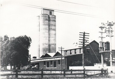 Bendigo Historical Society Inc.
Photograph - HARRY BIGGS COLLECTION: FINLEY FLOUR MILLS
Photograph of a factory building with a group of four large silos in the background, Two trucks are reversed into a loading bay at the front of the building. A post and railing fence runs across the foreground. On the front of the factory is a sign: Hutchinsons Finley Flour Milling and Agency Co. Pty Ltd.buildings, commercial, flour mill, finley flour mills -
 Bendigo Historical Society Inc.
Slide - BENDIGO VIEWS, Jun 1965
Slide. Bendigo Views. Unknown view of buildings with tall cone shaped roofs. The first and third buildings are gold and the second one is dark brown. Buildings at the back have dark red gable style roofs with white ridging. There is a stone fence along the front.slide, bendigo, bendigo views, bendigo views -
 Victorian Interpretive Projects Inc.
Photograph - Colour, Clare Gervasoni, Wanda Inn, Hepburn Springs, c1995, c1995
Wanda Inn was a highly regarded tea room during the 1920s and 1930s, when many people traveled to Hepburn Springs for their Honeymoon. It was destroyed by fire, along with Bellinzona Guest House, in November 2003. It was the second time Bellinzona had been destroyed by fire, the first time was in 1906 when a fire wiped out most of the township of Hepburn Springs.A colour digital image showing a picket fence, and a house in the background. The house is taken from Seventh Street and shows 'Wanda Inn' from 'Actea', (Church Avenue, Hepburn Springs) during a light snow fall. Wanda Inn was destroyed by fire in November 2003.hepburn springs, wanda inn, guest house, tea room. -
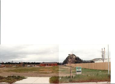 Hume City Civic Collection
Photograph, early 1990s
The series of 5 photographs feature different views of the Woodlands housing development which opened up land bounded by Gap and Anderson Roads, Cornish Street and Elizabeth Drive in the early 1990s. It was a large housing development built close to Sunbury township.A view of the northern boundary of the Woodlands housing development in Anderson Road. A paling fence divides the estate from the 'Malley' factory, now 'Storage King' which is on the corner of Cornish Street and Anderson Road. A 'For Sale' sign is in the foreground and a partly built house is in the middle distance.housing developments, anderson road, george evans collection -
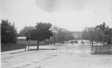 Stawell Historical Society Inc
Photograph, Lower Main Street Stawell looking East c1905. Merle Photographic Studio at Left
Lower Main Street looking East from Railway gates. Shows four horse drawn vehicles. The photo was taken from the railway gates towards the main shopping area. The Presbyterian spire can be seen in the back ground. c1905.Sepia Postcard of a street scene the roadway is central in picture featuring 4 horse drawn vehicles. Street is tree lined with picket fence on right side of photograph. 0007a taken opposite the Diamond house looking down Seaby St. toward the railway crossing.Lower Main Street Stawell No 10. is inscribed on the front and The "Merle Studio" Main Street, Stawell on the back.stawell shops business streetscape building transport -
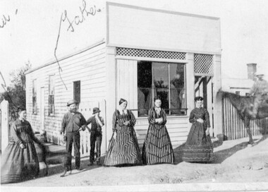 Stawell Historical Society Inc
Photograph, Mr John Bird & Mary Cocking -- possibly in front a Butcher Shop & Store
John Bird & Mary Cocking with five other people in front of a Store & what's said to be a butcher shop c 1874.Black and white photo of 7 people outside a weather board shop. Four of the group are females and two men one is on horseback and one a young boy. The women are in long decorative dresses. A house & chimney can be seen on the left side behind a picket fence. Handwritten on photo "Father" and part of "mother" (above squiggly line). The first two on left of photo.stawell business -
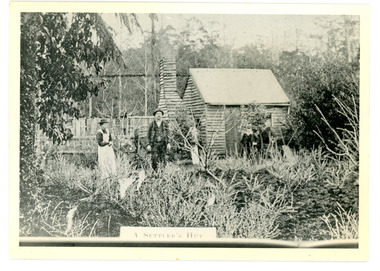 Mt Dandenong & District Historical Society Inc.
Photograph
The Keoghs took up Lot 7 in the Village Settlement in 1905. John Keogh was a big Irishman and cleared many of the giant trees on his Lot 7. They had little water for their crops so grew gooseberries and red currants rather than the more valuable strawberries. Mrs Keogh (nee Cleary) inherited money in 1906 and they built a new weatherboard house. The original bush hut remained as the kitchen. Son James (Jimmie) married Mary Walsh, a teacher at the local school. Jimmie built the small shop on the triangle of land cut off when the CRB road went through. Jimmie and his wife left the district when he joined Victoria Police. Jimmie came back to the area and finally sold the land of Lot 7 to Rimington's Nurseries. He moved his family to Kilsyth. In 1939 the shop was moved across the road to be used as an office by the road builders. It burned down that year.Black and white photograph of a man, woman and young male standing outside a wooden hut. There are crop remnants in the foreground and a wooden paling fence behind the hut. A label on the front reads A SETTLER'S HUT. Reverse of photograph has handwritten description by John Lundy-Clarke.Front: A SETTLER'S HUT Reverse: 1905 Keogh's hut on Falls Road then Main Road. This was later the kitchen of their extended home as described in the narrative "Mountain of Struggle". The figures are - Mrs Keogh. John Keogh settler. Son James Keogh.keogh, john keogh, james keogh, jimmie keogh, mary walsh, cleary, shop, store, gooseberries, rimington's nursery -
 Southern Sherbrooke Historical Society Inc.
Photograph - Trees and horse at golf course
Photograph of a paddock at the golf course, Lockwood House. Between the trees in the foreground, a horse can be seen grazing in the distance. A wire fence can be seen in front of some trees on the right side. Probably taken by Betty de Coite nee Woods or her parents. -
 Southern Sherbrooke Historical Society Inc.
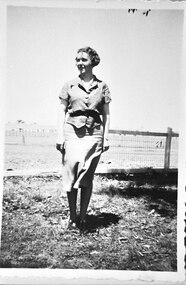
Photograph, Ethel Breen nee Prince
B&W photo of Ethel Breen nee Prince. Ethel stands near a wire fence with paddocks behind her. She is wearing a linen suit, short-sleeved and belted. Her hair is ear-length and she is looking off to the left side of the photo. -
 Ballarat Tramway Museum
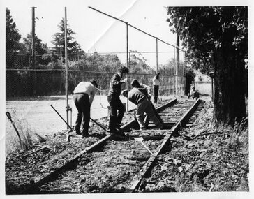
Photograph - Black & White Photograph/s, Paul Nicholson, c1972
Yields information about the SEC depot and the BTPS volunteers dismantling track in the depot.Black and white photograph of the dismantling of "0" road at the SEC depot, by BTPS volunteers, c1972. SEC depot Tennis court fence in photo. Photographed by Paul Nicholson. Has BTPS address stamp on rear. See also Reg Item 6278 for similar photograph.In pencil "Paul Nicholson" and "BTPS" address stamp in purple ink and 1) in pen in the top right hand corner.tramways, trams, btps, depot -
 Surrey Hills Historical Society Collection
Photograph, Streetscape near the corner of Victoria Crescent and Hotham Street, Surrey Hills
Prior to subdivision for housing this area was paddocks used for grazing of cattle and used as part of the course in the early days of the Surrey Hills Golf Club. Reproduced by permission of Mr John Arnold from his book: "The Riversdale Golf Club - a history, 1892-1977." Copyright to book: Riversdale Golf Club. Surrey Hills Golf Club operated from 1892-1908 then moved and became Riversdale Golf Club. The game was played across paddocks from Trafalgar Street, Mont Albert to Whitehorse Road and down Victoria Crescent to where Box Hill TAFE is now located in Elgar Road. There were problems with cows eating the tee flags! The clubhouse still exists as 30 Trafalgar Street.Black and white photo taken from the centre of a bitumen road which is flanked by bluestone guttering. Nature strips, drive cross-overs and house fences are shown. Trees on the RHS nature strip are pollarded to avoid overhead power and telephone lines. There houses in the background."Bottom: The same view today taken from the intersection of Victoria Crescent and Hotham Street, Surrey Hills."surrey hills golf club, hotham street, victoria crescent, riversdale golf club, surrey hills, john arnold