Showing 5619 items
matching george street
-
 Hume City Civic Collection
Photograph, Early 1980's
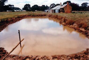
The mud brick cottage and outbuilding was possibly built by James Waylett in the 1850's and it is only one of three remaining mud brick buildings in the Oaklands-Greenvale which were constructed in the late 19th Century.A coloured photograph of farm scene. A dam is in the foreground and the remains of a mud brick cottage and timber and corrugated building in the middle distance. Further farm buildings can be seen in the distance.mud brick buildings, waylett, james, farm buildings, sherwood, somerton road, oaklands hunt club, george evans collection -
 Hume City Civic Collection
Photograph, Late 1980's
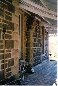
'Dunhelen' is situated on the Mickleham Road at Greenvale. The rear of the homestead was constructed in the 1850's and the original owners were Richard and George Sinclair Brodie who emigrated from Scotland.A coloured photograph of part of a porchway of a house. The verandah roof is constructed from wooden beams and corrugated iron. The walls are bluestone with granite stone quions around the corners and window frames. The verandah was paved with stone pavers done in a diamond pattern.dunhelen, brodie, george sinclair, richard sinclair, george evans collection -
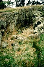
 Hume City Civic Collection
Photograph
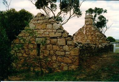
The ruined granite building is part of the Glen Loeman estate at Bulla. It is aboaut 7 x 4m and was probably a single room. It has been roughly constructed from roughly worked granite blocks and rubble stone laid unevenly.A coloured photograph of the ruins of a granite building. The end walls and chimney are left standing as is part of the side wall.granite, burns, joseph, loeman, michael, isabella, glen, george evans collection -
 Hume City Civic Collection
Photograph, Late 1980's
The Millbrook ruins are on a property which was created by John Pascoe Fawkner's Victoria Co-operative Freehold Land Investment Society. The aims of the company were to provide smallholdings to poorer settlers who wanted to farm. The ruins are now part of the Organ Pipes Park.A coloured photograph of stone ruins built on a hillside with sheoaks and other vegetation behind it. There is a doorway at the end of the small building.fawkner, john pascoe, millbrook ruin, jacksons creek, organ pipes park, victorian co-operative freehold land investment society, george evans collection -
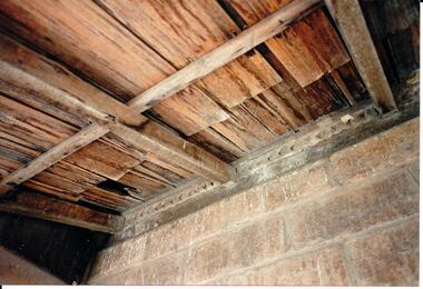 Hume City Civic Collection
Photograph, Late 1980's
The wooden shingle roof is part of the roof of Waylett's Cottage at Greenvale in Somerton Road.A coloured photograph of the wooden ceiling and stone walls of part of a building.shingle roofs, mud brick cottages, waylett, james, farm buildings, george evans collection -
 Hume City Civic Collection
Photograph, Early 1990's
This is a photograph of one of the many stone ruins which can be seen in the Sunbury area and surrounding districts. These ruins are found in varying degrees of structural damage caused by erosion, vegetation growth and vandalism. This is the remains of a bluestone quarry on the 'Oaklands' property at Oaklands Junction.A coloured photograph in portrait format of a basalt rock ruined structure which has been dug into a hillside with a line of trees in the background.stone structures, oaklands quarry, george evans collection -
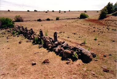 Hume City Civic Collection
Photograph, Early 1990's
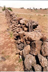
This is a photograph of one of the many stone ruins which can be seen in the Sunbury area and surrounding districts. These ruins are found in varying degrees of structural damage caused by erosion, vegetation growth and vandalism. The remains of the post and stone fence can be seen near Emu Creek at Bulla.A coloured photograph of the remains of a low post and stone fence in a sunburnt paddock. There are a few low growing bushes dotted across the paddocks.stone structures, dry stone walls, post and stone fences, george evans collection -
 Hume City Civic Collection
Photograph, Early 1990's
This is a photograph of one of the many stone ruins which can be seen in the Sunbury area and surrounding districts. These ruins are found in varying degrees of structural damage caused by erosion, vegetation growth and vandalism. The adit and mullock heap is from one of the mines on Redstone Hill. It was known as Batey's Mine.A coloured photograph of the remains of a mullock heap and adit from a mine. The entrance is surrounded by low growing trees and grass.stone structures, batey's mine, gold mining, redstone hill, george evans collection -
 Hume City Civic Collection
Photograph, Early 1990's
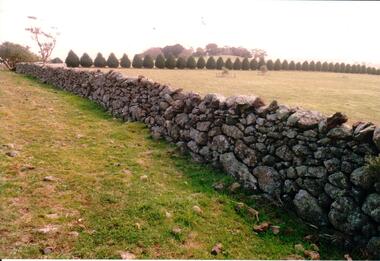
This is a photograph of one of the many stone ruins which can be seen in the Sunbury area and surrounding districts. These ruins are found in varying degrees of structural damage caused by erosion, vegetation growth and vandalism. The dry stone wall is at Crowes Hill at Yuroke.A coloured photograph of a dry stone wall with a row of shaped cypress trees running off at right angles to the fence. A small tree covered hill is in the distance.stone structures, dry stone walls, crowes hill, george evans collection -
 Hume City Civic Collection
Photograph, Early 1990's
This is a photograph of one of the many stone ruins which can be seen in the Sunbury area and surrounding districts. These ruins are found in varying degrees of structural damage caused by erosion, vegetation growth and vandalism. The post and stone fence at Emu Creek at Bulla is more intact in this photograph.A coloured photograph of a post and stone fence surrounded by sun drenched paddocks.stone structures, post and stone fences, emu creek, george evans collection -
 Hume City Civic Collection
Photograph
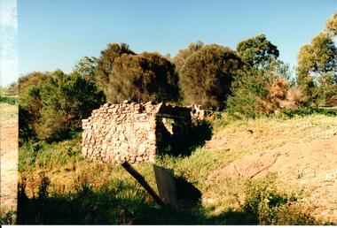
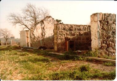
This is a photograph of one of the many stone ruins of buildings which can be seen in the Sunbury district and surrounding areas. This series of 13 photographs show various views of one of the remaining uninhabited stone cottages which were built in the early days of the district's settlement.A coloured photograph of the ruins of a stone cottage. The walls are still standing and the end wall bears evidence of the original pitched roof. There is a cleared area in front of the ruins.stone structures, shingle roofs, george evans collection -
 Hume City Civic Collection
Photograph, Unknown
A coloured photograph of a new housing development. There is a low metal and wire fence across the foreground and an open area immediately beyond the fence. Some housing development is evident amongst the gum trees which are across the middle distance.housing developments, george evans collection -
 Hume City Civic Collection
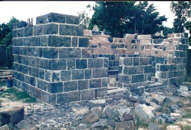
Photograph, 1993
The Aitkens Gap Gaol was removed from its original site at Gap Village on the Calder Highway and relocated in front of the Sunbury Police Station in 1993.A coloured photograph of the resiting and rebuilding of the Aitken Gap Gaol outside the Police Station in Sunbury. The two end walls have been constructed as far as the windows and work has commenced on the front and back walls. Some stones are scattered around the site.peter free, aitkens gap gaol, sunbury police station, police historical association, george evans collection -
 Hume City Civic Collection
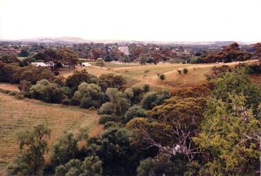
Photograph, c 1980s
The photograph although recently taken shows the original settled area in Sunbury, which included Goonawarra Vineyard and Macedon Street which was once the business centre of Sunbury township before the railway was established.A coloured photograph of Sunbury Township looking west from above Jacksons Creek and Goonawarra Winery. Macedon Street can be seen in the middle distance and Mt. Holden and Burke Hill are across the skyline.sunbury township, mt. holden, burke hill, francis, james goodall, barnier, john, jacksons creek, goonawarra winery, george evans collection -
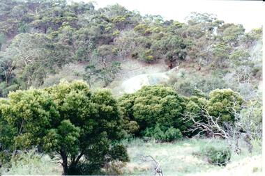
 Hume City Civic Collection
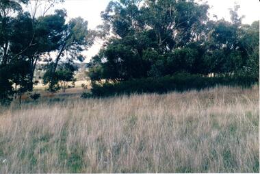
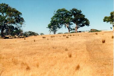
Photograph
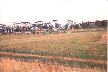
A coloured photograph of the grassland and scrub land which is situated north of Rupertswood.grassland, rupertswood estate, george evans collection -
 Hume City Civic Collection
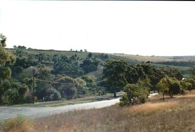
Photograph, c late 1980s
The photograph shows a section of the original settlement of the Bulla township. The cutting on the hillside is significant as it is the remains of one of the original stream crossings in Victoria.A coloured photograph of the Bulla Hill along Sunbury Road with a view of the cutting on the distant hillside. The photograph is a view of the old Bulla township looking to the NW. There is a wide grassy verge in the foreground.bulla township, deep creek, wright, william 'tulip', sunbury road, george evans collection -
 Hume City Civic Collection
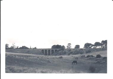
Photograph, pre 1970
The five arch bridge spans Blind Creek in Sunbury. The bridge is at the start of one of the longest and steepest inclines on a railway track in Australia.A black and white photograph of the 5 arch railway bridge and surrounding open area near Rupertswood. The tower of Ruppertswood can be seen in the distance.railway bridges, rupertswood, bridges, george evans collection -
 Hume City Civic Collection
Photograph, c late 1990s
The series of 9 photographs were taken to be included in a study of archaeological sites and Aboriginal rings in the Sunbury area. Five earth rings which are thought to be associated with male initiation ceremonies have been identified in Sunbury. Only 3 others have been found in the rest of Victoria. Despite rapid development in the area, those sites are protected heritage sites.A coloured photograph of an open hillside which is a sacred site. Gum trees and grassy tufts are dotted across the hillside.aboriginal culture, aboriginal rings, sacred sites, george evans collection -
 Hume City Civic Collection
Photograph, c late 1990s
The series of 9 photographs were taken to be included in a study of archaeological sites and Aboriginal rings in the Sunbury area. Five earth rings which are thought to be associated with male initiation ceremonies have been identified in Sunbury. Only 3 others have been found in the rest of Victoria. Despite rapid development in the area, those sites are protected heritage sites.A view of the Aboriginal ring and sacred site and its close proximity to a proposed housing estate at Sherwood near Racecourse Road.aboriginal culture, aboriginal rings, sacred sites, george evans collection -
 Hume City Civic Collection
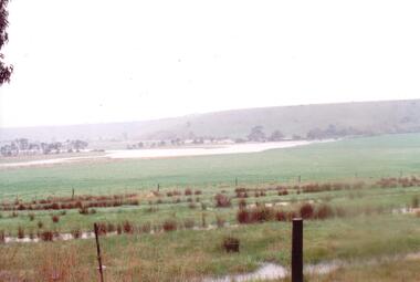
Photograph
The series of photographs were taken after exceptional heavy rain had fallen in Sunbury in the early 1990s. The Jackson Creek overflowed its banks and the surrounding flood plain area was under water.A coloured photograph of the Jackson Creek in flood along a river flat within the Rupertswood Estate. There are bare hills in the background and a fenced off run in the foreground.floods, weather patterns, jacksons creek, george evans collection -
 Hume City Civic Collection
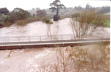
Photograph
The series of photographs were taken after exceptional heavy rain had fallen in Sunbury in the early 1990s. Jackson's Creek overflowed its banks and the surrounding flood plain area was under water.A coloured photograph of Jackson's Creek in flood taken near the footbridge in Macedon Street. The Nook area and Goonawarra Vineyard are in the background.floods, weather patterns, jacksons creek, george evans collection -
 Hume City Civic Collection
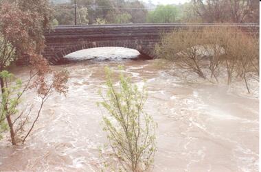
Photograph
The series of photographs were taken after exceptional heavy rain had fallen in Sunbury in the early 1990s. Jackson's Creek overflowed its banks and the surrounding flood plain area was under water.A coloured photograph of Jackson's Creek in flood. The floodwaters have almost reached the top of the arch of the Macedon Street stone bridge.floods, weather patterns, jacksons creek, george evans collection -
 Hume City Civic Collection
Photograph, c 1980s
... . stone bridges jacksons creek macedon street road bridge george ...The stone bridge was the only entry into Sunbury on the eastern side of the town and was in use until the road was re-routed and widened in the 1970s.A coloured photograph of the roadway over the Macedon Street bridge which spans Jacksons Creek. There is a grassy area in the foreground with trees growing either side of the bridge. The narrow asphalted surface of the road across the bridge is cut off by a low stone wall.stone bridges, jacksons creek, macedon street road bridge, george evans collection -
 Hume City Civic Collection
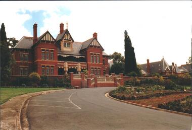
Photograph, mid 1980s
The building in the photograph was the main administrative building of the former Sunbury Asylum which was closed down in 1991. The buildings are now part of the Sunbury campus of the Victoria University of Technology.A coloured photograph taken from the eastern side of the curved approach to the main entrance of the former Sunbury Asylum. The photograph shows the two front wings and attic of the main administrative building and other buildings beyond the main building.sunbury asylum, victoria university of technology, george evans collection -
 Hume City Civic Collection
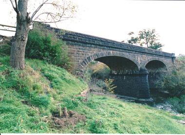
Photograph, late 1980s
The road bridge over Jackson's Creek in Sunbury was built in 1870 and was in use until a wider bridge was built when Sunbury Road was rebuilt in the early 1970s.A coloured photograph taken from the NE side of the river bank of a complete view of the bluestone bridge at Macedon Street. The two eliptical arches and the protruding pylon as well as the underside of the bluestone span are clearly visible.transport, roads and bridges, jacksons creek, harris, thomas lascelles, george evans collection -
 Hume City Civic Collection
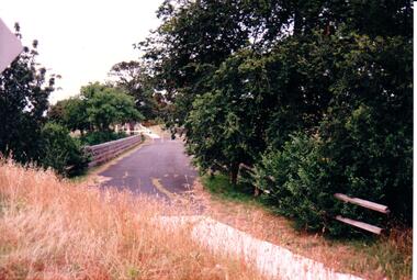
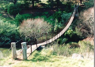
Photograph, 1980s
The timber and cable swing bridge straddled the Deep Creek at Bulla behind the Bulla school. It enabled children who lived across the river to travel directly to school instead of going the long way around the road, a possible distance of 2-3 kms.A coloured photograph of the timber and cable swing bridge which was constructed across the Deep Creek at Bulla. Trees are growing along the river bank and there is a row of conifers growing along the opposite bank.swing bridges, deep creek, george evans collection -
 Hume City Civic Collection
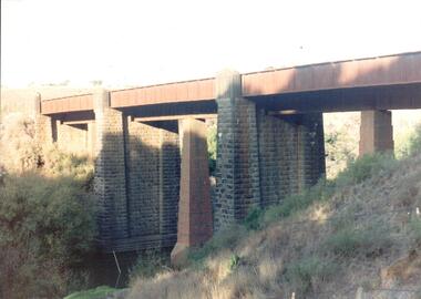
Photograph, late 1990s
The bridge constructed from bluestone, brick and iron over the Jacksons Creek at Sunbury is an important structure on the Melbourne-Echuca rail line. The foundation stone for the bridge was laid on 13 January 1859 and the bridge opened in July 1861. It is of state significance.A coloured photograph of the bluestone and iron railway bridge which is ove the Jacksons Creek. The bridge has 3 bluestone pylons and three iron pylons with 3 sections of the iron spans visible across the top.transport, bridges, rail transport, darbyshire, g. c., jacksons creek, george evans collection -
 Hume City Civic Collection
Photograph, 1980s
This is possibly a photograph which records trips made around Victoria of the 'Flying Scotsman' engine which was brought to Australia in late 1980s.A coloured photograph of a steam engine painted blue, black and red travelling under full steam along a rail track.steam engines, the flying scotsman, railways, george evans collection -
 Hume City Civic Collection
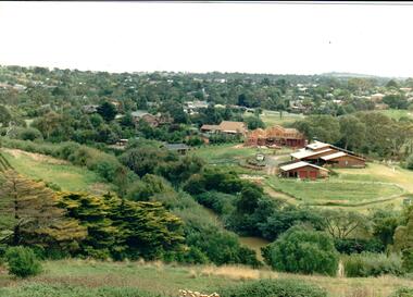
Photograph
Housing development spread to the banks of the Jacksons Creek at the east end of the town in the late 1970s.A coloured landscape photograph overlooking the Jacksons Creek and Sunbury township and showing housing development which is taking place on the horse shore bend also known as blueberry island on the opposite creek bank.jacksons creek, blueberry island, george evans collection -
 Hume City Civic Collection
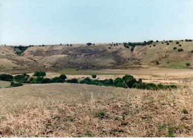
Photograph, c 1990s
Canon Gully is situated about 2 km upstream from the railway bridge at Rupertswood. In 1864 it was the site for the military encampment of the Victorian Volunteer Forces. William Clarke allowed the military to stage the annual event on his property. Further encampments were held on this site in 1874 and 1877.A coloured photograph of a wide valley with cleared hills in the background. The tree lined creek or watercourse is across the middle distance of the image.canon gully, rupertswood estate, encampments, clarke, william j. t. 'big bull', victorian volunteer forces, george evans collection