Showing 11556 items matching "maps"
-
 Bendigo Historical Society Inc.
Map - GOORNONG, 29/04/1879
Map: Parish of Goornong, County of Bendigo. Parish plan (coloured) (number 326 in map cupboard 1)map, bendigo, parish plan, goornong -
 National Vietnam Veterans Museum (NVVM)
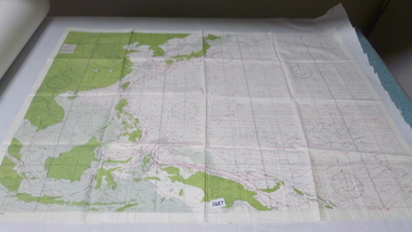
Map, Map Cloth
Cloth map of Western Pacific region noting countries and water currents around. map is double sidedmap -
Koorie Heritage Trust
Book, Beauglehole, A. C. & H. M, The distribution and conservation of vascular plants in the north east area, Victoria, 1988
ii, 98 p. : ill., maps ; 21 x 30 cm. + 1 folded col. map.botany -- victoria, northeastern. -
Koorie Heritage Trust
Book, Beauglehole, A. C, The distribution and conservation of vascular plants in the north central area, Victoria, 1982
iv, 102 p. : ill., maps ; 22 x 30 cm. + 1 col. folded map.indigenous vascular plants. distribution. northern victoria | botany -- victoria. -
 Ballarat Heritage Services
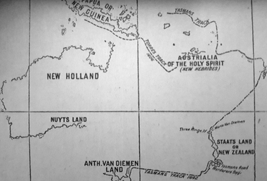
Photograph - Map, A Sketch from Dalyrmples Map of 1767, 1767
Copy of a map showing the coast that was known during the voyge of the Endeavour, and the first map that marks Torres track.map, new holland, hollandia nova, isaac de graaff, new guinea, australia of the holy spirit, papua, new hebrides, new zealand, nuyts land, van dieman's land, tasman's track, torres -
 Bendigo Historical Society Inc.
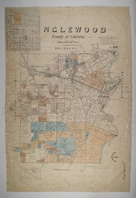
Map - INGLEWOOD, 17/12/1877
Map: Parish of Inglewood, County of Gladstone. Parish plan. Earliest date on map 31/12/75.map, gladstone, parish plan, inglewood -
 Kiewa Valley Historical Society
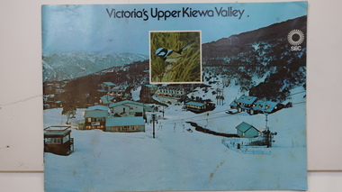
Booklet - SEC x2, 1. Victoria's Kiewa Valley 2. Victoria's Upper Kiewa Valley, No. 2 is dated October 1978
The State Electricity Commission of Victoria built the Kiewa Hydro Electric Scheme and was keen to promote tourism in the area. The booklet includes Facilities, Falls Creek Ski Resort, the Kiewa Works Area, the Three Floras of Bogong, the Geology of the Kiewa area, the Bird and Animal life of Bogong and the Kiewa Hydro Electric Scheme. The colored photos and the map on the back appeal to the reader/tourist.The SECV promoted tourism in the Kiewa Valley especially the area of the Kiewa Hydro Electric Scheme. This booklet is attractive and informative with a lot of detail. This proved to be the early stages of tourism in the area in what is now a very popular tourist destination and the main industry for the Upper Kiewa Valley.Blue cover with photo of Falls Creek at night. Title in black print at the centre top under which is an insert photo of a blue wren and SEC logo in white towards the top far right. Back cover is light green with a tourist map of the area. The text is complimented with brightly colored photos throughout.state electricity commission of victoria; kiewa hydro electric scheme; tourism; bogong; flora; fauna; geology; -
 Bendigo Military Museum
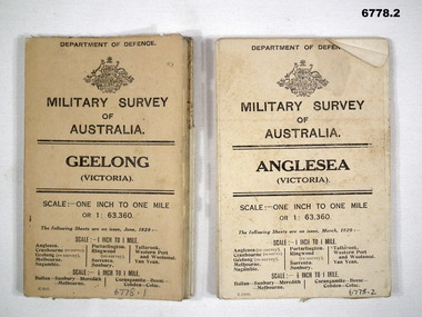
Map - MAPS, GEELONG & ANGLESEA, 1928 - 1929
J.W. Swatton, Refer to Cat 6719.2P1. Military Survey map of Australia - Geelong, Vic. One inch to One mile - the map is in colour print. The two outer covers are cardboard, the map then opens up in a multifold manner. Date June 1928 2. Military Survey map of Australia - Anglesea, Vic. One inch to one mile - the map is in colour print. The two outer covers are cardboard. The map then opens up in a multi fold manner. Date March 1929.anglesea, military survey maps, geelong, victoria, passchendaele barracks trust -
 Shepparton RSL Sub Branch
Box, c. 1921
According to the Australian War Memorial, "The Red Cross maintained a policy of ensuring that comfort and entertainment for the wounded in hospital was onging and stated in its Gazette of December 1917 'Wherever they are, our boys will have a reminder on Christmas Day that the thoughts and sympathy of their people in far-off Australia are with them.' The boxes were usually packed in Australia and contained 'a pipe, tobacco, cigarettes, chocolate, playing cards, match-box, handkerchief and an attractive card, Australian in nature, conveying greetings from the Society.' (Gazette no 7, January 1918)." This particular example dates to 1921, after the war had ended. It is apparent that the efforts of the Red Cross extended beyond wartime years, possibly to those still stationed overseas or returned servicemen and women.This box is an example of charitable gift boxes which were delivered to Australian troops during the war by the Australian Red Cross Society.Wood imitation printed card box in two parts, rectangular in shape fashioned from two pieces of card folded and stapled on shorter sides. Larger box (lid) fits on top of smaller box (base). Top of box has adhesive label with printed inscriptions, gold on light coloured label."GREETINGS/from/The/Australian/Red Cross/Society" a map of Australia with the states identified and capital cities "Perth", "Darwin", "Brisbane", "Sydney", "Melbourne", "Hobart", "Adelaide". To right of the map "Xmas/1921"christmas, holiday, gift giving, red cross, red cross society, returned servicemen, veterans, post war, world war i, first world war, the great war -
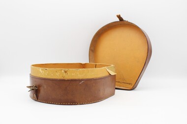
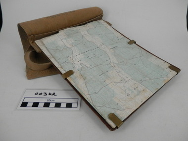 Frankston RSL Sub Branch
Map Case
Standard Australian Army webbing map case with shoulder strap. This map case is complete with a folded Australian Survey map of Puckapunyal, Victoria produced in 1988. Inscription BHG Ltd 1945 -
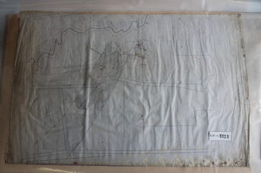 Coal Creek Community Park & Museum
Mine Map
8518.1 - Unlabelled map of mining tunnels, coal seams, boreholes, creeks, roads and (presumably) paddock boundaries. Based on features in common with other maps, very likely map of Korumburra area. -
Bendigo Historical Society Inc.
Map - VICTORIA, Circa 1926
Map: Map showing Counties, including Railway lines and Geographic features. Compiled and engraved at the Department of Lands and Survey Melbourne, Revised October 1926 ( number 184 in Map Cupboard 1)map, victoria, counties, counties of victoria, geographic features -
 Melbourne Tram Museum
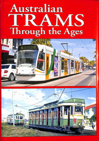
Book, Maurice Kelly, "Australian Trams Through the Ages", 2015
... Maps ...Book, hard bound with photo jacket, 320 pages, sewn binding with glued end papers, printed on gloss paper, titled "Australian Trams Through the Ages", compiled by Maurice Kelly of Topmill Pty Ltd. Limited Edition - number 340 of 1000. Published 2015, has a table of contents listing photos of 22 tramway systems, including Gold Coast light rail, Museums horse trams, include some light railways such as Aramac. The Melbourne section includes Doncaster, horse trams, cable trams, electric trams, a maps c1950 and 1956, 1981 and PTV map of July 2014. many electric trams, generally photos by Arthur Perry, including an E class tram. Features tram 5012 on front cover.trams, tramways, topmill, maps, melbourne, cable trams, horse trams, mmtb, melbourne, ptc -
 Bendigo Military Museum
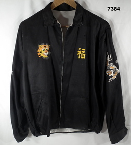
Souvenir - JACKET, Handmade in Vietnam, c1969
Item in a collection relating to Wes Bertuch, refer Cat No 1664.2 Jacket - bespoke handmade, in black cotton fabric exterior and white silk fabric lining. With collar, long sleeves, cuffs with black plastic buttons, inset pockets and elasticised area on waist band. Front zipper closure. Handstitched decoration on front, top of sleeves and back of jacket. Front - left side, yellow cotton? Vietnamese writing, Right side - yellow, orange, white and brown cotton - face of a tiger. Top of sleeves - left and right - orange and white cotton - dragons. Back of jacket - blue, orange, green and yellow map of Vietnam, Laos and Cambodia.On Jacket back - handstitched in yellow cotton "WHEN I DIE I'LL GO TO HEAVEN/ BECAUSE/ I'VE SPENT MY TIME IN HELL/ VIET & NAM/ 68 69". On and beside map - hand stitched in white cotton "LOVIS/ HANOI/ THAILAND HUE/ DA-NANG/ QLV-NI-ION/ BANGKOK NHA- TRANG/CAM-RANH/PHAN THIET/ BIEN HOA/ . On map - yellow cotton "CAMBODIA/SAIGON"souvenir, vietnam, clothing -
 Bendigo Historical Society Inc.
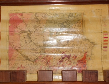
Map - MARKS COLLECTION: GEOLOGICAL MAP OF IRELAND
Rolled map on wooden hanger, wooden rail on bottom. On top of map: 'geological survey of Ireland' On bottom LH side: the geology of this map published June 1855 by Sir R.I. Murchison, Director General, J. Beebe Jukes Local Director, surveyed by T. Oldham. Map part of Lansell material. On back of map at top written in black pen 'Ireland'.person, bendigo, george lansell -
 Bacchus Marsh & District Historical Society
Map, Gorrockburkchap Parish Map, County of Grant c.1906
The parish of Gorrockburkchap (sometimes spelled Gorrockburkghap) lies to the west and south west of the township of Bacchus Marsh. The locality of Rowsley is situated within this parish area.A single page paper map showing the parish plan for Gorrockburkchap in the County of Grant. A cadastral map showing parish boundaries and land ownership The map is pasted into a bound volume containing 76 maps or plans in total. High resolution digital image stored on BMDHS computer network. gorrockburkchap parish maps, rowsley victoria maps, bacchus marsh region parish plans -
 Ringwood and District Historical Society
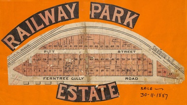
Flyer, Subdivision sale poster - Railway Park Estate, Ringwood, Victoria - 1887
Collage of clipped lettering and map pasted to orange coloured card depicting Railway Park Estate subdivision sale. Handwritten names associated with allotments and notation of sale date - 30 November, 1887. Subdivision plan with pink shading highlighting 73 allotments in Ferntree Gully Road (later Bedford Road) and Pitt Street, Ringwood. Handwritten names associated with allotments include Arthur Wiseman, T. Grant, J.J. Miller, M. Dickson, G.G. Miller, J. Frost, J.K. Turnbul, J.W. Davis, William Aldridge. Additional hand-drawn map on cardboard backing labeled Allotments for Sale at Ringwood - Part of Crown Allotment 17. -
 Ballarat Tramway Museum
Magazine - Electric Traction article, Keith Kings, After Geelong What?" and "Farewell to Geelong", March 1956
Editorial written at the time of the start of the closure of many Australian tramway systems, asking what is the next tramway system to close. The other two Victorian Provincial Tramway systems were considered safe at the time, however under constant threat of closure by the SEC due to the losses that were being incurred. Written by well-known Victorian tramway historian Keith Kings. The article with maps and photos details the history of the Geelong tramway system.Details the history of the Geelong Tramway system and gives details of the tramcars that were used on the system.Photocopy of an item from the Electric Traction Magazine March 1956 about the closure of the Geelong Tramway System, and trimmed to the magazine original size - 12 sheets stapled. Includes Maps and photographs. Text written by Keith Kings. Article interspersed with materials about the Adelaide Tramway system.geelong trams, closure, tramways, tramcars -
Glenelg Shire Council Cultural Collection
Map - Map - Glenelg River, 1975
Laminated map, Glenelg River - Casterton, proposed flood level and lines to be designated. Photograph of map taken in 1975. Produced by Rural Water Commission to Shire Engineer, Casterton, attached to reverse of map.flood, flood levels, casterton -
 City of Moorabbin Historical Society (Operating the Box Cottage Museum)
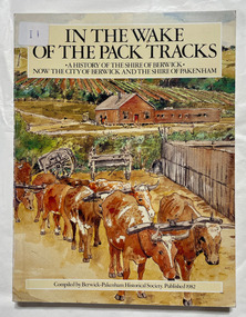
Book, Berwick-Pakenham Historical Society, In the wake of the pack tracks : a history of the Shire of Berwick, now the City of Berwick and the Shire of Pakenham, 1982
A history of the Shire of Berwick, now the City of Berwick and the Shire of Pakenham.xvi, 175 p. : ill., maps (some col.), ports. ; Includes index. eCol. maps on lining papers.non-fictionA history of the Shire of Berwick, now the City of Berwick and the Shire of Pakenham.berwick, pakenham -
Bendigo Historical Society Inc.
Map - KANGAROO FLAT SUBDIVISION, 26/11/1900
Map: Plan of Subdivision at Kangaroo flat, Parish of Sandhurst, County of Bendigo ( number 149 in Map Cupboard 1)map, bendigo, parish plan, kangaroo flat, parish of sandhurst, county of bendigo -
Bendigo Historical Society Inc.
Map - PLAN OF THE TOWNSHIP OF SANDHURST(PHOTOCOPY)
Map: Photocopy of a plan of the Township of Sandhurst. Dated 26 July 1854 ( number 141 in Map Cupboard 1)map, bendigo, city streets, township of sandhurst, early bendigo, city streets -
Bendigo Historical Society Inc.
Map - NERRING, 15/06/1937
Map: Parish of Nerring, County of Bendigo. Parish plan Canvas backed ( number 139 in Map Cupboard 1)map, bendigo, rural, nerring, county of bendigo -
Bendigo Historical Society Inc.
Map - PARISH OF SANDHURST SHEET 5A, 1970
Map: Parish of Sandhurst Sheet 5A, County of Bendigo. Parish plan ( number 161 in Map Cupboard 1)map, bendigo, parish plan, parish of sandhurst, county of bendigo -
Bendigo Historical Society Inc.
Map - EAGLEHAWK (PART), 22/01/1882
Map: Parish plan showing area Eastward from Lightning Hill ( number 205 in Map Cupboard 1)map, bendigo, parish plan, eaglehawk, lightning hill -
Bendigo Historical Society Inc.
Map - NERRING. SHEET ?, Circa 1894
Map: Nerring, Part ( number unreadable), County of Bendigo. Parish plan ( number 190 in Map Cupboard 1)map, bendigo, parish plan, nerring -
Bendigo Historical Society Inc.
Map - RAYWOOD, 18/09/1930
Map: Township of Raywood, Parish of Neilborough,County of Bendigo. Parish plan (number 270 in map cupboard 1)map, bendigo, township, raywood -
Bendigo Historical Society Inc.
Map - GOORNONG, 1/10/1906
Map: Town of Goornong, Parish of Goornong, County of Bendigo. Parish plan (number 269 in map cupboard 1)map, bendigo, township, goornong -
Bendigo Historical Society Inc.
Map - RAVENSWOOD, April 6th 1872
Map: Township of Ravenswood. Parish plan, has a 1913 calendar as a backing (number 266 in map cupboard 1)map, bendigo, township, ravenswood -
Bendigo Historical Society Inc.
Map - PORTION OF SANDHURST, 27/01/1877
Map: Hand draughted parish plan, showing a portion of the City of Sandhurst ( number 225 in Map Cupboard 1)map, bendigo, parish plan, sandhurst