Showing 3224 items
matching road map
-
 Whitehorse Historical Society Inc.
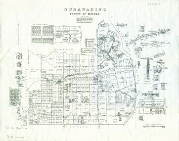
Map, Nunawading, 1972
... Whitehorse Historical Society Inc. 2-10 Deep Creek Road ...Variation of original 1864 map with a number of additions and bold marking of an area including Forest Hill, Vermont and Vermont South as 'Proclaimed survey area No 21 May 1972 2826. Marked as P M Noting Melb SeriesVariation of original 1864 map with a number of additions and bold marking of an area including Forest Hill, Vermont and Vermont South as 'Proclaimed survey area No 21 May 1972 2826. Marked as P M Noting Melb Series.Variation of original 1864 map with a number of additions and bold marking of an area including Forest Hill, Vermont and Vermont South as 'Proclaimed survey area No 21 May 1972 2826. Marked as P M Noting Melb Seriesmaps, shire of blackburn and mitcham, forest hill, vermont, vermont south -
 Whitehorse Historical Society Inc.
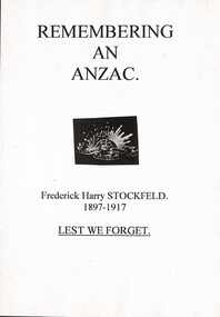
Document - Report, Frederick Henry Stockfield, 1/06/1997
Photocopy of a school assignment. It describes a number of local War Memorials and gives information about Frederick Henry Stockfield who is listed on the Mitcham War Memorials. His family lived in Blackburn Road Blackburn and he had worked picking fruit. He was an artillery man who trained in England and fought in the Third Battle of Ypres. He died of wounds on 21/9/1917 and is buried in the Military Huts Cemetery in Dickenbuscg, Belgium. Photographs of his grave and the cemetery are included. There is information about the life of a Gunner and some about his family. Photographs. Maps. Approx 38 pagesstockfield, frederick harry;, world war 1914-1918. battle of ypres, war memorials -
 Whitehorse Historical Society Inc.
Map, Nunawading, 1970
... Whitehorse Historical Society Inc. 2-10 Deep Creek Road ...Reprint of original map of Shire of NunawadingReprint of original map of Shire of Nunawading with various update but mostly showing 19th century landholders.Reprint of original map of Shire of Nunawadingmaps, shire of nunawading -
Whitehorse Historical Society Inc.
Map, Dandenong Ranges Area, 1956
Sheet 1. Parts of Parishes: Nunawading, Warrandyte and Ringwood. Scale: 10 chains : 1 inch. Contour intervals marked and locations of buildings.Sheet 1. Parts of Parishes: Nunawading, Warrandyte and Ringwood. Scale: 10 chains : 1 inch. Contour intervals marked and locations of buildings. Compiled from aerial photographs and cadastral survey information.Sheet 1. Parts of Parishes: Nunawading, Warrandyte and Ringwood. Scale: 10 chains : 1 inch. Contour intervals marked and locations of buildings. maps, ringwood, mitcham, warrandyte -
 Whitehorse Historical Society Inc.
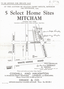
Document, 5 Select Homes Sites Mitcham, 16/11/1929 12:00:00 AM
Auction of land in Mitcham.Auction of land in Mitcham. Includes schetch map of locations and names of purchasersAuction of land in Mitcham. auction, station front estate, mitcham road, mcdowell street, doncaster east road, whitehorse road, coghill & haughton estate agents, drake & co estate agents, roeszler, norman george, edith mary, reid harrison street -
Whitehorse Historical Society Inc.
Article, 'Twin' Teaching at New School, 9/06/1976 12:00:00 AM
The new Primary School proposed at Livingstone Road, Vermont SouthThe new Primary School proposed at Livingstone Road, Vermont South, would be designed for 'closed' and 'open' teaching methods. With map.The new Primary School proposed at Livingstone Road, Vermont Southprimary schools, vermont south primary school, walton, trevor, binaisse, v., cocking, b., knight, b., newsome, m., wickenden, l., head, p. -
Whitehorse Historical Society Inc.
Map, Aerial Photographs Nunawading, 1970
State Aerial Survey, Melbourne 1970.State Aerial Survey, Melbourne 1970. Project runs 34 - 39 - City of Nunawading. Frames numbered from South to North boundaries, each strip numbered from East to West. See table of index and photo numbers attached.non-fictionState Aerial Survey, Melbourne 1970.state aerial survey, aerial photographs, nunawading, mitcham, blackburn, blackburn north, blackburn south, forest hill, vermont, burwood east, vermont south -
Whitehorse Historical Society Inc.
Map, Aerial photographs Nunawading, 1972
Department of Crown Lands and Survey, Melbourne, 1972.Department of Crown Lands and Survey, Melbourne, 1972. Project runs 34 - 39 - City of Nunawading. frames numbered from South to North boundaries, each strip numbered from West to east. The series extends further West to Box Hill and East to Ringwood than the 1970 project. No index map. Sheets 39/2 and 34/28 missing.non-fictionDepartment of Crown Lands and Survey, Melbourne, 1972.victoria. department of crown lands and survey, aerial photographs, nunawading, mitcham, blackburn, blackburn north, blackburn south, forest hill, vermont, burwood east, box hill, ringwood, vermont south -
Whitehorse Historical Society Inc.
Map, Aerial photographs Nunawading, 1976
Department of Crown Lands and Survey, Melbourne, 1976 Project.Department of Crown Lands and Survey, Melbourne, 1976 Project. Runs 29 - 33 City of Nunawading. Frames numbered from South to North boundaries, each strip numbered from West to East. No index map. Sheets 30/8 and 30/9 missing.non-fictionDepartment of Crown Lands and Survey, Melbourne, 1976 Project. victoria. department of crown lands and survey, aerial photographs, nunawading, mitcham, blackburn, blackburn north, blackburn south, forest hill, vermont, vermont south, burwood east, box hill, ringwood -
Whitehorse Historical Society Inc.
Map, M.M.B.W, c1962
Melbourne Metropolitan Area Base Map series sheet 235, covering part, Mitcham, Nunawading and Ringwood areas.Melbourne Metropolitan Area Base Map series sheet 235, covering part, Mitcham, Nunawading and Ringwood areas. Prepared by Department of Lands and Survey and Melbourne and Metropolitan Board of Works from State aerial Survey, June 1957 and Cadastral Survey information, August 1960. Scale 1:4,800.Melbourne Metropolitan Area Base Map series sheet 235, covering part, Mitcham, Nunawading and Ringwood areas. maps, mitcham, nunawading, ringwood, melbourne and metropolitan board of works, victoria. department of lands and survey -
Whitehorse Historical Society Inc.
Map, Ringwood, c1922
Victoria Ringwood Survey map 1 inch to 1 mile.Victoria Ringwood Survey map 1 inch to 1 mile. Covers Eastern suburbs of Melbourne from Richmond to Macclesfield, Heidelberg / Lilydale to Dandenong. Prepared by Commonwealth Section, Imperial General Staff.Victoria Ringwood Survey map 1 inch to 1 mile. eastern suburbs, melbourne, maps -
Whitehorse Historical Society Inc.
Map, Dandenong Ranges Area, 1955
Sheet 13. Parts of Parishes: Nunawading, Mulgrave and Scoresby.Sheet 13. Parts of Parishes: Nunawading, Mulgrave and Scoresby. Includes area of Vermont South marked as proposed Township of Norwich. Scale 10 chains : 1 inch. Contours marked.Sheet 13. Parts of Parishes: Nunawading, Mulgrave and Scoresby. maps, vermont south, wantirna, dandenong creek -
Whitehorse Historical Society Inc.
Map, Shires of Boroondara, Nunawading, C1856
... and Canterbury Roads. Maps Shire of Nunawading Shire of Boroondara ...Photocopy of part of very early map covering parts of Boroondara and Nunawading.Photocopy of part of very early map covering parts of Boroondara and Nunawading. Marks old tracks on lines of Whitehorse and Canterbury Roads.Photocopy of part of very early map covering parts of Boroondara and Nunawading.maps, shire of nunawading, shire of boroondara, barkers track, deep creek, nunawading -
Whitehorse Historical Society Inc.
Map, Shire of Nunawading (part)
Photocopy of map of part of Shire of Nunawading. area along Whitehorse Road from Box hill to Mitcham.Photocopy of map of part of Shire of Nunawading. area along Whitehorse Road from Box hill to Mitcham. Mitcham Station marked as Emery's Hill.Photocopy of map of part of Shire of Nunawading. area along Whitehorse Road from Box hill to Mitcham.maps, shire of nunawading, box hill, blackburn, nunawading, mitcham, emery's hill -
Whitehorse Historical Society Inc.
Map, A Plan of part of the Parish of Nunawading, 1984
Hand drawn plan showing the owners or occupiers of land c1860'.Hand drawn plan showing the owners or occupiers of land c1860'. Includes proposed townships of New Brunswick and Norwich. Scate 1 inch : 10 chains.Hand drawn plan showing the owners or occupiers of land c1860'. maps, shire of nunawading -
Whitehorse Historical Society Inc.
Map, Shire of Blackburn and Mitcham, 1928
Combination of two sheets of detailed map.Combination of two sheets of detailed map. Many subdivisions shown in details with lot numbers.Combination of two sheets of detailed map. maps, shire of blackburn and mitcham -
Whitehorse Historical Society Inc.
Map, Yarra River, 1839
Copy of T.H. Nott's original survey of 'Yarra Yarra River' taken from 'Lilydale' by Grace Aveling.Copy of T.H. Nott's original survey of 'Yarra Yarra River' taken from 'Lilydale' by Grace Aveling. Covers area from Templestowe to Yarra Glen.Copy of T.H. Nott's original survey of 'Yarra Yarra River' taken from 'Lilydale' by Grace Aveling. maps, yarra river -
Whitehorse Historical Society Inc.
Map, Aspinall's old abattoirs, Box Hill, 1937
Hand drawn plan of subdivision of old abattoirs site, Woodhouse Grove, Box Hill North.Hand drawn plan of subdivision of old abattoirs site, Woodhouse Grove, Box Hill North.Hand drawn plan of subdivision of old abattoirs site, Woodhouse Grove, Box Hill North.land subdivision, aspinall's estate, woodhouse grove, box hill north, aspinall road, box hill north, abattoirs -
 Whitehorse Historical Society Inc.
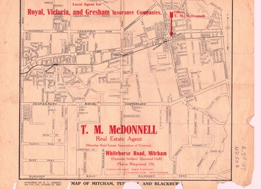
Document, T. M. McDonnell, 1929
Correspondence of T.M. McDonnellCorrespondence of T.M. McDonnell dated 16 October 1929, typed on headed stationery with a 'map of Mitcham, Tunstall and Blackburn'.Correspondence of T.M. McDonnell mcdonnell, t.m., mitcham, nunawading, blackburn, forest hill, vermont -
 Whitehorse Historical Society Inc.
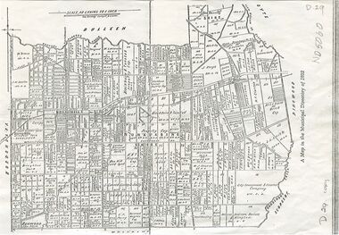
Map, Shire of Nunawading, 1892
... Whitehorse Historical Society Inc. 2-10 Deep Creek Road ...Map of the Shire of Nunawading in the Municipal Directory of 1892e of NunawadingPhotocopy of a map of the Shirew of Nunawading in the Municipal Directory of 1892 showing land owners.Map of the Shire of Nunawading in the Municipal Directory of 1892e of Nunawadingmaps, shire of nunawading -
Whitehorse Historical Society Inc.
Map, Nunawading. County of Bourke, 1878
Photocopy of map of Shire of Nunawading.Photocopy of map of Shire of Nunawading. Note: Fosters v President of the Shire of Nunawading. On Verso: Copied from the most up to date by the Dept of Lands, 1878. Laid before the Executive Council, 11 June 1878. Shows land holders.Photocopy of map of Shire of Nunawading.shire of nunawading, maps -
Whitehorse Historical Society Inc.
Map, Map 1892. Nunawading Shire, 1892
Duplicated same as ND5060 Map of Shire of Nunawading.Duplicated same as ND5060 Map of Shire of Nunawading. Shows railway line including spur from Box Hill to Box Hill Brick Co.Duplicated same as ND5060 Map of Shire of Nunawading. maps, shire of nunawading, railways, box hill brick company -
Whitehorse Historical Society Inc.
Map, Map of Vermont area, c1895
Photocopy of part of a larger map showing the Vermont area.Photocopy of part of a larger map showing the Vermont area. Note on side 'after 1892'. Shows land holders.Photocopy of part of a larger map showing the Vermont area.maps, vermont -
 Whitehorse Historical Society Inc.
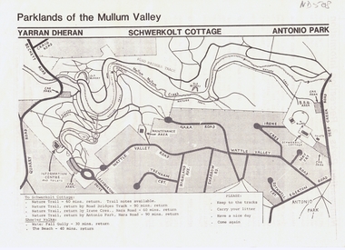
Pamphlet, Parklands of the Mullum Valley, 1998
recreation areas of the Mullum ValleyLeaflet of introduction to the parks and recreation areas of the Mullum Valley including a map of the area. recreation areas of the Mullum Valleyparks and reserves, yarran dheran, schwerkolt cottage, antonio park, mitcham, mullum mullum creek -
Whitehorse Historical Society Inc.
Pamphlet, Tour of Nunawading, 1970s?
Guide, starting at the Civic Centre and stating places of interest. With a cardboard map with numbers.Guide, starting at the Civic Centre and stating places of interest. With a cardboard map with numbers.Guide, starting at the Civic Centre and stating places of interest. With a cardboard map with numbers.city of nunawading, civic centre -
Whitehorse Historical Society Inc.
Article, Tour of City of Nunawading, 1968?
Notes for a tour of the City of Nunawading, with accompanying map.Notes for a tour of the City of Nunawading, with accompanying map.Notes for a tour of the City of Nunawading, with accompanying map.city of nunawading, map -
Whitehorse Historical Society Inc.
Pamphlet, Short History of Nunawading, 1992
Short history of Nunawading, including photos and maps, compiled by the Nunawading Historical Society Inc.Short history of Nunawading, including photos and maps, compiled by the Nunawading Historical Society Inc. Reprinted 1992, with some additional material.Short history of Nunawading, including photos and maps, compiled by the Nunawading Historical Society Inc.nunawading, historical society -
Whitehorse Historical Society Inc.
Document, Vermont pre 1890, 1985?
Short history of Vermont, pre 1890. Nunawading Historical Society competition, first prize, open section. With maps and photographs.Short history of Vermont, pre 1890. Nunawading Historical Society competition, first prize, open section. With maps and photographs.Short history of Vermont, pre 1890. Nunawading Historical Society competition, first prize, open section. With maps and photographs.vermont, nunawading -
 Whitehorse Historical Society Inc.
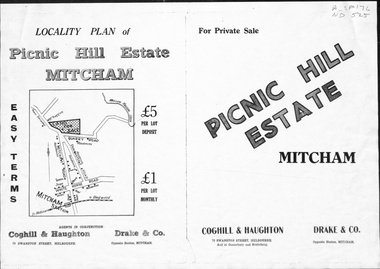
Pamphlet, Picnic Hill Estate, Mitcham, n.d
Photocopy of pamphlet, locality map and plan of 40 home sites on Picnic Hill estate extending from Quarry Road, Mitcham Road and McKeon Road, Mitchamland subdivision, mitcham road, mitcham, quarry road, mckeon road, wooddale grove, rotherwood avenue, cobham road -
Whitehorse Historical Society Inc.
Map, Melbourne and Metropolitan Board of Works, 1925
1925 plan of the Yan Yean, Maroondah and O'Shannassy water supply systems.1925 plan of the Yan Yean, Maroondah and O'Shannassy water supply systems.1925 plan of the Yan Yean, Maroondah and O'Shannassy water supply systems.water supply, melbourne and metropolitan board of works