Showing 1988 items matching "victoria bridge"
-
 Lakes Entrance Historical Society
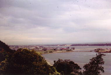
Photograph - Lakes Entrance, Nelson Joan, 1975c
Colour photograph of the township, taken from Jemmys Point. It shows the causeway and raised bridge to Bullock Island, scrub covered sand hummocks and Bass Strait in distance. Lakes Entrance Victoria waterways, topography, township -
 Lakes Entrance Historical Society
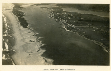
Postcard - Backwater, Bulmer H D, 1922c
Black and white photographic postcard, showing early aerial view of township of Lakes Entrance, Cunninghame Arm, North Arm and sand dunes, ocean in lower foreground, Eastern wharf and various boats on lake. Princes Highway went along Esplanade, Myer Street and Roadknight Street, very little vegetation on sand dunes, no foot bridge yet, good view of North Arm, few houses. Lakes Entrance VictoriaLakes Entrance and Backwater from the Air.islands, aerial photograph, waterways, topography, township -
 Lakes Entrance Historical Society
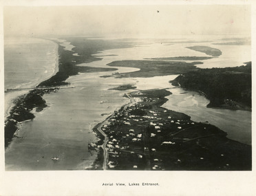
Photograph - Lakes Entrance, 1923c
Two copies 16.5 x 25.5 very darkBlack and white photograph showing early aerial view of township of Lakes Entrance, photo shows highway going along Myer Street and along Roadknight Street, no shops in Myer Street appears to be no foot bridge, therefore taken prior to 1937, sparce vegetation on foreground dunes, four barriers built on dunes to stop erosion through sand, two masted sailing boat in lake. Bullock Island in distance appears very small, Snake Island of Rigby Island in centre distance. Lakes Entrance VictoriaAerial View of Lakes Entrancewaterways, coast, aerial photograph, islands, township -
 Lakes Entrance Historical Society
Postcard - Lakes Entrance, 1923c
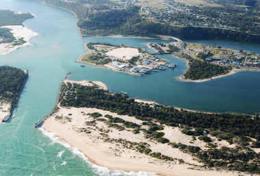
Also large postcard 15 x 20|Also two mini postcard 6 x 9|Also copy black and white 9 x 14.5Black and white postcard of an aerial view of township of Lakes Entrance, showing western end of town, jetties and boat harbours in Cunninghame Arm, the entrance and piers, North Arm bridge, Bullock Island, Rigby, Fraser and Flannegan Islands, and a distant view of Boole Poole, Bunga Arm and Lake King. Lakes Entrance VictoriaAn aerial view showing position of Lakes Entranceaerial photograph, islands, waterways, topography, township -
 Lakes Entrance Historical Society
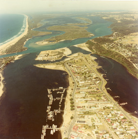
Photograph - Lakes Entrance, 1980c
Colour photograph aerial view of township of Lakes Entrance, showing western end of town, Bullock Island, Cunninghame Arm and North Arm, man made entrance, and distant view of outer barrier, island and shoreline. Lakes Entrance Victoriawaterways, township, bridges -
 Warrnambool and District Historical Society Inc.
Glass Slides, Alex Gunn & Sons, 1930s-1950s
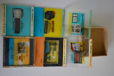
These slides have been made by Alex Gunn and Sons, a 20th century lantern and slide maker based in Melbourne. The slides were produced for Val Morgan and Sons, a cinema advertising slide maker. Val (Valentine) Morgan (1867-1952) established a business in 1894 and by 1914 was making slides for cinemas. By 1921 the business was a company producing slides for movie houses and by the 1930s was the largest business of its type in Victoria. The company also produced the Morgans Street Directory for over 50 years in the 20th century. The company was sold in 1987. It is believed that these slides were shown in the Capitol Theatre in Warrnambool as the advertisements feature a local business, Fletts Plumbing. Most of the slides advertise Metters and Everhot bathroom and kitchen appliances, obtainable from the Warrnambool firm, going under the various trade names of Flett Brothers, F. Flett and Co and Fletts of 147 Lava Street (with ‘Lava’ spelt as ‘Laver’ in one ad). John Flett, boat and bridge builder, settled in Warrnamool in 1868 and it was his son William who first established a tinsmith and plumbing business in Warrnambool in the 1880s in a shop in Timor Street. His sons, Frederick and Charles, continued on the business after the father’s death in a Lava Street site until its demise in the 1950s. These items are of great interest as examples of cinema advertising slides used in cinemas in the mid 20th century and perhaps in the 1930s. The items have local significance as the slides feature advertisements for the business of the Flett family who were local plumbers and fitters. The slides are also of local interest as they are believed to have been used in the Capitol Theatre in Kepler Street, still operating today. These are eleven glass slides produced for cinema advertising in the mid 20th century. Three of the slides are blank and eight contain coloured images and printing advertising the products of kitchen and bathroom items and the local Warrnambool supplier. Four of the slides have thicker glass and four have paper labelling on the top and bottom edges. The slides are held in a cardboard box without a lid.Val Morgan & Sons Pty Ltd Reg. Office 64 Elizabeth Street Melbourne Please screen at least 12 SECONDS Gunn Slide flett family, plumbers, warrnambool, val morgan & sons cinema slides -
 Lakes Entrance Historical Society
Photograph - Lakes Entrance, 2000
Colour photograph aerial view of the entrance, shows entry to North Arm, Cunninghame Arm, Bullock Island, part of Rigby Island, new North Arm Bridge in place, Club Hotel still in situ, small dredge working south west corner of Bullock Island. Lakes Entrance Victoriaislands, waterways, hotels, bridges -
 Lakes Entrance Historical Society
Photograph - Bridges, V S M Series, 1920 c
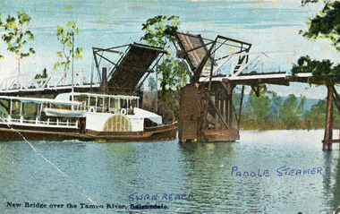
... Swan Reach Bridge on the Tambo River, East Gippsland, Victoria ...Hand tinted postcard showing Paddle Steamer 'Tanjil' passing upstream under the open Swan Reach Bridge on the Tambo River, East Gippsland, Victoria.New Bridge over the Tambo River Swan Reach Paddle Steamerships and shipping, waterways, bridges -
 Lakes Entrance Historical Society
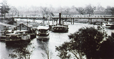
Photograph - Bairnsdale Wharf, 1911
Black and white photograph showing P S Tanjil, S S Gippsland and dredge Pioneer at Bairnsdale wharf, steamer J C D at opposite bank. Early road bridge across Mitchell River. Bairnsdale Victoriaships and shipping, waterways, wharfs, bridges -
 Lakes Entrance Historical Society
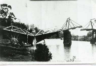
Photograph - Bridges, Bulmer H D, 1925
... bridge pylon. Thick vegetation on bank. Swan Reach Victoria ...Swan Reach Bridge collapsed 10.00 am 16 November 1925Black and white photograph showing collapsed bridge over the Tambo River, bridge collapsed at eastern end. Photo looking downstream. Two people on landing on far right bank behind right hand bridge pylon. Thick vegetation on bank. Swan Reach VictoriaSwan Reach Bridge on the Tambo Riverwaterways, boats and boating, disasters -
 Lakes Entrance Historical Society
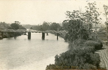
Postcard - Bridges, 1906
Postcard dated 3 December 1913, Bairnsdale, addressed to Mrs Brewer, Metung, Gippsland.Black and white postcard showing wooden lift bridge over Tambo River, Swan Reach, Victoria. Old punt visible at left bank under bank, thick vegetation on right bank, houses in right background above Metung Road.Tambo River, Swan Reachbridges, waterways -
 Lakes Entrance Historical Society
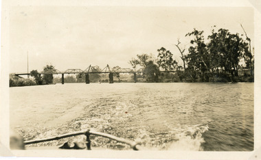
Photograph - Bridges, 1925
... . A tourist launch under the bridge in distance. Swan Reach Victoria ...Photo taken same year Swan Reach bridge collapsed 16 November 1925Black and white photograph of the lifting bridge over the Tambo River taken from the stern of a boat. A tourist launch under the bridge in distance. Swan Reach Victoriabridges, waterways -
 Lakes Entrance Historical Society
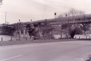
Photograph - Bridges, Fish Marie, 1995
... . Swan Reach Victoria Photograph Bridges Fish Marie ...Black and white photograph showing view of the Swan Reach bridge over the Tambo River. Traffic lights on bridge to control traffic and reduce weight. Swan Reach Victoriabridges, waterways, roads and streets -
 Lakes Entrance Historical Society
Photograph - Bridges, Fish Marie, 1995
... on bridge to control traffic and reduce weight. Swan Reach Victoria ...Black and white photograph showing view of the Swan Reach bridge over the Tambo River. Traffic lights on bridge to control traffic and reduce weight. Swan Reach Victoriabridges, waterways -
 Lakes Entrance Historical Society
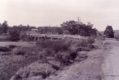
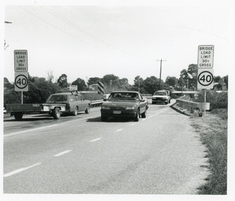
Photograph, 1994
Date made March 1994Black and white photograph showing traffic and restriction signs on Swan Reach Bridge, over theTambo River prior to funding being made available for strengthening and widening. Swan Reach Victoriabridges, waterways, vehicles -
 Lakes Entrance Historical Society
Photograph - Bridges, 1990
... Reach Victoria Photograph Bridges ...Colour photograph showing view of the Tambo River at Swan Reach looking upstream. Boats at jetty on left, vegetation on each bank, poplar trees on right. Swan Reach Victoriabridges, waterways -
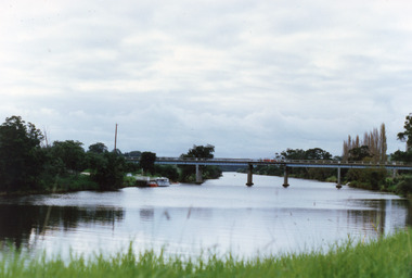
 Lakes Entrance Historical Society
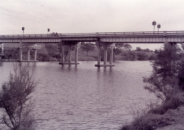
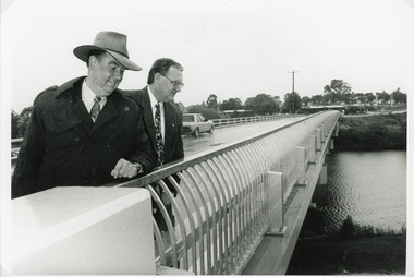
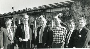
Photograph - Bridges, Lakes Post Newspaper, 1995
... , Victoria. Photograph Bridges Lakes Post Newspaper ...The first concrete bridge built over Tambo River at Swan Reach, in 1932 was never officially opened, so the opening of the refurbished bridge on 19 December 1995 was declared 'The Official Opening'. Photo taken at the Official Opening 19 December 1995Black and white photograph showing David Treasure, MLA, and Norm Butler of VicRoads, on the strengthened and widened bridge, over the Tambo River at Swan Reach, Victoria.bridges, waterways, officials -
 Lakes Entrance Historical Society
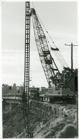
Photograph - Bridges, Lakes Post Newspaper, 1995
... Image appeared in Lakes Post Newspaper 7 June 1995 Bridges ...Image appeared in Lakes Post Newspaper 7 June 1995Black and white photograph showing Whelans crane starting work on the approaches to the Swan Reach bridge, for widening and strengthening works. Swan Reach Victoriabridges, machinery, maintenance -
 Lakes Entrance Historical Society
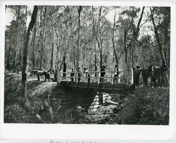
Photograph - Bridges, 1896
... Victoria Photograph Bridges ...Original photo 12.5 x 17 cm on grey card 20 x 24.5 cmBlack and white photograph showing Boggy Creek Bridge,seven men on bridge, one horse at left end of bridge and two horses at right hand end of bridge. Bridge rests on log supports under. No water in creek. Thick bush around area. East Gippsland VictoriaBoggy Creek Bridge - Vic (Written on back)bridges, waterways, vegetation -
 Lakes Entrance Historical Society
Photograph - Bridges, 1994
... Image appeared in Lakes Post newspaper 18 May 1994 Bridges ...Image appeared in Lakes Post newspaper 18 May 1994Black and white photograph of six men standing beside the Tambo River, with the Swan Reach bridge in the background, meeting to stress the poor condition of the bridge and the urgent need for the promised funding. Swan Reach Victoriabridges, waterways, public events -
 Lakes Entrance Historical Society
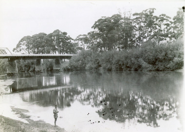
Photograph - Bridges, 1947
... of river. Orbost, Victoria. Photograph Bridges ...Date made February 1947Black and white photograph showing part of the road bridge over there Snowy River, river level low, man in shorts standing at edge of river. Orbost, Victoria.bridges, waterways, recreation -
 Lakes Entrance Historical Society
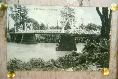
Photograph - Bridges, 1920
... banks. Orbost Victoria Photograph Bridges ...First bridge over the Snowy River at Orbost built 1891Black and white photographic print showing early first bridge across Snowy River thick vegetation along river banks. Orbost Victoriabridges, waterways -
 Lakes Entrance Historical Society
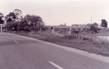
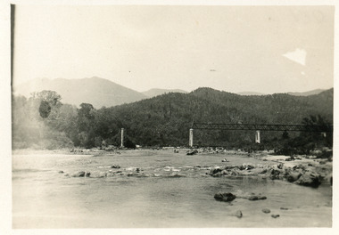
Photograph - Bridges
... , East Gippsland, Victoria. Photograph Bridges ...Black and white photograph showing partially built McKillops Bridge on Snowy River, East Gippsland, Victoria.Cantilever new bridge over Snowy River at McKillops Crossing, 45 feet above recorded flood, washed away before officially opened, decking, etc, down stream more than a mile. (on back)bridges, waterways, topography, construction -
 Eltham District Historical Society Inc
Photograph - Digital Photograph, Alan King, Diamond Creek, Barak Bushlands, Eltham, 2008
A habitat corridor and it strengthens the community. Published: Nillumbik Now and Then / Marguerite Marshall 2008; photographs Alan King with Marguerite Marshall.; p185 Barak Bushlands lie west of the Diamond Creek on the corner of Falkiner Street and busy, noisy Main Road. They form part of an important habitat corridor linking the Yarra River to the Kinglake National Park.1 Manna Gums, tawny frogmouths and platypuses are some of the indigenous plants and animals that have made their home there. The bushlands are the result of more than nine years of hard work by the local community with the Nillumbik Council, to transform a degraded flood plain into this refuge of natural beauty. In 1997, shortly after moving into the new Riverside Estate on Falkiner Street, Eltham, several residents noticed the sorry state of the Diamond Creek and surrounding area. Part of it was used as a cow paddock and although small patches of vegetation survived, the area was infested with weeds, rabbits, rubbish and drainage from the housing estate. At various times the 4.4 hectares had been used as a market garden and for shire stock piles. The residents began to restore the area by revegetating land along the Diamond Creek. In 1998 they established the Friends of the Diamond Creek Falkiner Street Reserve2 and 35 families joined from the 90-house Estate. Carolyn Mellor, as the Friends’ Land Manager, undertook a four-year horticulture course to guide this massive project for a volunteer organisation. Since 1999, she has been the Friends’ President. In 1999 the Friends urged the Nillumbik Council to undertake a feasibility study into establishing a wetland system and urban forest. Work began in 2002 with Nillumbik Council funding the project, supplemented by government grants. The Friends also received grants from Melbourne Water and Parks Victoria. Aided by the Friends and other community members, the Council created the Barak Bushlands consisting of a forest, a wetland, a bridge, a path and open space. The beautiful wetland treats most of the estate’s stormwater runoff. Storm water is filtered through plants in the wetland ponds then is released slowly into the billabong, before flowing into the Diamond Creek. The wetland also helps to minimise flooding and the improved water quality provides a flora and fauna habitat. The Friends and other volunteers planted more than 27,000 plants, more than one third of which they grew from seeds they collected at Lower Eltham and Wingrove Parks. Eltham High School students planted thousands of these through a Year Eight program introduced for this purpose. Other groups who assisted were: Green Corps, local Scouts and Guides – 2nd Montmorency, 1st Diamond Creek and 1st Eltham Cub Packs, Eltham College students, Eltham East Primary School, Landcare members, Eltham Lions Club and the Eltham Baptist Church. To maintain enthusiasm for the mammoth task, the Friends and other volunteers ‘adopted’ trees to water and wrote their names on the stakes. In 2004, to recognise the area’s original occupiers, the reserve was named Barak Bushlands. William Barak, who lived from 1824 to 1903, was the last chief of the Yarra Yarra tribe of the Wurundjeri-willam people. Traces of these original inhabitants remain in scar trees (bark sections removed to make a shield or canoe). That same year the Friends’ group was a finalist in the prestigious Federal Government, Banksia Environmental Awards. The Friends have also participated in Clean Up Australia, removing tonnes of rubbish and regularly testing the billabong, wetland and creek, for pollutants. For years the Friends, together with the Australian Platypus Conservancy, have tagged, measured and checked the health of platypuses from the Diamond and Mullum Mullum Creeks. With Latrobe University the Friends have conducted night walks to view owls, possums, bats and sugar gliders. Challenges for the council and the Friends continue with a large rabbit population, some vandalism, weed eradication and maintenance. However, thanks to this community effort, locals can now escape confined urban living on small blocks of land and enjoy the beauty of indigenous plants and animals. Working together has also strengthened the local community,This collection of almost 130 photos about places and people within the Shire of Nillumbik, an urban and rural municipality in Melbourne's north, contributes to an understanding of the history of the Shire. Published in 2008 immediately prior to the Black Saturday bushfires of February 7, 2009, it documents sites that were impacted, and in some cases destroyed by the fires. It includes photographs taken especially for the publication, creating a unique time capsule representing the Shire in the early 21st century. It remains the most recent comprehenesive publication devoted to the Shire's history connecting local residents to the past. nillumbik now and then (marshall-king) collection, barak bushlands, diamond creek (creek), eltham -
 Lakes Entrance Historical Society
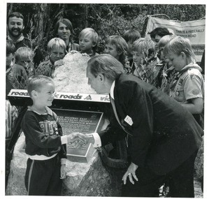
Photograph - Bridges, Lake Post Newspaper, 1991
... Bridges Celebration Black and white photograph taken ...This photo appeared in the L P Newspaper 13 November 1991Black and white photograph taken at the celebration to open the new concrete Princes Highway bridge over Toorloo Arm. Plaque unveiled by Minister for Land Transport, Bob Brown, seen greeting the youngest member of the community, Toorloo Arm Sea Scouts in attendance. Toorloo Arm Victoriabridges, celebration -
 Lakes Entrance Historical Society
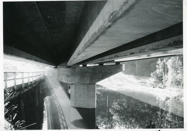
Photograph - Bridges, Lakes Post Newspaper, 1991
... . Toorloo Arm Victoria Photograph Bridges Lakes Post Newspaper ...This photo appeared in the Lakes Post Newpaper 24 July 1991Black and white photograph looking under the decking of the new Princes Highway concrete bridge over Toorloo Arm, showing the support pier shaped to fit the camber of the curved bridge. Timber bridge in left of image still in use. Toorloo Arm Victoriabridges, construction -
 Lakes Entrance Historical Society
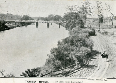
Postcard - Bridges, 1906
First timber road bridge over the Tambo River at Swan Reach officially opened 20 December 1905, after which punt was removed to BairnsdaleBlack and white postcard of the lifting bridge over the Tambo River at Swan Reach, Victoria. Man on horse standing on dirt road to Metung beside the river. Punt previously used to cross river visible against western bank of river.Tambo River (16 miles from Bairnsdale)bridges, waterways -
 Lakes Entrance Historical Society
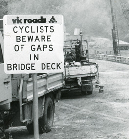
Photograph, Lakes Post Newspaper, 1991
Date made January 1991Black and white photograph taken when work commenced on the construction of the new concrete bridge on the Princes Highway, Toorloo Arm, near Lakes Entrance. Road works in distance, crane beside present bridge, Vicroads warning sign to cyclists in foreground. Toorloo Arm Victoriabridges, waterways