Showing 10617 items
matching sites
-
 Ringwood and District Historical Society
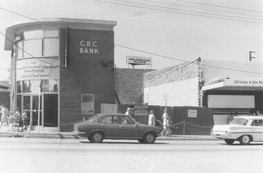
Photograph, Extension of C.B.C. Bank, Ringwood, January 1974. (On corner of Ringwood railway station entrance and Maroondah Highway)
Black and white photographWritten on back of photograph: "Jan. 1974. Extension of C.B.C. Bank on site formerly occupied by C.E. Carter and Son, Estate Agents. Carters took over butcher shop." -
 Ringwood and District Historical Society
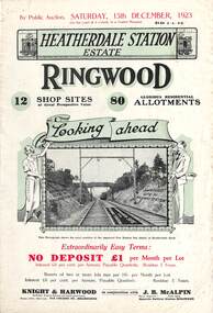
Flyer, Subdivisional Land Auction Sale Brochures, Heatherdale Station Estate, Ringwood, Vic. - 1923 and 1924
Two double sided multi-folded pages advertising public auction sales of shop sites and residential allotments on Saturday, 15th December, 1923 and Saturday, 2nd February, 1924, including summary of local facilities, services and map showing layout of the estate. Includes a photograph depicting proposed site for first Heatherdale railway station and a panoramic view of Ringwood from the railway level crossing in Heatherdale Road. 1923 and 1924 flyers are identical except for the auction dates printed at the top.Subdivision includes Heatherdale Road, Molan Street, Yallourn Parade, Newman Street, and Madden Street. Agents - Knight & Harwood, 315 Collins Street, Melbourne, Phone 10615, 10616 Central, in conjunction with J.B. McAlpin, Opposite Railway Station, Ringwood. Phone Ringwood 7. -
 Bendigo Historical Society Inc.
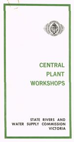
Document - STATE RIVERS AND WATER SUPPLY COMMISSION VICTORIA : CENTRAL PLANT WORKSHOPS
State Rivers and Water Supply Commission of Victoria. Brochure titled 'Central Plant Workshops'. Double-sided, three pages on each. Information about the workshops (CPW for short) and the setting up of the Bendigo site from 1946. There is a map of the layout of the site, and information given under the following headings - Central Plant Workshops, Work of the CPW, Meter Wheels, Pump Station Equipment, Steel Fabrication, Precast Concrete, and the Area and its Equipment. The brochure is dated June, 1968.state infrastructure, water supply, coliban system, state rivers and water supply commission of victoria. coliban system. central plant workshops. -
 The Beechworth Burke Museum
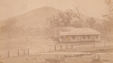
Photograph - Carte de Visite, William E Barnes
In July of 1880, Ann Jones' successful hotel in Glenrowan burnt to the ground during the Kelly siege. She had opened her business in the year prior having been unsuccessful in her attempt to run a tea-room business in Wangaratta. The first building on this particular site was the home Ann Jones had built for herself and her family. Two years later she converted the home and added the hotel to the rear of the structure. One year later it was burnt to the ground. This image depicts the streetscape of Glenrowan in 1883, three years after the siege. Importantly, it reveals the appearance of several buildings which can reveal information for how Glenrowan (as a small town) might have stood during the siege. These buildings are of typical Australian colonial "miner's cottage" style. On what would have been the site of Ann Jones' hotel, to the far left of the photograph, a police station stands. This police station was built before April 1883. This Carte-de-viste (CdV) taken by renowned Wangaratta based photographer William Edward Barnes previously belonged to the donor's grandfather, Daniel Mullins who was a Police Officer stationed at Glenrowan soon after the Kelly gang siege. Today, the siege has become an important part of Australian culture and Ned Kelly and the Kelly Gang (comprising of Ned Kelly, Dan Kelly, Steve Hart and Joe Byrne) has become ingrained in Australian history and mythology. A CdV is a sepia toned photograph mounted on card and is generally of a small size. This particular style was first patented by Andre Adolphe Eugene Disdéri (1819-1889) in 1854. In 1857, the CdV was introduced to England and after photographs of Queen Victoria, Prince Albert and their family were taken using CdV in 1860 the popularity of this method reached a peak.This photograph is part of the Burke Museum "Kelly album" which includes a significant collection of photographs and artefacts connected to Ned Kelly and the Kelly Gang. Ned Kelly and his gang have become ingrained in Australian popular culture and thus many museums, art galleries and private collections house material connected to the Kelly story which allows the events and people to be researched and interpreted. Artefacts and photographs pertaining to the Kelly gang are particularly valuable for Australian museums. This particular photograph is significant for its connection to Wangaratta based photographer William Edward Barnes and to the Glenrowan Siege and Ann Jones' Hotel which burnt down during the siege in June 1880. Taken in 1883, this photograph has the opportunity to provide information about the townscape of Glenrowan shortly after the siege. It also provides important insight into the architecture and layout of the town. To the far right of the image, the photograph depicts the police station which was built on the site of Ann Jones' Hotel which can provide important information for the Kelly story and how the town evolved following 1880. It is also interesting to emphasise that the police station was built on the site of Ned Kelly and the Kelly gang's last stand.This photograph is a sepia image mounted on yellow card which depicts the newly built police station (in 1882) which stands on the far right of the image on the site of the former Ann Jones Hotel. A fence appears through the lower front of the image and an open paddock is to the left. In the rear centre of the image, there is a mountain. In front of the mountain are many trees, most of them gum. The police station is a one storey structure with a veranda and there are three doorways visible in the image. The image depicts four windows on the front of the station.W.E.Barnes / photographer / Wangaratta / ...1882 / BMM8087kelly album, william barnes, wangaratta photographer, carte-de-viste, glenrowan, 1882, police station, ann jones inn, ann jones hotel, kelly siege, glenrowan siege, colonial australia -
 Falls Creek Historical Society
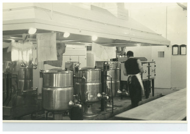
Photograph - Inside Pretty Valley Camp Kitchen
MEYER COLLECTION - FALLS CREEK PHOTOS In 1947 a determined group of like-minded State Electricity Commission (SEC) staff including Ray Meyer, the chief surveyor of the Kiewa Hydro-Electric Scheme, had a common interest that revolved around the skiing potential of the snow-covered high plains which included what is now the resort of Falls Creek. The six SEC employees, Toni St Elmo, Ray Meyer, Jack Minogue, Lloyd Dunn, Adrian Ruffenacht and Dave Gibson (together with their families) banded together to secretly build a 'hut' that was the first ski lodge at Falls Creek. Using a road built in 1930s to gain access to Falls Creek, their hut project was carried out in secret as efforts by other skiers were blocked by H.H.C. Williams – the engineer in charge of the Hydro Scheme. In 1946 Ray Meyer made a trip to the Lands Office in Melbourne. He came away with a 99-year lease on three acres that was ideally suited for a hut designed by Lloyd Dunn. Adrian Ruffenacht (Design Engineer for the KHS) had suggested where the group should build because of easy access to a spring for water. Much of the building material required was scavenged from derelict huts on the high plains. Due to the need for secrecy, the determined group worked on the hut in the evenings and weekends to avoid detection. During the building period the group had met at Echidna Rock (now known as Eagle Rock) where Skippy St Elmo announced, "This is my favourite ‘Skyline’.” And so the first lodge in the area at Falls Creek Ski Resort came into existence. With the development of the International Poma in the 1970s, the Skyline Lodge, which was sited between the ski-lift’s pole one and pole two, was demolished. However, the legacy of Ray Meyer, Toni St Elmo, Jack Minogue, Lloyd Dunn, Adrian Ruffenacht and Dave Gibson and Skyline lives on in the vibrant atmosphere of Falls Creek Resort. The MEYER COLLECTION documents developments on the Kiewa Hydro Scheme and their life at Falls Creek from the mid 1930s to 1960s.This image is significant because it documents the development of the Kiewa Hydroelectric Scheme.A black and white photo taken inside the Pretty Valley Camp kitchen. Staff quarters was completed in April, 1947 and accommodation for workmen commenced in 1948 but was suspended from May until November. Construction of this camp was completed in 1949. A large dam was proposed at this site but it was never constructed, being replaced by a smaller diversion dam.falls creek, victorian snowfields, pretty valley -
 Kiewa Valley Historical Society
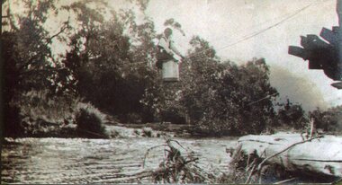
Photo - Tawonga Bridge.( Set of 2 photos)
Photo 1 - Rene Roper (Postmistress) crossing swollen Kiewa River on a milk can flying fox at Tawonga, during high winter waters Photo 2 - First Tawonga bridge was built in 1884- destroyed by floods in 1916. New bridge constructed 1923 and destroyed in 1953. Present concrete bridge constructed in 1986 and named Ryders BridgeBridge construction over Kiewa River at TawongaCopies of two original black and white photos. Photo 1 - Flying fox at site of Tawonga Bridge over the Kiewa River Photo 2 - Timber pile bridge over the Kiewa River at Tawongatawonga bridge, kiewa valley -
 Kiewa Valley Historical Society
Photograph – Photocopy of black and white photograph of Bogong Creek Race Line. 17/1/51, 17/01/1951
A start on the construction of Bogong Creek race line was made at the commencement of winter in 1948. Work proceeded in the following years when work on the High Plains was not practicable. In January, 1951 the special trimming machine, the special slip form and concrete mixing and placing equipment was put into service. A shortage of cement caused some delays as well as a sudden financial recession. The race line was completed and put into service in 1952.An historical record showing the machinery used during this time, the number of workers and supervisors involved and the mountainous terrain where they worked. It also demonstrates the OH&S of the period with workers mostly in street clothing with no hard hats or other safety equipment. Several workers can be seen working shirtless or in singlets.Photocopy of a black and white SECV photograph No: K 6209 labelled Bogong Creek Race Line ch. 1700. Depicting large group of workers and supervisors working at the site. Dated 17/1/52Printed underneath the photograph: STATE ELECTRICITY COMMISSION OF VICTORIA Date: 17/1/51 Time: 10.30am No: K 6209 Kiewa Hydro-Electric Works Bogong Creek Race Line ch. 1700 bogong creek raceline; secv; kiewa hydro electric scheme; -
 Phillip Island and District Historical Society Inc.
Photograph, 1900's
This postcard is contained in an album presented to the then Governor of Victoria, The Earl of Stradbroke, by the fathers of soldiers & returned soldiers of Phillip Island, on 16/02/1923. The history of the album is noted on Reg. No 85-00Postcard of Beach Road, Cowes, showing stable on site of Continental Hotel, where horse and drags collected passengers to take to Summerland, early 1900's. Moreton Bay Fig planted by Von Mueller.The Rose Series P674. Beach Road Cowes, Phillip Island, Victorialocal history, photography, photographs, slides, film, beach road, cowes, phillip island, the esplanade, transport, moreton bay fig, sepia photograph, beach road cowes -
 Phillip Island and District Historical Society Inc.
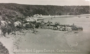
Photograph, Mutton Bird Eggers' Camps, Cape Woolamai
Part of a collection of 'Rose & Valentine' series of Post Cards. Copied by John Jansson 1984Mutton Bird eggers camps Cape Woolamai showing tent sites, boats in bay. Several figures standing on the old stone jetty built from red Woolamai granite. Part of the Granite Quarry.Mutton Bird eggers' camps Cape Woolamai.local history, photography, photographs, postcards, phillip island, mutton bird eggers camp, cape woolamai -
4th/19th Prince of Wales's Light Horse Regiment Unit History Room
Document - Bulletin, Royal Australian Armoured Corps Bulletin No 35, May 1958
A nine page document containing an invitation for units and individuals to contribute articles, a list of appointments, a list of CMF camps, a list of sites to which CMF units have been transferred, and a list of officer postings.raac bulletin, raac -
 Federation University Historical Collection
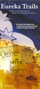
Brochure, The Eureka Trails, c2005
The brochure gives information on the Eureka Stockade which took place on 03 December 1854.Double sided A3 brochure with colour reproductions of scenes related to the Eureka Stockade. The brochure includes a map showing the route the Government forces took on their way to the Eureka Stockade as well as sites of interest to Eureka. eureka, eureka stockade, diggers' trail, trooper's trail -
 Federation University Historical Collection
Photograph - Photograph - Black and White, Muddy Courtyard in front of the E.J. Barker Library
The Mt Helen campus was purchased in 1967 and the first students studied at Mt Heen in 1970. Black and white photograph of a muddy construction site on Mount Helen Campus, with the E.J. Barker Library in the background. The muddy area later became the courtyard in front of the Albert Coates Building (formerly Union Building) mount helen library, e.j. barker library, courtyard, s building, mount helen campus, brutalism -
 Bendigo Historical Society Inc.
Document - BENDIGO CEMETERIES COLLECTION: SELF GUIDED TOUR NO. 8 DOCUMENT
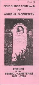
Pink document trifold. Self Guided Tour No. 8 of White Hills Cemetery, Friends of the Bendigo Cemeteries 2002 - 2003. Theme of tour 'Symbolism in White Hills Cemetery' Map with numbered grave sites.Friends of Bendigo Cemeteries 2002bendigo, cemetery, white hills cemetery tour -
 Bendigo Historical Society Inc.
Newspaper - JENNY FOLEY COLLECTION: HOUSE OF POWER
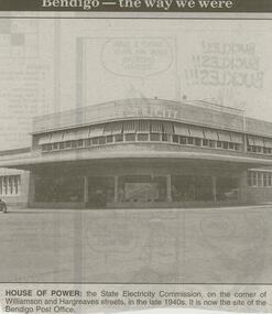
Bendigo Advertiser ''The way we were'' from 2000. house of power: the State Electricity Commission, on the corner of Williamson and Hargreaves streets, in the late 1940s. It is now the site of the Bendigo Post Office. The clip is in a folder.newspaper, bendigo advertiser, the way we were -
 Bendigo Historical Society Inc.
Photograph - LA TROBE UNIVERSITY BENDIGO COLLECTION: COURTHOUSE
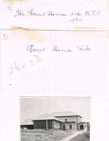
One black and white photo, one proof and one negative of the Court House in a white envelope. On the envelope is written 'The Court House site B.T.C. 1930.' On the top left hand side is the number 3.bendigo, education, old courthouse, la trobe university bendigo collection, collection, bendigo, education, tertiary education, court house, old court house, place, buildings, bendigo teachers' college, photograph, photo, negative, proof -
 Bendigo Historical Society Inc.
Document - GOLDEN SQUARE HIGH SCHOOL COLLECTION: PLAN OF PROPOSED SCHOOL SITE
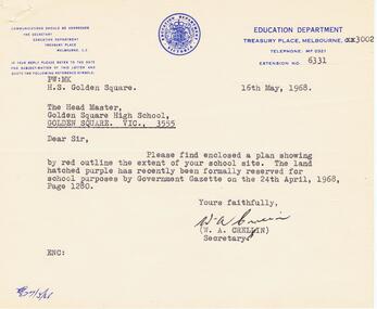
Letter from Education Department to the Head Master, Golden Square High School dated 16th May, 1968. Enclosed plan showing the extent of school site. The letter is signed by W. A. Crellin (Secretary).education, secondary, golden square -
 Bendigo Historical Society Inc.
Slide - RALPH BIRRELL COLLECTION: EIG SCHOOL, c1966
EIG School - Ralph Birrell Collection. - Construction of Latrobe Uni. C1967. Bendigo Institute of Technology, Engineering School, Applied Science. Site levelled and reinforcing is about to go in place. Height poles in place.Kodakeducation, tertiary, latrobe university bendigo, eig school - ralph birrell collection. - construction of latrobe uni. c1967. bendigo institute of technology, engineering school, applied science. site levelled reinforcing height poles -
 Port Melbourne Historical & Preservation Society
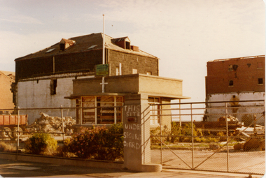
Photograph - Harper's factory buildings, Beach and Rouse Streets, Port Melbourne. Demolition works, April 1977
Harper factory buildings on Beach and Rouse Streets (colour photo). April 1977 View shows that demolition works have commenced. Roughly painted sign on gates saying "this site under security guard"built environment, built environment - commercial, harper's, demolition -
Port Melbourne Historical & Preservation Society
Photograph - Temporary City of Port Melbourne library, Howe Parade, Jan 1988
Two colour photos of the Port Melbourne library building situated in the former laboratory block of BP Oil Company, Howe Parade, whilst the new library was being built on the supermarket site. January 1988built environment - civic, built environment - industrial, port melbourne library, bp australia, howe parade -
Port Melbourne Historical & Preservation Society
Letter - Department of Lands and Survey re proclaimation for site of Town Hall, Sandridge, Department of Lands and Survey, 30 Dec 1861
Handwritten letter on blue foolscap laid paper, from Dept of Lands and Survey 30.12.1861 directing attention to proclamation in Government Gazette re site for Town Hall at Sandridge. Paper, watermarked with Britannia symbollocal government - borough of sandridge, port melbourne town hall -
 Bendigo Historical Society Inc.
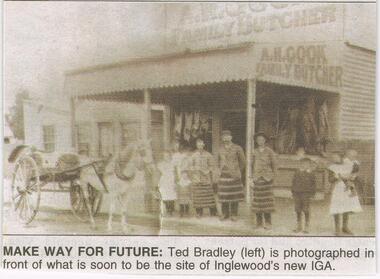
Newspaper - JENNY FOLEY COLLECTION: MAKE WAY FOR FUTURE
Bendigo Advertiser ''The way we were'' from Thursday, June 16, 2005. Make way for future: Ted Bradley (left)mis photographed in front of waht is soon to be the site of Inglewood's new IGA.newspaper, bendigo advertiser, the way we were -
 Tatura Irrigation & Wartime Camps Museum
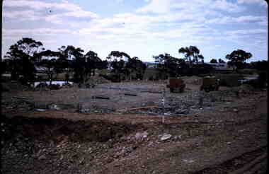
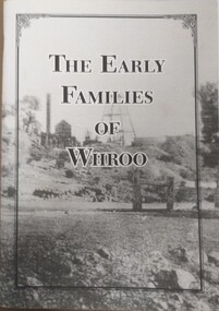
Booklet, The Early Families of Whroo
Tells a short story of the early families who settled at Whroo, a gold mining area, located near Rushworth. The town is no long in existence. Written by Doris KIngA5 size booklet with soft cardboard cover. Cover has a black frame in from the edge with the book title in that in black print. Cover is a grey scale photograph of the Whroo mining site. 88 pages.titlewhroo, families of whroo, doris king -
 Hume City Civic Collection
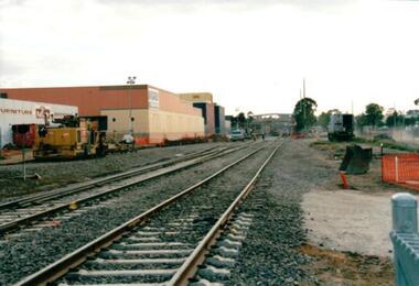
Photograph, 21/04/2005
This photograph was taken during the upgrade of the Bendigo Railway line at Sunbury Station. The upgrade took twelve months to complete and during that time bus services replaced the trains.A coloured photograph of construction on the site of the Sunbury Railway Station. The photograph was taken near the Station Street level crossing and is looking north towards the Sunbury Station. The new tracks have been put into place.railways, bendigo line, railway stations, bridges, sunbury railway station, george evans collection -
 Hume City Civic Collection
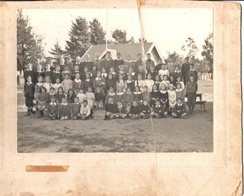
Photograph, 1914
A b/w photograph mounted on card of students of Sunbury State School No. 1002 taken in 1914. The group is taken in front of the shelter shed on Macedon Street site. (Names are on the photo and also on catalogue worksheet)Printed on front: Sunbury State School 1914 / "see on back"schools, sunbury state school, macedon street, sunbury, dempsey, bill, walls, stan, -, neville, trask, con, clayton, 'doctor', parke, cecil (saishle), griffins, maurice, ter hofstede, gerat, s, g., titford, willie, healey, perc, austin, johnnie, boardman, eric, wilson, don, smith, d. n., williams, will, baker, arthur, johnstone, bert, clarence, 'darkie', mclauchlin, bob, annie, jamieson, jessie, gilchrist, hazel, balfour, jean, rita, leggett, betty, curry, jim, hudson, ted, ray, flintoft, billie, syd, finn, jack, hilda, mavis, florence, gregor, lilian, dorothy, mclellan, alice, stagoll, millie, polly, leggo, margaret, bailey, lily, mcgregor, butcher, ruth, burke, connie, nellie, ella, alma, phillips, sadie, coggins, eileen, johnston, george, olive, gordon, effie, iris, vera, down, len, mickie, gilmour, wil, wykes, laurie, lacey, alan, huf, c. w. (mrs), shelter sheds, 1910s, george evans collection -
Lakes Entrance Regional Historical Society (operating as Lakes Entrance History Centre & Museum)
Book, Rogers, J. G. and Hellyer, Nellie, Lonely Graves of the Gippsland Goldfields and Greater Gippsland, 1994
Description of burial sites and details of circumstances of deaths of many persons buried in lonely and out of the way places across Gippsland. Indexed under locality and family name. Contains bibliography and glossary of causes of death.Nelly Hellier, J.G. Rogers. Aug.1994bibliography, cemeteries -
Lakes Entrance Regional Historical Society (operating as Lakes Entrance History Centre & Museum)
Book, Reid, Richard, North Beach Gallipoli 1915, 2001
This booklet has been produced to assist visitors to the Anzac Commemorative site to understand more fully the significance of the area. Illustrated with drawings by Major Leslie Hore, which convey sights and sounds of the Gallipoli campaign.military history -
 Whitehorse Historical Society Inc.
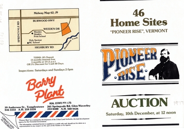
Document, Pioneer Rise, ca 1977
Brochure advertising auction of 'Pioneer Rise',Brochure advertising auction of 'Pioneer Rise', Vermont South. 46 sites offered by the Urban Land Authority 10 December 1977?. Agent Barry Plant Real Estate Pty Ltd. Colour photos.Brochure advertising auction of 'Pioneer Rise', auctions, vermont south, pioneer rise, pioneer close, sewart close, mont court, victoria. urban land authority -
Whitehorse Historical Society Inc.
Article, Historic hostel bulldozed for development, 1994
Historical Leawarra Hostel on the former Winlaton site has been bulldozed for proposed residential subdivision in two lots.Historical Leawarra Hostel on the former Winlaton site has been bulldozed for proposed residential subdivision in two lots. The building was once the home of Joseph Tweedle[Tweddle] who financed the Tweedle Hospital in Footscray.Historical Leawarra Hostel on the former Winlaton site has been bulldozed for proposed residential subdivision in two lots. winlaton, leawarra hostel, tweddle, joseph -
Whitehorse Historical Society Inc.
Document, Archie's Story, 1998 ?
Brief history on Eastside Plants (Archies Cafe, Nunawading). Land previously site of market garden owned by Archie McArthur. After Archie's death in late1990's, his house was converted into Archies Cafe.pioneers, market gardens, plant nurseries, eastside plants, archies cafe, mcarthur, archibald, gourlay, robert, lalor, peter -
Whitehorse Historical Society Inc.
Newspaper - Article, Federal Plan to sell former Migrant Centre, 25/09/1985
Article from Nunawading Gazette, 25th September, 1985, re the Sale of Eastbridge Migrant Property in Rooks Road, Nunawading. The 22 1/2 acre site seems certain to be sold for Housing Development.eastbridge migrant hostel, rooks road, nunawading