Showing 2146 items
matching bendigo and district
-
 Bendigo Historical Society Inc.
Map - CAMPBELL COLLECTION: BENDIGO AND DISTRICT MAPS, 8-7-29
Map. Rifle Range, Parishes of Wellsford and Sandhurst. Scale 20 chains to 1 inch. Total area by Planimeter 5916 acres. Wallan and Bendigo Railway line. Rifle Range. Axedale township and station 8 miles. To Longlea Ryl station 2 1/2 miles. To Epsom 1 1/2 miles. To Bendigo 3 miles. Compiled in W.P.D. from Assessment and Parish Plans by H.A.D 8-7- 29 (number 367 in map cupboard 1)H.A.D.(H.A.Darby)map, bendigo, allotments -
Bendigo Historical Society Inc.
Map - CAMPBELL COLLECTION: BENDIGO AND DISTRICT MAPS, 16-5-29
Map. Egerton, Parishes of Egerton and Whirrakee. Scale 20 chains to 1 inch. Total area 5401 acres. Prepared in W.P.B. from A. and C.L. Plans by W.J.G. 16-5-29. To Rochester 12 miles. (number 366 in map cupboard 1)W.J.G.(W.J.Galbraith)map, bendigo, allotments -
Bendigo Historical Society Inc.
Map - CAMPBELL COLLECTION: BENDIGO AND DISTRICT MAPS
Map. Kimbolton, Parishes of Kimbolton and Lyell, scale 20 chains to 1 inch. Area by Planimeter 6258 acres. Knowsley. 10 1/2 miles to Strathfieldsaye. Campaspe River at bottom right of map. (number 365 in map cupboard 1)map, bendigo, allotments -
Bendigo Historical Society Inc.
Map - CAMPBELL COLLECTION: BENDIGO AND DISTRICT MAPS, 16-4-29
Map. Kennington, Parishes of Sandhurst, Mandurang and Strathfieldsaye. Scale 20 chains to 1 inch. Total area 2918 acres. Bendigo 2 1/2 miles. Prepared in W.B. from A.and C. L. Plans by W.J. Galbraith, 16-4-29. (number 364 in map cupboard 1)W.J.Galbraithmap, bendigo, allotments -
Bendigo Historical Society Inc.
Map - CAMPBELL COLLECTION: BENDIGO AND DISTRICT MAPS
Map. Mandurang, Parish of Mandurang, Scale 20 chains to 1 inch. Total area 5993 acres, Northern Railway to left of map, Water Reserve (Spring Gully). (number 363 in map cupboard 1)map, bendigo, allotments -
Bendigo Historical Society Inc.
Map - CAMPBELL COLLECTION: BENDIGO AND DISTRICT MAPS
Map. Marong, Parishes of Marong, Lockwood and Mandurang. Scale 20 chains to an inch. Total 5106 acres. Compiled in W.P.B. from Field Survey and Parish Plans. Crusoe Reservoir to the right of map. (number 362 in map cupboard 1)map, bendigo, parish plan -
Bendigo Historical Society Inc.
Map - CAMPBELL COLLECTION: BENDIGO AND DISTRICT MAPS, 2-2-29
Map. Wellsford, Parishes of Wellsford and Axedale, Scale 20 chains to 1 inch. Total area 4994 acres. Prepared in W.P.B. from A and P Plans, by W.J.G.2-2-29. Top left of map are directions to Fosterville, Huntly & Bendigo. (number 361 in map cupboard 1)W.J.Galbraithmap, bendigo, parish plan -
Bendigo Historical Society Inc.
Map - CAMPBELL COLLECTION: BENDIGO AND DISTRICT MAPS
Map. Sedgwick. Continuation of 10104.13. (number 360 in map cupboard 1)map, bendigo, agricultural lands -
Bendigo Historical Society Inc.
Map - CAMPBELL COLLECTION: BENDIGO AND DISTRICT MAPS
Map. Sedgwick. Parishes of Strathfieldsaye, Lyell and Sedgwick. Scale 20 chains to 1 inch. (number 359 in map cupboard 1)map, bendigo, agricultural lands -
Bendigo Historical Society Inc.
Map - CAMPBELL COLLECTION: BENDIGO AND DISTRICT MAPS
Map. Lockwood, Parishes of Lockwood and Shelbourne, scale 20 chains to 1 inch. Spring Creek centre of map and Bullock Creek to the right. Total area 4405 acres. (number 358 in map cupboard 1)map, bendigo, allotments -
Bendigo Historical Society Inc.
Map - CAMPBELL COLLECTION: BENDIGO AND DISTRICT MAPS
Map. Eppalock, Sedgwick and Strathfieldsaye, scale 20 chains to 1 inch. Road to Bendigo 13 1/2 miles at top right of map, Longlea Railway Station 5 1/2 miles, Bendigo 11 miles, Strathfieldsaye 5 miles on left of map. Total area 3972 acres. Prepared in W.P.B. from Assessment Plan and Parish Plans. H.A. Darby 14-6-29.H.A.Darbymap, bendigo, agricultural lands -
Bendigo Historical Society Inc.
Map - CAMPBELL COLLECTION: BENDIGO AND DISTRICT MAPS, 15-2-29
Map. Nerring, Parish of Nerring, scale 20 chains to 1 inch. Prepared in W.J.B. from A and B plans by W.J. Galbraith 15-2-29. (number 356 in map cupboard 1)W.J.Galbraithmap, bendigo, parish plan -
Bendigo Historical Society Inc.
Map - CAMPBELL COLLECTION: BENDIGO AND DISTRICT MAPS
Map. Ascot Unit, scale 20 chains to an inch, arrow pointing to magnetic north, road to Fosterville to the East, Huntly 3/4 mile to the West, road to Epsom 3/4 mile and road to Bendigo 4 1/2 miles south west on map, also on page is the Northern Railway (Bendigo to Echuca) line. (number 355 in map cupboard 1)map, bendigo, country lands -
Bendigo Historical Society Inc.
Map - CAMPBELL COLLECTION: BENDIGO AND DISTRICT MAPS
Map. Ellesmere, Parish of Ellesmere. Scale 20 chains to 1 inch. Total area 3926 acres. Prepared in W.P.B. from A and P plans. (number 354 in map cupboard 1)map, bendigo, agricultural lands -
Bendigo Historical Society Inc.
Map - CAMPBELL COLLECTION: BENDIGO AND DISTRICT MAPS, 8-2-29
Map. Bagshot, Parishes of Wellsford, Ellesmere and Bagshot. Scale 20 chains to 1 inch. Total area 5037 acres. Prepared in W.P.B. from A.C.l. and D.B. Plans, W.J. Galbraith, 8-2-29 (number 353 in map cupboard 1)W.J.Galbraithmap, bendigo, agricultural lands -
Bendigo Historical Society Inc.
Map - CAMPBELL COLLECTION: BENDIGO AND DISTRICT MAPS, 12-2-29
Map. Axedale, Parishes of Ellesmere and Axedale. Scale 20 chains to 1 inch. To the west is Wellsford. Total area 4156 acres. Prepared in W.P.B. from A and P plans by W.J. Galbraith 12-2-29. (number 352 in map cupboard 1)W.J.Galbraithmap, bendigo, agricultural lands -
Bendigo Historical Society Inc.
Map - CAMPBELL COLLECTION: BENDIGO AND DISTRICT MAPS, 1929
Map. Campaspe, Parish of Kimbolton. Total area 4117 acres. Campaspe River, Kimbolton. Scale 20 chains to 1 inch. Prepared in W.P.B. form Parish and Assessment Plans. G.W.L. 9-4-29. (number 351 in map cupboard 1)map, bendigo, allotments -
Bendigo Historical Society Inc.
Map - CAMPBELL COLLECTION: BENDIGO AND DISTRICT MAPS
Map. Whirrakee, Parish of Whirrakee. Total area of map 4419 acres. Scale 20 chains to 1 inch. 23 allotments are sold, Eucalypt oil distillery on lower portion of map. Prepared in W.P.B. from Assessor's plan and Parish Plan. (number 350 in map cupboard 1)map, bendigo, allotments -
Bendigo Historical Society Inc.
Map - CAMPBELL COLLECTION: BENDIGO AND DISTRICT MAPS
Map. Longlea, Parishes of Eppalock and Axedale. Scale 20 chains to 1 inch. Total area of map 2372 acres, with Bendigo 9 1/2 miles away. H.A. Darby 18-6-29. (number 349 in map cupboard 1)H.A Darbymap, bendigo, allotments -
Bendigo Historical Society Inc.
Map - CAMPBELL COLLECTION: BENDIGO AND DISTRICT MAPS
Map. Lyell, Parishes of Sedgwick, Eppalock and Lyell. Scale 20 chains to 1 inch. (number 348 in map cupboard 1)map, bendigo, agricultural lands -
 Bendigo Historical Society Inc.
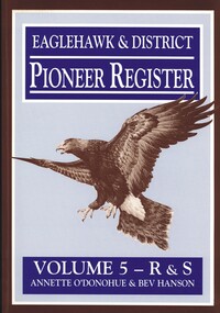
Book - EAGLEHAWK & DISTRICT PIONEER REGISTER VOLUME 5 R - S
Eaglehawk & District Pioneer Register Volume 5 R&S 1544 pages of information relating to Eaglehawk & district pioneers with black and white photographs and maps. Missing. Whereabouts unknown.Annette O'Donohue & Bev Hansonbook, bendigo, bendigo history & its people -
 Bendigo Historical Society Inc.
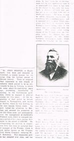
Document - CORNISH COLLECTION: PHOTOGRAPH OF HOME 'CARADON' (EAGLEHAWK) AND BOOKLET RE CARADON, CORNWALL
a. Photograph of home 'Caradon' (Eaglehawk) and booklet re Caradon, Cornwall. Home of John Hooper - front/side of two-storied brick building ''Eaglehawk's Civic Offices'' with information about Hooper and family; with separate copy of extract from book re detail of the life of John Hooper (with reproduction of portrait photo); b. 36 page booklet (Trades Directory) re the Caradon district in Cornwall- companies and services in south-east Cornwall (no date - but recent - 1960s??)buildings, house, caradon, mr j. hooper. caradon. cornish. trades directory. -
 Bendigo Historical Society Inc.
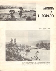
Document - MINING AT EL DORADO
Four page booklet describing some of the mines and mining techniques in the El Dorado district. The main two miines mentioned are the 'McEvoy' and the 'Cocks Pioneer' mines. The booklet was produced by the North Eastern Historical Society in 1968, Compiled by Colin AngusNorth Eastern Historical Societygold, goldfields, el dorado, gold mining, el dorado, cocks pioneer, mcevoy -
 Bendigo Historical Society Inc.
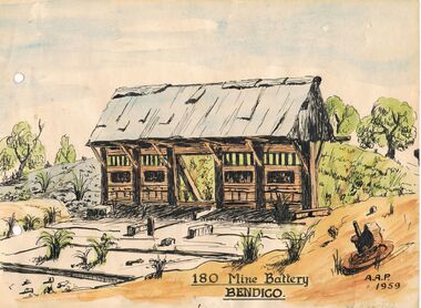
Painting - 180 MINE BATTERY
The remains of the 180 mine battery as painted by Alfred Perry in 1959. This is a watercolour and indian ink sketch on card. Yellow card attached with painting states: ' George Lansell Exhibit No 4. The remains of the 180 mine battery as painted by Alfred Perry in 1959. It was from the 180 that George Lansell laid the foundations of his fortune and indeed the fortunes of the district. With his capital behind the field mining flourished for nearly one hundred years and ensured employment for the many miners in the district.'Alfred Perryartwork, print, mining heritage, alfred perry, mining battery, 180 mine, victoria hill -
 Bendigo Historical Society Inc.
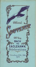
Book - BACK TO EAGLEHAWK OFFICIAL SOUVENIR
Souvenir of the Back to Eaglehawk celebrations, October 20 - 28th 1928. Includes a description of the district with photographs of important locations and people from the district, eg. Council. The book has a light blue cover with dark blue and gold printing, the pages are in black and white.event, back to, eaglehawk, souvenir, eaglehawk, back to eaglehawk -
 Bendigo Historical Society Inc.
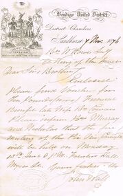
Document - ANCIENT ORDER OF FORESTERS NO. 3770 COLLECTION: CORRESPONDENCE
Letter from John Wal (the rest has been eaten by a silverfish) dated 7 Nov 1876. Letter mentions Voucher for £10 Funeral Benefit late Wife Bro Cowan. Also inform Bro Murray and Nicholas when the first meeting for the Pic Nic Committee will be held.societies, aof, correspondence, ancient order of foresters no. 3770 collection - correspondence, bendigo united district, court king of the forest, bro cowan, bro murray, bro nicholas, foresters hall myers st -
 Bendigo Historical Society Inc.
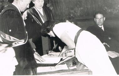
Photograph - LA TROBE UNIVERSITY BENDIGO COLLECTION: GRADUATION CEREMONY 1955
A black and white photograph of a student being presented to Mr. Ted Krieger District Inspector of Schools, at her Graduation Ceremony in 1955. Miss J.C. Burnett and Mr. Maurie Pratt are in the background. Name of student unknown.bendigo, education, bendigo teachers' college students, la trobe university bendigo collection, collection, bendigo teachers' college, bendigo, education, student, staff, graduation, bendigo teachers' college graduation, photo, photograph, photographs, photography, teacher training, tertiary education -
 Bendigo Historical Society Inc.
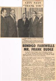
Newspaper - LA TROBE UNIVERSITY BENDIGO COLLECTION: MR FRANK BUDGE
A newspaper cutting with two headlines - (1) ' City says Thank you,' and ' Bendigo Farewells Mr. Frank Budge.' The article contains a photo with Mr. Budge at the reception talking with four men left to right, - Mayor Cr. D.E. Elliot, Director of General Education, Mr. F.H. Brooks, Mr. Budge, Director of Primary Education, Mr. R. F. Row and former Director of Education, Mr. R. P. McClellan. It also contains an outline of Mr. Budges work history and a comment on the civic reception given in his honour. The Bendigo ' Advertiser,' 27th November 1971.bendigo, education, mr. f. budge, la trobe university bendigo collection, collection, bendigo, education, mr. frank budge, district inspector, inspector, schools, primary schools, cr. d. e. elliott, mr. f. h. brooks, mr. r. f. row, mr. r. p. mcclellan, person, male, individual, bendigo teachers' college -
 Bendigo Historical Society Inc.
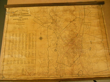
Map - STREET AND ROAD MAP OF THE CITY OF BENDIGO BOROUGH OF EAGLEHAWK AND SURROUNDING DISTRICTS
Heavy paper map with fabric backing. Timber piece attached at top, dowel attached to bottom. String in centre for hanging. Silver duct tape attached to top to secure map. Map shows streets of Bendigo and Eaglehawk. Written on map "Compiled by W.C. Harry 1946. Examined by J. Harry 1946."map, bendigo, bendigo and borough of eaglehawk -
 Bendigo Historical Society Inc.
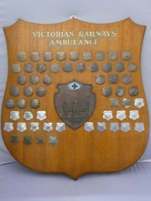
Award - VICTORIAN RAILWAYS AMBULANCE SHIELD, 1927
Wooden shield presented by the Victorian Railways Commissioners for annual Corps competition Northern District, light coloured timber with gold lettered heading, Victorian Railways Ambulance with a smaller copper shield in centre with blue enamel cartouche with red cross & a scene of stretcher bearers in relief, surrounded by small shields denoting the winners of competition from 1927 to 1983 reverse covered in green felt with a chromed hook.trophies & awards, sports, ambulance