Showing 2090 items
matching bendigo maps
-
 Bendigo Historical Society Inc.
Map - COLBINABBIN, June 1951
... Inc. History House 11 Mackenzie Street Bendigo goldfields MAP ...Map: Colbinabbin, County of Rodney. Parish planmap, rodney, parish plan, colbinabbin, county of rodney -
Bendigo Historical Society Inc.
Map - WHIRRAKEE, 1971
... Map: Whirrakee, County of Bendigo. Parish plan ( number 171... Inc. History House 11 Mackenzie Street Bendigo goldfields MAP ...Map: Whirrakee, County of Bendigo. Parish plan ( number 171 in Map Cupboard 1)map, bendigo, parish plan, whirrakee -
Bendigo Historical Society Inc.
Map - EPPALOCK, 15/11/1928
... Map: Eppalock, County of Bendigo. Parish plan ( number 170... Inc. History House 11 Mackenzie Street Bendigo goldfields MAP ...Map: Eppalock, County of Bendigo. Parish plan ( number 170 in Map Cupboard 1)map, bendigo, parish plan, eppalock -
Bendigo Historical Society Inc.
Map - EGERTON, 1/03/1890
... Map: Egerton, County of Bendigo. Parish plan ( number 169... Inc. History House 11 Mackenzie Street Bendigo goldfields MAP ...Map: Egerton, County of Bendigo. Parish plan ( number 169 in Map Cupboard 1)map, bendigo, parish plan, egerton -
Bendigo Historical Society Inc.
Map - HUNTLY, August 1945
... Map: Huntly, County of Bendigo, Parish plan ( number 168... Inc. History House 11 Mackenzie Street Bendigo goldfields MAP ...Map: Huntly, County of Bendigo, Parish plan ( number 168 in Map Cupboard 1)map, bendigo, parish plan, huntly, county of bendigo -
Bendigo Historical Society Inc.
Map - BAGSHOT, November 1948
... Map: Bagshot, County of Bendigo. Parish plan ( number 167... Inc. History House 11 Mackenzie Street Bendigo goldfields MAP ...Map: Bagshot, County of Bendigo. Parish plan ( number 167 in Map Cupboard 1)map, bendigo, parish plan, bagshot, county of bendigo -
Bendigo Historical Society Inc.
Map - LYELL, 16/04/1935
... Map: Lyell, County of Bendigo. Parish plan ( number 166... Inc. History House 11 Mackenzie Street Bendigo goldfields MAP ...Map: Lyell, County of Bendigo. Parish plan ( number 166 in Map Cupboard 1)map, bendigo, parish plan, lyell, county of bendigo -
Bendigo Historical Society Inc.
Map - LANGWORNOR, 17/07/1942
... Inc. History House 11 Mackenzie Street Bendigo goldfields MAP ...Map: Langwornor, County of Dalhousie. Parish Plan, coloured ( number 165 in Map Cupboard 1)map, dalhousie, parish plan, langwornor, county of dalhousie -
Bendigo Historical Society Inc.
Map - MARONG, June 1953
... Map: Marong, County of Bendigo. Parish plan ( number 164... Inc. History House 11 Mackenzie Street Bendigo goldfields MAP ...Map: Marong, County of Bendigo. Parish plan ( number 164 in Map Cupboard 1)map, bendigo, parish plan, marong, county of bendigo -
Bendigo Historical Society Inc.
Map - COSTERFIELD, 2/09/1939
... Inc. History House 11 Mackenzie Street Bendigo goldfields MAP ...Map: Costerfield, Counties of Dalhousie and Rodney. Parish plan ( number 163 in Map Cupboard 1)map, dalhousie, parish plan, costerfield, counties of dalhousie and rodney -
Bendigo Historical Society Inc.
Map - DARGILE, November 1953
... Inc. History House 11 Mackenzie Street Bendigo goldfields MAP ...Map: Dargile, County of Rodney. Parish plan ( number 162 in Map Cupboard 1)map, rodney, parish plan, dargile , county of rodney -
Bendigo Historical Society Inc.
Map - PARISH OF SANDHURST SHEET 5A, 1970
... Inc. History House 11 Mackenzie Street Bendigo goldfields MAP ...Map: Parish of Sandhurst Sheet 5A, County of Bendigo. Parish plan ( number 161 in Map Cupboard 1)map, bendigo, parish plan, parish of sandhurst, county of bendigo -
Bendigo Historical Society Inc.
Map - KOOYOORA, July 23rd 1857
... Inc. History House 11 Mackenzie Street Bendigo goldfields MAP ...Map: The Township of Kooyoora and suburban allotments in the Parish of Kingower. This plan has been applied to a newer backingmap, township, kooyoora, allotments, parish of kingower -
Bendigo Historical Society Inc.
Map - MANDURANG, 8/10/1887
... Inc. History House 11 Mackenzie Street Bendigo goldfields MAP ...Parish of Mandurang, County of Bendigo. Traced from a re-survey of the Parish of Mandurang by Mr. Geo. Black 8/10.1887 ( number 158 in Map Cupboard 1)map, bendigo, parish plan, mandurang, re-survey, couny of bendigo -
Bendigo Historical Society Inc.
Map - NEWSTEAD ALLOTMENTS, 10/06/1886
... Inc. History House 11 Mackenzie Street Bendigo goldfields MAP ...Map: Town ans Suburban Lots, Newstead, Parish of Strangwaysmap, allotments, newstead , allotments, parish of strangways -
 Bendigo Historical Society Inc.
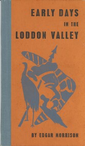
Book - EARLY DAYS IN THE LODDON VALLEY, 1966
Early days in the Loddon Valley, Memoirs of Edward Stone Parker 1802-1865, 98 Pages, with photographs and maps, Limited Edition of 1000 copies,Edgar Morrisonhistory, australian, loddon valley, history of loddon valley, castlemaine, daylesford, edward stone parker, aborigines, aboriginal stations -
 Bendigo Historical Society Inc.
Document - MCCOLL, RANKIN AND STANISTREET COLLECTION: SOUTH DEBORAH GOLD MINES NL, 1938-39
Documents: McColl, Rankin and Stanistreet: - documents in brown folder, label on top LH corner of manila folder : 'A.J. Moore - Reports etc. South Deborah Gold Mines' Folder contains: a). Report on proposal to form the South Deborah Co. signed by A.J. Moore, b) prospectus of South Deborah Gold Mines NL Deborah Reef, Bendigo, 1938, c). Letter to Secretary, Deborah Mines Co. d). Letter to E. Arnold, Manager, Deborah Gold Mines, e). Letter to A.J. Moore, f). Letter to A.J. Moore, g). Letter to James Mackay, h). Document headed South Deborah GM Co, I). Letter to A.,J. Moore Esq., letter to E,. Arnold, Manager Deborah Gold Mines NL, j). Letter to E. Arnold, Manager, Deborah Gold Mines NL. k). map of South Deborah Gold Mine NL.A.J. Mooreorganization, mining, south deborah gold mines nl, mccoll, rankin and stanistreet: south deborah gold mines nl, a.j. moore mining engineer, gold mining -
 Bendigo Historical Society Inc.
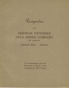
Document - MCCOLL, RANKIN AND STANISTREET COLLECTION: DEBORAH EXTENDED GOLD MINING COMPANY NL, 1940
McColl Rankin & Stanistreet, 12 Copies of Prospectus of Deborah Extended Gold Mining Company No Liability, Deborah Reef, Bendigo. To be incorporated under the Provisions of Part II, of the Companies Act 1938, Victoria. Application form and map of mines included in book form, dated 1940. Profit and Loss Account for Term ended 31st August, 1945 also included on separate sheet (has been folded in half across). Auditors: Wm. R. McKie & W. J. Sparkman.organization, mining, deborah extended gold mining cpy nl, mccoll rankin & stanistreet, deborah extended gold mining company nl, prospectus, profit and loss account for 31 august 1945, map of mine, form application -
 Bendigo Historical Society Inc.
Document - MCCOLL, RANKIN AND STANISTREET COLLECTION: ALICE PEEL GOLD MINING LEASE DOCUMENT, 8/7/1945
Document : McColl, Rankin and Stanistreet - gold mining lease document in name of Alice Peel, Executrix of Will of Edward Peel, deceased. 3 pages with map. No. 11198, Vol. 328., Fol. 36141. Lease crosses Houston Street, Quarry Hill. Transferred to South Deborah Gold Mines NL on 15/8/1946.organization, mining, south deborah gold mines nl, mccoll, rankin and stanistreet, alice peel, edward peel, gold mining lease, gold mining -
 Bendigo Historical Society Inc.
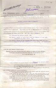
Document - MCCOLL, RANKIN AND STANISTREET COLLECTION: SOUTH DEBORAH GOLD MINES NL GOLD LEASE DOCUMENT, 14/1/1941
Document: McColl, Rankin and Stanistreet - South Deborah Gold Mines NL. Gold mining lease document. No. 11141, Vol. 325, Fol. 35893. Lease adjoins Railway Reserve, Breen Street. Attached to plan with pin piece of paper, written in pencil ' application Atherton 14/4/46 - consent refused - hand drawn map with Honeybone Street.organization, mining, south deborah gold mines nl, mccoll, rankin and stanistreet, south deborah gold mines nl, gold mining lease documents -
 Bendigo Historical Society Inc.
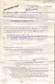
Document - MCCOLL, RANKIN AND STANISTREET COLLECTION: CENTRAL DEBORAH GOLD MINING COMPANY N/L GOLD MINING LEASE, 31 October 1950
Document: Central Deborah Gold Mining Company N/L gold mining lease. 4 page document with attached map. Map shows area from Breen Street to Victoria Street following the line of Old Violet Street.. Lease between Central Deborah Gold Mining Company N/L and the State of Victoria. No. 11230, Vol 331 Fol 36471.organization, mining, gold mining lease, central deborah gold mining company n/l; gold mining lease -
 Bendigo Historical Society Inc.
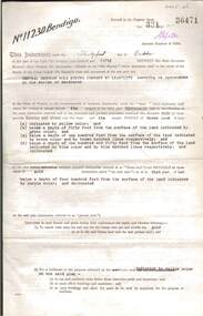
Document - MCCOLL, RANKIN AND STANISTREET COLLECTION: BENDIGO EXTENDED GOLD MINING COMPANY N/L MINING LEASE, 13 November 1956
Document: Bendigo Extended Gold Mining Company gold mining lease. 4 page document with attached map. Map shows area running roughly parallel to Adam Street, Quarry Hill. Lease between Bendigo Extended Gild Mining Co. N/L and State of Victoria. No. 11328, Vol 334 Fol 047.organization, mining, gold mining lease, bendigo extended gold mining co n/l; gold mining lease -
 Bendigo Historical Society Inc.
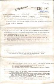
Document - MCCOLL, RANKIN AND STANISTREET COLLECTION: HERBERT JACKSON LEED OF BENDIGO, 1 April 1941
Document Herbert Jackson Leed document gold mining lease, Vol. 325 Fol. 35900, dated 1 April 1941. 4 page document with attached map and one unattached page. Map shows area in state Forest, Parish of Mandurang. Lease between Herbert Jackson Leed and State of Victoriaorganization, mining, gold mining lease, herbert jackson leed of bendigo, gold mining lease -
Bendigo Historical Society Inc.
Map - REDESDALE, See above
... Inc. History House 11 Mackenzie Street Bendigo goldfields MAP ...Map: two maps on either side of backing, (1) Township of Redesdale, Parish of Redesdale. (2) Surban lands, Parish of Spring Plains, County of Dalhousie. Date are 26th May 1873 and 12/07/1909 ( number 157 in Map Cupboard 1)map, dalhousie, township, redesdale, parish of spring plains, county of dalhousie -
Bendigo Historical Society Inc.
Map - MANDURANG, November 6th 1854
... Inc. History House 11 Mackenzie Street Bendigo goldfields MAP ...Map: The village of Mandurang situated about 6 miles from Sandhurst, Parish of Mandurang ( number 155 in Map Cupboard 1)map, bendigo, village, mandurang -
Bendigo Historical Society Inc.
Map - NEWSTEAD, 1/11/1939
... Inc. History House 11 Mackenzie Street Bendigo goldfields MAP ...Map: Town of Newstead, Parish of Strangways, County of Talbotmap, talbot, township, newstead, parish of strangways, county of talbot -
Bendigo Historical Society Inc.
Map - TARNAGULLA SHEET 3, No date Visible
... Inc. History House 11 Mackenzie Street Bendigo goldfields MAP ...Map: Tarnagulla Sheet 3, hand written on the side of the map. ( number 152 in Map Cupboard 1)map, parish plan, tarnagulla -
 Bendigo Historical Society Inc.
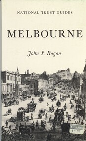
Book - NATIONAL TRUST GUIDES MELBOURNE, 1970
National Trust Guides Melbourne, 92 pages of descriptions, history and photographs of Melbourne heritage buildings with map.John P Roganhistory, melbourne, melbourne history, heritage buildings, national trust. -
 Bendigo Historical Society Inc.
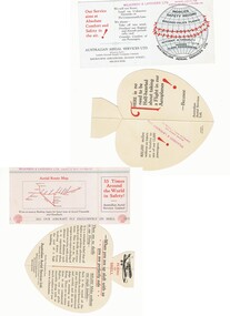
Document - BASIL WATSON COLLECTION: PUBLICITY CARDS FOR AUSTRALIAN AERIAL SERVICES LTD, c. 1930
Two publicity cards for Australian Aerial Services Ltd a. heart-shaped fold-out card highlighting the safety record of Australian Aerial Services Ltd. 'Flying with Shell' pop-out on card with image of bi-plane 'There is no need to be Half-hearted about taking a Flight in our Aeroplanes!When you are up aloft with us you are perfectly safe'; b. rectangular card highlighting safety record of AAS Ltd with aerial route map on reverse. Inside card: We will not stunt; Land on Unknown Grounds; or Fly unnecessarily Low. We always - Take off into wind; Overhaul our engines and aircraft periodically; and Consider comfort of our Passengers' Red stamp of 'Wilkinson & Lavender Ltd on back of card - Booking agents for Australian Aerial Services Ltd'business, transport, aviation -
Bendigo Historical Society Inc.
Map - TARNAGULLA SHEET 2, No date Visible
... Inc. History House 11 Mackenzie Street Bendigo goldfields MAP ...Map: Tarnagulla Sheet 2, Parish planmap, parish plan, tarnagulla