Showing 34304 items
matching c.1956
-
 Kew Historical Society Inc
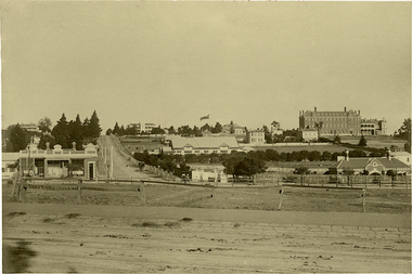
Photograph, J F C Farquhar, Wellington Street From High Street, 1891
At the beginning of the 1890s, the Kew businessman and Town Councillor, Henry Kellett, commissioned J.F.C. Farquhar to photograph scenes of Kew. These scenes included panoramas as well as pastoral scenes. The resulting set of twelve photographs was assembled in an album, Kew Where We Live, from which customers could select images for purchase.The preamble to the album describes that the photographs used the ‘argentic bromide’ process, now more commonly known as the gelatine silver process. This form of dry plate photography allowed for the negatives to be kept for weeks before processing, hence its value in landscape photography. The resulting images were considered to be finely grained and everlasting. Evidence of the success of Henry Kellett’s venture can be seen today, in that some of the photographs are held in national collections.It is believed that the Kew Historical Society’s copy of the Kellett album is unique and that the photographs in the book were the first copies taken from the original plates. It is the first and most important series of images produced about Kew. The individual images have proved essential in identifying buildings and places of heritage value in the district.Very few of the natural or built features in this panoramic photograph of Wellington Street remain. The open land between High Street South and Denmark Street, then known as O’Shannessy’s Paddock, was to become a residential subdivision at the beginning of the 20th Century. On the far side of Denmark Street, bordered by a picket fence, is the Kew Railway Station (demolished 1957). Further east, the large building with the flagpole is the Kew Recreation Hall (demolished 1960), which was the centre of civic life for almost a century. The building was used for dances, civic functions and exhibitions. A bowling green, tennis courts, and a cricket ground surrounded the Hall. The dominant building in the photograph is Xavier College, founded in 1872 by the Society of Jesus. The first classes for pupils were held in 1878. It is presumed that Farquhar used its roof for two of his bird’s eye views.Wellington Street from High Streetkew illustrated, kew where we live, photographic books, henry kellett -
 Kew Historical Society Inc
Photograph, J F C Farquhar, Studley Park Road, 1891
At the beginning of the 1890s, the Kew businessman and Town Councillor, Henry Kellett, commissioned J.F.C. Farquhar to photograph scenes of Kew. These scenes included panoramas as well as pastoral scenes. The resulting set of twelve photographs was assembled in an album, Kew Where We Live, from which customers could select images for purchase.The preamble to the album describes that the photographs used the ‘argentic bromide’ process, now more commonly known as the gelatine silver process. This form of dry plate photography allowed for the negatives to be kept for weeks before processing, hence its value in landscape photography. The resulting images were considered to be finely grained and everlasting. Evidence of the success of Henry Kellett’s venture can be seen today, in that some of the photographs are held in national collections.It is believed that the Kew Historical Society’s copy of the Kellett album is unique and that the photographs in the book were the first copies taken from the original plates. It is the first and most important series of images produced about Kew. The individual images have proved essential in identifying buildings and places of heritage value in the district.In this view of Studley Park Road, looking northeast to the Junction, the photographer invites the viewer to participate in a point-of-view that emphasises the elevated, tranquil vantage point of the hill in contrast to the bustling commercial area in the distance. The view emphasises the exclusiveness of Studley Park, with its high fences behind which a number of significant Kew mansions were concealed. Contemporary advertisements for the sale of mansions in Studley Park Road often included fulsome descriptions of their elaborate formal gardens, as well as paddocks for grazing, stabling and dairies. None can be seen here. The use of high, protective wooden pickets to surround the newly planted avenue of elms on the south side of the road appears to be typical of the period. Similar examples can be seen in early photographs of Wellington and Princess Streets.The horse and carriage, selected as a central focus of the view, reinforces the residential, exclusive nature of this part of Kew in the early 1890s. Studley Park Roadkew illustrated, kew where we live, photographic books, henry kellett -
 Kew Historical Society Inc
Photograph, J F C Farquhar, A View in Studley Park Road, 1891
At the beginning of the 1890s, the Kew businessman and Town Councillor, Henry Kellett, commissioned J.F.C. Farquhar to photograph scenes of Kew. These scenes included panoramas as well as pastoral scenes. The resulting set of twelve photographs was assembled in an album, Kew Where We Live, from which customers could select images for purchase.The preamble to the album describes that the photographs used the ‘argentic bromide’ process, now more commonly known as the gelatine silver process. This form of dry plate photography allowed for the negatives to be kept for weeks before processing, hence its value in landscape photography. The resulting images were considered to be finely grained and everlasting. Evidence of the success of Henry Kellett’s venture can be seen today, in that some of the photographs are held in national collections.It is believed that the Kew Historical Society’s copy of the Kellett album is unique and that the photographs in the book were the first copies taken from the original plates. It is the first and most important series of images produced about Kew. The individual images have proved essential in identifying buildings and places of heritage value in the district.This is the earliest known photograph of the exterior of Byram (later Tara Hall). It shows the original red brick fence, its asymmetrical gate and gateposts, with a large terra cotta gargoyle surmounting the higher of the two. The architect, Edward Kilburn designed Byram in the Arts & Crafts style for the industrialist George Ramsden. Construction began in 1888 and was reputed to have lasted three years. The mansion had frontages to Studley Park Road and Stevenson Street, including gardens laid out with great taste, including pleasure grounds, tennis lawn, fruit and flower garden, and paddock. The size of many of the trees in the garden indicate that many survived from the garden of Clifton Villa, the previous single-storeyed house built on the site by the Stevenson brothers. Byram had views to Melbourne and Port Phillip Bay. The house was demolished in 1960, despite opposition from the National Trust (Victoria), and its gardens subdivided into residential allotments.A View in Studley Park Roadkew illustrated, kew where we live, photographic books, henry kellett, byram, tara hall, goathlands -
 Kew Historical Society Inc
Photograph, J F C Farquhar, Railway Bridge Over the Yarra, 1891
At the beginning of the 1890s, the Kew businessman and Town Councillor, Henry Kellett, commissioned J.F.C. Farquhar to photograph scenes of Kew. These scenes included panoramas as well as pastoral scenes. The resulting set of twelve photographs was assembled in an album, Kew Where We Live, from which customers could select images for purchase.The preamble to the album describes that the photographs used the ‘argentic bromide’ process, now more commonly known as the gelatine silver process. This form of dry plate photography allowed for the negatives to be kept for weeks before processing, hence its value in landscape photography. The resulting images were considered to be finely grained and everlasting. Evidence of the success of Henry Kellett’s venture can be seen today, in that some of the photographs are held in national collections.It is believed that the Kew Historical Society’s copy of the Kellett album is unique and that the photographs in the book were the first copies taken from the original plates. It is the first and most important series of images produced about Kew. The individual images have proved essential in identifying buildings and places of heritage value in the district.Completed in November 1890, the railway viaduct (now the Chandler Highway Bridge) linked Kew and Fairfield. The viaduct is significant as the most substantial extant engineering remnant of the Outer Circle Railway Line. Opened in March 1891, the viaduct crossed the Yarra River in a single span, atop three supporting brick pillars. Following the closure of the railway line in 1927, and the construction of the Chandler Highway in 1930, the bridge was used for vehicular traffic. In 1891 when this panoramic photograph was taken, the grounds of what was then the Kew Lunatic Asylum extended down to the River and eastward beyond the viaduct. The landscape surrounding the Asylum was planted with traditional exotic trees such as Oaks, Pines and Cedars, and landmark trees from northern Australia such as the Hoop Pine. Remnant indigenous trees such as the River Red Gum, Yellow Box and Lightwood were scattered around the site, including beside the Yarra River.Railway Bridge Over the Yarrakew illustrated, kew where we live, photographic books, henry kellett, railway viaduct - - kew (vic) -
 Kew Historical Society Inc
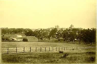
Photograph, J F C Farquhar, Kew Asylum & Grounds, 1891
At the beginning of the 1890s, the Kew businessman and Town Councillor, Henry Kellett, commissioned J.F.C. Farquhar to photograph scenes of Kew. These scenes included panoramas as well as pastoral scenes. The resulting set of twelve photographs was assembled in an album, Kew Where We Live, from which customers could select images for purchase.The preamble to the album describes that the photographs used the ‘argentic bromide’ process, now more commonly known as the gelatine silver process. This form of dry plate photography allowed for the negatives to be kept for weeks before processing, hence its value in landscape photography. The resulting images were considered to be finely grained and everlasting. Evidence of the success of Henry Kellett’s venture can be seen today, in that some of the photographs are held in national collections.It is believed that the Kew Historical Society’s copy of the Kellett album is unique and that the photographs in the book were the first copies taken from the original plates. It is the first and most important series of images produced about Kew. The individual images have proved essential in identifying buildings and places of heritage value in the district.When the Kew Lunatic Asylum was opened in 1871, its extensive 340 acres of grounds were intended for farming, agriculture and recreation for the inmates. The point-of-view chosen by Farquhar for this panoramic photograph focuses on the ordered open fields, haystacks and remnant trees that extended from the foreground to the rear of the Asylum. The inmates are the absent players in this pastoral idyll. In 1891, The Argus reported on the Annual Asylum Picnic: “Wednesday saw the Kew picnic, the yearly festival of the mad folks and their keepers. Once a year the public subscribes for cakes and ale for all these mad folks, and their keepers, from superintendent to lowest wardsman, turn out, and use their best endeavours to make one day in the year sanely merry.” Regardless of such merriment, the Asylum’s development and ongoing status were frequently a source of disquiet to the residents of Kew, who regularly petitioned the State Government for its removal. Despite these views, the Asylum was to remain a functioning institution from 1871 to 1988. Kew Asylum & Groundskew illustrated, kew where we live, photographic books, henry kellett, kew lunatic asylum -
 Kew Historical Society Inc
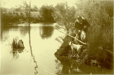
Photograph, J F C Farquhar, Ratting on the Yarra, 1891
At the beginning of the 1890s, the Kew businessman and Town Councillor, Henry Kellett, commissioned J.F.C. Farquhar to photograph scenes of Kew. These scenes included panoramas as well as pastoral scenes. The resulting set of twelve photographs was assembled in an album, Kew Where We Live, from which customers could select images for purchase.The preamble to the album describes that the photographs used the ‘argentic bromide’ process, now more commonly known as the gelatine silver process. This form of dry plate photography allowed for the negatives to be kept for weeks before processing, hence its value in landscape photography. The resulting images were considered to be finely grained and everlasting. Evidence of the success of Henry Kellett’s venture can be seen today, in that some of the photographs are held in national collections.It is believed that the Kew Historical Society’s copy of the Kellett album is unique and that the photographs in the book were the first copies taken from the original plates. It is the first and most important series of images produced about Kew. The individual images have proved essential in identifying buildings and places of heritage value in the district.In Farquhar’s close-up portrait of the rat catcher and his dog, the photographer excludes any extraneous data that otherwise might have provided a spatial or motivational context. The contemporary or the present day viewer is required to construct a narrative to explore or understand what is occurring. The title of the picture might incline a viewer to believe that what they see is an exercise in vermin control, and that the rat concerned might be an introduced black or brown rodent. A more likely scenario is that the rat catcher is focussed on catching ‘rakali’, a native water-rat once widely trapped for its fur. The trapping of rakali for use in the manufacture of fashionable clothing accelerated as introduced furs such as musquash became more expensive. It was not until 1938 that rakali were granted protected status.Ratting on the Yarrakew illustrated, kew where we live, photographic books, henry kellett, yarra river -
 Kew Historical Society Inc
Photograph, J F C Farquhar, Dight's Falls, 1891
At the beginning of the 1890s, the Kew businessman and Town Councillor, Henry Kellett, commissioned J.F.C. Farquhar to photograph scenes of Kew. These scenes included panoramas as well as pastoral scenes. The resulting set of twelve photographs was assembled in an album, Kew Where We Live, from which customers could select images for purchase.The preamble to the album describes that the photographs used the ‘argentic bromide’ process, now more commonly known as the gelatine silver process. This form of dry plate photography allowed for the negatives to be kept for weeks before processing, hence its value in landscape photography. The resulting images were considered to be finely grained and everlasting. Evidence of the success of Henry Kellett’s venture can be seen today, in that some of the photographs are held in national collections.It is believed that the Kew Historical Society’s copy of the Kellett album is unique and that the photographs in the book were the first copies taken from the original plates. It is the first and most important series of images produced about Kew. The individual images have proved essential in identifying buildings and places of heritage value in the district.Dight’s Falls in Studley Park is an artificial weir built on a natural rock bar across the Yarra. The weir was built in the 1840s to provide water to the ‘Ceres’ flour mill, one of the earliest industrial sites in Melbourne. The falls were later to be named after the owner of this mill. In 1888, William Guilfoyle, Director of the Melbourne Botanical Gardens had called for fresh water to be piped from above the weir to the Botanical Gardens, using a pumping station on the Kew side of the Falls, a holding reservoir in Walmer Street and a series of pipes from there to the Gardens. This system was opened in May 1891. Farquhar’s photograph of the man-made weir obscures the industrial activity on both sides of the Falls and focusses solely on the river and the surrounding natural vegetation. The photograph probably predates the disastrous flooding of the Yarra River in July 1891, the greatest to have occurred in the Colony since the foundation of Melbourne.Dight's Fallskew illustrated, kew where we live, photographic books, henry kellett, yarra river -
 Kew Historical Society Inc
Photograph, J F C Farquhar, The Yarra in Hyde Park, 1891
At the beginning of the 1890s, the Kew businessman and Town Councillor, Henry Kellett, commissioned J.F.C. Farquhar to photograph scenes of Kew. These scenes included panoramas as well as pastoral scenes. The resulting set of twelve photographs was assembled in an album, Kew Where We Live, from which customers could select images for purchase.The preamble to the album describes that the photographs used the ‘argentic bromide’ process, now more commonly known as the gelatine silver process. This form of dry plate photography allowed for the negatives to be kept for weeks before processing, hence its value in landscape photography. The resulting images were considered to be finely grained and everlasting. Evidence of the success of Henry Kellett’s venture can be seen today, in that some of the photographs are held in national collections.It is believed that the Kew Historical Society’s copy of the Kellett album is unique and that the photographs in the book were the first copies taken from the original plates. It is the first and most important series of images produced about Kew. The individual images have proved essential in identifying buildings and places of heritage value in the district.Hyde Park is now a small recreation reserve bordered by Willsmere and Kilby Roads and White Avenue. In 1982, Hyde Park was cut off from the Yarra River by the construction of the Eastern Freeway. The building of the latter was to transform the natural landscape, including the Yarra, as well as Hyde Park. The construction of the Freeway makes it difficult to view the scene with the photographer’s eye. Today’s Hyde Park is located on land purchased in 1847 by John Cowell, and in 1851 Catherine Cowell, yet the scene selected by the photographer may well have been located on farmland owned by the Wills family. Farquhar’s point-of-view emphasises both the pastoral and recreational elements of the scene: the grazing cows, three boys, and in the distance two figures, seated on the bank with a parasol. By 1891, an environmental consequence of human activity, including farming, was deforestation, leading to the erosion of the south bank of the Yarra. In contrast, the land on the Alphington side of the river in 1891 included remnant bushland.The Yarra in Hyde Parkkew illustrated, kew where we live, photographic books, henry kellett, yarra river -
 Tatura Irrigation & Wartime Camps Museum
Book, Professor Dr C. Hilty, Fur Schlaflose Nachte (Sleepless Nights), 1919
Used at Officer Camp, Dhurringile, during WW2.Linen finish cover, dark green, gold embossed, German text. 383 pages."Buecherei Offizierlager Dhurringile" stamped in red on flyleaf. Enc. greeting card - looses pages 384-385. B 8 70 in pencil on fly leaf. 2/6 in pencil.dhurringile, ww2, internment camps -
 Bayside Gallery - Bayside City Council Art & Heritage Collection
Work on paper - watercolour, John C. Paul, St. Ninian's servants' quarters, 1975
Built around 1841, St Ninian’s, located at 10 Miller Street, was one of Brighton’s earliest buildings. It is best known as being the home of merchant shipping agent, politician and former British naval officer, George Ward Cole between the 1840s and 1902. Following the death of George Ward Cole in 1879 and his wife in 1898, their only surviving child, Margaret, sold the property to Sir Thomas Bent, who subdivided the land in the early 1900s. The property was demolished in 1974. John C. Paul, St. Ninian's servants' quarters 1975, watercolour, 27.5 x 39.6 cm. Bayside City Council Art and Heritage Collectionst ninian's, brighton, historic house, george ward cole, thomas bent, servants' quarters -
 Bayside Gallery - Bayside City Council Art & Heritage Collection
Work on paper - watercolour, John C. Paul, St. Andrew's Brighton, 1971
St Andrew’s Anglican Church, located at 228 New St, Brighton, is the oldest continuous Anglican Church in Victoria. Opened on St Andrews day in 1842, it was one of the earliest Christian churches established in the Port Phillip District. A second church building was erected on the site in 1851, followed by a third building and schoolhouse in 1857 which was enlarged in 1886. A fire in 1961 engulfed the building and renowned Australian church architect Louis Williams was appointed to be the architect of the new building. The present church complex is amongst the largest church buildings in Australasia. Using over 500,000 bricks and over 16,000 roof tiles, this space consisted of three areas: the main church building, the Pioneer chapel and the Lady chapel. The large arcaded cloister, seen in this painting, with an internal cloister garden, is extremely rare in any church in Australasia, and links the Pioneer Chapel to the narthex of the new building.John C. Paul, St. Andrew's Brighton 1971, watercolour, 44 x 30.5 cm. Bayside City Council Art and Heritage Collection. Purchased 1974.brighton, john c paul, st andrews, church, anglican, cloister, arcade -
 Bayside Gallery - Bayside City Council Art & Heritage Collection
Work on paper - watercolour, John C. Paul, Old Building, 70 Carpenter Street, 1971
John C Paul, Old Building, 70 Carpenter Street 1971, watercolour, 28.5 x 40.8 cm. Bayside City Council Art and Heritage Collection. Purchased 1974.brighton, john c paul, historic house, carpenter street -
Clunes Museum
Map, PHOTO LITHOGRAPHED AT DEPT OF LANDS & SURVEY, MELBOURNE BY J NOONE. SURVEYED BY EDWARD C COMPTON 6TH SEPTEMBER 1872
MAP OF ALLOTMENTS IN CLUNESlocal history, documents, map, township, clunes -
Koorie Heritage Trust
Book, Billot, C. P. (Cecil Philip), John Batman : the story of John Batman and the founding of Melbourne, 1979
Founder of Melbourne no biography since 1867, the manner of his death may be the reason. Documentary works from a variety of primary sources in State libraries and Public Records have assisted in this work.xiii, 330 p., 8 p. of plates : ill., maps, ports. ; 24 cm.Founder of Melbourne no biography since 1867, the manner of his death may be the reason. Documentary works from a variety of primary sources in State libraries and Public Records have assisted in this work.batman, john, 1801-1839. | victoria. port phillip bay region. settlement. batman, john, 1801-1939. biographies. | land settlement -- victoria -- port phillip bay district. | port phillip bay region (vic.) -- history. -
Koorie Heritage Trust
Book, Billot, C. P, The life of our years; a pictorial chronology of Geelong, 1969
13-1190; ill. facs. photographs; maps; plates;geelong (vic.) -- history. | geelong region (vic.) -- history. -
Koorie Heritage Trust
Book, Billot, C. P, Geelong - Then and Now, 1969
39 p. : ill., 1 map ; 21 cm.geelong-history -
Koorie Heritage Trust
Book, Beauglehole, A. C, The distribution and conservation of vascular plants in the Gippsland Lakes hinterland area, Victoria, 1985
Col. map on 1 folded sheet in pocket. Bibliography: p. 9-10.botany -- victoria -- gippsland. -
Koorie Heritage Trust
Document - Printed Sheets, Beaglehole, J. C, The Endeavour Journal of Joseph Banks 1768-1771 Volume II
Figs.; maps; footnotes; 21 cm.australia-east coast (nsw) fauna and flora., australia-exploration. -
Koorie Heritage Trust
Document - Printed Sheets, Beauglehole, A . C, The distribution and conservation of native vascular plants in the Victorian Mallee, 1979
ii, 99 p. : ill., map (fold.col.in pocket) ; 21x30 cm.indigenous vascular plants. distribution. victoria. mallee region. | botany -- victoria -- mallee. -
Koorie Heritage Trust
Book, Beauglehole, A. C, The distribution and conservation of vascular plants in the Corangamite-Otway area, Victoria, 1980
ii,108p. : ill. ; 21x30cm. + 1 col.fold.map in pocket.indigenous vascular plants. distribution. south-west victoria. | botany -- victoria. -
Koorie Heritage Trust
Book, Beauglehole, A. C, The distribution and conservation of vascular plants in the Melbourne area, Victoria, 1983
iii, 156 p. : ill. ; 22 x 30 cm. + 1 folded col. map.indigenous vascular plants. distribution. melbourne region | botany -- victoria -- melbourne region. -
Koorie Heritage Trust
Book, Beauglehole, A. C, The Distribtion and Conservation of Vascular Plants in the South Gippsland area, Victoria, 1984
i-iii; 90 P.; fold-out map on end-cover; tables; maps; ill.; appendices.21 cm.south gippsland, vic.-fauna and flora. -
Koorie Heritage Trust
Book, Brockwell, C. J, Aborigines and the Law : a bibliography, 1979
This bibliography covers Aboriginal customary law, its interaction with the Australian legal system and the latter's relevance to the Aborigines. It has been assembled in three sections: Books and Articles; Statem Federal and Colonial Legislation; and Bibliographies and other aids.iii-vi; pp71; This bibliography covers Aboriginal customary law, its interaction with the Australian legal system and the latter's relevance to the Aborigines. It has been assembled in three sections: Books and Articles; Statem Federal and Colonial Legislation; and Bibliographies and other aids.australia. law. implications for australian aborigines. bibliographies. | aboriginal australians -- legal status, laws, etc. -- bibliography. | law -- australia -- bibliography. -
Koorie Heritage Trust
Book, Billot, C. P, Melbourne : an annotated bibliography to 1850, 1970
Every printed item on Melbourne to 1850 the author could trace together with notes and cross-references tp build a picture of Melbourne to 1850. Melbourne-bibliographies - 1850. Facsimile of the Batman Treaty. Facsimile of the proclamation of Victoria becoming a separate state.i-iv; 307 p.; appendices; index; 24 cm.Every printed item on Melbourne to 1850 the author could trace together with notes and cross-references tp build a picture of Melbourne to 1850. Melbourne-bibliographies - 1850. Facsimile of the Batman Treaty. Facsimile of the proclamation of Victoria becoming a separate state.victoria -- history. | victoria -- melbourne. | melbourne (vic.) -- imprints. | melbourne (vic.) -- bibliography. -
Koorie Heritage Trust
Book, Beauglehole, A. C, The distribution and conservation of vascular plants in the north central area, Victoria, 1982
iv, 102 p. : ill., maps ; 22 x 30 cm. + 1 col. folded map.indigenous vascular plants. distribution. northern victoria | botany -- victoria. -
Koorie Heritage Trust
Book, Beauglehole, A. C, The distribution and conservation of vascular plants in the south west area, Victoria, 1984
iv, 124 p. : ill., maps (some col.) ; 21 x 29 cm.botany -- victoria, southwestern. -
Koorie Heritage Trust
Book, Beauglehole, A. C, The distribution and conservation of vascular plants in the East Gippsland area, Victoria, 1981
iv, 124 p. : ill., maps (some col.) ; 22 x 30 cm.indigenous vascular plants. distribution. victoria. gippsland. | botany -- victoria -- gippsland. -
Koorie Heritage Trust
Book, Beauglehole, A. C, The distribution and conservation of vascular plants in the Ballarat area, Victoria, 1983
iv, 94 p. : ill. ; 22 x 30 cm. + 1 folded col. map.indigenous vascular plants. distribution. victoria. ballarat region. | botany -- victoria -- ballarat region. -
Koorie Heritage Trust
Book, Beauglehole, A. C, The distribution and conservation of vascular plants in the alpine area, Victoria, 1981
One col. map on folded leaf in pocket. Bibliography: p. 9-11.indigenous vascular plants. distribution. victoria. alpine regions | botany -- victoria. -
Koorie Heritage Trust
Book, C. E. Sayers (Original edition edited by Bride, Thomas Francis), Letters from Victorian pioneers : a series of papers on the early occupation of the colony, the Aborigines, etc. addressed by Victorian pioneers to His Excellency Charles Joseph La Trobe, Esq., Lieutenant-Governor of the Colony of Victoria, 1983
Brief notes on the contributors and incidents have been included in this edition although the above-mentioned items have been left out, some marginal notes made by Governor La Trobe have been dealt with in the footnotes. "From the original edition edited for the Trustees of the Public Library by Thomas Francis Bride'. Previously published: Melbourne : Heinemann, 1969. Originally published: Melbourne : Government Printer for the Trustees of the Public Library, Museums and National Gallery of Victoria, 1898.xiv, 455 p., 31 p. of plates : map ; 26 cm.Brief notes on the contributors and incidents have been included in this edition although the above-mentioned items have been left out, some marginal notes made by Governor La Trobe have been dealt with in the footnotes. "From the original edition edited for the Trustees of the Public Library by Thomas Francis Bride'. Previously published: Melbourne : Heinemann, 1969. Originally published: Melbourne : Government Printer for the Trustees of the Public Library, Museums and National Gallery of Victoria, 1898.pioneering, 1836-1854. victoria. correspondence, diaries, etc. | victoria. description & travel, 1836-1854. correspondence, diaries, etc. | frontier and pioneer life -- victoria. | victoria -- history -- 1834-1900 -- sources. | victoria -- description and travel -- 1851-1900.