Showing 2380 items
matching first place
-
 Ballarat Heritage Services
Photograph - Colour, Earth Banks, Old Sarum, England, 2016, 01 November 2016
William the Conqueror inherited Old Sarum from the last Saxon king of England. It was an ideal site for a royal castle. It was here in 1070 that William paid off his army after a long and bitter campaign in northern England. It was here in 1086 that he called together all the major landholders in England so they could swear allegiance to him. It was a crucial moment. The Domesday Book was being written, a threatened Viking invasion had only just been averted and William's eldest son was in armed rebellion. Old Sarum was an important place where this Norman king of England held power. In 1794 the Ordnance Survey set out to check the accuracy of the first mapping of Southern England, which had begun ten years earlier. From a point just below Old Sarum Lieutenant William Mudge laid out a base-line 36,574 feet (11,253 metres) long. From each end of the line the positions of distant places were plotted using a huge theodolite made in 1791 by Jesse Ramsden. The accuracy of the process, which was repeated all over England, depended on Jesse Ramsden's craftsmanship and on William Mudge's surveying skill in setting out this first base-line from Old Sarum. The nearer end of Mudge's line is marked by an inscribed stone beside the modern A345 at Old Sarum. ordnance survey, william mudge, jesse ramsden, william the conqueror, old sarum, saxon, 1086, england -
 Ballarat Heritage Services
Photograph - Photograph - Colour, Castle toilets, Old Sarum, England, 2016, 01/11/2016
William the Conqueror inherited Old Sarum from the last Saxon king of England. It was an ideal site for a royal castle. It was here in 1070 that William paid off his army after a long and bitter campaign in northern England. It was here in 1086 that he called together all the major landholders in England so they could swear allegiance to him. It was a crucial moment. The Domesday Book was being written, a threatened Viking invasion had only just been averted and William's eldest son was in armed rebellion. Old Sarum was an important place where this Norman king of England held power. In 1794 the Ordnance Survey set out to check the accuracy of the first mapping of Southern England, which had begun ten years earlier. From a point just below Old Sarum Lieutenant William Mudge laid out a base-line 36,574 feet (11,253 metres) long. From each end of the line the positions of distant places were plotted using a huge theodolite made in 1791 by Jesse Ramsden. The accuracy of the process, which was repeated all over England, depended on Jesse Ramsden's craftsmanship and on William Mudge's surveying skill in setting out this first base-line from Old Sarum. The nearer end of Mudge's line is marked by an inscribed stone beside the modern A345 at Old Sarum. Colour photographs of Castle toilets at Old Sarum, England. The toilets are constructed of stone. ordnance survey, william mudge, jesse ramsden, william the conqueror, old sarum, saxon, 1086, england, subjects, toilets -
 Ballarat Heritage Services
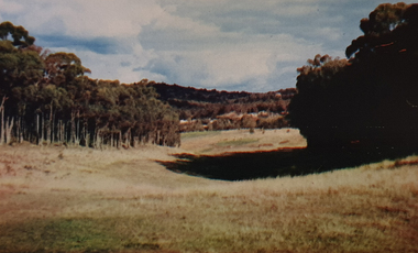
Photograph, Nucolorvue, First Fairway of Golf Course, Hepburn, 1957
Daylesford is a tourist town in Central Victorian, known for its mineral water springs.The first course at the Hepburn Golf Club.Daylesford, Victoria, Australia This famous holiday resort is famous for its up-to-date facilities, as well as for its natural attractions. The mineral Springs are renowned for their high medicinal elements. The visitor finds ample to amuse, in excellent fishing, boating, Boating, Swimming, golfing, hiking and riding. The district provides a wide range of typical Australian bush scenery, and the altitude of 2,000 feet above sea level as a tonic effect on all. Daylesford has modern hotels, guest houses, shops and places of amusement, also many other places of interest within short travelling distance. Bendigo, 50 miles, Ballara 30 miles, and Melbourne 75 miles, bring Daylesford within easy reach of many parts of Victoria. daylesford, fairway, hepburn golf course -
 Ballarat Heritage Services
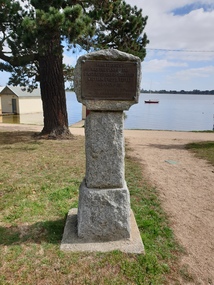
Photograph - Boathouse, Clare Gervasoni, Cairn displaying the place were William Cross Yuille Camped, 2021
Lake Wendouree was originally known as Yuille's Swamp.Colour photograph of a cairn displaying the place were William Cross Yuille CampedNear this spot was the camp of the first resident of Ballarat William Cross Yuille in March 1938. Presented by Cr A.J. Darling. Mayor of Ballarat 1034. Ballt Historical Socylake wendouree, william cross yuille, a.j. darling, yuille's swamp, marker -
 Ballarat Heritage Services
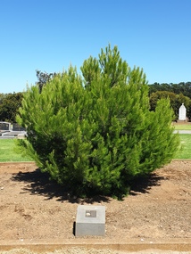
Photograph - Photograph - Colour, Clare Gervasoni, Aleppo Pine, Tower Hill Cemetery, 2019, 03/01/2019
The Tower Hill Cemetery is located near Koroit on the north side of the Princes Highway The, between Port Fairy and Warrnambool. The first burial at Tower Hill Cemetery took place in 1856. Over 150 years there has been over 8,000 burials. Around 45 percent of the burials are in unmarked graves. In 2023 this tree was no longer in existence, and a smaller tree was struggling in this site.Colour photographs of an Aleppo Pine planted in the Tower Hill Cemetery to mark the centenary of the landing at Galipolli.aleppo pine, anzac centenary, centenary, anniversary, tower hill cemetery, gallipoli -
 Ballarat Heritage Services
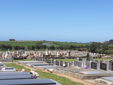
Photograph - Photograph - Colour, Clare Gervasoni, Tower Hill Cemetery, 2019, 03/01/2019
The Tower Hill Cemetery is located near Koroit on the north side of the Princes Highway The, between Port Fairy and Warrnambool. The first burial at Tower Hill Cemetery took place in 1856. Over 150 years there has been over 8,000 burials. Around 45 percent of the burials are in unmarked graves. Colour photograph of the Tower Hill Cemetery. with potatoes being irrigated in te background. The cemetery is laid out on design of a Celtic Cross.tower hill cemetery, tower hill, cemetery -
 Ballarat Heritage Services
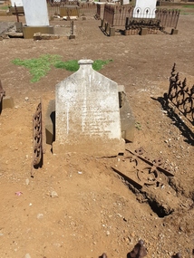
Photograph - Photograph - Colour, Clare Gervasoni, Headstone of Patrick Carroll in Tower Hill Cemetery, 2019, 03/01/2019
The Tower Hill Cemetery is located near Koroit on the north side of the Princes Highway The, between Port Fairy and Warrnambool. The first burial at Tower Hill Cemetery took place in 1856. Over 150 years there has been over 8,000 burials. Around 45 percent of the burials are in unmarked graves.Colour photograph of the headstone of Patrick Carroll in the Tower Hill Cemetery. . by Patrick Carroll InLoving Remembrance of my beloved son Patrick Who departed this life the 20th day of April 1874 Aged 2 years and 2 months Also his beloved mother Who departed this life 15th Sept 1876 Aged 74 years Also his who died 16th November 1890 Aged 89 Years Also Patrick Carroll Who died 10 July 1906 aged 72 years Rest in Peace tower hill cemetery, patrick carroll -
 Ballarat Heritage Services
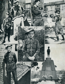
Photograph, Henri (unofficial AIF Mascot), c1918
During World War One Tim Tovell of the No. 4 Squadron RAAF befriended a French orphan known as Henri or Digger. The child became an unofficial mascot, was given a custom made AIF uniform, and at the end of the war was smuggled back to Australia. As an adult Henri was killed in a car accident and is buried at Fawkner Cemetery, Victoria. Members of the No 4 Squadron subscribed for a memorial stone.Five black and white image. Top Left, Digger and his adopted father Tim Tovell, and the oats bagged he was smuggled in. Top right: Defence training at Hurdcott. Centre: Henri as an unofficial member of the AIF. Bottom left: Henri as a member of the RAAF. Bottom right: The last resting place of Henri/Digger at Fawkner Cemetery. The statue depicts Henri as he was when he first came to the 4th squadron. henri, digger, aif, raaf, tim tovell, no 4 squadron, fawkner cemetery, world war one, flight, aeroplane, hurdcott -
 Ballarat Heritage Services
Photograph - Colour, Toilets, Old Sarum, England, English Heritage Site, 2016, 01 November 2016
William the Conqueror inherited Old Sarum from the last Saxon king of England. It was an ideal site for a royal castle. It was here in 1070 that William paid off his army after a long and bitter campaign in northern England. It was here in 1086 that he called together all the major landholders in England so they could swear allegiance to him. It was a crucial moment. The Domesday Book was being written, a threatened Viking invasion had only just been averted and William's eldest son was in armed rebellion. Old Sarum was an important place where this Norman king of England held power. In 1794 the Ordnance Survey set out to check the accuracy of the first mapping of Southern England, which had begun ten years earlier. From a point just below Old Sarum Lieutenant William Mudge laid out a base-line 36,574 feet (11,253 metres) long. From each end of the line the positions of distant places were plotted using a huge theodolite made in 1791 by Jesse Ramsden. The accuracy of the process, which was repeated all over England, depended on Jesse Ramsden's craftsmanship and on William Mudge's surveying skill in setting out this first base-line from Old Sarum. The nearer end of Mudge's line is marked by an inscribed stone beside the modern A345 at Old Sarum. ordnance survey, william mudge, jesse ramsden, william the conqueror, old sarum, saxon, 1086, england -
 Ballarat Heritage Services
Photograph - Colour, Stonework, Old Sarum, England, English Heritage Site, 2016, 01 November 2016
William the Conqueror inherited Old Sarum from the last Saxon king of England. It was an ideal site for a royal castle. It was here in 1070 that William paid off his army after a long and bitter campaign in northern England. It was here in 1086 that he called together all the major landholders in England so they could swear allegiance to him. It was a crucial moment. The Domesday Book was being written, a threatened Viking invasion had only just been averted and William's eldest son was in armed rebellion. Old Sarum was an important place where this Norman king of England held power. In 1794 the Ordnance Survey set out to check the accuracy of the first mapping of Southern England, which had begun ten years earlier. From a point just below Old Sarum Lieutenant William Mudge laid out a base-line 36,574 feet (11,253 metres) long. From each end of the line the positions of distant places were plotted using a huge theodolite made in 1791 by Jesse Ramsden. The accuracy of the process, which was repeated all over England, depended on Jesse Ramsden's craftsmanship and on William Mudge's surveying skill in setting out this first base-line from Old Sarum. The nearer end of Mudge's line is marked by an inscribed stone beside the modern A345 at Old Sarum. ordnance survey, william mudge, jesse ramsden, william the conqueror, old sarum, saxon, 1086, england -
 Ballarat Heritage Services
Photograph - Colour, looking from Stonework towards earth mounds, Old Sarum, England, English Heritage Site, 2016, 01 November 2016
William the Conqueror inherited Old Sarum from the last Saxon king of England. It was an ideal site for a royal castle. It was here in 1070 that William paid off his army after a long and bitter campaign in northern England. It was here in 1086 that he called together all the major landholders in England so they could swear allegiance to him. It was a crucial moment. The Domesday Book was being written, a threatened Viking invasion had only just been averted and William's eldest son was in armed rebellion. Old Sarum was an important place where this Norman king of England held power. In 1794 the Ordnance Survey set out to check the accuracy of the first mapping of Southern England, which had begun ten years earlier. From a point just below Old Sarum Lieutenant William Mudge laid out a base-line 36,574 feet (11,253 metres) long. From each end of the line the positions of distant places were plotted using a huge theodolite made in 1791 by Jesse Ramsden. The accuracy of the process, which was repeated all over England, depended on Jesse Ramsden's craftsmanship and on William Mudge's surveying skill in setting out this first base-line from Old Sarum. The nearer end of Mudge's line is marked by an inscribed stone beside the modern A345 at Old Sarum. ordnance survey, william mudge, jesse ramsden, william the conqueror, old sarum, saxon, 1086, england -
 Ballarat Heritage Services
Photograph - Colour, Looking from Stonework towards people walking on earth mounds, Old Sarum, England, English Heritage Site, 2016, 01 November 2016
William the Conqueror inherited Old Sarum from the last Saxon king of England. It was an ideal site for a royal castle. It was here in 1070 that William paid off his army after a long and bitter campaign in northern England. It was here in 1086 that he called together all the major landholders in England so they could swear allegiance to him. It was a crucial moment. The Domesday Book was being written, a threatened Viking invasion had only just been averted and William's eldest son was in armed rebellion. Old Sarum was an important place where this Norman king of England held power. In 1794 the Ordnance Survey set out to check the accuracy of the first mapping of Southern England, which had begun ten years earlier. From a point just below Old Sarum Lieutenant William Mudge laid out a base-line 36,574 feet (11,253 metres) long. From each end of the line the positions of distant places were plotted using a huge theodolite made in 1791 by Jesse Ramsden. The accuracy of the process, which was repeated all over England, depended on Jesse Ramsden's craftsmanship and on William Mudge's surveying skill in setting out this first base-line from Old Sarum. The nearer end of Mudge's line is marked by an inscribed stone beside the modern A345 at Old Sarum. ordnance survey, william mudge, jesse ramsden, william the conqueror, old sarum, saxon, 1086, england -
 Ballarat Heritage Services
Photograph - Colour, Stairs, Old Sarum, England, English Heritage Site, 2016, 01 November 2016
William the Conqueror inherited Old Sarum from the last Saxon king of England. It was an ideal site for a royal castle. It was here in 1070 that William paid off his army after a long and bitter campaign in northern England. It was here in 1086 that he called together all the major landholders in England so they could swear allegiance to him. It was a crucial moment. The Domesday Book was being written, a threatened Viking invasion had only just been averted and William's eldest son was in armed rebellion. Old Sarum was an important place where this Norman king of England held power. In 1794 the Ordnance Survey set out to check the accuracy of the first mapping of Southern England, which had begun ten years earlier. From a point just below Old Sarum Lieutenant William Mudge laid out a base-line 36,574 feet (11,253 metres) long. From each end of the line the positions of distant places were plotted using a huge theodolite made in 1791 by Jesse Ramsden. The accuracy of the process, which was repeated all over England, depended on Jesse Ramsden's craftsmanship and on William Mudge's surveying skill in setting out this first base-line from Old Sarum. The nearer end of Mudge's line is marked by an inscribed stone beside the modern A345 at Old Sarum. ordnance survey, william mudge, jesse ramsden, william the conqueror, old sarum, saxon, 1086, england -
 Ballarat Heritage Services
Photograph - Colour, Public toilets hidden in earth mound, Old Sarum, England, English Heritage Site, 2016, 01 November 2016
William the Conqueror inherited Old Sarum from the last Saxon king of England. It was an ideal site for a royal castle. It was here in 1070 that William paid off his army after a long and bitter campaign in northern England. It was here in 1086 that he called together all the major landholders in England so they could swear allegiance to him. It was a crucial moment. The Domesday Book was being written, a threatened Viking invasion had only just been averted and William's eldest son was in armed rebellion. Old Sarum was an important place where this Norman king of England held power. In 1794 the Ordnance Survey set out to check the accuracy of the first mapping of Southern England, which had begun ten years earlier. From a point just below Old Sarum Lieutenant William Mudge laid out a base-line 36,574 feet (11,253 metres) long. From each end of the line the positions of distant places were plotted using a huge theodolite made in 1791 by Jesse Ramsden. The accuracy of the process, which was repeated all over England, depended on Jesse Ramsden's craftsmanship and on William Mudge's surveying skill in setting out this first base-line from Old Sarum. The nearer end of Mudge's line is marked by an inscribed stone beside the modern A345 at Old Sarum. ordnance survey, william mudge, jesse ramsden, william the conqueror, old sarum, saxon, 1086, england -
 Ballarat Heritage Services
Photograph - Colour, Entrance to Public toilets hidden in earth mound, Old Sarum, England, English Heritage Site, 2016, 01 November 2016
William the Conqueror inherited Old Sarum from the last Saxon king of England. It was an ideal site for a royal castle. It was here in 1070 that William paid off his army after a long and bitter campaign in northern England. It was here in 1086 that he called together all the major landholders in England so they could swear allegiance to him. It was a crucial moment. The Domesday Book was being written, a threatened Viking invasion had only just been averted and William's eldest son was in armed rebellion. Old Sarum was an important place where this Norman king of England held power. In 1794 the Ordnance Survey set out to check the accuracy of the first mapping of Southern England, which had begun ten years earlier. From a point just below Old Sarum Lieutenant William Mudge laid out a base-line 36,574 feet (11,253 metres) long. From each end of the line the positions of distant places were plotted using a huge theodolite made in 1791 by Jesse Ramsden. The accuracy of the process, which was repeated all over England, depended on Jesse Ramsden's craftsmanship and on William Mudge's surveying skill in setting out this first base-line from Old Sarum. The nearer end of Mudge's line is marked by an inscribed stone beside the modern A345 at Old Sarum. ordnance survey, william mudge, jesse ramsden, william the conqueror, old sarum, saxon, 1086, england -
 Ballarat Heritage Services
Photograph - Colour, Masons' Marks, Old Sarum, England, English Heritage Site, 2016, 01 November 2016
William the Conqueror inherited Old Sarum from the last Saxon king of England. It was an ideal site for a royal castle. It was here in 1070 that William paid off his army after a long and bitter campaign in northern England. It was here in 1086 that he called together all the major landholders in England so they could swear allegiance to him. It was a crucial moment. The Domesday Book was being written, a threatened Viking invasion had only just been averted and William's eldest son was in armed rebellion. Old Sarum was an important place where this Norman king of England held power. In 1794 the Ordnance Survey set out to check the accuracy of the first mapping of Southern England, which had begun ten years earlier. From a point just below Old Sarum Lieutenant William Mudge laid out a base-line 36,574 feet (11,253 metres) long. From each end of the line the positions of distant places were plotted using a huge theodolite made in 1791 by Jesse Ramsden. The accuracy of the process, which was repeated all over England, depended on Jesse Ramsden's craftsmanship and on William Mudge's surveying skill in setting out this first base-line from Old Sarum. The nearer end of Mudge's line is marked by an inscribed stone beside the modern A345 at Old Sarum. ordnance survey, william mudge, jesse ramsden, william the conqueror, old sarum, saxon, 1086, england -
 Ballarat Heritage Services
Photograph - Colour, Masons' Marks, Old Sarum, England, English Heritage Site, 01 November 2016
William the Conqueror inherited Old Sarum from the last Saxon king of England. It was an ideal site for a royal castle. It was here in 1070 that William paid off his army after a long and bitter campaign in northern England. It was here in 1086 that he called together all the major landholders in England so they could swear allegiance to him. It was a crucial moment. The Domesday Book was being written, a threatened Viking invasion had only just been averted and William's eldest son was in armed rebellion. Old Sarum was an important place where this Norman king of England held power. In 1794 the Ordnance Survey set out to check the accuracy of the first mapping of Southern England, which had begun ten years earlier. From a point just below Old Sarum Lieutenant William Mudge laid out a base-line 36,574 feet (11,253 metres) long. From each end of the line the positions of distant places were plotted using a huge theodolite made in 1791 by Jesse Ramsden. The accuracy of the process, which was repeated all over England, depended on Jesse Ramsden's craftsmanship and on William Mudge's surveying skill in setting out this first base-line from Old Sarum. The nearer end of Mudge's line is marked by an inscribed stone beside the modern A345 at Old Sarum. ordnance survey, william mudge, jesse ramsden, william the conqueror, old sarum, saxon, 1086, england -
 Ballarat Heritage Services
Photograph - Colour, Masons' Marks, Old Sarum, England, English Heritage Site, 2016, 01 November 2016
William the Conqueror inherited Old Sarum from the last Saxon king of England. It was an ideal site for a royal castle. It was here in 1070 that William paid off his army after a long and bitter campaign in northern England. It was here in 1086 that he called together all the major landholders in England so they could swear allegiance to him. It was a crucial moment. The Domesday Book was being written, a threatened Viking invasion had only just been averted and William's eldest son was in armed rebellion. Old Sarum was an important place where this Norman king of England held power. In 1794 the Ordnance Survey set out to check the accuracy of the first mapping of Southern England, which had begun ten years earlier. From a point just below Old Sarum Lieutenant William Mudge laid out a base-line 36,574 feet (11,253 metres) long. From each end of the line the positions of distant places were plotted using a huge theodolite made in 1791 by Jesse Ramsden. The accuracy of the process, which was repeated all over England, depended on Jesse Ramsden's craftsmanship and on William Mudge's surveying skill in setting out this first base-line from Old Sarum. The nearer end of Mudge's line is marked by an inscribed stone beside the modern A345 at Old Sarum. ordnance survey, william mudge, jesse ramsden, william the conqueror, old sarum, saxon, 1086, england -
 Ballarat Heritage Services
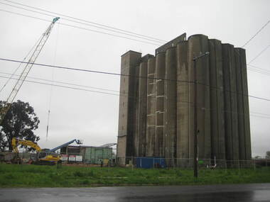
Photograph - Photograph - Colour, Lisa Gervasoni, Joe White Maltings Silos Under Demolition, 2010, 15/10/2010
"A plan to turn the Gregory Street silos into apartments is no more.Developers Eleveno Pty Ltd have abandoned plans to transform the Lake Wendouree silos into a giant apartment complex, despite previously being given the green light from the Victorian Civil and Administrative Tribunal.Director Richard Sykes yesterday confirmed the silos would be demolished."The plans are not proceeding. The plan now is to create residential houses," he said.The planning permit for an 18-lot subdivision was approved by Ballarat City Council on July 22, despite objections lodged against the application.Mr Sykes said it wasn't feasible to turn the silos into 27 units and there were many factors behind the decision."They're being demolished for various reasons, there were just better solutions," he said.Bold plans to transform the former Joe White Maltings silos into apartments were first submitted to Ballarat City Council in January 2007.However, developers took the proposal to VCAT in September 2008 after council failed to make a decision in the required 60-day timeframe.A hearing was held in early 2009 and the development was approved in March last year.Mr Sykes said it was found that the building would most likely be out of place in the region."We found the market didn't really want that sort of development," he said."They're probably more suited for inner-city development, rather than regional areas."Mr Sykes did not put a price on either the proposed development or the demolition, but said it would "cost a fair amount of money".He said once the demolition permit has been passed, works were expected to begin in November." (Ballarat Courier, 03 August 2010)Joe White Maltings Silos in Gregory Street Ballarat under demolition, to make way for a housing development. The silos were built on the banks of Lake Wendouree. joe white maltings, silo, eleveno pty ltd, lake wendouree, demolition, gregory street ballarat, wendouree parade, architecture -
 Ballarat Heritage Services
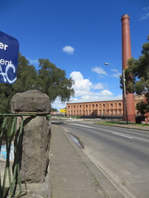
Photograph - Photograph - Colour, Sunnyside Mill Bridge over the Yarrowee, Hill Street, Ballarat, 2016, 17/09/2016
"A joint meeting of city and town ratepayers, convened by Messrs Francis Jago and Henry Johns, interested in the formation of a cart bridge in Hill street, over the Yarrowee Creek, was held on Saturday evening, in the Societies Hall, corner of Skipton and South streets, with the view of taking united action in the matter. Mr Morris was voted to the chair, : and about 60 persons were present. The chairman stated that the object of the meeting was that united influence should be brought to bear upon the City and Town Councils, so that a cartbridge should be erected. He said that Mount Pleasant would no doubt be thickly populated in a few years, and the bridge would prove a great boon to the inhabitants of the locality. By means of a cart bridge drays, would be enabled to save on their journeys to and fro between the mount and the batteries, at least a mile and a half each time. He hoped that the councillors for the south ward would assist them in this matter. Mr Jago, as one of the conveners of the meeting, said that united action on the part of both eastern and western ratepayers was requisite, so as to exert a strong pressure upon the City and Town Councils, in order that the work should be carried but. Mr Grainger moved the first resolution as follows;—“ That the construction of a cart bridge over the Yarrowee Creek at Sunnyside, to facilitate communication between the residents of the city and town, is urgently necessary, and that in the interests of both municipalities the two councils be asked to at once jointly carry out the work. In doing so he said that the necessity of a cart-bridge for the residents of Mount Pleasant would be apparent when the number of batteries, tanneries, and also the Woollen Mill, in the district were considered. The place was of growing import ance, and ready communication should at once be established. Another reason was that an immense saving in time would be effected. It was quite a common occurrence to see one, two, or three drays stuck in the bed of the creek which had gone that way to make a short cut. Now, what with the horses floundering about and breaking their harness, it seemed a wonder to him that life had not been destroyed before now, just through the want of a cartbridge. Mr Johns seconded the resolution. Mr Robert Calvert supported the resolution, and said that it was disgraceful action on the part of the representatives of the south ward that the work had not been executed long ago. They should come together like men and demand that the work should be done, and if not done they should not pay rates until it was. (A voice—“But they’ll make us.” Laughter.) The wooden footbridge across the creek was “only a wooden fabric, not fit for a Christian to walk across, and steps should be taken to remedy this also. Mr Blight, a resident of Mount Pleasant, said that, in common with others, he had been opposed to the erection of the bridge two years ago, but his views had since been altered. Cr. Morrison, who was present, said that the fault of the cartbridge not being erected over the Yarrowee at Hill street lay not with the City Council, but with their neighbors, who had always been opposed to its erection there. In 1874 a motion was carried at a meeting of ‘the City Council" by which the sum of £5OO had been voted to carry but the work. As the bridges over the Yarrowee were joint undertakings of the city and town, they had, by the provisions of an act of Parliament, called upon the Town Council to assist them in the erection of the bridge. In consequence, a conference of the two corporate bodies had taken place, when a motion was moved by Cr Howard, the representative of the south ward, and seconded by Cr Turpie, of Ballarat East—“ That the bridge should be erected at Hill street.” The motion was rejected, principally through the eastern representatives, who wanted the bridge lower down. Since then the two councils had often met to consider, the question of bridges over the Yarrowee Creek, but nothing had been done at the meetings, as the Eastern Council wanted the bridge in one place and the City Council in another. He had himself, when first elected to the council, given notice of motion affirming the desirability of a bridge, at the place now fixed upon. The Woollen Company was growing in importance, and a direct, road to its works would greatly advance its interests. For the working, expenses of each ward £400 was annually, appropriated; and this amount would not be sufficient carry out the work. They would have to obtain a special grant of about £900, as Hill street would require a culvert to be erected therein, as now it was virtually an open drain which carried the drainage of the western plateau to the Yarrowee. He advised that strong pressure should be exerted, specially upon the Eastern Council, and then the work might be carried out. He thought that if the foot bridge was repaired, and large stones thrown into the creek, it would do until the bridge could be erected. The chairman then put the resolution, and it was unanimously carried. Mr Hamilton moved the second resolution— “That Messrs Fern, Greenwood, Peirce, and Jago be deputed by the meeting to wait upon the City and Town Councils and present the first resolution; also that petitions in its favor be signed by all ratepayers interested.” Mr Haigh seconded the resolution, which was carried. Votes of thanks to Cr Morrison for his attendance, and to the chairman for presiding, were passed, and the proceedings terminated." (Ballarat Star, 9 August 1881, page 3) "WOOLLEN MILL BRIDGE YARROWEE IMPROVEMENTS Though brief the official ceremony of opening the bridge across the Yarrowee Creek, near the Sunnyside Woollen Mills, was of an interesting character. It took place at noon yesterday in the presence of the Mayors and councillors of the City and Town. Hon. F. Hagel thorn (Minister of Agriculture).Hon Brawn. M.L.C., Lt-Col Morton (Acting City Clerk). Mr J. Gent (Town Clerk of Ballarat East), Mr A. Farrer (City Engineer), Lt. L. Finch (who is about to leave for the Front, and who assisted Messrs A. Farrer and G. Maughan in carrying out the project, Mr W. Hurdsfield (Clerk of Works) and others. An apology was received from Mr J. McClelland, contractor for the work. Mayor Hill expressed pleasure in Introducing Mr Hagelthorn, who had at great personal sacrifice and inconvenience come from Melbourne to perform the opening ceremony of that beautiful bridge, which was of great improvements that had been effected.When Mr Hagelthorn was Minister of Pubic works he visited Ballarat specially to see the condition of the creek, which at that time was in a disgusting state from a sanitary standpoint. After viewing the position, and realising the justice of the claim. Mr Hagelthorn made strong representations to the Government of which the was a member with the result that it voted £17,000 for the work. That action had been the means of turning a plague spot into a thing of beauty. They therefore owed a deep debt of gratitude to Mr Hagelthorn and the Government of which he was a member, and they were particular grateful to Mr Hagelthorn for coming to Ballarat to perform the open ceremony. Mayor Levy said he could bear testimony to the good work Mr Hagelthorn had always done for Ballarat. In him Ballarat and district always had a good friend. He thought Mr Hagelthorn would feel amply gratified at seeing the good work that had been done. It would serve as some reward for the expenditure, on behalf of the residents of Bal larat, of the amount of money made available through Mr Hagelthorn's instrumentality for the two municipalities. Otherwise the City and Town councils would not have been able to carry out so necessary and so beneficial a work. There was a great amount of work yet to be done, and when the financial market became low stringent Mr Hagelthorn would no doubt be pleased to take the necessary steps to have money provided for further works which could not be undertaken at the present time. The adjacent woollen mill was a standing monument to what was being done in Ballarat, and what ever the City and Town Councils or the Government could do to encourage such manufacturing enterprise should be done, and he was glad to be able to say that was being done as far as finances would permit. He concluded by presenting Mr Hagelthorn with a gold mounted pocket-knife with which to cut the ribbon stretched across the centre of the structure as a bar to traffic. The Hon. F. Hagelthorn, who was greeted with applause said before him was a good work well done in the interests of the public. Real prosperity could only be achieved by a movement carried out by the people to increase natural productiveness. Most of them had been made aware, on account of the war par tiularly, that the people who were best equipped, the industries that were best organised, and the Governments that were most intelligently controlled would get the most of this world's goods and some of its luxuries that Would be denied other people less efficient. Any thing the Government could do to promote industry and to increase the reward of those engaged in it, both employer and employee, would be done. Most Governments would do but little in that regard. ... " (Ballarat Courier, 13 September 1916, page 4)Bluestone and iron bridge over the Yarrowee River at Hill Street, Ballarat.sunnyside mill, sunnyside woollen mill, ballarat woollen mill, bridge, yarrowee creek, francis jago, mount pleasant, yarrowee river, robert calvert -
 Ballarat Heritage Services
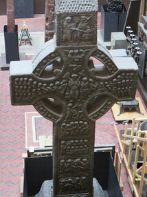
Digital Photograph, Dorothy Wickham, The Cast Courts, 2016, 09/2016
This ornate cross sits at the right hand side of View of Trajan's column, Cast Courts, Room 46a, The West Court, Victoria and Albert Museum, London. Cast Courts: "When the Architectural Courts – or Cast Courts as they are now known – opened in 1873, The Builder magazine compared the experience of seeing them to a first glimpse of Mont Blanc, creating one of those 'impressions that can scarcely be effaced'. Since then, these two enormous rooms and the reproductions they contain have continued to impress and inspire visitors to the Museum. For centuries, antiquarian interest in world architecture and sculpture led to reproductions – or copies – being made of outstanding national monuments and notable sculptures. When the Museum was founded, it collected and displayed reproductions of great art and architecture from across the world in order to offer objects for study and tell a complete story of the history of art and design. Casts are made by placing several plaster moulds upon the surface of the original structure. Once hardened and removed, the moulds are then enclosed in an outer casing, the interior coated with a separating agent and the wet plaster poured in. When set, the pieces are then assembled and the joints and surfaces finished off, to make a complete reproduction of the original work. The finished product – as well as being a formidable technical achievement in its own right – enables admirers to study faithful reproductions of important monuments and works of art." Ref: https://www.vam.ac.uk/articles/history-of-the-cast-courtslondon, victoria and albert museum, cast courts -
 Ballarat Heritage Services
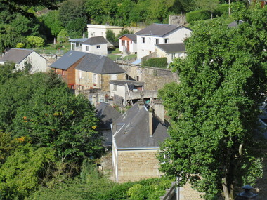
Digital Photograph, Dorothy Wickham, Vire, Normandie, France, 10/2016
The town of Vire is on a rocky promontory above the Vire River, situated in the south-west of the Calvados department of Lower Normandy, about half way between Caen (north-east of Vire) and Mont-Saint-Michel (to the south-west). Since 2016 the town has been part of the commune called Vire-Normandie. The town suffered quite heavily during bombardments at the end of the Second World War, and much reconstruction and renovation took place in the decade that followed the end of the war. (https://www.francethisway.com/places/vire.php) Julien Hardy, a stonemason and first discoverer of gold at Happy Valley, near Ballarat, Victoria Australia, was born near Vire, France. This photograph was taken by a descendant of Julian Hardy.Two colour photographs of buildings in the town of Vire, Normandie, France.julien hardy, vire, normandy -
 Bialik College
Photograph (Item) - Oliver , the musical, school Camp c1993, Oliver, the musical, school Camp c1993
C1993 Bialik students performed the musical, Oliver. Part of the creation and preparation period involved a multi-grade creative camp. A range of inscriptions that are on the back of many photographs show the diverse activities that took place as a Music teacher developed the character of Fargin, Shabbat at musical camp, aerobics and numerous cross age activities. For inquiries or access contact [email protected] range of inscriptions appear on the back of many photographs in blue pen, Teachers on Camp-Jean, Music teacher developing a character for "Oliver"- Fargin. Older and younger children together. Musical camp school common, musical rehearsal, Shabbat at musical camp, Oliver Camp, Year 4 taking aerobics at Oliver camp, First Aid at Oliver Camp, Simulation activity Oliver camp, Cross age activity, Year 4 teacher at Oliver camp. school, jewish school, bialik college, photographs., performing arts, musical -
 Geelong Football Club
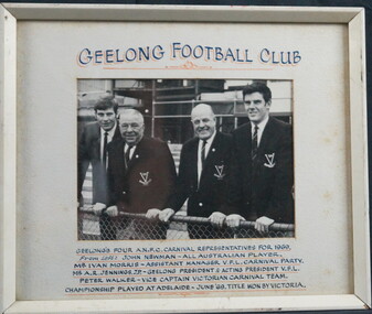
Photograph of Geelong Football Club's Four A.N.F.C. Carnival Representatives, 1969
Championship played at Adelaide in June 1969, Title won by Victoria. Peter Walker Born: 12/06/1942 From: Beeac Height: 183cm Weight: 76kg Natural kicking foot: Right Guernsey number: 34 First senior match: Round 3, 1960 v Fitzroy at the Brunswick Street Oval After taking time to settle at senior level, he found his rightful place on the half-back line. Once he gained confidence, he became a champion, dashing player who could mark above taller opponents and swing Geelong into attack instantly with fine disposal. His duels with Darrel Baldock of St Kilda were outstanding during the 1960s. He always played the game fairly and followed coaches’ instructions to the letter. Total Brownlow Medal votes: 32 Premiership team selection: 1963 Captain: 2 matches (1969) Club Best & Fairest: 1965 Runner-up in club B&F count: 1963 Third in club B&F count: 1967 Fifth in club B&F count: 1968, 1969 Eighth in club B&F count: 1964 (equal) GFC Hall of Fame inductee (2002) GFC Life Membership (1968) Career span: 1960-69; 1971 Total matches: Premiership 159, Interstate 9 Total goals: Premiership 1, Interstate 0 Finals matches: 15 Finals goals: 0 Last senior match: Round 11, 1971 v Richmond at Kardinia Park Died: 08/07/2010 John ‘Sam’ Newman Born: 22/12/1945 From: Geelong Grammar Height: 189cm Weight: 94kg Natural kicking foot: Right Guernsey number: 17 First senior match: Round 3, 1964 v Fitzroy at the Brunswick St Oval The champion ruckman/forward-pocket/back-pocket became a valuable centre half-forward late in his career. He was a magnificent high mark and a great handball exponent. His ability to maneuver his body into correct position at ruck contests and in marking duels was equal to that of Graham Farmer. He worked hard to overcome severe kidney and ankle injuries to play 300 matches for Geelong in a magnificent 17-season span. Total Brownlow Medal votes: 85 Captain: 41 matches (1974-75) Club Best & Fairest: 1968, 1975 Runner-up in club B&F count: 1974 Third in club B&F count: 1965, 1970, 1976 Fourth in club B&F count: 1969 Fifth in club B&F count: 1973, 1979 Seventh in club B&F count: 1967, 1977 All Australian selection: 1969 GFC Team of the 20th Century selection (back pocket) GFC Hall of Fame inductee (2002) GFC Hall of Fame Legend GFC Life Membership (1971) Career span: 1964-80 Total matches: Premiership 300, Night/Pre-Season Series 4, Interstate 8 Total goals: Premiership 110, Night/Pre-Season Series 4, Interstate 1 Finals matches: 12 Finals goals: 4 Last senior match: Second Semi Final, 1980 v Richmond at Waverley Park Information provided by Mr Col Hutchinson GFC HistorianWhite painted wooden frame with glass front. White mounting card surrounds the photograph. Black and white photograph of John 'Sam' Newman, Ivan Morris, A.R. Jack Jennings and Peter Walker standing in front of a wire fence. Above on the mounting card states "GEELONG FOOTBALL CLUB" and the supporting text below provides context for the photograph. Wire on the back for hanging.peter walker, john newman, sam newman, ivan morris, a.r. jack jennings -
 Ballarat Heritage Services
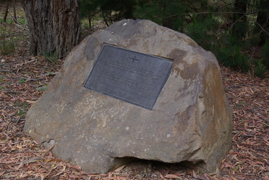
Photograph - Photograph - Colour Digital, Ballarat Reform League Inc Monument at Buninyong, 12/11/2012
Before the end of August 1851 the government had decided to charge a large licence fee for the right to search for gold. When news of that decision reached the Buninyong diggings, the first protest on the Victorian goldfields was held. The monument to that meeting has been placed at the site where it is believed that the meeting took place, in Hiscock Gully Road, about 400 metres from the Midland Highway.Colour photograph of a rock with a commemorative plaque outlining goldfields agitation at Buninyong.The plaque on the monument reads:- "Plaque on the Ballarat Reform League Inc. Monument at Buninyong, 2012. After the discovery of gold at Buninyong in August 1851 the government announced that the diggers would be charged a large licence fee. The injustice of that decision sparked a public protest here at the diggings. 'Buninyong 26 August - Tonight for the first time since Australia rose from the bossum of the ocean, were men strong in their sense of right, lifting up a protest against an impending wrong, and protesting against the Government. (Melbourne Argus, 20 August 1851)"ballarat reform league inc, goldfields agitation, buninyong monument, eureka stockade