Showing 3221 items
matching road map
-
 Whitehorse Historical Society Inc.
Document, Kelly Gang Film, 1994
Manuscript notes with typed copy. The 'Kelly Gang' film at 1320ft long which ran for over an hour is longer than the film 'The Great Train Robbery' (1903) claimed as the first full length picture made in the world.Manuscript notes with typed copy. The 'Kelly Gang' film at 1320ft long which ran for over an hour is longer than the film 'The Great Train Robbery' (1903) claimed as the first full length picture made in the world. 'Lowberry' timber house owned by McDonnells (with sketch map)Manuscript notes with typed copy. The 'Kelly Gang' film at 1320ft long which ran for over an hour is longer than the film 'The Great Train Robbery' (1903) claimed as the first full length picture made in the world. mcdonnell family, the story of the kelly gang (film), films -
Whitehorse Historical Society Inc.
Report, Charles William Gilbert Blake, 1/06/1997
Photocopy of school assignment. Includes information about a number of local war memorials and an investigation of Charles William Gilbert Blake whose name is on the Mitcham War Memorials. Blake enlisted in East Burwood. He trained in Egypt and was then sent to England where he died in hospital of an abscess in the brain. He is buried at the Tidworth Military Cemetery. Photographs. Maps. Approx 28 pagesblake, charles william gilbert, war memorials, world war, 1914 - 1918, tidworth military cemetery -
Whitehorse Historical Society Inc.
Document, My memories of the area around Simpson Park, 1/10/2003 12:00:00 AM
Memories with promptings from Jack Leach who lived in Rupert Street and later in Creek Road.Memories with promptings from Jack Leach who lived in Rupert Street and later in Creek Road. Describes that part of Mitcham south of the railway line between Creek Road and Cochrane street. A sketch map of the area as it was in the 1930's is also supplied.Memories with promptings from Jack Leach who lived in Rupert Street and later in Creek Road.brunswick road, mitcham, creek road, mitcham, cochrane street, mitcham, rupert street, mitcham, bloom family, leach, jack, leach family, simpson family, ferris, ray, simpson park -
Whitehorse Historical Society Inc.
Map, Schwerkolt property, 1/10/2003 12:00:00 AM
A reworking by Ted Arrowsmith of Arthur Schwerkolt's plan of the Schwerkolt property as it was in the 1930's.A reworking by Ted Arrowsmith of Arthur Schwerkolt's plan of the Schwerkolt property as it was in the 1930's.A reworking by Ted Arrowsmith of Arthur Schwerkolt's plan of the Schwerkolt property as it was in the 1930's.schwerkolt cottage, schwerkolt, arthur -
Whitehorse Historical Society Inc.
Pamphlet, Heritage Walk
Pamphlet describing a walk around Blackburn Lake and giving some of the history of the lake and its surrounding area. Includes map.Pamphlet describing a walk around Blackburn Lake and giving some of the history of the lake and its surrounding area. Includes map.Pamphlet describing a walk around Blackburn Lake and giving some of the history of the lake and its surrounding area. Includes map.blackburn lake, adult deaf and dumb society, lake park, flower growing, heidelberg school -
Whitehorse Historical Society Inc.
Pamphlet, Blackburn Lake Sanctuary, c2000
Description of the Blackburn Lake Sanctuary with a brief history, information about events held in the sanctuary and the role of the Blackburn Lake sanctuary Advisory Committee. Detailed map.Description of the Blackburn Lake Sanctuary with a brief history, information about events held in the sanctuary and the role of the Blackburn Lake sanctuary Advisory Committee. Detailed map.Description of the Blackburn Lake Sanctuary with a brief history, information about events held in the sanctuary and the role of the Blackburn Lake sanctuary Advisory Committee. Detailed map.blackburn lake, blackburn lake sanctuary advisory committee -
Whitehorse Historical Society Inc.
Pamphlet, Bellbird Dell
A pamphlet about a municipal reserve - Bellbird Dell, with a list of names of the Management Committee.A pamphlet about a municipal reserve - Bellbird Dell, with a list of names of the Management Committee. Also states they are looking for helpers for regular working bees. Includes map of reserve.A pamphlet about a municipal reserve - Bellbird Dell, with a list of names of the Management Committee.local government, city of nunawading, bellbird dell, vermont -
Whitehorse Historical Society Inc.
Map, Boronia Road, Vermont, 1970
... Road, Vermont Map Map ...Enlargement of aerial photograph of Boronia Road, Vermont. State Aerial Survey 1970 Run 37Enlargement of aerial photograph of Boronia Road, Vermont. State Aerial Survey 1970 Run 37Enlargement of aerial photograph of Boronia Road, Vermont. State Aerial Survey 1970 Run 37boronia road, vermont, lusk drive, vermont, morack road, vermont south, allison court, vermont, trinian street, vermont, cosgrove street, vermont, mawson court, vermont, aerial photographs -
Whitehorse Historical Society Inc.
Map, Boronia Road, Vermont, 1970
... Survey, 1970. Run 37 Boronia Road, Vermont Map Map ...Enlargement of Aerial photograph of Boronia Road Vermont, State Aerial Survey, 1970. Run 37Enlargement of Aerial photograph of Boronia Road Vermont, State Aerial Survey, 1970. Run 37Enlargement of Aerial photograph of Boronia Road Vermont, State Aerial Survey, 1970. Run 37boronia road, vermont, gallus close, vermont, moore road, vermont, carlinga drive, vermont, beleura avenue, vermont, olinda crescent, vermont, penllyne avenue, vermont, holyrood drive, vermont, aerial photographs -
Whitehorse Historical Society Inc.
Map, Deep Creek Road, Mitcham, c1975
... Highway, Mitcham Deep Creek Road, Mitcham Map Map ...Enlargement of aerial photograph of area bounded by Dalmar Road, Cray Road, Glenvale Road and Maroondah Highway, MitchamEnlargement of aerial photograph of area bounded by Dalmar Road, Cray Road, Glenvale Road and Maroondah Highway, MitchamEnlargement of aerial photograph of area bounded by Dalmar Road, Cray Road, Glenvale Road and Maroondah Highway, Mitchamcray road, donvale, glenvale road, donvale, maroondah highway, mitcham, dalmor road, mitcham, deep creek road, mitcham, aerial photographs -
Whitehorse Historical Society Inc.
Map, Whitehorse Road, Mitcham, 1972
... . Whitehorse Road, Mitcham Map Map ...Enlarged aerial photograph of area around intersection of Whitehorse Road and Heatherdale Roads, Mitcham.Enlarged aerial photograph of area around intersection of Whitehorse Road and Heatherdale Roads, Mitcham.Enlarged aerial photograph of area around intersection of Whitehorse Road and Heatherdale Roads, Mitcham.whitehorse road, mitcham, heatherdale road, mitcham, ringwood, maroondah highway, aerial photographs -
Whitehorse Historical Society Inc.
Map, Whitehorse Road, Blackburn, 1970
... Whitehorse Road, Blackburn Map Map ...Enlarged aerial photograph of area around intersection of Whitehorse and Middleborough Roads, BlackburnEnlarged aerial photograph of area around intersection of Whitehorse and Middleborough Roads, BlackburnEnlarged aerial photograph of area around intersection of Whitehorse and Middleborough Roads, Blackburnwhitehorse road, blackburn, middleborough road, blackburn, maroondah highway, box hill, aerial photographs -
Whitehorse Historical Society Inc.
Map, Walker Park, Nunawading, c1970?
Enlarged aerial photograph of area of Walker Park, Nunawading, 1970 runEnlarged aerial photograph of area of Walker Park, Nunawading, 1970 run.Enlarged aerial photograph of area of Walker Park, Nunawading, 1970 runwalker park, whitehorse road, nunawading, maroondah highway, dunlavin road, nunawading, mitcham technical school, aerial photographs -
Whitehorse Historical Society Inc.
Map, Canterbury Road, Blackburn, 1972
... and Middleborough Roads, Blackburn. Canterbury Road, Blackburn Map Map ...Enlarged aerial photograph of area around the intersection of Canterbury and Middleborough Roads, Blackburn.Enlarged aerial photograph of area around the intersection of Canterbury and Middleborough Roads, Blackburn.Enlarged aerial photograph of area around the intersection of Canterbury and Middleborough Roads, Blackburn.canterbury road, blackburn, middleborough road, blackburn, box hill, craig street, blackburn, hirst street, blackburn, aerial photographs -
Whitehorse Historical Society Inc.
Map, Blackburn Road, Blackburn, 1970
... Road, Blackburn Map Map ...Enlarged aerial photograph of area around the intersection of Blackburn and Canterbury Roads, Blackburn.Enlarged aerial photograph of area around the intersection of Blackburn and Canterbury Roads, Blackburn.Enlarged aerial photograph of area around the intersection of Blackburn and Canterbury Roads, Blackburn.canterbury road, blackburn, blackburn road, blackburn, rosslyn street, blackburn south, masons road, blackburn, lavelle street, blackburn, vernon street, blackburn, wirreanda court, blackburn, aerial photographs -
Whitehorse Historical Society Inc.
Map, Campbell's Croft, c1970
Enlarged aerial photograph of the area around Campbell's Croft Reserve. State aerial Survey, Melbourne, 1970 project. Run 37Enlarged aerial photograph of the area around Campbell's Croft Reserve. State aerial Survey, Melbourne, 1970 project. Run 37Enlarged aerial photograph of the area around Campbell's Croft Reserve. State aerial Survey, Melbourne, 1970 project. Run 37campbells croft, boronia road, vermont, madonna court, vermont, aerial photographs -
Whitehorse Historical Society Inc.
Map, Boronia Road, Canterbury Road intersection, c1970
... Whitehorse Historical Society Inc. 2-10 Deep Creek Road ...Enlarged aerial photograph of the intersection of Canterbury and Boronia Roads. State Aerial Survey, Melbourne 1970 project.Enlarged aerial photograph of the intersection of Canterbury and Boronia Roads. State Aerial Survey, Melbourne 1970 project.Enlarged aerial photograph of the intersection of Canterbury and Boronia Roads. State Aerial Survey, Melbourne 1970 project.boronia road, vermont, canterbury road, vermont, mitcham road, vermont, frances avenue, vermont, nurlendi road, vermont, beaumont street, vermont, kingsclere street, vermont, webb court, vermont, aerial photographs -
Whitehorse Historical Society Inc.
Map, Canterbury Road, Vermont, c1970
... Road, Vermont Map Map ...Enlarged aerial photo of intersection of Canterbury and Boronia Roads. State Aerial Survey, Melbourne 1970 project.Enlarged aerial photo of intersection of Canterbury and Boronia Roads. State Aerial Survey, Melbourne 1970 project.Enlarged aerial photo of intersection of Canterbury and Boronia Roads. State Aerial Survey, Melbourne 1970 project.canterbury road, vermont, boronia road, vermont, mitcham road, vermont, frances avenue, vermont, nurlendi road, vermont, webb court, vermont, vermont primary school, no. 1022, aerial photographs -
Whitehorse Historical Society Inc.
Map, Blackburn Lake, c1968
Enlarged aerial photograph of Blackburn Lake area.Enlarged aerial photograph of Blackburn Lake area.Enlarged aerial photograph of Blackburn Lake area.blackburn lake sanctuary, adult deaf & dumb home, lake road, blackburn, central road, blackburn, aerial photographs -
Whitehorse Historical Society Inc.
Map, Highbury Road, c1970
... aerial photo of Highbury Park area. Highbury Road Map Map ...Enlarged aerial photo of Highbury Park area.Enlarged aerial photo of Highbury Park area.Enlarged aerial photo of Highbury Park area.highbury road, burwood east, gareth drive, burwood east, blackburn road, burwood east, bennett avenue, burwood east, rae street, burwood east, joy street, burwood east, folkestone road, burwood east, burwood east primary school no. 454, aerial photographs -
Whitehorse Historical Society Inc.
Map, Mitcham Road, c1970
... and Mitcham Roads, Mitcham. Scale 1 inch : 40 feet Mitcham Road Map ...Enlarged aerial photograph of intersection of Whitehorse and Mitcham Roads, Mitcham. Scale 1 inch : 40 feetEnlarged aerial photograph of intersection of Whitehorse and Mitcham Roads, Mitcham. Scale 1 inch : 40 feetEnlarged aerial photograph of intersection of Whitehorse and Mitcham Roads, Mitcham. Scale 1 inch : 40 feetmitcham road, mitcham, maroondah highway, mitcham, whitehorse road, mitcham, mitcham primary school, no. 2904, mitcham hotel, aerial photographs -
Whitehorse Historical Society Inc.
Map, Blackburn, 13/01/1977 12:00:00 AM
Enlarged aerial photograph of Blackburn Business Centre. Scale 1:150 metric.Enlarged aerial photograph of Blackburn Business Centre. Scale 1:150 metric.Enlarged aerial photograph of Blackburn Business Centre. Scale 1:150 metric.blackburn, blackburn road, blackburn, south parade, blackburn, railway road, blackburn, maroondah highway, blackburn, whitehorse road, blackburn, chapel street, blackburn, albert street, blackburn, queen street, blackburn, station street, blackburn, blackburn railway station, blackburn primary school, no. 2923, aerial photographs -
Whitehorse Historical Society Inc.
Map, Springvale Road, c1970
... and Whitehorse Roads, Nunawading. Springvale Road Map Map ...Enlarged aerial photo of intersection of Springvale and Whitehorse Roads, Nunawading.Enlarged aerial photo of intersection of Springvale and Whitehorse Roads, Nunawading.Enlarged aerial photo of intersection of Springvale and Whitehorse Roads, Nunawading.springvale road, nunawading, whitehorse road, nunawading, maroondah highway, nunawading, aerial photographs -
Whitehorse Historical Society Inc.
Map, Burwood Highway, c1970
Enlarged aerial photo of area South of Burwood Highway to Dandenong Creek, Vermont South.Enlarged aerial photo of area South of Burwood Highway to Dandenong Creek, Vermont South.Enlarged aerial photo of area South of Burwood Highway to Dandenong Creek, Vermont South.dandenong creek, morack road, vermont south, burwood highway, vermont south, aerial photographs -
Whitehorse Historical Society Inc.
Map, Mitcham Road, c1970
... . Mitcham Road Map Map ...Enlarged aerial photo of the intersection of Mitcham and East Doncaster Roads, Mitcham. Scale 1 inch : 40 feet.Enlarged aerial photo, c1970, of the intersection of Mitcham and East Doncaster Roads, Mitcham. Scale 1 inch : 40 feet.Enlarged aerial photo of the intersection of Mitcham and East Doncaster Roads, Mitcham. Scale 1 inch : 40 feet.mitcham road, mitcham, quarry road, mitcham, doncaster east road, mitcham, wooddale grove, mitcham, mitcham primary school, no. 2904, aerial photographs -
Whitehorse Historical Society Inc.
Letter - Correspondence, Valuation of Abattoirs Paddock lots, 1932
Letter from Shire valuer to Cit of Box Hill re valuations of Abattoir Paddock lots, including map of lots.Letter from Shire valuer to Cit of Box Hill re valuations of Abattoir Paddock lots, including map of lots.Letter from Shire valuer to Cit of Box Hill re valuations of Abattoir Paddock lots, including map of lots.shire of blackburn and mitcham, city of box hill, abattoirs paddock, aspinall's estate, woodhouse grove, box hill north -
Whitehorse Historical Society Inc.
Document, Street names, 1989
Artic;le by Gwenda Trethewy, member of Nunawading Historical SocietyArtic;le by Gwenda Trethewy, member of Nunawading Historical Society, on the history of the Mitcham street names, Endeavour, Flinders, Moresby and Beaufort, Oct - Dec 1989 and map of the area and an extract of the article.Artic;le by Gwenda Trethewy, member of Nunawading Historical Societystreet names, trethewey, gwenda, turner, (commander), nunawading historical society, endeavour street, mitcham, flinders street, mitcham, moresby street, mitcham, beaufort street, mitcham -
Whitehorse Historical Society Inc.
Map, Plan, 1939
Plan of subdivision, part of crown portion 83A and 83, Parish of Nunawading, County of BourkePlan of subdivision, part of crown portion 83A and 83, Parish of Nunawading, County of BourkePlan of subdivision, part of crown portion 83A and 83, Parish of Nunawading, County of Bourkestreet names, parish of nunawading, station street, blackburn, railway road, blackburn, vine street, blackburn, south parade, blackburn, laburnum street, blackburn, main street, blackburn, gardenia street, blackburn, the avenue, blackburn, fuschia street, blackburn, linum street, blackburn -
Whitehorse Historical Society Inc.
Map, Parish of Nunawading, 1939
... Stanley Road Parish of Nunawading Map Map ...Plan of subdivision part of crown portions 81, 82 and 89,Plan of subdivision part of crown portions 81, 82 and 89, Parish of Nunawading, County of Bourke, Blackburn Wellington Avenue amended from Stanley RoadPlan of subdivision part of crown portions 81, 82 and 89, street names, parish of nunawading, blackburn road, blackburn, wellington avenue, blackburn, wolseley crescent, blackburn, gordon crescent, blackburn, clarke street, blackburn, central road, blackburn -
 Whitehorse Historical Society Inc.
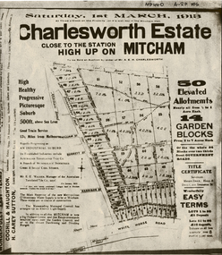
Document, Charlesworth Estate, 1913
Charlesworth Estate, Mitcham. 50 elevated allotments, 1/2 to 1 acre each and 14 garden blocks from 2 to 7 acres each. 1 March 1913.Brochure for auction of Charlesworth Estate, Mitcham. 50 elevated allotments, 1/2 to 1 acre each and 14 garden blocks from 2 to 7 acres each. 1 March 1913. Agents: Coghill & Houghton and H. Carey Sutton.Charlesworth Estate, Mitcham. 50 elevated allotments, 1/2 to 1 acre each and 14 garden blocks from 2 to 7 acres each. 1 March 1913.auctions, charlesworth estate, mitcham, quarry road, doncaster east road, burnett street, harrison street, whitehorse road