Showing 110298 items matching "roads"
-
 Whitehorse Historical Society Inc.
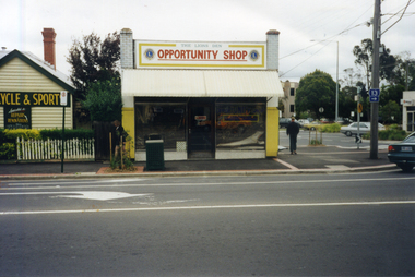
Photograph, Lion's Opportunity Shop, Blackburn, Taken 1998
Coloured photograph of the Lion's Blackburn Opportunity Shop, Mitcham Road, Blackburn, just north of the railway line. The other road in the photograph is Railway Roadlion's opportunity shop, blackburn, opportunity shops -
 Canterbury History Group
Photograph - The Block, Maling Road, Canterbury c1910, c1910
The Block, Maling Road from the end of Rochester Road c 1910. Built by Frederick Green in 1907, first substantial development in Maling Road.canterbury, maling road, the block, green> frederick -
Canterbury History Group
Photograph - Canterbury Mansions, Jan Pigot, 27/03/1993 12:00:00 AM
Coloured photograph of the view of the Canterbury Mansions from the front door facing Canterbury Road. Also visible are Wattle Valley Road and Maling Road.canterbury, maling road, shops, victorian architecture, canterbury post office -
 Melbourne Tram Museum
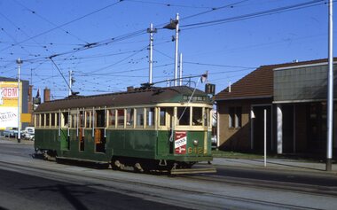
Slide, Keith Kings, 17/04/1968 12:00:00 AM
35mm Kodak white cardboard colour slide by Keith Kings of W2 642 leaving or shunting at East Preston Depot, Plenty Road. has the destination of East Preston Bell St, route 11 and a advert for Reddi. Photo 17/4/1968. See Inscription for a note re the roof.Keith Kings stamp and number "22-3", with details of exposure. "MMTB W2 642, Plenty Road East Preston Depot - vent roof and drip rails. 17/4/1968trams, tramways, w2 class, east preston depot, plenty road, route 11, tram 642 -
 Whitehorse Historical Society Inc.
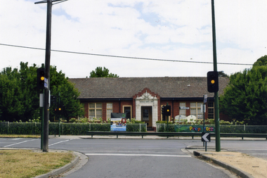
Photograph, Mitcham Primary School No 2904
On 24th September 1888 a wooden state school opened on land purchased on the north west corner of Whitehorse and Mitcham Roads. In 1890 a contract was let for the construction of a one-room brick school house on that site. By 1907 student numbers had risen to 120 so the Church of Christ Hall was leased for 10/- a week. By 1922 cracks had appeared, plaster had fallen in the school and both the Brittania Street Scout Hall and the Methodist Church has been leased for classrooms. On 10/4/1930, a new school, to be occupied by the upper grades was opened in its present location.Coloured picture of Mitcham Primary School No 2904 The traffic lights are at the intersection of Mitcham and Doncaster East Roads - 2012mitcham primary school no. 2904, schools -
 Melbourne Tram Museum
Photograph - Black and white - Glenferrie Road, Glenferrie c1915
Shows Glenferrie Road, near Linda St looking south, c1915 prior to the construction of the Railway overpass at Glenferrie Railway Station with H class tram 58 in the view. The tram line was constructed in 1913. It would appear that the level crossing gates are closed in the photograph. The building on the right-hand side by the horse-drawn cart was an ANZ bank until 2021. The closer building, a theatre (The Palace) has since been demolished and is now a Coles Supermarket. The level crossing was replaced with an overbridge in April 1916. The church in the background is the Immaculate Conception Church, without the spires - built after WW1. Yields information about the location, the streetscape and the tram, vehicles in use at the time. Black and white photograph of Glenferrie Road Glenferrie with tram H58, looking south near Linda St, c1915."RSCP 327" & "C1920s" in pencil on rear and H58 in red ink.tramways, trams, glenferrie road, hawthorn, streetscapes, h class, tram 58 -
 Ringwood and District Historical Society
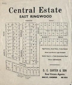
Flyer, Land Sale Advertisement, Central Estate, East Ringwood - 1948
East Ringwood Central Estate auction sale of allotments previously advertised for Saturday October 23rd (1948). Victorian Collections reference 5138 refers.Single sided leafletSubdivision includes Dublin Road, Knaith Road, Talofa Avenue, Russet Road, and Shasta Avenue. Agent - C.E. Carter & Son, Main Street, Ringwood. WU 6024. -
Glenelg Shire Council Cultural Collection
Photograph - Photograph - rural scene, Glenelg Shire, n.d
Coloured photograph of a road, car in foreground, trees and houses on sides of road - unidentifiedphotography, rural scene, landscape -
 Eltham District Historical Society Inc
Photograph, Main Road, Panton Hill
Colour photograph of Main Road Panton Hill showing roundabout at Bishops Road.main road, st andrews road, kangaroo ground/st andrews road, bishops road, roundabouts, panton hill -
 Bendigo Historical Society Inc.
Photograph - 'MARYDALE' AXEDALE COLLECTION: PANORAMIC PHOTO
Panoramic photo of open land with road and bridge, taken from Ingham's Road.axedale, history, marydale property -
Whitehorse Historical Society Inc.
Newspaper, Along the highway, 1992
A guide to business along the Maroondah Highway from Middleborough Road to Heatherdale Road.A guide to business along the Maroondah Highway from Middleborough Road to Heatherdale Road.A guide to business along the Maroondah Highway from Middleborough Road to Heatherdale Road.maroondah highway blackburn, pharmacies, maroondah highway mitcham, athan, savvas, maroondah highway nunawading, gelb, joe, mitcham shopping centre, regal kitchens, blackburn, nunawading fire station, armstrong, norman -
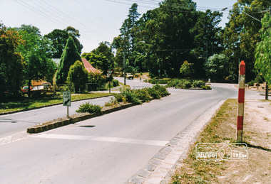
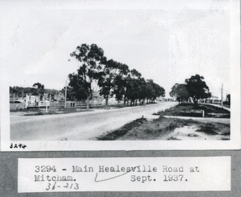 Whitehorse Historical Society Inc.
Photograph, Whitehorse Road, Healesville 1937, 1/09/1937 12:00:00 AM
Black and white photograph of main Healesville Road (Whitehorse road) in September 1937.healesville road, mitcham, whitehorse road -
 Whitehorse Historical Society Inc.
Photograph, Blackburn Road Park, 1/01/2001 12:00:00 AM
Black and white photograph of park on corner of Blackburn Road and Canterbury Road, Blackburn.canterbury road, blackburn, blackburn road -
 Whitehorse Historical Society Inc.
Photograph, Canterbury Road, Vermont, C.1967, C.1967
Part of Tim Shambrook's Collection for 'This is Vermont'. Not used.Coloured photo of Canterbury Road, Vermont in 1967, showing single lane road.canterbury road, vermont., shambrook, tim -
 Whitehorse Historical Society Inc.
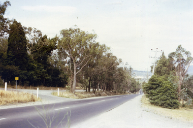
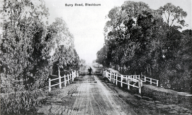
Photograph - Black and white photograph, Surrey Road Blackburn
Used by donor in 'Blackburn - a picturesque history'Black & white photo of Surry (sic) Road Blackburn (captioned) Surrey Roadsurrey road, blackburn, surry road bridge -
 Whitehorse Historical Society Inc.
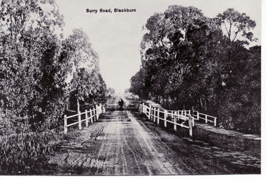
Photograph, Surrey Road, Blackburn
Black and white photo of Surrey road, Blackburn (captioned Surry Road (sic))blackburn, surrey road, surry road -
 Bendigo Historical Society Inc.
Photograph - CASTLEMAINE GAS COMPANY COLLECTION: PHOTO PLACING PIT, 12/04/1991
Placing Pit Into Position - Eaglehawk Road/Havilagh Road - 12/04/1991Polaroidorganisation, industry, gas and fuel -
Canterbury History Group
Ephemera - Maling Road Canterbury, 2000
A list of traders on the north and south sides Maling Road from Canterbury Road.canterbury, maling road, shopkeepers, shops -
Canterbury History Group
Photograph - Detail of tiled floor in No. 88 Maling Road, Jan Pigot, 27/03/1993 12:00:00 AM
Coloured photograph of the tiled floor in the Maling Road Patisserie at No. 88 Maling Roadcanterbury, maling road, shops, floors -
Canterbury History Group
Photograph - View of the Maling Road Theatre, Maling Road, Jan Pigot, 27/03/1993 12:00:00 AM
Coloured photograph of the Maling Road Theatre from No. 111 to No. 119 Maling Roadcanterbury, maling road, shops, edwardian architectural detail -
 Kew Historical Society Inc
Photograph - 'Reno', 10 St John's Parade, John T Collins, 1977
‘Reno’, stood on the east side of St John’s Parade. Its earliest recorded owner was the architect Samuel Cocking who lived there from c.1865 until his death in 1888. The original landholding was bordered by Cotham Road, Glenferrie Road, Wellington Street, and Charles Street. The southern portion of this land included a fine orchard, with many imported trees. The old summer house, at first in the orchard, was later removed to the house garden. The MMBW Detail Plan No.1576 (1904) shows the remaining portion of the original land holding, including a semi-circular pathway at the front, and garden features such as an aviary, a fountain and grotto, and a fernery. The garden including rare plants supplied by Baron Von Mueller, surrounds the cottage in a tangled frenzy. Despite a ‘local significance’ classification by the National Trust, the house was demolished in 1977.Partial view, north side of the weatherboard cottage in St John's Parade, Kew, known as 'Reno' (demolished 1977). Architectural elements revealed in this photo by John T Collins include: two wing, hip roof construction; external buildings at angles to main wing; corrugated iron roofing [over shingles]; brick chimney external to building; unvarnished/unpainted external weatherboards. General dilapidated condition. "Kew 'Reno' 10 St Johns Pde / John Collins, 11 Anderson Road, Hawthorn East, 3123, Film 35B Exposure 27"reno - st john's parade -- kew (vic.), john t collins -
 Kew Historical Society Inc
Photograph - 'Reno', 10 St John's Parade, John T Collins, 1977
‘Reno’, stood on the east side of St John’s Parade. Its earliest recorded owner was the architect Samuel Cocking who lived there from c.1865 until his death in 1888. The original landholding was bordered by Cotham Road, Glenferrie Road, Wellington Street, and Charles Street. The southern portion of this land included a fine orchard, with many imported trees. The old summer house, at first in the orchard, was later removed to the house garden. The MMBW Detail Plan No.1576 (1904) shows the remaining portion of the original land holding, including a semi-circular pathway at the front, and garden features such as an aviary, a fountain and grotto, and a fernery. The garden including rare plants supplied by Baron Von Mueller, surrounds the cottage in a tangled frenzy. Despite a ‘local significance’ classification by the National Trust, the house was demolished in 1977.Partial view, side of the weatherboard cottage in St John's Parade, Kew, known as 'Reno' (demolished 1977). Architectural elements revealed in this photo by John T Collins include: hip roof construction; corrugated iron roofing [over shingles]; unvarnished/unpainted external weatherboards; Externally opening 1860s-style casement window. General dilapidated condition. "Kew 'Reno' 10 St Johns Pde / John Collins, 11 Anderson Road, Hawthorn East, 3123, Film 35B Exposure 26"reno - st john's parade -- kew (vic.), john t collins -
 Kew Historical Society Inc
Photograph - 'Reno', 10 St John's Parade, John T Collins, 1977
‘Reno’, stood on the east side of St John’s Parade. Its earliest recorded owner was the architect Samuel Cocking who lived there from c.1865 until his death in 1888. The original landholding was bordered by Cotham Road, Glenferrie Road, Wellington Street, and Charles Street. The southern portion of this land included a fine orchard, with many imported trees. The old summer house, at first in the orchard, was later removed to the house garden. The MMBW Detail Plan No.1576 (1904) shows the remaining portion of the original land holding, including a semi-circular pathway at the front, and garden features such as an aviary, a fountain and grotto, and a fernery. The garden including rare plants supplied by Baron Von Mueller, surrounds the cottage in a tangled frenzy. Despite a ‘local significance’ classification by the National Trust, the house was demolished in 1977.Side of the original, relocated summer house of 'Reno' at 10 St John's Parade, Kew, (demolished 1977). Architectural elements revealed in this photo by John T Collins include: four-sided construction; trellis and weatherboard walls; corrugated iron roofing. Re-use as woodshed. General dilapidated condition. "Kew 'Reno' 10 St Johns Pde / John Collins, 11 Anderson Road, Hawthorn East, 3123, Film 35B Exposure 24"reno - st john's parade -- kew (vic.), john t collins -
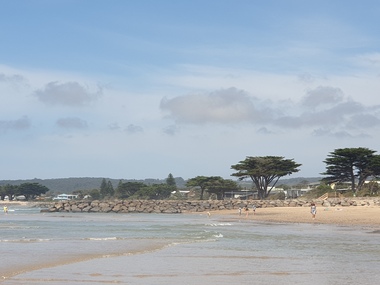 Ballarat Heritage Services
Photograph, Clare Gervasoni, Apollo Bay, Victoria, 24/01/2022
In 2021, the Department of Environment, Land, Water and Planning (DELWP) constructed two new groynes and a section of rock seawall at Apollo Bay to help manage the impacts of coastal erosion. The new 70-meter-long rock groynes run perpendicular to the shoreline and be located just south of the Milford St revetment and to the south of Milford Creek. Sections of rock seawall will be constructed between the two Groynes with an aim to protect the dune, walking path, cypress trees and road from erosion. Colour photograph of a coastal scene at Apollo Bay, featuring new rock groynes to protect the Great Ocean Road from erosion. apollo bay, beach, coast, groyne, rockwall -
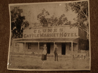 Clunes Museum
Photograph
CLUNES CATTLEMARKET HOTEL. BUILT ON THE SOUTH SIDE OF SMEATON ROAD BETWEEN DARLING AND BARKLEY STREETS..1.2 BLACK AND WHITE PHOTOGRAPH OF CLUNES CATTLEMARKET HOTEL, LOCATED ON SMEATON ROAD, CLUNES, MAN AND LADY STANDING IN FRONT .DOG RESTING ON VERANDAH. WOODEN CONSTRUCTION WITH SHINGLE ROOF. ENLARGED PHOTOGRAPHS .3-..6 BLACK AND WHITE PHOTOGRAPHS OF CLUNES CATTLE MARKET HOTEL..1 HANDWRITTEN ON BACKAUNTIE SIS AND UNCLE OWEN. MISS SYMONS AND BROTHER RELATED TO SPARKS . MAYOR - BUTCHER. CATTLE MARKET HOTELlocal history, photography, photographs, hotels - cattle market -
 Whitehorse Historical Society Inc.
Photograph, Springvale Road East Burwood
The Tally Ho Business Park was built on vacant land previously owned by the Methodist Church. The land was sold cheaply to the Church by Abel Hoadley, and the Tally Ho Boys Home was erected there. A change in the care of the boys meant that the land became vacant for a considerable time before buildings appeared. The Country Fire Authority, Vic Roads and World Vision are also located there.4 coloured photographs (a-d) taken at the intersection of Springvale Road & Burwood Hwy East Burwood. First stages of the Tally Ho Business Park in the background.tally ho business park, businesses -
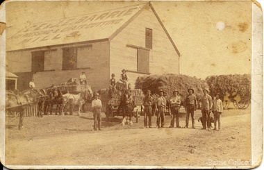 Melton City Libraries
Photograph, 'Melton South Chaff Mill employees, Unknown
Charles E “Ernie” Barrie started constructing a Chaff mill on the corner of Brooklyn and Station road in 1900. It soon became a thriving business and was ideally located close to the railway line. Ernie and his father William and other Barrie brothers had been operated travelling chaff cutters in the district of Melton and Werribee. Within a short time the mill expanded into two big sheds in partnership with his brother James E known as “Ted”. The eldest brother William was in the Manager living in Melton South. In 1906 Ernie applied for a railway crossing on Brooklyn Road to have direct access for railway trucks to be shunted to the mill to be loaded. The Mill was also had the first phone to be connected, No 1, and No’s 2, 3 were the Golden Fleece and Macs Hotels. In 1906 Ernie married Jessie Lang daughter of the Head Teacher at Melton State School No 430 (1896 –1917). The Barrie house on the north side of the mill was completed in August 1906. It survived for almost 60 years until demolition. Chaff mills were very susceptible to fires and often burnt down and would be rebuilt again ready for the peak of the harvesting season. The final demise of the Mill occurred in a spectacular blaze on the night of Friday 2nd December 1977, just before the earth tremor as reported in the local paper. Brian Dobson the local photographer lived close by and captured the night blaze. A video was also taken of the action by the fire brigade. My parents Bon and Edna Barrie were living at 19 First Avenue, and took colour slides of the smouldering ruins in the half -light. Ironically Bon had spent the first year of his life (born in April 1909 and sister Mary born October 1907) at the house beside the mill. Trethowan’s Chaff mill in Brooklyn road was also destroyed by fire, which stated in the evening on Tuesday April 28th 1987. It was established in 1910 by Dixon Brothers, followed by, Ebbot & Kebby, Robinson, Trethowan and Butler and was with the Trethowan family when it burnt down. Melton South was small a community referred to as Melton Railway Station. Member of the community raised the idea to have a public hall. In 1909 Cr Barrie, Mr Nesbitt and Delany formed a committee to build a community hall. Cr Barrie donated the land and The Exford Hall was completed in September 1910 later to be named Victoria Hall. It was demolished in 1992. Colour slide in Barrie archive. In April 1910 the Ernie sold the Mill to Glover Onians (HSK Ward) family moved away to a property in Trundle NSW. Ernie had acquired 640 acres (a square mile) and leased a further 1920 acres of adjoining land. It was the practise of the farmers in the area at the time to buy up or lease the surrounding land from the 640 acre crown land blocks to make up acerage for a viable wheat farm. His wife Jessie found the climate to be very hot and when the Darlingsford property at Melton was put up for sale in the latter part of 1910 and was passed in at the auction. My grandfather saw this an opportunity to return to Melton. The negotiations to Darlingsford were finalised on May 11th 1911. Barrie bothers with connections to Chaff mills and farming in Melton from the 1900s William Henry, Charles Ernest, James Edwin, Samuel John, Robert, Arthur Roger, Albert Walter. Three grandsons and a great-grandson are in business earthmoving and farming in Melton today. (2013) Memoirs by Wendy BarrieEmployees at Chaff Mill, it was located on the corner of Brooklyn and Station Road, Melton South. local identities, agriculture -
 Whitehorse Historical Society Inc.
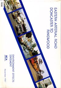
Book - Government Environment Effects Statement, Road Construction Authority (now part of VicRoads), Eastern Arterial Road - Doncaster to Ringwood, November 1987
The book covers the Environment Effects Statement for the Eastern Arterial Road Extension from Doncaster to Ringwood and the Ringwood Bypass. Aspects covered are development works, traffic affects, public transport, landscape and visual affects, noise, pedestrian/ bicycle access, lighting, air quality and construction affects. Includes maps, cross sections, photos.The book covers the Environment Effects Statement for the Eastern Arterial Road Extension from Doncaster to Ringwood and the Ringwood Bypass. Aspects covered are development works, traffic affects, public transport, landscape and visual affects, noise, pedestrian/ bicycle access, lighting, air quality and construction affects. Includes maps, cross sections, photos.non-fictionThe book covers the Environment Effects Statement for the Eastern Arterial Road Extension from Doncaster to Ringwood and the Ringwood Bypass. Aspects covered are development works, traffic affects, public transport, landscape and visual affects, noise, pedestrian/ bicycle access, lighting, air quality and construction affects. Includes maps, cross sections, photos.eastern freeway extension, eastern arterial road, mullum mullum creek, road construction, environmental impact -
 Eltham District Historical Society Inc
Slide, Beard Street, Eltham, c. Jan 1983
... roads ...Roll of film taken by Eltham Shire Council officers of the Beard street group, a private street scheme, before construction commenced. They provide perspective of the changes in housing styles and road development that began sweeping in from the mid 1970s with increasing urbanisation of what was once more outlying suburbs and regions.35 mm colour positive transparency (1 of 7) Mount - Blank Card,eltham, housing estate, infrastructure, private street scheme, roads, frank street, beard street -
Whitehorse Historical Society Inc.
Document, Eastern Freeway Extension, 2000 - 2001
Agendas, minutes and papers of the Eastern Freeway Extension Community Liaison GroupAgendas, minutes and papers of the Eastern Freeway Extension Community Liaison Group (Nos 18 - 25) and Community Advisory Group (No 1 - ) Springvale Road to Ringwood with Community Workshops. Consolidated notes on the Extension and Funnel Ventilation Stacks.Agendas, minutes and papers of the Eastern Freeway Extension Community Liaison Groupeastern freeway, vicroads, city of whitehorse, city of manningham, city of maroondah