Showing 1988 items matching "victoria bridge"
-
 Lakes Entrance Historical Society
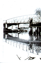
Photograph - Bridges, 1935
... Also second photograph of swing bridge closed with lady ...Also second photograph of swing bridge closed with lady in the foreground 6 x 8.5Black and white photograph showing closed swing bridge over Latrobe River, corner of jetty lower right hand corner. Sale, Victoria.bridges, waterways, jetties -
 Lakes Entrance Historical Society
Photograph - Bridges, Jemmeson, Edie, 1925
... the Latrobe River at Longford, Victoria. Photograph Bridges Jemmeson ...Also photograph of the bridge closed 7 x 11.5Black and white photograph of the swing bridge open over the Latrobe River at Longford, Victoria.bridges, waterways -
 Lakes Entrance Historical Society
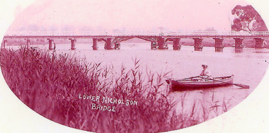
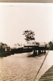
Photograph - Bridges, 1900
... in foreground. Nicholson Victoria Photograph Bridges ...Opened March 1889, centre lifting span unsuccessful so shipping trade up Nicholson River effectivly terminatedPink toned scanned photograph of the first bridge across the Nicholson River. Shows a timber bridge with centre designed as a drawbridge. Woman in rowing boat in foreground. Nicholson VictoriaNicholson River Bridgebridges, waterways -
 Lakes Entrance Historical Society
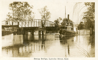
Postcard - Bridges, 1925
... at Longford near Sale, Victoria. Postcard Bridges ...Note on back dated Christmas 1926Sepia postcard showing steamer Omeo passing through opened swing bridge on Latrobe River at Longford near Sale, Victoria.Swing Bridge, Latrobe River, Saleboats and boating, bridges -
 Lakes Entrance Historical Society
Photograph - Bridges, 1950
... in background. Bairnsdale Victoria Photograph Bridges ...Colour photograph of unfinished Cataraman Llinase on Mitchell River, at Bairnsdale Wharf, railway bridge and highway bridge over the river, road to Paynesville under bridge, wharf on left, Mt Taylor and Mt Lookout in background. Bairnsdale Victoriabridges, waterways, boats and boating -
 Lakes Entrance Historical Society
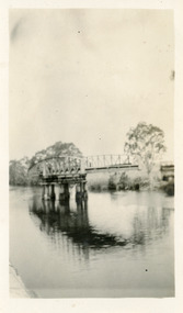
Photograph, 1925
Sepia photograph showing swing bridge open, on Latrobe River, at Longford, Victoriabridges, waterways -
 Lakes Entrance Historical Society
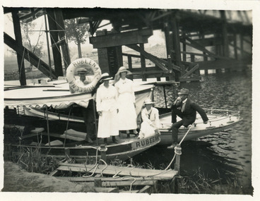
Photograph - Rubeena, 1923 c
Black and white photograph showing two tourist ferries, MV Rubeena and possibly MV Loch Ard, tied up below the old Swan Reach bridge on the Tambo River. Shows three ladies on the Rubeena, and one man on the Loch Ard. The Union Jack flag flying on the Loch Ard. Swan Reach Victoriawaterways, boats and boating, tourism -
 Lakes Entrance Historical Society
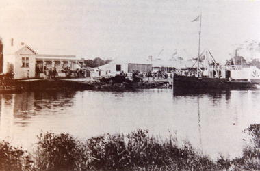
Photograph - P.S. Tanjil, Cornell F, 1880 c
Also new sepia print 10 x 15 cm. See also Peter Synan's book 'Highways of Water'Sepia photograph showing paddle steamer Tanjil at Latrobe Wharf. Swan Hotel on left and Victoria Hotel on right. Timber stacked on wharf. People on wharf and in small boats on river on left, taken from opposite side of Latrobe River. This scene is immediately downstream of present swing bridge on Latrobe River. Sale Victoriaboats and boating, jetties, hotels -
 Lakes Entrance Historical Society
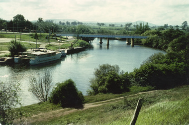
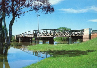
Photograph - Bridges, Murray Views Gympie, 1980
... Bridges Waterways Colour photograph showing swing bridge ...Photo printed on Jumbo card by Murray Views, Gympie QLDColour photograph showing swing bridge on Latrobe River, shows north facing side of bridge, willows on opposite bank on site of Latrobe River wharf, river running very high, two red gum trees in water on left. Longford Victoriabridges, waterways -
 Lakes Entrance Historical Society
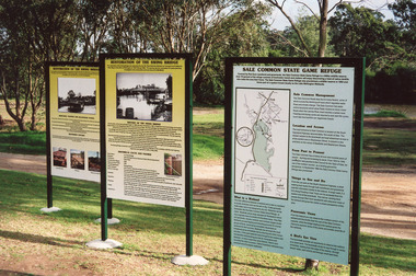
Photograph - Bridges, 2003
... Also thirteen other photographs showing bridge open ...Also thirteen other photographs showing bridge open and closed.Colour photograph showing information boards giving the history of the iconic bridge and its relationship to the Gippsland Lakes historic swing bridge over the Latrobe River. The South Gippsland Highway no longer uses the swing bridge since two new bridges have been built a little upstream on the Latrobe River. Longford Victoria.bridges, waterways, local history, display -
 Lakes Entrance Historical Society
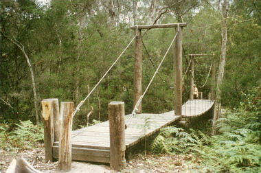
Photograph - Bridges, Fish Marie, 1995
... near Lakes Entrance, Victoria Photograph Bridges Fish Marie ...Colour photograph of the suspension bridge at Mississippi Creek picnic area in Colquhoun State Forest near Lakes Entrance, Victoriabridges, vegetation -
 Lakes Entrance Historical Society
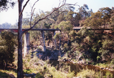
Photograph - Bridges, 1998
... . Nowa Nowa, Victoria, Photograph Bridges ...Re Heritage StudyColour photograph of the railway bridge over Boggy Creek, showing the bridge high above the waterway, rocky terrain and scrubby vegetation. Nowa Nowa, Victoria,bridges, waterways, transport -
 Lakes Entrance Historical Society
Photograph - Bridges, 1995
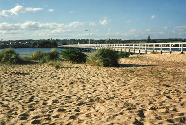
... Bridges Waterways Colour photograph of Cunninghame Arm ...Colour photograph of Cunninghame Arm Footbridge, looking towards the town. Lakes Entrance, Victoriabridges, waterways -
 Lakes Entrance Historical Society
Photograph - Bridges, 1995
... Bridges Waterways Colour photograph of Cunninghame Arm ...Colour photograph of Cunninghame Arm Footbridge, looking towards the town. Lakes Entrance, Victoriabridges, waterways -
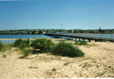
 Lakes Entrance Historical Society
Photograph - Bridges, 1995
... Bridges Waterways Colour photograph of Cunninghame Arm ...Colour photograph of Cunninghame Arm Footbridge, looking towards hummocks. Lakes Entrance, Victoriabridges, waterways -
 Bendigo Historical Society Inc.
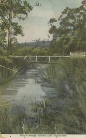
Postcard - Alice McGregor Postcard Collection, 1900 - 1920
Alice McGREGOR Born: 1908; unknown parents. Possibly adopted by the Salter family? Electoral Roll 1936: Highland Terrace Kangaroo Flat. Alice Mary Salter and William Robert Salter living together; presumed to be sister and brother. William Robert Salter was killed in a MVA in Bendigo in 1937 aged 26. In Victoria in 1938, Alice Mary Salter married James Thomas McGregor (born Victoria 1917, died Victoria 1983, buried Fawkner Cemetery) Lived: 1968; 22 Wade Street Golden Square Alice McGregor Died: 1999 aged 91 at Anne Caudle Centre, Bendigo Buried: Kangaroo Flat Cemetery See additional research. Postcard Album of Alice McGregor contained 86 post cards.Postcard Album of Alice McGregor containing 86 post cards. See 1400. Colour photo of a rustic bridge at Jubilee Lake, Daylesford, Victoria Stream running through bushland setting. PO stamp dated Dec 27, 1905 Addressed to Miss Stapleton, Arcade, Bendigo Sender unknown postcard, collector, alice mcgregor -
 Bendigo Historical Society Inc.
Postcard - Alice McGregor Postcard Collection, 1900 - 1920
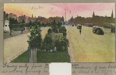
Alice McGREGOR Born: 1908; unknown parents. Possibly adopted by the Salter family? Electoral Roll 1936: Highland Terrace Kangaroo Flat. Alice Mary Salter and William Robert Salter living together; presumed to be sister and brother. William Robert Salter was killed in a MVA in Bendigo in 1937 aged 26. In Victoria in 1938, Alice Mary Salter married James Thomas McGregor (born Victoria 1917, died Victoria 1983, buried Fawkner Cemetery) Lived: 1968; 22 Wade Street Golden Square Alice McGregor Died: 1999 aged 91 at Anne Caudle Centre, Bendigo Buried: Kangaroo Flat Cemetery See additional research. Postcard Album of Alice McGregor contained 86 post cards.Postcard Album of Alice McGregor containing 86 post cards. See 1400. Colour photo of Princes Bridge from St Kilda Rd looking towards the city of Melbourne. Part of title has been cutout. Addressed to Miss M.J.E. Stapleton, Arcade, Bendigo Sender unknown Undated postcard, collector, alice mcgregor -
 Bendigo Military Museum
Certificate - CERTIFICATE, FRAMED WW1, Education Department Victoria, 1917
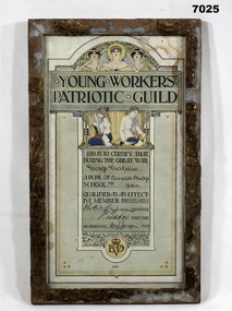
Information printed on Certificate; "Young Workers/ Patriotic Guild. This is to Certify that/During the Great War/............../A Pupil of .............../School No. .............../ Qualified as an effect/ ive member/ ..............Minister/ ...............Director/ Headmaster 191.............../ED/ 1911" Certificate - paper, dark blue print with colour illustrations and decorative scroll work. three women at top, two children below certificate title, below all print foliage. Handwritten - owners name and signatures on Certificate. Certificate damaged by water and dust. Frame - timber, with decorative plaster of paris moulding, gold paint. Moulding damaged with many sections missing with glass front and cardboard back.Handwritten in black ink: “George Graham/Arnold's Bridge/1664/ HSW Lawsaw/ ? Tate/ W.M. J. Jackson/ 1917”framed certificate, ww1, education dept victoria, accessories. -
 Bendigo Historical Society Inc.
Postcard - Alice McGregor Postcard Collection, 1900 - 1920
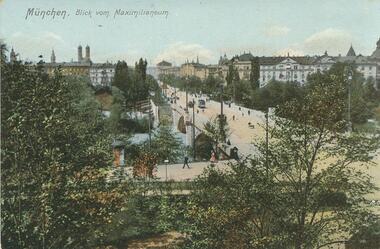
Alice McGREGOR Born: 1908; unknown parents. Possibly adopted by the Salter family? Electoral Roll 1936: Highland Terrace Kangaroo Flat. Alice Mary Salter and William Robert Salter living together; presumed to be sister and brother. William Robert Salter was killed in a MVA in Bendigo in 1937 aged 26. In Victoria in 1938, Alice Mary Salter married James Thomas McGregor (born Victoria 1917, died Victoria 1983, buried Fawkner Cemetery) Lived: 1968; 22 Wade Street Golden Square Alice McGregor Died: 1999 aged 91 at Anne Caudle Centre, Bendigo Buried: Kangaroo Flat Cemetery See additional research. Postcard Album of Alice McGregor contained 86 post cards.Postcard Album of Alice McGregor containing 86 post cards. See 1400 Colour photo of 'Blick von Maximilianeum' Munchen, (Germany) Street over a bridge with a tram and pedestrians. Trees in foreground and city buildings in background. kground No addressee, sender or date postcard, collector, alice mcgregor -
 Victorian Railway History Library
Cauchi, Mark, Rails by the sea, 2021
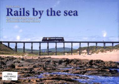
... Railroad construction - Victoria - history railroad bridges ...The remarkable story of Kilcunda's railway history on the Nyora to Wonthaggi branch line in Victoria.index, ill, maps, p.63.non-fictionThe remarkable story of Kilcunda's railway history on the Nyora to Wonthaggi branch line in Victoria.railroad construction - victoria - history, railroad bridges - victoria - history -
 Marysville & District Historical Society
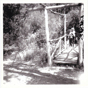
Photograph (Item) - Black and white photograph, 1960s
A black and white photograph of the wooden bridge at the Fruit Salad Farm in Marysville taken in the 1960s.A black and white photograph of the wooden bridge at the Fruit Salad Farm in Marysville taken in the 1960s.Bridge at/ Fruit Salad Farm 1960'smarysville, victoria, australia, fruit salad farm, accommodation, restaurant, photograph -
 Marysville & District Historical Society
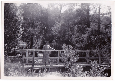
Photograph (Item) - Black and white photograph, 1954
A black and white photograph taken at the Fruit Salad Farm in Marysville in 1954.A black and white photograph taken at the Fruit Salad Farm in Marysville in 1954.Rosalie - 1954/ Marysville Fruit Salad Farm Bridgemarysville, victoria, australia, fruit salad farm, accommodation, restaurant, photograph -
 Flagstaff Hill Maritime Museum and Village
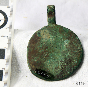
Horse Brass
When the ship Schomberg was launched in 1855, she was considered the most perfect clipper ship ever to be built. James Blaine’s Black Ball Line had commissioned her to be built for their fleet of passenger liners. At a cost of £43,103, the Aberdeen builders designed her to sail faster than the quick clippers designed by North American Donald McKay. She was a three masted wooden clipper ship, built with diagonal planking of British oat with layers of Scottish larch. This luxury vessel was designed to transport emigrants to Melbourne in superior comfort. She had ventilation ducts to provide air to the lower decks and a dining saloon, smoking room, library and bathrooms for the first class passengers. At the launch of Schomberg’s maiden voyage, her master Captain ‘Bully’ Forbes, drunkenly predicted that he would make the journey between Liverpool and Melbourne in 60 days. Schomberg departed Liverpool on 6 October 1855 with 430 passengers and 3000 tons cargo including iron rails and equipment intended the build the Geelong Railway and a bridge over the Yarra from Melbourne to Hawthorn. The winds were poor as Schomberg sailed across the equator, slowing her journey considerably. She was 78 days out of Liverpool when she ran aground on a sand-spit near Peterborough, Victoria, on 27 December; the sand spit and the currents were not marked on Forbes’s map. Overnight, the crew launched a lifeboat to find a safe place to land the ship’s passengers. The scouting party returned to Schomberg and advised Forbes that it was best to wait until morning because the rough seas could easily overturn the small lifeboats. The ship’s Chief Officer spotted SS Queen at dawn and signalled the steamer. The master of the SS Queen approached the stranded vessel and all of Schomberg’s passengers were able to disembark safely. The Black Ball Line’s Melbourne agent sent a steamer to retrieve the passengers’ baggage from the Schomberg. Other steamers helped unload her cargo until the weather changed and prevented the salvage teams from accessing the ship. Local merchants Manifold & Bostock bought the wreck and cargo, but did not attempt to salvage the cargo still on board the ship. They eventually sold it on to a Melbourne businessman and two seafarers. After two of the men drowned when they tried to reach Schomberg, salvage efforts were abandoned.32 In 1975, divers from Flagstaff Hill, including Peter Ronald, found an ornate communion set at the wreck. The set comprised a jug, two chalices, a plate and a lid. The lid did not fit any of the other objects and in 1978 a piece of the lid broke off, revealing a glint of gold. As museum staff carefully examined the lid and removed marine growth, they found a diamond ring, which is currently on display in the Great Circle Gallery.33 Flagstaff Hill also holds ship fittings and equipment, personal effects, a lithograph, tickets and photograph from the Schomberg. Most of the artefacts were salvaged from the wreck by Peter Ronald, former director of Flagstaff Hill. The Schomberg, which is on the Victorian Heritage Register (VHR S612), has great historical significance as a rare example of a large, fast clipper ship on the England to Australia run, carrying emigrants at the time of the Victorian gold rush. She represents the technical advances made to break sailing records between Europe and Australia. Flagstaff Hill’s collection of artefacts from the Schomberg is significant for its association with the shipwreck. The collection is primarily significant because of the relationship between the objects, as together they have a high potential to interpret the story of the Schomberg. It is archaeologically significant as the remains of an international passenger Ship. It is historically significant for representing aspects of Victoria’s shipping history and for its association with the shipwreck and the ship, which was designed to be fastest and most luxurious of its day Small brass horse harness disc 1½" in diameter. Slight verdigris and encrustation. Recovered from the wreck of the Schombergwarrnambool, shipwrecked-coast, flagstaff-hill, flagstaff-hill-maritime-museum, maritime-museum, shipwreck-coast, flagstaff-hill-maritime-village, schomberg, shipwrecked-artefact, clipper ship, black ball line, 1855 shipwreck, aberdeen clipper ship, captain forbes, peterborough shipwreck, ss queen, horse harness, horse brass -
 Ballarat Tramway Museum
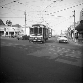
Photograph - Set of four black and white negatives of Ballarat trams, Warren Doubleday, 20-4-1968
Photos 25-4-69, of: .1 - Ballarat 17 at Stones Corner with Caltex Service Station in the background. Tram leaving Main Road before joining Bridge St. .2 - No. 28 running from Bridge Street into Sturt Street with a "Trotting at Bray Raceway Tonight" Auxillary board. Tram has the destination of Gardens via Sturt St West. In the background are the Big W and the Dickins Store. .3 - Tram 43 on "0" road at the SEC Ballarat Depot. .4 - Tram 13 at the Gardens Loop in Wendouree Parade. Tram has an ANA Hospital and Medical Benefits (Australian Natives Association) Advertising Board.Yields information about the operation of the Ballarat tramway system that was operated by the State Electricity Commission of Victoria.Set of four black and white negatives of Ballarat Tramways, 120 size. ballarat, trams, tramways, sturt street, tram 17, main road, bridge street, tram 28, bray raceway, dickins, big w, tram 13, ana health, wendouree parade, gardens loop, depot, tram 43, stones corner, caltex -
 Kew Historical Society Inc
Work on paper - Sepia Wash & Ink, G B Richardson, Creek and Old Watering Stage, on the Yarra, East Collingwood, 1854, 1854
Blind Creek was located between the Abbotsford Convent and what is now the Collins Bridge in Studley Park. In an 1858 map of East Collingwood by Clement Hodgkinson, in the State Library of Victoria, one can see how the creek was originally a significant landmark in Collingwood; remaining vacant land until a barrel drain enclosed it. The area was later filled in, surveyed and developed. The position where Blind Creek entered the Yarra was in the immediate vicinity of Hodgson’s Punt, which had linked Kew to the other side of the Yarra from 1839. The Punt was purchased by the Colonial Government in 1852 and was in use until the opening of the Studley Park Road (Johnston Street) Bridge in 1858 made its continued use redundantThe point of view selected by the artist for the watercolour is from the banks of Blind Creek in East Collingwood, looking across the Yarra to the Kew side of the river.Inscribed verso 'Creek and Old Watering stage, on the Yarra East Collingwood 1854 / Trees, stage, &c have long since disappeared / [Artist Signature] / FT 110 / Creek itself now being filled in 1903.gb richardson, blind creek - abbotsford, yarra river - abbotsford (vic) - kew (vic), colonial artists, australian art - 19th century, george bouchier richardson -
 Melbourne Tram Museum
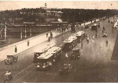
Photograph - Photograph Card, Kelly Collection, View Productions, Princes Bridge / Batman Ave tram terminus, Photo c1920
... , titled "On the Princes Bridge, circa 1920, Melbourne, Victoria... "On the Princes Bridge, circa 1920, Melbourne, Victoria, Australia". Has ...Photograph Card - folded card, blank inside of Cable Trams, motor cars, pedestrians crossing Princes Bridge over the Yarra River with the Princes Bridge / Batman Ave tram terminus with a shelter in the background. Shows five cable tram sets. Has railway signals and Government House in the view. Produced by View Productions GPO Box 1858 Sydney, from the Kelly Collection, titled "On the Princes Bridge, circa 1920, Melbourne, Victoria, Australia". Has the Publishers logo on the rear.trams, tramways, princes bridge, batman ave, swanston st, cable trams, shelters -
 Melbourne Tram Museum
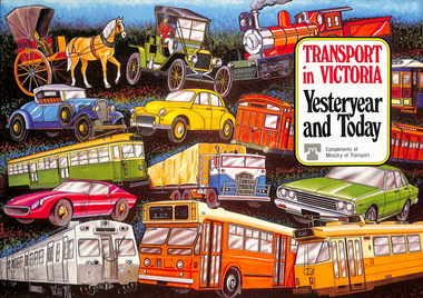
Book, Ministry of Transport, "Transport in Victoria - Yesteryear and Today", 1980
Pamphlet or Book - 20 pages, full colour printed on gloss paper, centre stapled titled "Transport in Victoria - Yesteryear and Today", published by the Ministry of Transport giving an outline of Victoria's transport history from 1834. Provides a short history of the state transport system, railways, roads, trams, Metropolitan planning, the Bland report, social changes, the underground loop, transport interchanges, West Gate Bridge, Roads and Freeways, transport inquiry of 1980 and environmental changes resulting from motor cars. 2nd copy added 14-5-2016 from the estate of Charles Craig.trams, tramways, minister for transport, railways, trb, crb, murla, planning, history -
 Melbourne Tram Museum
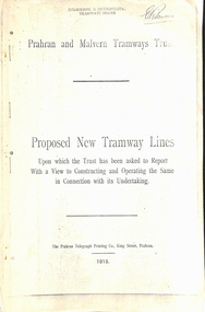
Document - Report, Prahran & Malvern Tramway Trust (PMTT), Proposed New Tramway Lines, Original 1915
Photocopy - 16 sheets report - "Proposed New Tramway Lines - upon which the Trust has been asked to Report With a View of Constructing and Operating the Same in Connection with its Undertaking" by the Prahran Malvern Tramways Trust - dated August 1915. Reports on possible tramways: Toorak Road - Prahran to Burke Road Hawthorn - 1.85miles Glen Eira Road - Murrumbeena Railway station to Barkly St St Kilda - 5 miles Brighton and Moorabbin - Glen Huntly Road to Sandringham - 7.4 miles South Melbourne and St Kilda - Princes Bridge - 4.85 miles Princess St and Willsmere Road Kew - 1 mile. Tooronga Road Malvern - 1 mile Brighton Road St Kilda - .83 miles Looks at the population required to justify tramways, income per head, cost of construction and operation, each line and how it fits with the necessary criteria for a profitable operation. Appendix looks at existing tramways, population statistics, and tramways performance in other cities. Photocopy made from original documents. .1 - Original copy from donation of Norm Cross added 10-9-2018 - complete with stapled blue cover, and fold out appendix sheet.Has the stamp on the rear of the first page "The property of the Tramway Museum Society of Victoria Ltd." On the top right hand corner of the second page, has the stamp "Melbourne & Metropolitan Tramways Board"trams, tramways, pmtt, new tramway, toorak rd, glen eira, south melbourne, st kilda, kew, moorabbin, sandringham -
 Melbourne Tram Museum
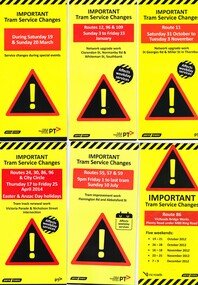
Pamphlet, Yarra Trams, "Important Tram Service Changes", 2012 to 2016
Set of 24 pamphlets, DL size when folded, Full colour, titled "Important Tram Service Changes", giving details of interruptions to the tram system due to Roadworks or events. Have been number .1 to .3 and .5 to .26. Have the logos of Yarra Trams, VicRoads, PTV, .1 - Grand Prix 2016 .2 - Roadworks - Clarendon St, Normandy Road and Whiteman St Southbank, track reconstruction of Southbank or Port junction accessible tram stops, 3/1/16 to 15/1/16 - put in siding for the Restaurant Tram .3 - Route 11 - reconstruction of junction into Preston Workshops - Oct. 2015 .5 - Victoria Parade and Nicholson St intersection reconstruction - April 2014 .6 - Reconstruction of junction - Abbotsford St and Flemington Road - July 2016 .7 - Route 86, VicRoads bridge works - Plenty Road - Oct. to Dec. 2012 .8 - Route 70, Swan St, Burnley track renewal - June 2012 .9 - as for .7 .10 - Route 70, Riversdale Road, Camberwell track renewal, Nov. 2012 .11 - Chapel and Carlisle Sts, Trackwork - June 2013 .12 - ditto .13 - Route 86 - Gertrude and Smith Streets Collingwood .14 - Route 78 and 79 - track renewal Chapel St Sept. 2013 .15 - Elizabeth St track reconstruction and accessible tram stops - Oct. 2013 - see also Reg Item 859. .16 - Tram track renewal, Mt Alexander Road - Ormond Road and Kent St - Routes 55 and 59 - Feb. 2014 .17 - St Kilda Road, between Southbank Blvd and Park St - Feb. 2014 .18 - Overhead Renewal Camberwell depot - March 2014 .19 - Gilbert Road and Miller St - track and overhead renewal - July 2014 .20 - Tram stop works - Melbourne and Olympic Park - August 2014 .21 - Tram stop works - Melbourne Town Hall - Collins St - August 2014 .22 - Matthews Ave, Airport West, route 59 - September 2014 .23 - Tram stop works, Flinders St - Sept. 2014 .24 - Tram stop works - Bourke and Swanston St - Oct. 2014 .25 - Tram stop works - Flinders Jan. 2015 .26 - Elizabeth St works - May and July 2013trams, tramways, grand prix, trackwork, overhead, southbank, tram stops, route 11, victoria parade, nicholson st, preston workshops, abbotsford st, flemington rd, route 86, chapel st, carlisle st, gertrude st, smith st, riversdale rd, swan st, route 70, route 55, route 59, mount alexander rd, st kilda rd, camberwell depot, gilbert rd, miller st, collins st, route 59, matthews ave, flinders st, port junction -
 Melbourne Tram Museum
Document - Report, Road Board, "Report on Traffic Congestion", 1919
Report - 26 pages, printed, contained and stapled within a grey "Roneo Numeralpha System" folder, titled "Report on Traffic Congestion", containing a Victorian Parliamentary Report, dated 1919 with titled "Report of Board appointed to investigate the problem of relieving congestion of traffic in Melbourne." Full title "Report of Board Appointed to Investigate the problem of Relieving Congestion of Traffic in Melbourne" The Board or "Traffic Board" comprised 5 representatives of Councils, MMTB, Railways and the Public Works Department includes comments on growth of Melbourne, railways, tramways, new arterial roads, subways, new bridge at Spencer St, regulation of street traffic, looks at new tramway routes, hours works and provides a summary of recommendations including drawings for new arterial roads, graphs and roads / tramway layouts in two chain wide roads. Note: This document is available as a pdf on the Parliament of Victoria website. Second copy - unbound as printed, stapled on the left hand side, from McComb collection, box 10 - added 5/1/2017. added a 2nd copy from Russell Jones (28/05/22). Poor quality copy.Has in ink on the bottom edge "17th June 1919", Copy 2 - "H. Lormer"? in ink in the top right hand corner.trams, tramways, mmtb, general scheme, tramways, development, parliament, spencer st, railways, finances, construction, traffic control