Showing 171472 items
matching will street
-
 Eltham District Historical Society Inc
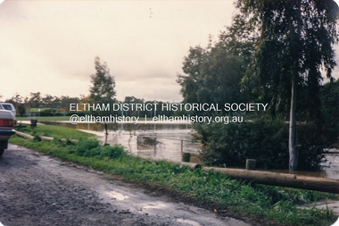
Photograph, Diamond Creek floodwater, Eltham
Four colour photographs of Diamond Creek floods in Susan Street and Dalton Street area. 1. Floodwater of Diamond Creek spreading towards Susan Street over the oval 2. Floodwater of Diamond Creek spreading towards Susan Street over the oval 3. Diamond Creek Trail from Dalton Street 4. Diamond Creek Trail from Dalton Streetdiamond creek, floods, etham, dalton street, susan street -
 Bendigo Historical Society Inc.
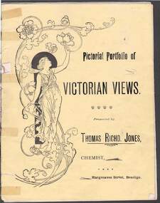
Document - PICTORIAL PORTFOLIO OF VICTORIAN VIEWS
Yellow covered nine page booklet containing 19th Century views of Bendigo and Ballarat presented by Thomas Richard Jones, Chemist of Hargreaves Street Bendigo. Art Noveau figure of woman on front cover. Inside cover features T R Jones Dispensing Chemist and Druggist printed beside man holding a horse. List of Veterinary products supplied by Jones. Farmer's requisites included Strychnine, Toxa, Phosphorus, Poisoined wheat, Bi-sulphide of Carbon. Egg preserving fluid and milk preserving powder Rennet and butter colouring along with Drenches and Cattle medicenes supplied. View No1. Moorabel Falls Ballarat. View No 2. Statues of Leda and Spring Ballarat. View No 3. A Giant Palm Bendigo. View No 4. View from St Paul's Bendigo. View No 5. Unveiling 'The first Public Statue' Bendigo P/Office in background. View No 6. Statue Presented to the City of Bendigo by Cr Harkness. [Reclining greek beside dog fighting lion] View No 7. 'On the Campaspe, near Bendigo. View No 8 The Pine Avenue, Rosalind Park. View No 9. Scenes on Lake Wendouree, Ballarat. View No 10. Statuary in The Botanical Gardens Ballarat. View No 11. Statues of Burns & Moore Ballarat. View No 12. Botanical Gardens, Ballarat. Inside back cover features list of T R Jones products. Outside back cover features advertisement for T R Jones Universal Corn Cure, and Jone's Compound Pectoral Balm.Printed by Periodicacls Publishing Co, 21 Elizabeth Street Melbourne.bendigo, parks and gardens, bendigo chemist and local views. -
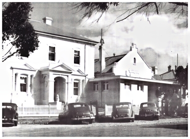 Northern District School of Nursing. Managed by Bendigo Historical Society Inc.
Photograph - Lister House in Rowan Street, 1950
The Northern District School of Nursing opened in 1950 in to address the issues around nurse recruitment, training and education that had previously been hospital based. The residential school was to provide theoretical and in-house education and practical training over three years. The students would also receive practical hands-on training in the wards of associated hospitals. The Northern District School of Nursing operated from Lister House, Rowan Street, Bendigo. It was the first independent school of nursing in Victoria and continued until it closed in 1989.Lister House in Rowan Street, Bendigo - NDSN large black and white photo with cars parked out the frontndsn, nursing, lister house, bendigo -
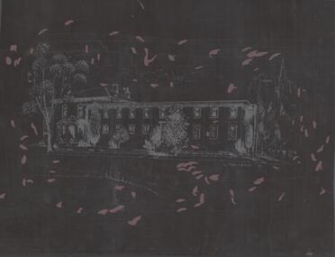 Northern District School of Nursing. Managed by Bendigo Historical Society Inc.
Photograph - Negative of pencil drawing of NDSN Lister House, Rowan Street, Bendigo
The Northern District School of Nursing opened in 1950 in to address the issues around nurse recruitment, training and education that had previously been hospital based. The residential school was to provide theoretical and in-house education and practical training over three years. The students would also receive practical hands-on training in the wards of associated hospitals. The Northern District School of Nursing operated from Lister House, Rowan Street, Bendigo. It was the first independent school of nursing in Victoria and continued until it closed in 1989.8593.3 Negative of photograph of a pencil drawing of NDSN Lister House, Rowan Street, Bendigo by C. Samson 1981.ndsn, nursing -
 The Beechworth Burke Museum
Photograph, c1900
Taken in Beechworth c1920, this photograph was taken from the tower of Christ Church (Anglican) looking down at Ford Street. Black and white rectangular postcard. Obverse: Beautiful Beechworth (Vic) 1800 ft. above Sea Level- Ford Street (Looking East) Copyright. F Foxcroft Photo. Reverse: AO3104 Post Cardbeechworth, ford street, burke museum, post card, photograph, 1920, church tower, anglican church, church -
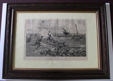 Beechworth RSL Sub-Branch
Picture printed, Saving Amiens
Print black and white in wooden frame, at bottom of print the words in large font "SAVING AMIENS" / " A brilliant Bayonet Charge by the 9th Australian Brigade" Ornately carved wooden frame with Gold inlay on the inner edge closest to the glass with off white mounting board. The print appears to sit loosely in the frame. The picture is signed by F. Mantania in the bottom left corner and on the picture mounting board "by F. Mantania, R. J." centered on the top mounting board is "Copyright published 15th May 1919 by "The Sphere and Tatler", LTD, 6, Great New Street E.C.4Copyright published 15th May 1919 by "The Sphere and Tatler", LTD, 6, Great New Street E.C.4 -
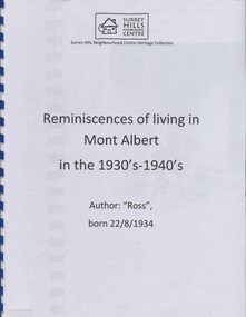 Surrey Hills Historical Society Collection
Book, Reminiscences of living in Mont Albert in the 1930s - 1940s
This publication is a collection of reminiscences in Mont Albert including the Hamilton Street Shopping Centre, the trains, how the author spent his time after school, and games played during the war.This publication is a collection of reminiscences in Mont Albert including the Hamilton Street Shopping centre, the trains, how the author spent his time after school, and games played during the war.high street, mont albert, trafalgar street, hamilton street, zetland road, st. georges avenue, brehaut's engineering works, transport, horse-drawn vehicles, mont albert station, railway stations, inglisby road, whitehorse road, boot and bicycle repairer, mont albert shopping centre, (mr) - tarry, (mr) - anderson, hairdresser, grocer, (mr) - harrison, (mr) - murphy, fuel merchant, (mr) - salmon -
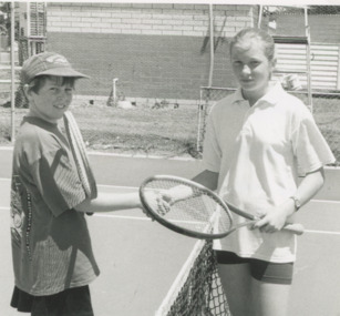 Lakes Entrance Historical Society
Photograph - Daniel Connelly and Catherine Brew, Lakes Post Newspaper, 1/12/1995 12:00:00 AM
Daniel Connelly and Catherine Brew at Saturday competition on Rowe Street court Lakes Entrance Victoria. Also a black and white group photograph of junior tennis players from Lakes Entrance, Bruthan and Buchan who played in the Saturday competition number 03987.2 size 10 x 15.5Black and white photograph of Junior tennis players Daniel Connelly and Catherine Brew at Saturday competition on Rowe Street court Lakes Entrance Victoria sports, tennis, clubs, recreation -
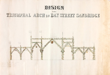 Port Melbourne Historical & Preservation Society
Plan - Triumphal Arch, Bay Street, Sandridge, Borough of Sandridge, 1867
Drawn for the Council Committee for reception of Prince Alfred Oct 1867Design for triumphal arches in Bay Street, Sandridge (with measurements for Fountain Inn, Bridge Street and Liardet Street locations) probably 1867 - visit of Prince AlfredMeasurements noted in pencil.royal visits and occasions, celebrations fetes and exhibitions, prince alfred, bay street -
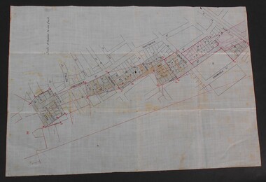
 Port Melbourne Historical & Preservation Society
Plan - Metalling and channelling Evans Street from Ingles Street to Boundary Street, 14 Mar 1893
Specifications (94.1) and Plan (94.2) for metalling and channelling Evans Street from Ingles Street to Boundary Street . Loan Works 1893. Plan number 8.Both signed by J.J. Bartlett. (Mayor).engineering - roads streets lanes and footpaths, town planning, town clerks, mayors, arthur victor heath, james john bartlett -
Port Melbourne Historical & Preservation Society
Plan - Metalling and channelling Evans Street from Ingles Street to Boundary Street, 14 Mar 1893
Specifications (94.1) and Plan (94.2) for metalling and channelling Evans Street from Ingles Street to Boundary Street . Loan Works 1893. Plan number 8.Both signed by J.J. Bartlett. (Mayor).engineering - roads streets lanes and footpaths, town planning, town clerks, mayors, arthur victor heath, james john bartlett -
 Whitehorse Historical Society Inc.
Photograph, Hill Street, Blackburn, 1/06/2003 12:00:00 AM
Coloured photograph of Hill Street, Blackburn showing tree lined narrow street with no footpaths. - Private street classified by National Trust as part of the Bellbird area.bellbird area, hill street, blackburn, national trust of australia (victoria) -
 Bendigo Historical Society Inc.
Document - WES HARRY COLLETION: SURVEORS MAP ON LINEN OF HONEySUCKLE AND THISTLE STREETS
A surveyor's map to scale 4 chains to 1 inch of Honeysuckle & Thistle Streets, between Alley Street and Clark Street Unknown purpose of the plan - undated -
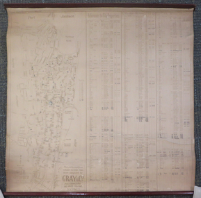 Federation University Historical Collection
Document - Chart, Port Jackson, Reference to City Properties, 1930s
This chart was compiled using information compiled by Gray & Co Auctioneers of 135 Pitt Street, Sydney and contains information relating to the streets of Port Jackson with the property numbers and dates of sale until 1930, the dimensions of the properties and the purchase prices. It was most likely part of the School of Mines Ballarat collection.This dirty cream chart is of the streets of Port Jackson with the property numbers and dates of sale until 1930, the dimensions of the properties and the purchase prices. Some property numbers have been added by hand. It has timber ends, top and bottom.Some information has been added by handport jackson, reference to city properties, chart, gray & co auctioneers, sydney, kenneth craigie sydney, property information -
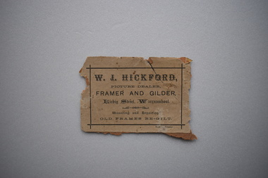 Warrnambool and District Historical Society Inc.
Label, Hickford, Early 20th century
Walter John Hickford, painter and businessman, was Mayor of Warrnambool 1895-6-7 and President of the Committee that organised the Warrnambool Industrial and Art Exhibition of 1896-7. A skilled decorative artist, he carried out art work in private homes, businesses and churches. His shop in Liebig Street supplied paint materials for households, tradesmen and artists. Hickford Parade is named after Walter Hickford. This is an original label from a picture frame and is of considerable interest, as Walter John Hickford was a prominent citizen and businessman in Warrnambool in the 1860sFaded brown rectangular label with black text and border adhered to a piece of brown paper.W.J.HICKFORD, picture dealer, framer and gilder. Liebig Street, Warrnambool. Mounting and Repairing. OLD FRAMES RE-GILTwalter john hickford, painter, hickford parade, warrnambool -
 The Beechworth Burke Museum
Photograph, 1865
Taken in Beechworth 1865, this photograph depicts a number buildings looking down Ford Street. The left side of image shows the Bank of Australia, the Post Office, the Bank of Victoria, and Howard Bookseller. The right side depicts the Oriental Bank, Albion Hotel, the Bank of NSW, and the First church in Beechworth which was the Methodist Church on the hill.Black and white rectangular photograph. Image is printed on matt photographic paper with a cardboard backing. Obverse: ALBION HOTEL, HOWARD BOOKSELLER Reverse: STREETS / (in pencil) FORD ST, BEECHWORTH / VICTORIA 1865 19972743 A02743 beechworth, ford street, bank of victoria, burke museum, 1865 -
 Kew Historical Society Inc
Plan, Melbourne & Metropolitan Board of Works : Borough of Kew : Detail Plan No.1581, 1904
The Melbourne and Metropolitan Board of Works (MMBW) plans were produced from the 1890s to the 1950s. They were crucial to the design and development of Melbourne's sewerage and drainage system. The plans, at a scale of 40 feet to 1 inch (1:480), provide a detailed historical record of Melbourne streetscapes and environmental features. Each plan covers one or two street blocks (roughly six streets), showing details of buildings, including garden layouts and ownership boundaries, and features such as laneways, drains, bridges, parks, municipal boundaries and other prominent landmarks as they existed at the time each plan was produced. (Source: State Library of Victoria)This plan forms part of a large group of MMBW plans and maps that was donated to the Society by the Mr Poulter, City Engineer of the City of Kew in 1989. Within this collection, thirty-five hand-coloured plans, backed with linen, are of statewide significance as they include annotations that provide details of construction materials used in buildings in the first decade of the 20th century as well as additional information about land ownership and usage. The copies in the Public Record Office Victoria and the State Library of Victoria are monochrome versions which do not denote building materials so that the maps in this collection are invaluable and unique tools for researchers and heritage consultants. A number of the plans are not held in the collection of the State Library of Victoria so they have the additional attribute of rarity.Original survey plan, issued by the MMBW to a contractor with responsibility for constructing sewers in the area identified on the plan within the Borough of Kew. The plan was at some stage hand-coloured, possibly by the contractor, but more likely by officers working in the Engineering Department of the Borough and later Town, then City of Kew. The hand-coloured sections of buildings on the plan were used to denote masonry or brick constructions (pink), weatherboard constructions (yellow), and public buildings (grey). The streets and built structures in this plan were surveyed in 1903 and released to contractors in 1904. In addition to the designation of building types by colour, the plan includes detailed descriptions of land use and ownership. While many buildings remain from this period, a number of the buildings represented have been demolished including the original Kew Town Hall, and the Congregational and Roman Catholic churches in Walpole Street. While the mansion ‘Illapa’ in Princess Street is still extant – now part of ‘Rylands’ – the neighbouring mansion ‘Elsmere’ was demolished some decades ago. Rivalling Illapa and Elsmere in size were two mansions in Walpole Street, one named on the plan as ‘Gnarlbine’. Over time, Kew Junction and the south side of High Street have been reconfigured and widened, so that the commercial buildings on the corner of Princess and High Street no longer exist. A surprising feature of this part of central Kew to the northwest of Kew Junction is the amount of vacant land. In a number of cases, this land is noted by the contractor as used for vegetable gardens.melbourne and metropolitan board of works, detail plans, maps - borough of kew, mmbw 1581, cartography -
 Kew Historical Society Inc
Plan, Melbourne & Metropolitan Board of Works : Borough of Kew : Detail Plan No.1568, 1905
The Melbourne and Metropolitan Board of Works (MMBW) plans were produced from the 1890s to the 1950s. They were crucial to the design and development of Melbourne's sewerage and drainage system. The plans, at a scale of 40 feet to 1 inch (1:480), provide a detailed historical record of Melbourne streetscapes and environmental features. Each plan covers one or two street blocks (roughly six streets), showing details of buildings, including garden layouts and ownership boundaries, and features such as laneways, drains, bridges, parks, municipal boundaries and other prominent landmarks as they existed at the time each plan was produced. (Source: State Library of Victoria)This plan forms part of a large group of MMBW plans and maps that was donated to the Society by the Mr Poulter, City Engineer of the City of Kew in 1989. Within this collection, thirty-five hand-coloured plans, backed with linen, are of statewide significance as they include annotations that provide details of construction materials used in buildings in the first decade of the 20th century as well as additional information about land ownership and usage. The copies in the Public Record Office Victoria and the State Library of Victoria are monochrome versions which do not denote building materials so that the maps in this collection are invaluable and unique tools for researchers and heritage consultants. A number of the plans are not held in the collection of the State Library of Victoria so they have the additional attribute of rarity.Original survey plan, issued by the MMBW to a contractor with responsibility for constructing sewers in the area identified on the plan within the Borough of Kew. The plan was at some stage hand-coloured, possibly by the contractor, but more likely by officers working in the Engineering Department of the Borough and later Town, then City of Kew. The hand-coloured sections of buildings on the plan were used to denote masonry or brick constructions (pink), weatherboard constructions (yellow), and public buildings (grey). Plan No.1568 covers the area bounded by Cotham Road, John Street, Sackville Street, and Edward Street. Alfred Street and Rowland Street are in shown in the middle of the plan. The two most notable buildings shown are ‘St Helliers’, the home of the Dumaresq family, and St Hilary’s Church and school. While the colours used to indicate St Hilary’s are grey as in other civic/public buildings, the first St Hilary’s Anglican Church was at this stage constructed in weatherboard. At the left of the plan, facing Sackville Street is a house named ‘Glencara’. The 1988 ‘Kew Conservation Study’ recorded that “The first documentary evidence of this house comes from Rate Books which record that in 1893 a Mrs Treadway was the owner of this building with an N.A.V. of £81? At that date the occupier of the house was Charles B. Kelly, a clerk, while by 1910 Kelly had become the owner of the property described in that year ‘as a six-roomed stone, brick and wood house with stables and outbuildings’”. Contrary to this description, the 1905 plan indicates that the house was entirely constructed of masonry.melbourne and metropolitan board of works, detail plans, mmbw 1568 -
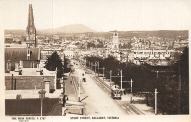 Ballarat Tramway Museum
Postcard - Sturt Street Ballarat, Victoria, Rose Stereograph Co, 1920s?
Photo taken from the City Fire Brigade station at the corner of Sturt and Raglan Streets, looking east towards Mount Warrenheip. Has an eastbound ESCo tram. Photo shows the overhead structures, Harry Davies & Co. Drapers Importers, Ballarat Town Hall and the general view of the city. On the rear is a large Rose symbol and publisher details.Yields information about Sturt St during 1920sPostcard - Rose Series P 1717, Sturt Street looking east. Second copy - cigarette card size - 63mm x 87mmHas an address in Macarthur St, Ballarat on rear. Second copy has in ink "To Ken from Paul Kiwi4755"ballarat, sturt st, fire watch tower, harry davies -
Canterbury History Group
Photograph - Garden of "Roquebrune" corner of Canterbury Road and Gascoyne Street Canterbury, c1920
"Roquebrune" built in 1912 or 1914 by G.H.Tarrrant and demolished in 1971 to make way for the Baptist Nursing Home on the corner of Canterbury Road and Gascoyne Street Canterbury. Now apartmentsGarden and side of the house "Roquebrune" built in 1912 or 1914 by G.H.Tarrrant and demolished in 1971 to make way for the Baptist Nursing Home on the corner of Canterbury Road and Gascoyne Street Canterbury. Now apartmentscanterbury, canterbury road, gascoyne street, roquebrune, edwardian style, baptist nursing home, aged people, nursing homes, garden -
 Surrey Hills Historical Society Collection
Work on paper - Photograph, Nethercourt Private Hospital, Surrey Hills, c 1924, 1924
Notes from a previous collection coordinator indicate that Miss Lucy Musselwhite (Lillywhite) opened the hospital in 1914 and Matron Eliza Tank took it over in 1921 and named it Nethercourt Private Hospital. However recent research suggests that Miss Musselwhite (name confirmed) moved from Tooronga to Wilson Street some time between 1903 and 1909. She and her mother Elizabeth are listed in the 1909 electoral rolls in Wilson Street and Lucy's occupation is given as nurse. (It is of course possible that the property was a residence only at this time and later opened as a private hospital.) The name Nethercourt was used prior to Matron Eliza Tank taking over. Her daughter Irene was also a nurse at Nethercourt. Lucy Musselwhite was born in 1873 in Hampshire. She married Henry James Dore in later life and lived in Brenbeal Street, Balwyn. She died in 1955. In 1930 / 1935 Matron Tank transferred the hospital to 219-223 Union Road. Later it was known as Norwich Hall / St Jude's. Mosgiel Hospital in Mont Albert Road also opened in 1924. After this time home births became less common. Nethercourt Hospital closed in the 1960s.Small hospitals such as this one were primarily used for midwifery, preceding the development of larger centralised general hospitals. Black and white photo of Nethercourt Private Hospital at 11 Wilson Street in c 1924 taken from the street in winter. The building is Victorian in style; block-fronted with lacework detail to the verandah and has 2 chimneys. It is set behind a wooden picket fence behind which is a well-manicured hedge which appears to have been grown across the front entrance gate.nethercourt private hospital, midwifery, hospitals, matron eliza tank, miss lucy musselwhite, miss irene tank, mrs irene anderson -
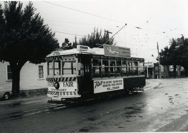 Ballarat Tramway Museum
Photograph - Black & White Photograph/s, Robert Green, 28/03/1970 12:00:00 AM
Black and white photograph of SEC Bendigo Birney No. 28 decorated for the Centenary Easter Fair, in Arnold St. at the corner of MacCrae Street, Bendigo, Saturday 28 March 1970. Photo by R.W. Green. Tram has destination of "Nth Bendigo", sign on front dash panel "Easter Fair Centenary" and on side panel "Visit the Joss House, Eaglehawk Museum, Rosalind Park, Central Deborah Mine by Tram". Photo taken on a rainy day. Roof advertisement SEC - "Everything's fine in my all Electric Kitchen"On rear in black ink "Bendigo Birney No. 28 decorated for the Centenary Easter Fair in Arnold Street at the corner of MacCrae Street. / Saturday 28 March 1970." Stamped on rear of photo in black ink "R.W. Green / Copyright Reserved / No. . . ." Paper has a stamp "H429" in blue green ink.trams, tramways, easter fair, arnold st, decorated trams, tram 28 -
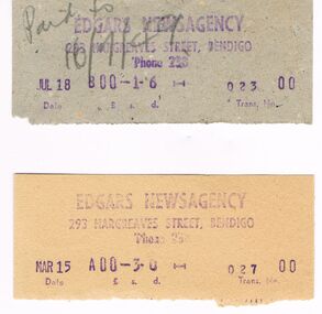 Bendigo Historical Society Inc.
Memorabilia - EDGARS NEWSAGENCY RECEIPTS, 1949
Edgar's Newsagency was situated on the corner of Hargreaves Street and Killians Walk. It later became POwney's Newsagency and then The Athletes Foot.Edgars Newsagency Receipts: A collection of receipts (9) in cream, grey and beige coloured card. In blue ink is Edgars Newsagency, 293 Hargreaves Street, Bendigo Phone 238. The date, amount and transaction no. Box 625business, retail, newsagency, edgars newsagency. hargreaves street -
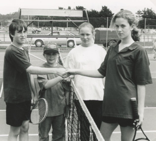 Lakes Entrance Historical Society
Photograph - Bryden Stron, Matt Jennings, Katherine Brew and Bree Waters, Lakes Post Newspaper, 1/11/1995 12:00:00 AM
Bryden Stron, Matt Jennings, Katherine Brew and Bree Waters on Rowe Street tennis court, Football ground in background Lakes Entrance VictoriaBlack and white photograph of Junior tennis players Bryden Stron, Matt Jennings, Katherine Brew and Bree Waters on Rowe Street tennis court, Football ground in background Lakes Entrance Victoriasports, tennis, clubs, recreation -
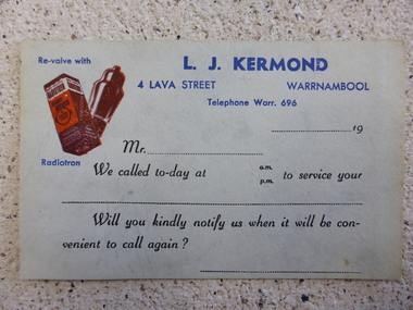 Warrnambool and District Historical Society Inc.
Document, L J Kermond card, 1950s
This is a service calling card from L.J.Kermond, a radio and electrical dealer and a servicer of these items. He operated from 4 Lava Street and later from 153A Lava Street and the dates found for this business are the 1950s and 60s. He later operated from Fairy Street and was well known in the district for his work in outside broadcast.This card is of interest as an example of the type used by servicing departments of business in Warrnambool in the 1950s and 60s. This is a grey coloured card (lightweight cardboard) used as a service call card by the radio and electrical service firm of L.J.Kermond. It is printed in blue and black type and has a red image of a battery and a valve. ‘Re-Valve with L.J.Kermond, 4 Lava Street, Warrnambool, Telephone Warr. 696, …..19. Mr ……., We called to-day at a.m./p.m. to service your ….. Will you kindly notify us when it will be convenient to call again?’l.j.kermond, warrnambool, kermonds electrical warrnambool, kermonds radio -
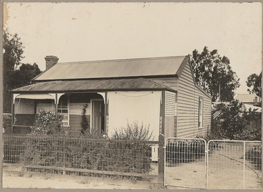 Bendigo Historical Society Inc.
Photograph - T C WATTS & SON COLLECTION: CREEK STREET, BENDIGO, 1930
Herbert Allan Unwin (1898-1958) lived at 171 Creek Street in 1928. In 1924 he had been listed as living at 78 Gladstone Street. After selling the Creek Street property, he moved to 629 Hargreaves Street. Herbert was a labourer who married Caroline Struggell in 1920.Black and white photographs (2) mounted on rectangular brown board. House, weatherboard, corrugated iron roof, curved verandah roof, trellis at ends of verandah, 2 canvas blinds on verandah, woven crinkled wire fence. On back of photo ' Unwin, Creek Street, £420 plus sewer' Date stamp 11 April 1930.Frank A. Jeffree, Bendigobendigo, business, t c watts & son -
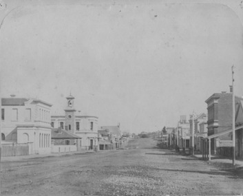
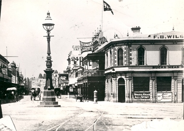 Federation University Historical Collection
Photograph - Black and White, Bridge Street Ballarat , c1890, c1890
The original of this image is held by the State Library of Victoria.Copy of a black and white photograph of Bridge Street Ballarat from the corner of Grenville Street and Sturt Street. The photo shows a street lamp in the middle of the intersection, fire hydrant, Yeoman's flag, tram tracks, and horse drawn vehicles.bridge street ballarat, sturt street ballarat, grenville street ballarat,, f.b. wilson, buck's head hotel -
Port Melbourne Historical & Preservation Society
Photograph - Albion Hotel, Evans Street, Port Melbourne, Meredith Turnbull, Dec 1996
Meredith TURNBULL photographed this series in 1996 to record the rapidly changing streetscape, which had already had a number of old houses replaced by concrete two-storey structures under the State government's urban consolidation policyFrom a series of 70 colour photos recording all buildings in Evans Street from Graham Street overpass to Ingles Street, as photographed from the railway reservation, by Meredith TURNBULL in December 1996 - Raglan Street and Albion HotelHouse numbers noted on backbuilt environment - domestic, built environment - commercial, business and traders - hotels, meredith turnbull, albion hotel -
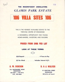 Ringwood and District Historical Society
Flyer, Land Sale Brochure, Glamis Park Estate (Wantirna, Vic.) - 1959
Street name Carnarvon Avenue on the subdivision plan became Selkirk Avenue at some stage during or subsequent to development of the Estate.Bi-folded advertisement for sale of residential allotments, including summary of subdivision features and local facilities.Subdivision includes Wantirna streets - Wantirna Road, Carnarvon Avenue, Inchcape Avenue, St Thomas Avenue, St Davids Drive, Dudley Avenue, Angus Avenue. Agents - A.W. Dickson, 136 Whitehorse Road, Ringwood, Telephone WU 6007, WU 7016, A.H. WU 6868. D. & J. Walker, 18 Junction Street, Ringwood, Telephone WU 6516 (all hours). -
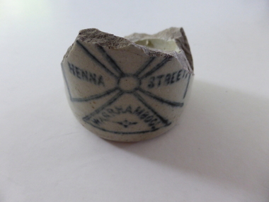 Warrnambool and District Historical Society Inc.
Bottle, Soft Drink Bottle Darby - broken, C 1890
Alfred Darby operated a soft drink factory in Henna Street Warrnamboolaround 1890 where Alderdice Brass Foundry now stands. He used the Maltese cross as a trademark. There was also an Alfred Darby operating a soft drink factory at Rochester in 1897/1898 which also had the same Maltese cross as a trade mark on his bottles. A small link to one of Warrnambool's many cordial and soft drink manufacturers.Cream pottery fragment of lower part of bottle with outline of Maltese cross in dark blue on one side.very this and glazed inside and out.Henna Street Warrnambool written in sections of cross design on front with The Bendigo Epsom Bendig(o) stamped on the other side.warrnambool, warrnambool cordial manufacturers