Showing 3981 items
matching surveys
-
 Bendigo Historical Society Inc.
Map - CAMPASPE : COUNTY OF BENDIGO, 1964
Map. Campaspe, County of Bendigo, County of Rodney, Runnymede, Nolan, Muskerry, Toolleen, Colbinabbin, Campaspe River, Goornong, Mount Pleasant Creek. By authority A.C. Brooks, Government Printer, Melbourne. Drawn and reproduced at the Department of Lands and Survey, Melbourne. 1964. Price 10/- per sheet. (number 112 in map cupboard 1)A.C. Brooks, Government Printer, Melbourne.map, bendigo, campaspe -
 Melbourne Tram Museum
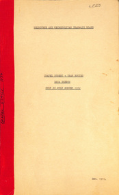
Document - Report, Melbourne & Metropolitan Tramways Board (MMTB), "Chapel Street - Tram Routes - Data Sheets - Stop by Stop survey 1972", Dec. 1972
Report - Foolscap, card covers, red tape binding, 10 pages, titled "Chapel Street - Tram Routes - Data Sheets - Stop by Stop survey 1972" Maps running times and summary including a check across conductors journals. Dated Dec 1972, notes work done by L Hogan, W. TootellHas "Lees" in the top right hand corner and the title on the left side of the report.trams, tramways, routes, passengers, planning, development, chapel st -
 Bendigo Military Museum
Photograph - Personnel and Equipment, Army Survey Regiment, Fortuna, Bendigo. c1979, c1979
This is a set of 23 photographs of cartographic, aero-triangulation and lithographic equipment, and personnel at the Army Survey Regiment, Fortuna, Bendigo circa 1979. Photos .8P to .23P were taken in Lithographic Squadron’s printing, Camera, proofing rooms and external buildings. Cartographic Squadron’s SGT Jim McDonald operated the Editwriter type setting machine, as shown in photo .2P for a couple years in a room on the top floor of Fortuna Villa. This is a set of 23 photographs of cartographic, aero-triangulation and lithographic equipment, and personnel at the Army Survey Regiment, Fortuna, Bendigo, c1979. Black and white photos are on photographic paper and mounted on manilla card. They were scanned at 300 dpi. .1) - Photo, black & white, c1979, Typesetting machine, ‘Editwriter’ Model 7500, SGT Jim McDonald. .2) - Photo, black & white, c1979, Processor Model ACP101 & dual disk module (attached to Editwriter). .3) - Photo, black & white, c1979, Duplicating machine, stencil process electric ‘Gestetner’. .4) - Photo, black & white, c1979, Comparator photogrammetric stecometer, modified ‘Carl Zeiss’, CPL Jack Elverd. .5) - Photo, black & white, c1979, Point transfer device ‘Wild PUG IV. .6) - Photo, black & white, c1979, Zoom transfer scope, stereo ‘Bausch & Lomb’ .7) - Photo, black & white, c1979, Stereoplotter analytical automatic, ‘APC/3-1’. .8) - Photo, black & white, c1979, Prophylaxis unit, ‘Densply/Cavtron’ .9) - Photo, black & white, c1979, Machine punch register (made by Bendigo Ordnance Factory). .10) - Photo, black & white, c1979, Plan printer 122cm (48”) wide. ‘Admel Bruning’ Model - 5003A. .11) - Photo, black & white, c1979, Metal halide printing lamp. ‘Violight 5000 HV’ .12) - Photo, black & white, c1979, Densitometer transmission or reflection, ‘Macbeth’ Model – TR 524 MD. .13) - Photo, black & white, c1979, Machine whirling vertical type ‘Payne VLW’. .14) - Photo, black & white, c1979, Densitometer reflection, ‘Macbeth’ Model – RD917. .15) - Photo, black & white, c1979, Densitometer reflection, 240V ‘Cosar’ .16) - Photo, black & white, c1979, Printer contact ‘Hohlux’ Model RP-II, LCPL Martin Van der Maele. .17) - Photo, black & white, c1979, Frame printing vacuum vertical. .18) - Photo, black & white, c1979, Frame printing vacuum flip top 91cm x 117cm. .19) - Photo, black & white, c1979, Printer reduction stereo plotter diapositive ‘Wild’ Model – U3A modified and U4A modified to U4A plus. .20) - Photo, black & white, c1979, Printing press offset rotary lithographic 3 colour ‘Ultra-MAN-III’ .21) to. 23) - Photo, black & white, c1979, Camera cartographic consolidated super 100 32” x 32”The three personnel appearing in this set are identified. Most items have a full description, NSN, serial number, and the Repairer’s name, address and phone details and contact name. Just the full description is documented.royal australian survey corps, rasvy, army survey regiment, army svy regt, fortuna, asr -
 Bendigo Military Museum
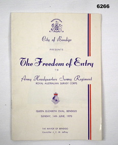
Booklet - City of Greater Bendigo Presents "The Freedom of Entry to Army Headquarters Survey Regiment", Army Headquarters Survey Regiment, 14.06.1970
This booklet is the program for the AHQ Survey Regiment Freedom of Entry to Bendigo on Sunday 14 Jun 1970 held at the Queen Elizabeth Oval, Bendigo. The ceremony was officiated by the Mayor of Bendigo Councillor CM JeffreyBooklet, B4 size, 11 pages, semi gloss paper, cover, red and blue text, contents, photos and text.army survey regiment, army svy regt, fortuna, royal australian survey corps, rasvy, asr -
 Bendigo Military Museum
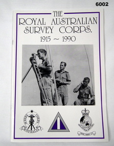
Booklet - Booklet Royal Australian Survey Corps History, " The Royal Australian Survey Corps " 1915-1990, c, 1995
This article was presented as a paper to the 1990 Australian War Memorial History Conference to mark the 75th anniversary of the formation of the "Australian Survey Corps" on 1 July 1915. The Corps has since been renamed. Booklet, A4, 13 Pages, Cardboard Cover, Colour, Maps, Photographs, Black and White. Held together by metal staplesroyal australian survey corps, rasvy, fortuna, army survey regiment, army svy regt, asr -
 Bendigo Military Museum
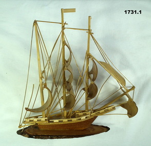
Souvenir - BOAT MODELS, 1962-72
The two models were collected from small village in South Vietnam by Geoff Murray No 3411521, Vietnam 3 Cav Regt 27.11.67 to 22.10.68, Survey Corp 15.10.69 to 15.10.70. Refer 638P..1 Model of a three masted ship made entirely of bamboo, mounted on a slice of timber. .2 Model of a two storey native stilt house with a tree made of a twig and painted polystyrene. Mounted on a slice of timber.handcrafts-sailor's craft, woodwork, vietnam, models -
Tatura Irrigation & Wartime Camps Museum
Book, Soils and Land Use, 1963
Advice to land holders on how to use the Soil Survey Report. Soils and land use in the deakin Irrigation area, Vict, Technical Bulletin No. 16, Melb. Includes maps for Deakin Irrigation AreaCream cover, black writing, Techical Bulletin No. 16soils and land use, tatura, irrigation, books, technical, rural, industry -
 Robin Boyd Foundation
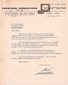
Letter, Hector Crawford, Letter from Hector Crawford to Robin Boyd, 13.08.1963
Letter from Hector Crawford, Managing Director of Crawford Productions, and attached document provides information regarding 1963 radio survey figures (ratings) gauging relative popularity of stations in Australian cities.The Flying Dogtor" series was broadcast on Australian Television Network (later becoming the Seven Network) between February and April 1964 (see item D254 for schedule).Typewritten, quarto, one page letter. Attached document is 7 foolscap, typed pages.radio survey data, radio ratings, the flying dogtor, robin boyd, crawford productions -
 Bendigo Military Museum
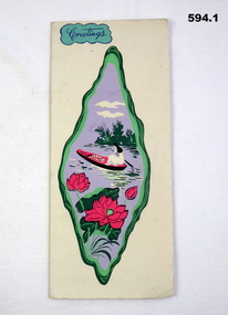
Card - XMAS CARD, C.1969 - 71
Hand written inside. "Murray, I will never forget you, how are you? I hope you are always well! My regards to your mother. I hope to one day see you again in V.Nam. Sister Augustine". The card relates to Geoff Murray No 3411521, 3 Cav Regt Vietnam 27.11.67 to 22.10.68, Survey Corp Vietnam 15.10.69 to 15.10.70. On his 2nd tour with Survey Corp Geoff procured a lot of food etc for the Baria Orphanage. Refer 610.2P, 611.8, 1866.3 re the Orphanage and Sister Augustine also 638P.Christmas card with river scene painted on front. .1) Heavy card outer pages. .2) Fine tissue paper inner pages..1) "Greetings" .2) "Merry Christmas and Best Wishes for a Happy New Year"cards, xmas, vietnam -
 Bendigo Military Museum
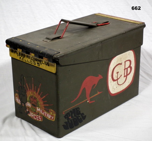
Container - AMMUNITION BOX
Box used by Anthony Robert Cornelius to take beer cans to the movies of a night in 1 ALSG Vietnam. Refer 1874.2 for his service history. Ammunition box, steel, green colour, rectangular shape. Item has been hand painted with various cartoon characters, signs, rising sun, kangaroo, military logos. A carry handle one one end. On the inside is a hand written list re service from Kapooka, Malaya, Vietnam to Army Survey Regiment Bendigo.“3176333 A.R. Cornelius “Kellogg’s”arms- ammunition, containers - commercial -
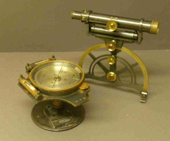 Federation University Historical Collection
Instrument - Miner's Dial, c early 1900s
A miner's dial was used by surveyors to determine the direction of underground tunnels and roadways. The inclinometer allowed measurement of the angles at which mine tunnels descend into the ground.A rare miner's dial in a hinged timber box.This surveying instrument consists of a theodolite monsblr on a magnetic compass, which sits on the vertical tapered spigot of a base plate. Fits tripod catalogued item 4133. Inside the box lid is the supplier's label - W. Travill (successor to D. Esdale) of 146 Little Collins Street, Melbournemining, ballarat school of mines, surverying, scientific instruments, scientific objects -
 Federation University Historical Collection
Booklet, John Fraser, City of Ballarat 1856-1956, 1956
The Ballarat Municipality was established in 1856.Cream covered booklet covering a special meeting held to commemorate the 100th anniversary of the City of Ballarat Council. It includes a notice paper for a special meeting of Council, minutes of the Municipal Council of Ballaarat, first meeting, and images of the first survey of the Ballarat Township (1852), Ballarat in 1854, Central Ballarat in 1956, N. T. Callow and James Oddie. ballarat, council, ballarat east, ballaarat, munipality, ballarat townscape, sturt street, ballarat survey, yarrowee, paroompi, parmoompi, diggings -
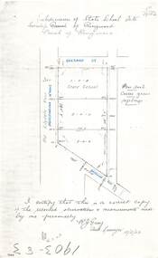 Ringwood and District Historical Society
Document - Copy of Lands Department Field Notes - Subdivision of State School Site, Township of Ringwood, Victoria, Field Notes 1903/83 - Part of O.P. R72C Surveyed 13/2/1903
Foolscap size photocopy of survey map with handwritten notations. References include Everard Street, Old Lilydale Road (Maroondah Highway), Dublin Road, poor soil, coarse grass, saplings, I certify that this is a correct copy of the recorded observations & measurements made by me personally (signed) R.J. Gray Autorised Surveyor 13/2/03. -
 Bendigo Historical Society Inc.
Photograph - BENDIGO POST OFFICE 1854
Photo: copy of photo of first Bendigo Post Office and Survey Office, located corner of Mitchell and Pall Mall. Building constructed by John Pyke, land purchased for 1800 pounds in first land sales. Source of information: Dr. Ralph Birrell. This reproduction is the property of the National Library of Australia, and is not for reproduction in any form apart from for research.bendigo, buildings, post office and survey office -
Bendigo Historical Society Inc.
Map - HEATHCOTE : COUNTY OF BENDIGO, 11-4-35
Map. Heathcote, County of Bendigo, County of Dalhousie,Township of Heathcote, McIvor Creek, Argyle Station Ground, Wallan and Bendigo Railway, C.R.B. Main Road. By authority H.J. Green, Govt. Printer. Photo-Lithographed at the Department of Lands and Survey, Melbourne. 11-4-35. Price 2/-. (number 88 in map cupboard 1)H.J. Green, Govt.Printermap, bendigo, heathcote -
Bendigo Historical Society Inc.
Map - PANNOOBAMAWM : COUNTY OF BENDIGO, 1957
Map. Pannoobamawm, County of Bendigo, Turrumberry, Terrick Terrick East, Wanurp, Pannoomilloo, Bamawm, Elmore to Cohuna Railway, McColl Station Ground, Lockington Station Ground. By authority W.M. Houston, Government Printer, Melbourne. Drawn and reproduced at the Department of Lands and Survey, Melbourne 1957. Price 2/-. (number 80 in map cupboard 1)W.M. Houston, Government Printer, Melbourne.map, bendigo, pannoobamawm -
Bendigo Historical Society Inc.
Map - MARONG : COUNTY OF BENDIGO, 25-6-25
Map. Marong, County of Bendigo, Nerring, Sandhurst, Lockwood, Shelbourne, Woodstock, Leichardt, Kangaroo Flat Rifle Range, Crusoe Aqueduct. By authority H.J. Green, Government Printer, Melbourne. Photo-Lithographed at the Department of Lands and Survey, Melbourne by W.J. Butson 25-6-25.Price 1/-. (number 75 in map cupboard 1)H.J. Green, Government Printer, Melbourne.map, bendigo, marong -
 Bendigo Historical Society Inc.
Document - AULSEBROOK COLLECTION: FUNERAL PAMPHLET, 1970
Aulsebrook Collection: Funeral Pamphlet Title: Funeral of the late Lieutenant Colonel Lionel Bernard Sprenger, MBE, Commanding Officer, Amry Headquarters Survey Regiment, 11th- March 1920 - 5th December 1970 -A5, 2 pages (also folds out but no extra pages of information). -Order of service for the funeral including, songs, tributes and readings. -
Bendigo Historical Society Inc.
Map - CAMPBELL COLLECTION: BENDIGO AND DISTRICT MAPS, 1962
Map. Mandurang, County of Bendigo. Scale 40 chains to 1 inch. Sandhurst, Strathfieldsaye, Sedgwick, Sutton Grange, Ravenswood, Lockwood, Township of Kangaroo Flat, Township of Mandurang. By Authority A.C. Brooks, Government Printer, Melbourne. Drawn and Reproduced at the Department of Lands and Survey, Melbourne,1962, Price 2/-. (number 401 in map cupboard 1)A.C. Brooks, Government Printer.map, bendigo, allotments -
Bendigo Historical Society Inc.
Map - GOORNONG : COUNTY OF BENDIGO, 27-10-25
Map. Goornong, County of Bendigo, Egerton, Nolan, Ellesmere, Bagshot. Town of Goornong, Northern Railway. Campaspe, Muskerry, Campaspe River. Photo-Lithographed at the Department of Lands and Survey, Melbourne by W.J. Butson, 27-10-25,Price 1/-. By authority: H.J. Green, Government Printer, Melbourne. (number 43 in map cupboard 1)H.J. Green,Govt.Printer, Melbourne.map, bendigo, goornong -
Bendigo Historical Society Inc.
Map - SALISBURY WEST : COUNTY OF BENDIGO, 24-6-24
Map. Salisbury, County of Bendigo, County of Gladstone, Powlett, Yarrayne, Bridgewater, Inglewood, Glenalbyn, Kurting, River Loddon, Bulabul Creek. By authority A.J. Mullett, Government Printer, Melbourne. Photo-Lithographed at the Department of Lands and Survey, Melbourne by W.J. Butson, 24-6-24. Price 1/-. (number 116 in map cupboard 1)A.J. Mullett, Government Printer, Melbourne.map, bendigo, salisbury west -
Bendigo Historical Society Inc.
Map - HAWKESTONE : COUNTY OF BENDIGO, 7-11-15
Map. Hawkestone, County of Bendigo, County of Talbot, Lyell, Sutton Grange, Redcastle, Elphinstone, Metcalfe, Coliban River, Myrtle Creek. Albert J. Mullett, Government Printer, Melbourne. Photo-Lithographed at the Department of Lands and Survey, Melbourne by W.J. Butson,7-11-15. Price 1/-. (number 111 in map cupboard 1)Albert J. Mullett, Government Printer, Melbourne.map, bendigo, hawkestone. -
Bendigo Historical Society Inc.
Map - MUSKERRY : COUNTY OF BENDIGO, 1962
Map. Muskerry, County of Bendigo, County of Rodney, Goornong, Ellesmere, Axedale, Weston, Crosbie, Toolleen, Campaspe, Forest or Mannering Creek, Back Creek, Campaspe River. By authority A.C. Brooks, Government Printer, Melbourne. Drawn and reproduced at the Department of Lands and Survey, Melbourne, 1962. Price 2/-. (number 110 in map cupboard 1)A.C. Brooks, Government Printer, Melbourne.map, bendigo, muskerry -
Bendigo Historical Society Inc.
Map - HARCOURT, December 1951
Harcourt, County of Bendigo, Walmer, Castlemaine, Sutton Grange. Mt.Alexander Trig. Station, Barkers Creek, Faraday, Calder Highway, Northern Railway. By Authority J.J.Gourley, Government Printer, Melbourne,Drawn and Reproduced at the Dept. of Lands and Survey, Melbourne, Victoria. December 1951. Price 5/-per sheet. (number 35 in map cupboard 1)J.J.Gourley, Government Printer, Melbourne.map, bendigo, harcourt -
 Villa Alba Museum
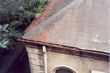
Photograph - Slate roof and guttering, c.1987
Built for William and Anna-Maria Greenlaw in the early 1880s, and with interiors decorated by the Paterson Bros, Villa Alba remained in private ownership until 1949. From 1950, the house was owned by a number of institutions. By 1984, the Villa Alba Preservation Society had been formed, and three years later, the Mount Royal Hospital granted a 25-year lease to Kew Council. In 2004, the title to Villa Alba was passed by the Victorian Government to The Villa Alba Museum Incorporated. The Museum, at 44 Walmer Street, Kew, is now a cultural institution committed to the collection, study and display of 19th century interior decorative finishes, and the components of 19th and 20th century interior decoration.This is one of a number of historically and aesthetically significant photos of the interiors and exterior of Villa Alba when it was still owned by the Mount Royal Hospital, showing twentieth century accretions and deterioration of the historic fabric of the building. This was a benchmark survey against which future conservation and restoration activities can be measured.In December 1987, Mockridge Stahle & Mitchell Pty Ltd Architects prepared ‘Villa Alba Survey: A Report on the fabric for Mount Royal Hospital’ of which this photograph is a part. Photo of one corner of the slate roof with evidence of slipped slates, rusted and blocked galvanised guttering and encroaching trees. This section of the roof is in the north west corner of the house.villa alba museum, conservation photographs, victorian architecture, slate roofs, gutters -
 Bendigo Historical Society Inc.
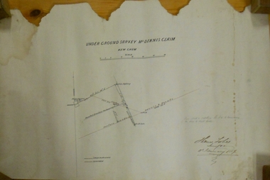
Plan - MARKS COLLECTION: UNDERGROUND SURVEY MR. DENNIS CLAIM NEW CHUM
Plan on heavy parchment paper. On top of plan 'underground survey Mr. Dennis, New Chum' Signed: Thomas Forbes, Surveyor, 11th. January 1867. shows surface boundary of Dennis and Bonati. Written in blue pencil 'From nail in sapling 33f. 51/2 to boundary. Online to drill hole' Shaft marked on LH boundary.'bendigo, mining, mr. dennis claim, new chum -
 Bendigo Historical Society Inc.
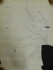
Document - MARKS COLLECTION: PLAN OF SANDHURST CITY CENTRE AND SURROUNDING AREA ( NO. 2 )
Plan drawn on heavy parchment. Written on plan Sandhurst Sheet No. 2. (See record 8300.58 for continuation of plan into city centre) Plan shows allotments with owner names, where applicable. Quartz crushing machines marked. On bottom lithographed at the Department of Lands and Survey, Melbourne, by D. Henerson, March 12th., 1867. There is also a photocopy.bendigo, planning, sandhurst -
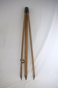 Kiewa Valley Historical Society
Tripod
This tripod was used to measure the height of distant points relative to a known point used in surveying and construction. The older levels consist of a telescope fitted with a spirit level and, generally, mounted on a tripod. Modern levels are automatic.This tripod was used in the Kiewa Valley by a Mt Beauty resident.Wooden tripod with pointy ends and with metal hinges at the top to collapse. It has a leather strap attached by a button press stud towards the pointy end. This is to enable the legs of the tripod to be fastened together. cowley tripod; surveying; kiewa valley; -
 Port Melbourne Historical & Preservation Society
Photograph - J Kitchen & Sons perimeter survey, Williamstown Road and Normanby Road, Dec 2013
As the former j Kitchen & Sons site was being cleared, Lionel Layfield, who had worked at the site for many years undertook several pictorial perimeter surveys. These photos were taken in Dec 2013.Series 1 of colour photographs taken by Lionel Layfield as he walked around the perimeter of the J Kitchen & Sons Pty Ltd factory site during the early demolition of most of the buildings. .01-.08 - corner of Williamstown Road and Normanby Road to Ingles Streetindustry - manufacturing, built environment - industrial, business and traders - soaps/candles, demolitions, j kitchen & sons pty ltd, symex holdings ltd, north port oval, port melbourne cricket and football oval -
 Port Melbourne Historical & Preservation Society
Photograph - J Kitchen & Sons perimeter survey, Munro Street, Dec 2013
As the former j Kitchen & Sons site was being cleared, Lionel Layfield, who had worked at the site for many years undertook several pictorial perimeter surveys. These photos were taken in Dec 2013.Series 1 of colour photographs taken by Lionel Layfield as he walked around the perimeter of the J Kitchen & Sons Pty Ltd factory site during the early demolition of most of the buildings. .09-.15 - from Munro St entrance by the weighbridgeindustry - manufacturing, built environment - industrial, business and traders - soaps/candles, demolitions, j kitchen & sons pty ltd, symex holdings ltd, north port oval, port melbourne cricket and football oval