Showing 2910 items matching "australian maps"
-
 Whitehorse Historical Society Inc.
Map, State Savings Bank of Victoria, 1921
Map of Box Hill, Blackburn and Tunstall, 1921 from Australian Guide and Business Directory showing site of Box Hill branch of State Savings Bank of Victoria.Map of Box Hill, Blackburn and Tunstall, 1921 from Australian Guide and Business Directory showing site of Box Hill branch of State Savings Bank of Victoria.Map of Box Hill, Blackburn and Tunstall, 1921 from Australian Guide and Business Directory showing site of Box Hill branch of State Savings Bank of Victoria.maps, box hill, blackburn, state savings bank of victoria -
Whitehorse Historical Society Inc.
Document - Report, Henry William Dowton, 1/06/1997
Luther College Year 10 History report on Henry William Dowton, a name on the Mitcham War Memorial. Includes material from Australian Archives and from the family. 'Dick' Dowton was from Gippsland and was killed at Pozieres during the Battle of the Somme on 25th July 1916. The report details visits to various War Memorials and the search for information. Also included is information from the Trafalgar Historical Society including correspondence to and from Dowton and between his parents and the army as they sought information about his death. Illustrations, maps, 64 pages.dowton, henry william;, world war, 1914-1918. battle of the somme, war memorials -
Whitehorse Historical Society Inc.
Map, Deakin, 1977
... electoral division) australia. parliament Map of the Commonwealth ...Map of the Commonwealth Electoral Division of Deakin. Scale 1: 25,000.Map of the Commonwealth Electoral Division of Deakin. Scale 1: 25,000.Map of the Commonwealth Electoral Division of Deakin. Scale 1: 25,000.electoral boundaries, deakin (commonwealth electoral division), australia. parliament -
 Whitehorse Historical Society Inc.
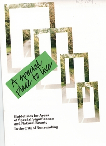
Pamphlet, A Special place to live, 1985 (addendum 1988)
A publication of the City of NunawadingA publication of the City of Nunawading explaining the regulations applying to the Special Residential (Nunawading) Zone No 5. The regulations cover proportions of land which may be built on and identifies trees which must be preserved. An addendum issued in 1988 includes a map of the area and identifies National Trust classified streets in Blackburn and the buffer areas in which less stringent regulations apply.A publication of the City of Nunawadingcity of nunawading, national trust of australia (victoria), special residential (nunawading) zone no. 5, jeffery street, blackburn, laurel grove, linum street, boongarry avenue, hill street, land use, by-laws, town planning, acacia avenue, waratah crescent -
Whitehorse Historical Society Inc.
Legal record - Land Title, Musk Street, Blackburn
Land Titles referring to No. 1 Musk Street, BlackburnLand Titles referring to No. 1 Musk Street, Blackburn : 1. Vol. 542 Fol. 108222, James William Barnes, 1872; 2. Vol. 1877, Fol. 375367, Freehold Investment and Banking Company of Australia Limited, 1886; 3. Transfer 1507851 to John Thomas Williams, 1932; 4. Vol. 8109 Fol. 997 William Henry Rogers, 1955, with Plan of Subdivision CP 21670; 5. cadastral map, AMA zone 55, Sep 2000.Land Titles referring to No. 1 Musk Street, Blackburn musk street, blackburn, no. 1, maple street, blackburn, lawson street, blackburn, elder street, blackburn, barnes, james william, freehold investment and banking company of australia ltd, springfield road, blackburn, whitehorse road, blackburn, barnes estate -
Whitehorse Historical Society Inc.
Document, Australian Social History House Research Assignment, 1986
... Estate Brochures, Maps, Photos, Floor Plans. Morton Thomas ...Social History of 2 Gordon Crescent, Blackburn,Social History of 2 Gordon Crescent, Blackburn, included - History of Blackburn, Architecture of the House and first owner, Thomas Richards Burrowes. Morton. Real Estate Brochures, Maps, Photos, Floor Plans.Social History of 2 Gordon Crescent, Blackburn, morton thomas richards burrowes, architecture -
Whitehorse Historical Society Inc.
Article, Art in bark, 2012
The Art in Bark state branch has displayed their mural of a map of the State of Victoria in eight panels.The Art in Bark state branch has displayed their mural of a map of the State of Victoria in eight panels. Col. photoThe Art in Bark state branch has displayed their mural of a map of the State of Victoria in eight panels. bark murals, art in bark association of australia, koonung cottage community house, gibson, robyn -
 Whitehorse Historical Society Inc.
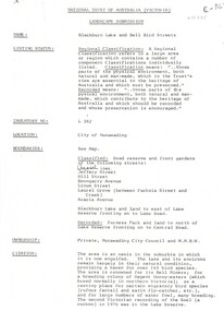
Document, Landscape Submission, c 1976
A landscape submission written for the National Trust of Australia (Victoria) for Blackburn Lake and the Bell Bird Streets.A landscape submission written for the National Trust of Australia (Victoria) for Blackburn Lake and the Bell Bird Streets. Definitions given of boundaries of the Lake area, ownership, housing and gardens. Photographs and map.A landscape submission written for the National Trust of Australia (Victoria) for Blackburn Lake and the Bell Bird Streets.blackburn lake sanctuary, waratah crescent, blackburn, jeffery street, hill street, boongarry avenue, linum street, laurel grove, acacia avenue, city of nunawading, melbourne and metropolitan board of works, furness park, camberwell grammar school -
Whitehorse Historical Society Inc.
Document, Mitcham before 1940s, 1970s?
Four pages of sketch maps of Mitcham business areas.Four pages of sketch maps of Mitcham business areas. Includes: brief history of three hotels; Timeline of development 1851-1971; Details from 1924 Census re local traffic; Details from 1854 Census re populationnon-fictionFour pages of sketch maps of Mitcham business areas. hill hotel, mitcham, mitcham hotel, australia. census 1854, census 1924, traffic, mitcham road mitcham, station street mitcham, britannia street mitcham, whitehorse road mitcham, harvest home hotel -
Whitehorse Historical Society Inc.
Map, Ringwood, 1935
... -Cockatoo, Lilydale-Dandenong Maps Ringwood Australia Ringwood ...Australia Ringwood and area map.Australia1:63,360 series map, Ringwood N.849 Zone 7. Scale 1 inch to 1 mile. Approximate scope: Prahran-Cockatoo, Lilydale-DandenongAustralia Ringwood and area map.maps, ringwood -
Whitehorse Historical Society Inc.
Book, The Herald Road Guide, 1930's
... Mitcham melbourne Owner's signature inside cover C.A.Houston Maps ...A Road Guide Book of Victoria and routes to Sydney, Brisbane, Canberra, Adelaide and Alice Springs.A Road Guide Book of Victoria and routes to Sydney, Brisbane, Canberra, Adelaide and Alice Springs.A Road Guide Book of Victoria and routes to Sydney, Brisbane, Canberra, Adelaide and Alice Springs.maps, tourism, australia, victoria -
 Whitehorse Historical Society Inc.
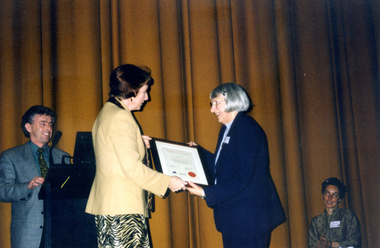
Photograph, Museum Accreditation Ceremony, 1/05/2000 12:00:00 AM
... of Museum Accredit ion Program (MAP) of Museums Australia Victoria... Mitcham melbourne museums australia (vic) museum accreditation ...Coloured photo of president of Nunawading and District Historical Society, Valda Arrowsmith, receiving Accreditation Certificate from Minister for the Arts, Mary Delahunty on behalf of Museum Accredit ion Program (MAP) of Museums Australia Victoria at the Capitol Theatre melbourne.museums australia (vic) museum accreditation program, nunawading and district historical society, schwerkolt cottage and museum complex, arrowsmith, valda, delahunty, mary, victoria. ministry of the arts -
 Whitehorse Historical Society Inc.
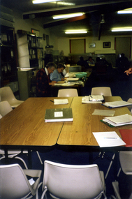
Photograph, Map Visit, 1/11/1999
Coloured photo of Map Representatives on Museum's Accreditation Inspection Visit, L-R - Jude Fraser, Barbara Gardiner (NDHS Secretary), Matthew Churchward, Elizabeth Triarico.schwerkolt cottage and museum complex, museums australia (vic). museum accreditation program, fraser, jude, gardiner, barbara, churchward, matthew, triarico, elizabeth -
 Whitehorse Historical Society Inc.
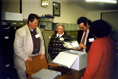
Photograph, Map Visit, 1/11/1999
Coloured photo of Society Volunteers working on cataloguing Artefacts on the occasion of Museum Accreditation Programme Reps visit for Inspection.museums australia (victoria). museum accreditation programme, schwerkolt cottage and museum complex -
 Whitehorse Historical Society Inc.
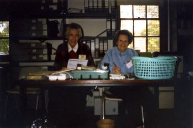
Photograph, Map Visit, 1/11/1999 12:00:00 AM
Coloured photo of Society Volunteers, Frances Warren and Margaret Skey working cataloguing Artefacts on the occasion of Museum Accreditation Inspection Visit.warren, frances, skey, margaret, museums australia (vic). museum accreditation program, schwerkolt cottage and museum complex -
 Whitehorse Historical Society Inc.
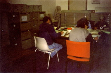
Photograph, Map Visit, 1/11/1999 12:00:00 AM
Coloured photo of Society Volunteers cataloguing Paper Collection on the occasion of Museum Accreditation Programme Inspection Visit.simmenauer, peter, crick, joan, museums australia (vic). museum accreditation program schwerkolt cottage and museum complex -
Whitehorse Historical Society Inc.
Map, Archaeological Sites, 1984
Australian Mutual Provident Society Calendar 1984. Includes table of types of sites associated with aboriginals of Victoria.Australian Mutual Provident Society Calendar 1984. Includes table of types of sites associated with aboriginals of Victoria.Australian Mutual Provident Society Calendar 1984. Includes table of types of sites associated with aboriginals of Victoria.aborigines, australian mutual provident society, archaeology -
 Whitehorse Historical Society Inc.
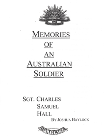
Photograph - School Project, Memories of an Australian Soldier, 1/06/1997 12:00:00 AM
Photocopy of Luther College Year 10 history project describing several war memorials and researching the story of Sergeant Charles Samuel Hall whose name appears on the Mitcham War Memorial. He served at Gallipoli and on the Western Front but contracted tuberculosis and died at the Australian Military Hospital, Harefield Park in Middlesex. The report includes information about tuberculosis and relates the disease to the conditions in Gallipoli and in France. A report on the Battle of Pozieres is included. 70p. Maps. Photographs.hall, charles samuel, world war 1914-1918. battle of poziers, war memorials -
 Whitehorse Historical Society Inc.
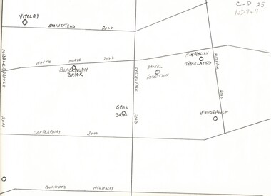
Map, Potteries, n.d
... tile co. pty ltd. daniel robertson australia pty ltd Sketch map ...Sketch map of location of potteries in the area bounded by Middleborough, Springfield, Mitcham Roads and Burwood Highway.Sketch map of location of potteries in the area bounded by Middleborough, Springfield, Mitcham Roads and Burwood Highway.Sketch map of location of potteries in the area bounded by Middleborough, Springfield, Mitcham Roads and Burwood Highway.potteries, vitclay pipes pty ltd, blackburn brick and tile co., geal bros., wunderlich limited, australian tesselated tile co. pty ltd., daniel robertson australia pty ltd -
 Highett RSL Sub Branch Inc
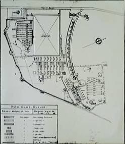
Map, Changi POW camp, C 1950s
Changi POW camp SingaporeAustralian POWs Copy of originalSigned Frank Holland-Stabbacksecond world war -
 Unions Ballarat
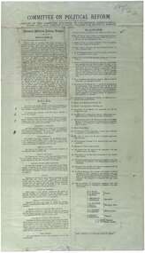
Printed report of the Committee appointed by the Congress to draft a scheme for political reform - the National Political Reform League, 1891
Political reform was high on the agenda of Australian Congress Committees. The report includes the preamble, rules and platform. Ballarat was chosen as the venue for the important 7th Intercolonial Trade Union Congress of Australia in April 1891 at which certain resolutions concerning political action by the workers were passed. The 7th Intercolonial Trades Union Congress in Ballarat is considered to be the beginnings of the Victorian Labor Party and mapped out 'One Big Union' which ultimately led to the formation of the ACTU.Relates to the history of the BTLC, political reform and other Australian Congress Committees - see 0019-26.Paperballarat trades hall, ballarat trades and labour council, political reform, australian congress committees, btlc, national political reform league, 7th intercolonial trades union congress, labor party - victoria, alp, one big union, actu -
Ballarat Heritage Services
Booklet, Rev. C.G. Schmidt, The Lutheran Church in Castlemaine also Yandoit and Maldon, c1986
... pastor munzel pastor leypoldt german australians map ...Eighteen page booklet on the Lutheran church in and around Castlemaine. castlemaine, yandoit, maldon, lutheran church, pastor munzel, pastor leypoldt, german australians, map of castlemaine -
 Dandenong/Cranbourne RSL Sub Branch
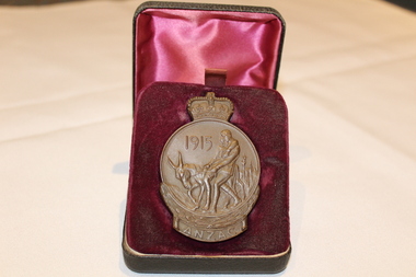
Medal - Medallion with original cardboard box, Unknown
... at the back. Map of Australia and New Zealand with the stars.... Simpson and his Donkey embossed at the back. Map of Australia ...WWI historic history.Bronze medallion presented to 2061 William Henry Elliott. Medallion is in commemoration of the men of ANZAC at GALLIPOLI in 1915 and in recognition of the great debt owed by all Australians. With the compliments of the Government of Australia. Medallion is round with a crown at the top.Cardboard box has typed address to Mrs L. Elliott, 59 Cleeland St, Dandenong from Central Army Records Office.W.H. Elliott. 1915 ANZAC. Simpson and his Donkey embossed at the back. Map of Australia and New Zealand with the stars of the Southern Cross embossed on the front. -
 Dandenong/Cranbourne RSL Sub Branch
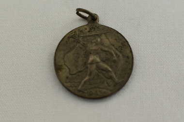
Medal - ANZAC 1915 Medalion, Unknown
... 1915, ANZAC on one side with a map of Australia and New... side with a map of Australia and New Zealand with the Southern ...WWI Historical significanceANZAC medallion with crown on top and Simpson and his donkey engraved on the medalion1915, ANZAC on one side with a map of Australia and New Zealand with the Southern Cross engraved on the other. The name E. Bourke is engraved on the bottom. -
 Dandenong/Cranbourne RSL Sub Branch
Medal - Victory Medal 1945
Circular Medal with suspension loop. The front of the medal shows a Knight with sword in front of an outline of Australia &1945, The back shows a map of the southern hemisphere showing Australia, Antarctica, New Zealand, South America & South Africa. At the top has words Victory Medal and the bottom manufacturers marking,Victory Medal 1945 -
 Dandenong/Cranbourne RSL Sub Branch
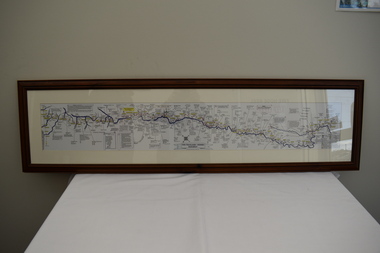
Map - Burma - Siam Railway
Is of Historical significance. This map was put together by T.R.Beaton on the 15th February 2002. He used old railway and road maps to show the route and it took him over 15 months to put together. T.R. Beaton was Manager/Curator of Australian Government Memorial Museum built above " Hellfire Pass " or Konyu Cutting.Framed picture map of the Burma _ Siam Railway. -
 Dandenong/Cranbourne RSL Sub Branch
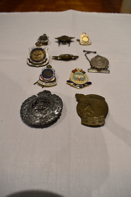
Badge - 10 assorted badges
... by Laurel Leaves with Map of Australia in centre. Returned From... To The Women of Australia Crown surrounded by Laurel Leaves with Map ...Various Historical significance.Australian returned from active service badges. 2 x Returned Soldiers and Sailors Imperial League Badges. (1919 - 1947.) 2 x 1971 to 1990 Life Member Badges. Maralinga & Monte Bello Association Badge. Boomerang with Rising Sun badge. Royal Australian Engineers 1930 - 1942 badge. Silver badge "To the Women of Australia. Vintage Turkish Medal. Inscribed To The Women of Australia Crown surrounded by Laurel Leaves with Map of Australia in centre. Returned From Active Service. Two or Three Servicemen shown. RAAF #A1102 - 1942. Boomerang with Rising Sun below Crown. Royal Engineers Badge inscribed "FACIMUS ET FRANCIMUS" encircling GviR in centre Crown over Laurel leaves. -
 Ballarat Heritage Services
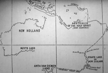
Photograph - Map, A Sketch from Dalyrmples Map of 1767, 1767
Copy of a map showing the coast that was known during the voyge of the Endeavour, and the first map that marks Torres track.map, new holland, hollandia nova, isaac de graaff, new guinea, australia of the holy spirit, papua, new hebrides, new zealand, nuyts land, van dieman's land, tasman's track, torres -
 Ballarat Heritage Services
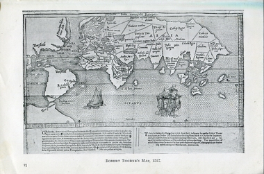
Photograph - Map, Robert Thorne's Map, 1527, 1527
... near Australia. map robert thorne robert thorne's map spanish ...This map serves the purpose of proving that Thorne and the Spanish geographers knew nothing about a continent near Australia.Copy of a map from 'A Short HIstory of Australia' by Ernest Scott.map, robert thorne, robert thorne's map, spanish explorers -
 Ballarat Heritage Services
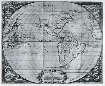
Map, Map Published at Paris, 1587, 1527
... new guinea early australian mapping Copy of a map from ...This map shows a portion of New Guinea, but the plae occupied by Austrlai was left as open ocean.Copy of a map from 'A Short HIstory of Australia' by Ernest Scott.map, paris map, new guinea, early australian mapping