Showing 5898 items
matching 22
-
 Eltham District Historical Society Inc
Photograph, Upper Yarra Dam, Spring Tour, 22 Oct 1995, 22/10/1995
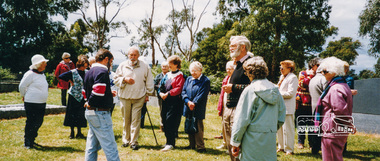
EXPLORING THE UPPER YARRA (Newsletter No. 105, November 1995, by Bettina Woodburn) We enjoyed the Spring Excursion, this year "Exploring the Upper Yarra" - in spite of the constant rain and the countryside under the cloud cover, especially in the valleys, being mainly shiny shades of green. The occasional fields of buttercups, clumps of arum lilies and splendid rhododendron and other flowering bushes became very special. The Cobb and Co coach was warm and a cosy retreat as we zig-zagged on the highways and byways to glimpse the Yarra River, upstream and down, its secret places, and particularly the many bridges. Russell excelled as 'Poet Laureate', reading from Dacre Smyth's book. This 1979 publication includes paintings of all the bridges along the river with poems and brief descriptions of each one. Some of the bridges are in out of the way places and are not very well known. We looked forward to hearing the poetry as much as seeing the ' constructions'…Big Pat (was he short or tall, lean or fat? He did win the two hundred pound reward for discovering gold and had the creek named after him), about the 'Eddies'?, and the disliked 'meccano' bridge in Warburton, etc. etc. The hot roast lunch in the old Reefton Hotel was also most welcome. It was easy to imagine it peopled by miners and early settlers. Starting by crossing the new (1974) concrete bridge at Warrandyte we headed through Wonga Park with views to the Christmas Hills and to the escarpment of the Yering Gorge, which causes flood waters to back up through the Yarra Glen plain, so avoiding disasters downstream. At the end of a long driveway we found the wooden, privately owned Henley Bridge (1935 after the 1934 floods). This facilitates access to different parts of Henley Farm and to Lilydale. Everard Park, named after Blanche Shallard's father, a State Member for 17 years, below the Highway Yarra crossing was in need of care. It is 10 miles from Yarra Glen by road but, as "Yarra Marra” canoeists well know, 32 winding miles down by water. After more delightful countryside scenes we joined the Warburton Highway at Woori Yallock. From the old Railway Station at Launching Place the Centennial Trail for walkers, cyclists and ' horse riders has replaced the rails. The line from Lilydale was opened in 1901, and the last diesel freight train ran to Warburton in 1965. It continued to rain as we had morning tea in Warburton in a shelter between footbridges. From here we continued upstream past the Bridge to O'Shannasy Lodge and Reservoir, Starvation Creek, and the Peninsular tunnel (miners dug it as at Pound Bend) which we visited (scrambling down those steps!) on our return after lunch. Our furthermost point was the Upper Yarra Dam Reserve (and vast catchment area). Finished in 1957 after ten years work and 100 years after Yan Yean, it supplies much of Melbourne's water. After crossing the 30m Launching Place Bridge to the Eltham side of the Yarra and Healesville, we saw in the distance the Yarra Glen Timber Trestle Bridge over the river flats "the longest for years in the land it was said!" Harry's dream of "better weather over the Divide" unfortunately didn't come true, but I'm sure we 36 members will retain happy memories of a day that was wet and green and filled with Bridges. Bettina Woodburn - October 1995 Record of the Society's history of activities - Spring 1995 excursionRoll of 35mm colour negative film, 4 of 5 stripsKodak Gold 400-5shire of eltham historical society, activities, upper yarra dam, henley bridge -
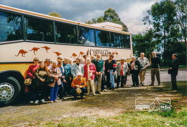
 Eltham District Historical Society Inc
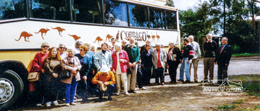
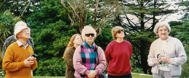
Photograph, Cobb and Co Bus tour, 22 Oct 1996, 22/10/1996
Colour photograph1996, activities, cobb and co -
 Eltham District Historical Society Inc
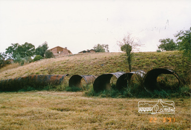
Photograph, Pipes used for original aqueduct crossing of Diamond Creek, Allendale Road, Eltham, 22 March 1991, 22/03/1991
Colour photographmaroondah aqueduct, allendale road -
 Eltham District Historical Society Inc
Photograph, Churchill Island, Spring Excursion, 22 November 1987, 22/11/1987
Churchill Island is a small island adjacent to Philip Island. It is the site where James Grant planted the first crops in Victoria in 1801. It also contains other features of historical and environmental interest.Six colour photographsactivities, churchill island -
 Eltham District Historical Society Inc
Photograph, Henley Bridge, Spring Excursion, Exploring the Upper Yarra, 22 October 1995, 22/10/1995
[article by Bettina Woodburn in EDHS Newsletter No. 105, November 1995:] EXPLORING THE UPPER YARRA - We enjoyed the Spring Excursion, this year "Exploring the Upper Yarra" - in spite of the constant rain and the countryside under the cloud cover, especially in the valleys, being mainly shiny shades of green. The occasional fields of buttercups, clumps of arum lilies and splendid rhododendron and other flowering bushes became very special. The Cobb and Co coach was warm and a cosy retreat as we zig-zagged on the highways and byways to glimpse the Yarra River, upstream and down, its secret places, and particularly the many bridges. Russell excelled as 'Poet Laureate', reading from Dacre Smyth's book. This 1979 publication includes paintings of all the bridges along the river with poems and brief descriptions of each one. Some of the bridges are in out-of-the-way places and are not very well known. We looked forward to hearing the poetry as much as seeing the 'constructions'… Big Pat (was he short or tall, lean or fat? - he did win the £200 reward for discovering gold and had the creek named after him), about the 'Eddies'?, and the disliked 'meccano' bridge in Warburton, etc. etc. The hot roast lunch in the old Reefton Hotel was also most welcome. It was easy to imagine it peopled by miners and early settlers. Starting by crossing the new (1974) concrete bridge at Warrandyte we headed through Wonga Park with views to the Christmas Hills and to the escarpment of the Yering Gorge, which causes flood waters to back up through the Yarra Glen plain, so avoiding disasters downstream. At the end of a long driveway we found the wooden, privately owned Henley Bridge (1935 after the 1934 floods). This facilitates access to different parts of Henley Farm and to Lilydale. Everard Park, named after Blanche Shallard's father, a State Member for 17 years, below the Highway Yarra crossing was in need of care. It is 10 miles from Yarra Glen by road but, as "Yarra Marra” canoeists well know, 32 winding miles down by water. After more delightful countryside scenes we joined the Warburton Highway at Woori Yallock. From the old Railway Station at Launching Place the Centennial Trail for walkers, cyclists and horse riders has replaced the rails. The line from Lilydale was opened in 1901, and the last diesel freight train ran to Warburton in 1965. It continued to rain as we had morning tea in Warburton in a shelter between footbridges. From here we continued upstream past the Bridge to O'Shannassy Lodge and Reservoir, Starvation Creek, and the Peninsular tunnel (miners dug it as at Pound Bend) which we visited (scrambling down those steps!) on our return after lunch. Our furthermost point was the Upper Yarra Dam Reserve (and vast catchment area). Finished in 1957 after ten years' work and 100 years after Yan Yean, it supplies much of Melbourne's water. After crossing the 30m Launching Place Bridge to the Eltham side of the Yarra and Healesville, we saw in the distance the Yarra Glen Timber Trestle Bridge over the river flats "the longest for years in the land it was said!" Harry's dream of "better weather over the Divide" unfortunately didn't come true, but I'm sure we 36 members will retain happy memories of a day that was wet and green and filled with Bridges. Situated on the Yarra River, 5.5 kms south of Christmas Hills on private property. This timber trestle bridge is said to have been built some time after 1907 by Melbourne master-builder, David Mitchell (the father of Dame Nellie Melba), to connect his two "Henley Farm" properties with Lilydale. In earlier days, when the McPhersons owned the property, their children used a punt to cross the river to attend Yering Primary School. This private bridge is best viewed from the end of Wendy Way. - Source: Christmas Hills Past and Present, Yarra Glen & District Historical Society, 2004.Two colour photographsactivities, henley bridge, upper yarra -
 Eltham District Historical Society Inc
Photograph, Spring Excursion, Exploring the Upper Yarra, 22 October 1995, 22/10/1995
[article by Bettina Woodburn in EDHS Newsletter No. 105, November 1995:] EXPLORING THE UPPER YARRA - We enjoyed the Spring Excursion, this year "Exploring the Upper Yarra" - in spite of the constant rain and the countryside under the cloud cover, especially in the valleys, being mainly shiny shades of green. The occasional fields of buttercups, clumps of arum lilies and splendid rhododendron and other flowering bushes became very special. The Cobb and Co coach was warm and a cosy retreat as we zig-zagged on the highways and byways to glimpse the Yarra River, upstream and down, its secret places, and particularly the many bridges. Russell excelled as 'Poet Laureate', reading from Dacre Smyth's book. This 1979 publication includes paintings of all the bridges along the river with poems and brief descriptions of each one. Some of the bridges are in out-of-the-way places and are not very well known. We looked forward to hearing the poetry as much as seeing the 'constructions'… Big Pat (was he short or tall, lean or fat? - he did win the £200 reward for discovering gold and had the creek named after him), about the 'Eddies'?, and the disliked 'meccano' bridge in Warburton, etc. etc. The hot roast lunch in the old Reefton Hotel was also most welcome. It was easy to imagine it peopled by miners and early settlers. Starting by crossing the new (1974) concrete bridge at Warrandyte we headed through Wonga Park with views to the Christmas Hills and to the escarpment of the Yering Gorge, which causes flood waters to back up through the Yarra Glen plain, so avoiding disasters downstream. At the end of a long driveway we found the wooden, privately owned Henley Bridge (1935 after the 1934 floods). This facilitates access to different parts of Henley Farm and to Lilydale. Everard Park, named after Blanche Shallard's father, a State Member for 17 years, below the Highway Yarra crossing was in need of care. It is 10 miles from Yarra Glen by road but, as "Yarra Marra” canoeists well know, 32 winding miles down by water. After more delightful countryside scenes we joined the Warburton Highway at Woori Yallock. From the old Railway Station at Launching Place the Centennial Trail for walkers, cyclists and horse riders has replaced the rails. The line from Lilydale was opened in 1901, and the last diesel freight train ran to Warburton in 1965. It continued to rain as we had morning tea in Warburton in a shelter between footbridges. From here we continued upstream past the Bridge to O'Shannassy Lodge and Reservoir, Starvation Creek, and the Peninsular tunnel (miners dug it as at Pound Bend) which we visited (scrambling down those steps!) on our return after lunch. Our furthermost point was the Upper Yarra Dam Reserve (and vast catchment area). Finished in 1957 after ten years' work and 100 years after Yan Yean, it supplies much of Melbourne's water. After crossing the 30m Launching Place Bridge to the Eltham side of the Yarra and Healesville, we saw in the distance the Yarra Glen Timber Trestle Bridge over the river flats "the longest for years in the land it was said!" Harry's dream of "better weather over the Divide" unfortunately didn't come true, but I'm sure we 36 members will retain happy memories of a day that was wet and green and filled with Bridges.Two colour photographsactivities, upper yarra, upper yarra dam -
 Eltham District Historical Society Inc
Photograph, Yarra River from Henley Bridge, Kangaroo Ground, Spring Excursion, Exploring the Upper Yarra, 22 October 1995, 22/10/1995
[article by Bettina Woodburn in EDHS Newsletter No. 105, November 1995:] EXPLORING THE UPPER YARRA - We enjoyed the Spring Excursion, this year "Exploring the Upper Yarra" - in spite of the constant rain and the countryside under the cloud cover, especially in the valleys, being mainly shiny shades of green. The occasional fields of buttercups, clumps of arum lilies and splendid rhododendron and other flowering bushes became very special. The Cobb and Co coach was warm and a cosy retreat as we zig-zagged on the highways and byways to glimpse the Yarra River, upstream and down, its secret places, and particularly the many bridges. Russell excelled as 'Poet Laureate', reading from Dacre Smyth's book. This 1979 publication includes paintings of all the bridges along the river with poems and brief descriptions of each one. Some of the bridges are in out-of-the-way places and are not very well known. We looked forward to hearing the poetry as much as seeing the 'constructions'… Big Pat (was he short or tall, lean or fat? - he did win the £200 reward for discovering gold and had the creek named after him), about the 'Eddies'?, and the disliked 'meccano' bridge in Warburton, etc. etc. The hot roast lunch in the old Reefton Hotel was also most welcome. It was easy to imagine it peopled by miners and early settlers. Starting by crossing the new (1974) concrete bridge at Warrandyte we headed through Wonga Park with views to the Christmas Hills and to the escarpment of the Yering Gorge, which causes flood waters to back up through the Yarra Glen plain, so avoiding disasters downstream. At the end of a long driveway we found the wooden, privately owned Henley Bridge (1935 after the 1934 floods). This facilitates access to different parts of Henley Farm and to Lilydale. Everard Park, named after Blanche Shallard's father, a State Member for 17 years, below the Highway Yarra crossing was in need of care. It is 10 miles from Yarra Glen by road but, as "Yarra Marra” canoeists well know, 32 winding miles down by water. After more delightful countryside scenes we joined the Warburton Highway at Woori Yallock. From the old Railway Station at Launching Place the Centennial Trail for walkers, cyclists and horse riders has replaced the rails. The line from Lilydale was opened in 1901, and the last diesel freight train ran to Warburton in 1965. It continued to rain as we had morning tea in Warburton in a shelter between footbridges. From here we continued upstream past the Bridge to O'Shannassy Lodge and Reservoir, Starvation Creek, and the Peninsular tunnel (miners dug it as at Pound Bend) which we visited (scrambling down those steps!) on our return after lunch. Our furthermost point was the Upper Yarra Dam Reserve (and vast catchment area). Finished in 1957 after ten years' work and 100 years after Yan Yean, it supplies much of Melbourne's water. After crossing the 30m Launching Place Bridge to the Eltham side of the Yarra and Healesville, we saw in the distance the Yarra Glen Timber Trestle Bridge over the river flats "the longest for years in the land it was said!" Harry's dream of "better weather over the Divide" unfortunately didn't come true, but I'm sure we 36 members will retain happy memories of a day that was wet and green and filled with Bridges.Colour photographactivities, upper yarra, henley bridge -
 Eltham District Historical Society Inc
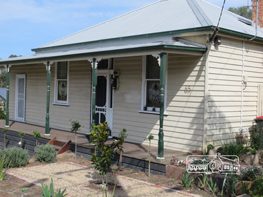
Photograph, Liz Pidgeon, 65 Bible Street, Eltham, 22 September 2017, 22/9/2017
Born Digitalbible street, houses, streets, eltham -
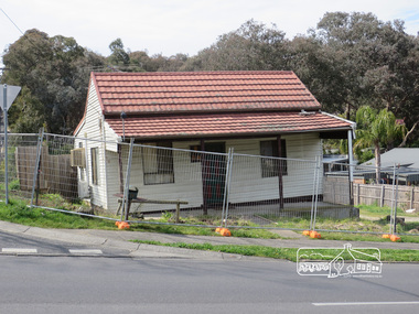 Eltham District Historical Society Inc
Photograph, Liz Pidgeon, 68 Bible Street, Eltham, 22 September 2017, 22/9/2017
At the corner with York Street. Originally built c.1880 but modified later, the house was bulldozed on 19-20 October 2017Born Digitalbible street, houses, streets, eltham -
 Ringwood and District Historical Society
Document - Report, Joy Czarnecki, Ringwood Technical School Report on Planning Effective Inservice Education by Joy Czarnecki Oct 22 1984, 22/10/1984
Black and White Documentrts, ringwood tech -
 Eltham District Historical Society Inc
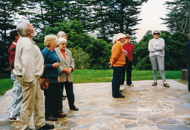
Photograph, Cobb and Co Bus tour, Heritage Excursion, 22 Oct 1996, 22/10/1996
Colour photographactivities, 1996, cobb and co -
 Eltham District Historical Society Inc
Photograph, Kangaroo Ground Cemetery, Heritage Excursion, 22 October 1996, 22/10/1996
Colour photographactivities, heritage excursion, kangaroo ground, kangaroo ground cemetery -
 Eltham District Historical Society Inc
Photograph, Kangaroo Ground Tower, Heritage Excursion, 22 October 1996, 22/10/1996
L-R: Mick and Margaret Woiwod, Keith Banks, Doug OrfordColour photographactivities, heritage excursion, kangaroo ground, keith banks, margaret woiwod, mick woiwod, war memorial tower, doug orford -
 Eltham District Historical Society Inc
Photograph, Kangaroo Ground Tower, Heritage Excursion, 22 October 1996, 22/10/1996
Colour photographactivities, heritage excursion, kangaroo ground, war memorial tower, doug orford -
 Eltham District Historical Society Inc
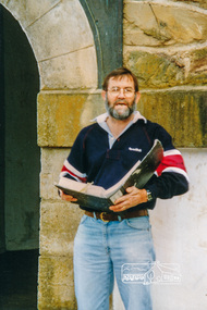
Photograph, Russell Yeoman reading from his notes at the tower entrance, forecourt apron of War Memorial Tower, Heritage Excursion, 22 October 1996, 22/10/1996
Also present Mick and Margaret Woiwod, Doug and Gwen Orford, Keith and Betty BanksColour photographactivities, heritage excursion, kangaroo ground, war memorial tower, russell yeoman -
 Eltham District Historical Society Inc
Photograph, Forecourt apron of War Memorial Tower, Heritage Excursion, 22 October 1996, 22/10/1996
Also present Mick and Margaret Woiwod, Doug and Gwen Orford, Keith and Betty BanksColour photographactivities, heritage excursion, kangaroo ground, war memorial tower -
 Eltham District Historical Society Inc
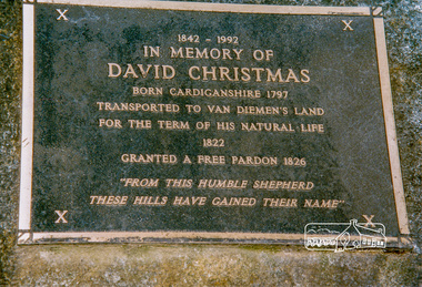
Photograph, David Christmas Memorial Plaque, Heritage Excursion, 22 October 1996, 22/10/1996
The David Christmas memorial is situated on the south side of One Tree Hill Road, at Watsons Creek. As a young man, Welshman David Christmas had been transported to Van Dienman's Land for a relatively minor offence. In 1836, having received a pardon, he came to Port Phillip, where, in 1842, he was hired as a shepherd by district pioneer, Joseph Stevenson. In 1992, a roadside plaque commemorating the shepherd who gave his name to the district was set in place over his presumed bush gravesite. The plaque was unveiled by two of Stevenson's grandsons, Bruce and Don Ness. FROM: Christmas Hills Past and Present, Yarra Glen & District Historical Society, 2004. The plaque reads: 1842-1992 In memory of David Christmas born Cardiganshire 1797 Transported to Van Dieman's Land for the term of his natural life 1822 Granted a free pardon 1826 "From this humble shepherd these hills have gained their name"Colour photographactivities, heritage excursion, david christmas, watsons creek, christmas hills, plaque -
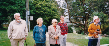
 Eltham District Historical Society Inc
Photograph, Peter Bassett-Smith, Upper Yarra Dam, Spring Tour, 22 Oct 1995, 22/10/1995
EXPLORING THE UPPER YARRA (Newsletter No. 105, November 1995, by Bettina Woodburn) We enjoyed the Spring Excursion, this year "Exploring the Upper Yarra" - in spite of the constant rain and the countryside under the cloud cover, especially in the valleys, being mainly shiny shades of green. The occasional fields of buttercups, clumps of arum lilies and splendid rhododendron and other flowering bushes became very special. The Cobb and Co coach was warm and a cosy retreat as we zig-zagged on the highways and byways to glimpse the Yarra River, upstream and down, its secret places, and particularly the many bridges. Russell excelled as 'Poet Laureate', reading from Dacre Smyth's book. This 1979 publication includes paintings of all the bridges along the river with poems and brief descriptions of each one. Some of the bridges are in out of the way places and are not very well known. We looked forward to hearing the poetry as much as seeing the ' constructions'…Big Pat (was he short or tall, lean or fat? He did win the two hundred pound reward for discovering gold and had the creek named after him), about the 'Eddies'?, and the disliked 'meccano' bridge in Warburton, etc. etc. The hot roast lunch in the old Reefton Hotel was also most welcome. It was easy to imagine it peopled by miners and early settlers. Starting by crossing the new (1974) concrete bridge at Warrandyte we headed through Wonga Park with views to the Christmas Hills and to the escarpment of the Yering Gorge, which causes flood waters to back up through the Yarra Glen plain, so avoiding disasters downstream. At the end of a long driveway we found the wooden, privately owned Henley Bridge (1935 after the 1934 floods). This facilitates access to different parts of Henley Farm and to Lilydale. Everard Park, named after Blanche Shallard's father, a State Member for 17 years, below the Highway Yarra crossing was in need of care. It is 10 miles from Yarra Glen by road but, as "Yarra Marra” canoeists well know, 32 winding miles down by water. After more delightful countryside scenes we joined the Warburton Highway at Woori Yallock. From the old Railway Station at Launching Place the Centennial Trail for walkers, cyclists and ' horse riders has replaced the rails. The line from Lilydale was opened in 1901, and the last diesel freight train ran to Warburton in 1965. It continued to rain as we had morning tea in Warburton in a shelter between footbridges. From here we continued upstream past the Bridge to O'Shannasy Lodge and Reservoir, Starvation Creek, and the Peninsular tunnel (miners dug it as at Pound Bend) which we visited (scrambling down those steps!) on our return after lunch. Our furthermost point was the Upper Yarra Dam Reserve (and vast catchment area). Finished in 1957 after ten years work and 100 years after Yan Yean, it supplies much of Melbourne's water. After crossing the 30m Launching Place Bridge to the Eltham side of the Yarra and Healesville, we saw in the distance the Yarra Glen Timber Trestle Bridge over the river flats "the longest for years in the land it was said!" Harry's dream of "better weather over the Divide" unfortunately didn't come true, but I'm sure we 36 members will retain happy memories of a day that was wet and green and filled with Bridges. Bettina Woodburn - October 1995 Record of the Society's history of activities - Spring 1995 excursionColour photographactivities, upper yarra dam, 1995, peter bassett-smith -
 Eltham District Historical Society Inc
Photograph, Peter Bassett-Smith, Upper Yarra Dam, Spring Tour, 22 Oct 1995, 22/10/1995
EXPLORING THE UPPER YARRA (Newsletter No. 105, November 1995, by Bettina Woodburn) We enjoyed the Spring Excursion, this year "Exploring the Upper Yarra" - in spite of the constant rain and the countryside under the cloud cover, especially in the valleys, being mainly shiny shades of green. The occasional fields of buttercups, clumps of arum lilies and splendid rhododendron and other flowering bushes became very special. The Cobb and Co coach was warm and a cosy retreat as we zig-zagged on the highways and byways to glimpse the Yarra River, upstream and down, its secret places, and particularly the many bridges. Russell excelled as 'Poet Laureate', reading from Dacre Smyth's book. This 1979 publication includes paintings of all the bridges along the river with poems and brief descriptions of each one. Some of the bridges are in out of the way places and are not very well known. We looked forward to hearing the poetry as much as seeing the ' constructions'…Big Pat (was he short or tall, lean or fat? He did win the two hundred pound reward for discovering gold and had the creek named after him), about the 'Eddies'?, and the disliked 'meccano' bridge in Warburton, etc. etc. The hot roast lunch in the old Reefton Hotel was also most welcome. It was easy to imagine it peopled by miners and early settlers. Starting by crossing the new (1974) concrete bridge at Warrandyte we headed through Wonga Park with views to the Christmas Hills and to the escarpment of the Yering Gorge, which causes flood waters to back up through the Yarra Glen plain, so avoiding disasters downstream. At the end of a long driveway we found the wooden, privately owned Henley Bridge (1935 after the 1934 floods). This facilitates access to different parts of Henley Farm and to Lilydale. Everard Park, named after Blanche Shallard's father, a State Member for 17 years, below the Highway Yarra crossing was in need of care. It is 10 miles from Yarra Glen by road but, as "Yarra Marra” canoeists well know, 32 winding miles down by water. After more delightful countryside scenes we joined the Warburton Highway at Woori Yallock. From the old Railway Station at Launching Place the Centennial Trail for walkers, cyclists and ' horse riders has replaced the rails. The line from Lilydale was opened in 1901, and the last diesel freight train ran to Warburton in 1965. It continued to rain as we had morning tea in Warburton in a shelter between footbridges. From here we continued upstream past the Bridge to O'Shannasy Lodge and Reservoir, Starvation Creek, and the Peninsular tunnel (miners dug it as at Pound Bend) which we visited (scrambling down those steps!) on our return after lunch. Our furthermost point was the Upper Yarra Dam Reserve (and vast catchment area). Finished in 1957 after ten years work and 100 years after Yan Yean, it supplies much of Melbourne's water. After crossing the 30m Launching Place Bridge to the Eltham side of the Yarra and Healesville, we saw in the distance the Yarra Glen Timber Trestle Bridge over the river flats "the longest for years in the land it was said!" Harry's dream of "better weather over the Divide" unfortunately didn't come true, but I'm sure we 36 members will retain happy memories of a day that was wet and green and filled with Bridges. Bettina Woodburn - October 1995 Record of the Society's history of activities - Spring 1995 excursionColour photographactivities, upper yarra dam, 1995 -
 Federation University Historical Collection
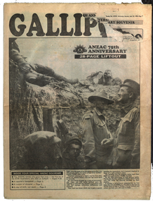
Newspaper Supplement, The Sun ANZAC Anniversary Souvenir, 22 April 1990, 22/04/2015
25 April 1915 is the date that the ANZAC troops landed at Gallipoli during World War One. After that year it has been commemorated as ANZAC Day.28 pages newspaper supplement relating to the 75th anniversary of the Gallipoli landing by the ANZACs during World War One. The supplement includes: List of 8100 ANZAC heroes who died at Gallipoli (pp 9-20), Keith Murdoch and his Gallipoli letter; Diary of Gallipoli Digger Apear Leslie de Vine, ceasefire for burial; Turkish soldiers; Simpson and his Donkey; Albert Henry Gayden's diary; Gallipoli nurses; Burial for a Lost Digger; Chunuk; Names of those who went to Gallipoli for the 70th anniversary An article by Geoffrey Blainey is headed 'A day not of death, but birth'. He states that Able Seaman Williams is the first Australian to be killed in action in the 1914-1918 war.james monro, john laffin, ian hamilton, keith murdoch, andrew fisher, ross bastiaan, albert jacka, leonard keysor, wiliam symons, alexander burton, william dunstan, frederick tubb, john hamilton, alfred shout, hugp throssell, albert gayden, ella tucker, bill cooper, jim douglas, walter parker, bob ponsford, tom meagher, claude franhauser, roy kyle, edmund thompson, jim kibble, robert barclay, roy longmore, jim lees, george fullerton, tom neal, stanley quinn, world war one, gallipoli -
Friends of Ballarat Botanical Gardens History Group
Work on paper - Carolus Clusius, 16th century scientific horticulturist, Wikipedia, 22/06/2009, 22/06/2009
Clusius's early work relates to some of the plants in the Ballarat Botanical Gardens today, for example, tulips. Carolus Clusius was a pioneering botanist and one of the most influential 16th century scientific horticulturists.2 pages with a photograph labelled Charles de l'Ecluse on the left of p.1 and a drawing of a Nymphaea on the lefthand side of the page. p.2 has a list of the works of Charles de l'Ecluse, bottom half of the page. Nonedoctor john garner, john garner, ballarat botanical gardens, friends of ballarat botanical gardens, 16th century, carolus clusius, charles de lecluse, l'escluse, pioneering botanist, scientific hoticulturist, tulips, alpine plants, genus clusia, european flora, john garner collection, gardens, ballarat -
 Melbourne Tram Museum
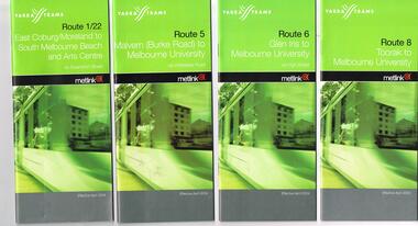
Ephemera - Timetable, Yarra Trams, Set of 22 Yarra Trams timetables, 2003 and 2004
Set of 22 Yarra Trams timetables, green grey cover with route number on cover, giving details of popular destination, check points, use of Metcards and contact details, tram hire, frequency, a Welcome to Swanston Trams, description of route and route map. .1 - Route 1/22 - East Coburg / Moreland - South Melbourne Beach and Arts Centre - April 2004 - 36 pages. .2 - Route 5 - Malvern (Burke Rd) - University - April 2004 - 32 pages. .3 - Route 6 - Glen Iris - City - April 2004 - 20 pages. .4 - Route 8 - Toorak - April 2004 - 20 pages. .5 - Route 16 - St Kilda Beach - University - April 2004 - 24 pages. .6 - Route 48 - North Balwyn to Docklands - May 2003 - 28 pages .7 - Route 57 - West Maribyrnong - City - April 2004 - 28 pages. .8 - Route 59 - Airport West - City - April 2004 - 32 pages. .9 - Route 64 - East Brighton - University - April 2004 - 28 pages. .10 - Route 67 - Carnegie - City - April 2004 - 20 pages. .11 - Route 70 - Wattle Park - City - May 2003 - 24 pages .12 - Route 72 - Camberwell - University - April 2004 - 28 pages. .13 - Route 78/79 - North Richmond - Prahran or St Kilda Beach - April 2004 - 20 pages .14 - Route 82 - Moonee Pond - Footscray - April 2004 - 20 pages. .15 - Route 109 - Port Melbourne to Box Hill - May 2003 - 28 pages. .16 - Route 112 - Sth Melbourne/St Kilda Beach to West Preston - May 2003 - 44 pages. .17 - Route 3 - East Malvern to Melbourne University - April 2004 - 20 pages .18 - Route 16 - Melbourne University to Kew - Oct. 2004 - 40 pages with fold out map .19 - Route 24 - North Balwyn to LaTrobe St and Route 30 - St Vincent's Plaza to Flinders St via Docklands - 8 pages. .20 - Route 69 - Kew (Cotham Road) to St Kilda Beach - April 2004 .21 - Route 86 - Bundoora to Central Pier - May 2003 .22 - Route 96 - St Kilda Beach to East Brunswick - Sept 2002Some have number notes and notes written inside about changes or errors in ink. See History.trams, tramways, yarra trams, tram services, timetables, route 1, route 3, route 22, route 5, route 6, route 8, route 16, route 24, route 30, route 48, route 57, route 59, route 64, route 67, route 69, route 70, route 72, route 78, route 79, route 86, route 96, route 109, route 112 -
 Federation University Historical Collection
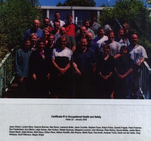
Photograph - Laminated Photograph - Colour, VIOSH: Certificate IV in Occupational Health and Safety; Intake 22, January 2002
Victorian Institute of Occupational Safety and Health (VIOSH) Australia is the Asia-Pacific centre for teaching and research in occupational health and safety (OHS) and is known as one of Australia's leaders in the field. VIOSH has a global reputation for its innovative approach within the field of OHS management. VIOSH had its first intake of students in 1979. At that time the Institution was known as the Ballarat College of Advanced Education. In 1990 it became known as Ballarat University College, then in 1994 as University of Ballarat. It was 2014 that it became Federation University. VIOSH Australia students are safety managers, senior advisors and experienced OHS professionals. They come from all over Australia and industry. Students are taught active research and enquiry; rather than textbook learning and a one-size fits all approach. VIOSH accepts people into the Graduate Diploma of Occupational Hazard Management who have no undergraduate degree - on the basis of extensive work experience and knowledge. Photograph of thirteen students enrolled in Certificate IV in Occupational Health and Safety: Intake 22, January 2002.Colour photograph laminated. Names of students under photographNames of studentsviosh, victorian institute of occupational safety and health, occupational health and safety, certificate iv, intake 22, january 2002, jason ahearn, lyndon barry, gwynne brennan, max burns, lawrence butler, jason crombie, stephen faure, robyn fisher, daniela fragale, peter freeman, ron friedrichsen, ann gibson, leigh guiney, alan hudson, natalie karacsay, margaret locarnini, john mcinnes, peter mckoy, dennis maltby, jackie mann, robert marsh, adele morton, mark nixon, robyn place, nathan ractiffe, max roscoe, paul smith, amanda tonks, martin ryan, derek van der heide, greg whitelaw, geoff wilkinson, megan wright -
 Vision Australia
Administrative record - Text, Queensland Society of Blind Citizens Minute book: 25/01/1972 - 22/10/1974, 1974-1976
Minutes of the Queensland Society of Blind Citizens committee including centre activities, staffing changes, fund raising appointment and resignation of committee members and life governorships. Some events include: 25/1/1972 - approaching the Townsville branch to ask if any applications for assistance for cyclone damage have been received, no benefits be paid to relatives doing work for members, the payment of 20 cents a week to the Queensland Musical Literary and Self Aid Society for rent of building until the Qld Society of Blind Citizens is formed and incorporated. 24/9/1974 - due to increasing utilities an increase to hostel board from $17 to $21 per week for all residents in employment. 22/10/1974 - call for special general meeting concerning dissolution of QML SAS and transferring assets and liabilities to QSBC, free use by the Coo-ee Fishing Club of the downstairs hall on Fridays and send a 'notice to fence' to the adjoining property in Stephens Road, South Brisbane. 1 book with typed pages stuck inqueensland society of blind citizens, queensland musical literary and self aid society for the blind -
Glen Eira Historical Society
Article - Long Street, 22, Elsternwick
Two items in the file (1) Typewritten notes, dated 03/02/1988, written by Mrs Rosalind Landells and researched by Miss Hilary Bullock regarding the history of 22 Long Street, Elsternwick and the street in general. Both sides of the page have notes, but are more or less the same in content. (2) The second item is an advertisement, dated 02/03/2005, source unknown, for 22 Long Street, Elsternwick regarding the sale of the house. The architectural and other features are described a copy of a photograph is included.elsternwick, caulfield grammar, rogers mark, long street, ripponlea, landells rosalind, caulfield, sargood, bullock hilary, glenhuntly road, victorian style, architectural features, st george’s road, buxton, advertisements, land sales, auctions, land subdivisions, depression 1890s, property developers, real estate agents, real estate agencies, corner stores, businesspeople -
Glen Eira Historical Society
Document - Shoobra Road, 22, Elsternwick
Two articles on 22 Shoobra Road Elsternwick: 1/Newspaper article from Residential Property Weekly dated 26/05/2000; includes photo. Gives detailed description of the late Edwardian home, interior features, carved timber archway, leadlighted doors, wall panelling and mouldings; includes room descriptions and family living area. 2/Handwritten notes on occupier of 22 Shoobra Road from 1910, 1913, 1923, 1942, 1948 and 1960 taken from Sands and McDougall by Claire Bartonelsternwick, shoobra rd, real estate agents, edwardian style, rowan street, arches, architectural features, lead lights, hocking stuart, parsons rea mdm, music teacher, bricks, flats, cooper montague, the bungalow -
 Vision Australia
Administrative record - Text, Royal Blind Society council meeting minutes 25/3/1968 to 22/11/1971, 1968-1971
These minutes contain information on attendees, meeting chairs, apologies, correspondence, subscriptions, donations, legacies and general business. Reports are also included from Auxiliaries, Auditors, Library and Home teacher, Directors, The Black and White committee, Victor Maxwell House, Helen Keller Hostel, The Victor Maxwell Kindergarten, The Sandy Robertson Kindergarten, Alexis Albert House, Lighthouse, Silver Lighthouse committee, Sheltered Workshops, Newcastle and Wollongong branches, 'Heathfield' and other Woollahra properties. 25/3/1968 it was resolved that Braille services be reorganised to Library, Transcription and Braille instruction for blind persons. This plan created 2 new positions for blind persons. 20/7/1969 it was resolved that a Burwood Building Fund would be opened with the donation of $2,000 by Mr. W. G. Waterhouse. 27/10/1969 it was resolved that sheltered workshop employees who retired after 25 years service would be presented with a gold Braille watch. 19/1/1970 it was resolved that the Society agrees to accept a first mortgage on the security of the William Street property. 22/3/1971 The General Manager had reported that Burwood Council had arranged to purchase the Palatial Theatre and had agreed to lease the building to the Society for 12 months. 1 volume of sheets glued to pagesroyal blind society of nsw, annual reports