Showing 231 items matching " aerial photography"
-
 Bendigo Military Museum
Photograph - Royal Australian Survey Corps - Map Production Processes, c1990
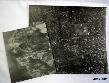
... , c1990. Set of overlapping aerial photography.... and Sydney. .20) – Photo, colour, c1990. Set of overlapping aerial ...This is a collection of 20 photographs of Royal Australian Survey Corps phases of map production at the School of Military Survey, Bonegilla, the Army Survey Regiment, Bendigo, and the Army Map Depot, Bandiana circa 1990. Colour photos are on 35mm slide film and were scanned at 96 dpi. They are part of the Army Survey Regiment’s Collection. Photo .1P was probably taken on a survey station overlooking Lake Hume near Albury-Wodonga. The field party occupying the survey station was likely from a Map Control Survey course conducted by the School of Military Survey, Bonegilla. This survey station was part of a geodetic network used in field survey training and RASvy’s Lake Hume Test Range. Photos .3P to .16P were taken at the Army Survey Regiment, Bendigo and photos .17P & .18P were taken at the Army Map Depot, Bandiana. Photo .19P depicts a map of RASvy’s ARA units before the disbandment of 5th Field Survey Squadron, Perth and 2nd Field Survey Squadron, Sydney in 1990. This is a collection of 20 photographs of map production processes taken at the School of Military Survey, Bonegilla, the Army Survey Regiment, Bendigo, and the Army Map Depot, Bandiana circa 1990. Colour photos are on 35mm slide film and were scanned at 96 dpi. They are part of the Army Survey Regiment’s Collection. Photo .2P is printed on photographic and scanned at 300 dpi. .1) – Photo, colour, c1980s. Geodetic Surveying: AN/PRR-14 Geoceiver antenna on hill surrounding Lake Hume. Series 3 Land Rover, field party tent and survey station beacon in background. .2) – Photo, black & white, c1980s. Geodetic Surveying: AN/PRR-14 Geoceiver antennas set up at the School of Military Survey, Bonegilla, Victoria. .3) – Photo, colour, c1990. Aerotriangulation: Wild PUG4 point transfer device, SSGT Bruce Hammond. .4) – Photo, colour, c1990. Aerotriangulation: Zeiss (Jena) Stecometer, SSGT Bruce Hammond. .5) – Photo, colour, c1990. Aerotriangulation: computer tape maintenance, SSGT Noel McNamara. .6) – Photo, colour, c1990. AUTOMAP 2: computer tape maintenance, SPR Nadine (Paul) Read. .7) - Photo, colour, c1990s. AUTOMAP 2: Optronics 4040 scanning/film output in Lithographic Squadron, SGT Sherri (Dally) Burke. .8) - Photo, colour, c1990s. AUTOMAP 2: Benson verification plotter output, SPR Nadine (Paul) Read. .9) – Photo, colour, c1990. Aerotriangulation: data management, SGT Neil ‘Ned’ Kelly. .10) & .11) - Photo, colour, c1990s. AUTOMAP 2: Wild B8 Aviograph stereoplotter Feature Extraction, unidentified technician. .12) - Photo, colour, c1990s. AUTOMAP 2: Graphic Edit Workstation, SPR Nadine (Paul) Read. .13) - Photo, colour, c1990s. AUTOMAP 2: Graphic Edit Workstation, SPR Dawn Hoadley. .14) & .15) - Photo, colour, c1990s. AUTOMAP 2: Graphic Edit Workstation, unidentified technician. .16) – Photo, colour, c1990s. Heidelberg Speedmaster 102 computer-controlled five colour lithographic offset printing press. .17) & .18) – Photo, colour, c1990s. Army Map Depot, unidentified storeman, Bandiana. .19) – Photo, colour, c1990. RASvy ARA Unit Locations before disbandment of field units in Perth and Sydney. .20) – Photo, colour, c1990. Set of overlapping aerial photography..1P, .3P to .20P - Some equipment is identified on the frame of the 35mm slides.royal australian survey corps, rasvy, army survey regiment, army svy regt, fortuna, asr, school of military survey, army map depot -
 Bendigo Military Museum
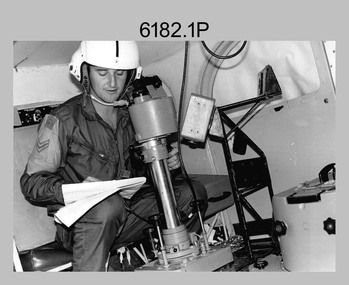
Photograph - Royal Australian Survey Corps Aerial Surveys, c1980
... station on aerial photography. Introduced in 1974–1975... the Royal Australian Survey Corps operating aerial surveys equipment ...This is a set of nine photographs of technicians from the Royal Australian Survey Corps operating aerial surveys equipment c1980s. In photo .1P, CPL Steve Gloster was operating a RC10 air survey camera mounted in an Australian Army Pilatus Porter aircraft. The Wild RC10 super wide-angle air survey cameras were first introduced in 1971, were equipped with virtual distortion free lenses for supplementary, spot and special photography. In photo .2P, Roger Rees was operating Air Profile Recorder (APR) equipment. it was possibly taken during OP NERVOSE 84, sometime between June – August 1984 when based in Ngukurr, Northern Territory. The APR was operated at this time in unison with an RC10 camera. In 1963 the Royal Australian Survey Corps introduced the radar airborne profile recorder (Canadian Applied Research Ltd, Mark V, Airborne Profiler Recorder) was introduced for 1:100,000 mapping to replace terrain heighting by aneroid barometry. Later in 1974-1975, the Australian developed WREMAPS II airborne laser terrain profile recorder was introduced. In photo .3P, Neil Jones appears at the door of Airsearch Beechcraft Queen Air aircraft, Registration / Serial VH-MWX. This aircraft was typically used by RA Svy on air survey operations flying mission with Aerodist, APR and RC10 camera equipment. The Australian Army’s Pilatus Porter (short take-off and landing turbo propeller) was also equipped with a Wild RC10 aerial mapping camera for identification photography. The Pilatus Porter was also used on RA Svy’s map field checking operations. Photo .9P was taken at a survey station at an unknown location. In this photo an Australian Army Kiowa Light Observation Helicopter (LOH) is supporting a field survey party undertaking Magnavox AN/PRR-14 portable Doppler satellite observations. The satellite receiver’s antenna is plumbed over the survey ground mark surrounded by white plastic panels. The panels were used to identify the survey station on aerial photography. Introduced in 1974–1975, the Magnavox AN/PRR-14 portable Doppler satellite (US Navy Navigation Satellite System – TRANSIT) receivers and computing system provided independent three-dimensional point positions anywhere in the world, anytime, in any weather accurate to about 1.5metres with precise satellite ephemerides. The Bell OH-58 Kiowa LOH was a family of military helicopters used for observation, utility, and direct fire support. It was identified by RA Svy in the mid-1970s that considerable time was lost in replacing unserviceable remote equipment by road. Therefore Aerodist operations (pre-dating satellite receiver operations) were fully supported by Army’s Kiowa LOH aircraft. This is a set of nine photographs of technicians from the Royal Australian Survey Corps operating aerial surveys equipment c1980s. .1P to .3P, .5P to .9P - Colour and black and white photos on photographic paper and scanned at 300 dpi. .4P - Colour photo on 35mm slide film and scanned at 96 dpi. .1) & .2) - Photo, black & white, c1980s, CPL Steve Gloster operating an RC10 air camera. .3) - Photo, colour, 1984, Roger Rees operating Air Profile Recorder (APR) equipment. .4) - Photo, colour, c1980s, Neil Jones at the door of an Airsearch Beechcraft Queen Air aircraft, typically used by RA Svy on air survey operations. .5) - Photo, colour, c1980s. A Beechcraft King Air aircraft, also used by RA Svy on air survey operations. .6) - Photo, colour, c1980s. An Australian Army Pilatus Porter, used by RA Svy on air survey and map field checking operations. SGT Peter Mustart is possibly in the foreground. .7) to .8) - Photo, colour, c1980s. An Australian Army Pilatus Porter and unidentified personnel, used by RA Svy on air survey and map field checking operations. .9) - Photo, colour, c1980s. An Australian Army Kiowa helicopter supporting a field survey party undertaking Magnavox AN/PRR-14 portable Doppler satellite observations. There are biro marks on photos .4P to .9Proyal australian survey corps, rasvy, army survey regiment, asr, fortuna, aerial surveys -
 Moorabbin Air Museum
Document (item) - Bill Prowse Collection WP14 See details in Description, Bill Prowse Collection WP14
... International Magazine 16/3/85 Techniques of Oblique Aerial Photography... Aerial Photography of agricultural Field trials CSIRO Alata ... -
 Orbost & District Historical Society
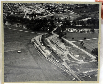
aerial photograph, 1970's
This photograph was taken prior to the closure of the Orbost -Bairnsdale freight line in 1987.The Orbost-Bairnsdale railway initially played a crucial role in developing agricultural industries in Gippsland as well as tourism. It opened in 1916 and operated until 1987, principally carrying timber and farming produce. In the early days of the railway's operation dedicated passenger trains ran but these ceased by the 1930s. The line was completely closed to freightage in 1987.The track infrastructure was dismantled in 1994 and has been redeveloped as the East Gippsland Rail Trail.A large black and white aerial photograph of Orbost Railway Station in the foreground and the Orbost township in the background. It has been pasted onto a piece of Masonite. railway photography orbost, railway photography orbost -
 Bendigo Military Museum
Photograph - Johnson Ground Elevation Meter (JGEM) Survey Vehicle - Army Survey Regiment, Fortuna, Bendigo, c1960s
This is a set of 16 photograph of the Royal Australian Survey Corps’ Johnson Ground Elevation Meter (JGEM) Survey Vehicle taken at the Army Survey Regiment, Fortuna, Bendigo. The JGEM vehicle was extensively used by RA Svy within Australia from the late 1960s. A limited number of Ground Elevation Meter (GEM) station wagon type vehicles were manufactured by General Motors Corporation (GMC) in the USA for the United States Geological Survey, Canada’s mapping agencies, RA Svy and National Mapping (Natmap). The GEM was a four-wheel drive, four-wheel steer vehicle. Four-wheel steering was necessary to avoid systematic errors caused by non-tracking of front and rear wheels on conventionally steered vehicles. The manufacturer substituted the rear axle with a front axle and connected them to form the four-wheel steering mechanism. The two Australian GEM vehicles, referred to as Johnson GEMs (JGEMs) were converted into right-hand drive. After delivery in 1964, acceptance Natmap and RA Svy testing and operator training was undertaken at the Army's School of Military Survey located at Balcombe, Victoria. A small fifth wheel was mounted on a cantilever arm suspension midway between the front and rear wheels on the right side of the vehicle. It was lowered to and raised from its operating position by use of a constant pressure air cylinder. A telescopic bar, suspended between the front and rear axles, provided the reference datum for the angle measurement. The wheel provided the velocity or distance signal through a pulse generator system. A sensitive pendulum mounted on this bar provided the angle measurement for each minute distance traversed. The JGEM contained electromechanical instruments used to determine relative elevations, by trigonometric principles, along a traversed path. These relative elevations were obtained through apparatus which measures the instantaneous angle of inclination of the road and the instantaneous velocity of the meter along such a path. Road routes over which the JGEM operated were planned so that each started and ended as near as practicable to an existing point of known elevation (formally referred to as a level traverse bench mark). The difference in height from the bench mark and the road surface alongside the JGEM’s fifth wheel was measured with a level and staff. Along each route, mapping control photo reference points where new elevation values were required were identified on aerial photographs. Under favourable conditions it was possible to survey as much as 160km in an ordinary working day. The first of RA Svy’s JGEM operations was undertaken in 1:250,000 scale map areas of Queensland. CPL John Hook was the JGEM’s main operator in the early 1970s undertaking operations covering 1:250,000 scale map blocks over northern Victoria and central NSW, each requiring 36 points (9 runs of photography and 4 points across. SPR Lyn Thompson and SPR Bob McDonagh teamed with CPL Hook on some of these JGEM operations. When RA Svy was integrated into the Royal Australian Engineers in 1996, the JGEM vehicle with the Survey Corps collection was donated to its museum. It is believed to be the last of the original manufactured fleet in existence. The JGEM has undergone extensive refurbishment to achieve roadworthiness and is currently housed at The Australian Army Museum of Military Engineering, Hoslworthy Barracks, NSW. It can be viewed by making an appointment with the museum’s curator.This is a set of 16 photograph of the Royal Australian Survey Corps’ Johnson Ground Elevation Meter (JGEM) Survey Vehicle taken at the Army Survey Regiment, Fortuna, Bendigo. The photographs were on 35mm slide film and were scanned at 96 dpi. They are part of the Army Survey Regiment’s Collection. .1) - Photo, colour, c1960s, Johnson Ground Elevation Meter (JGEM) Survey Vehicle .2) - Photo, colour, c1960s, JGEM instrumentation, on-board computer. .3) - Photo, colour, c1960s, JGEM instrumentation. .4) - Photo, colour, c1960s, JGEM instrumentation, on-board computer. .5) - Photo, colour, c1960s, JGEM tyre pressure controller .6) - Photo, colour, c1960s, JGEM rear doors, SGT Geoff Briggs. .7) - Photo, colour, c1960s, JGEM 5th wheel distance/angle measurement device in lowered position, SGT Geoff Briggs. .8) - Photo, colour, c1960s, JGEM 5th wheel distance/angle measurement device in lowered position. .9) & .10) - Photo, colour, c1960s, JGEM tyre pressure system, SGT Geoff Briggs. .11) - Photo, colour, c1960s, JGEM tyre pressure system. SGT Geoff Briggs. .12) - Photo, colour, c1960s, JGEM levelling scope, levelling staff, unidentified technicians. .13) & .14) - Photo, colour, c1960s, JGEM levelling scope, unidentified technician. .15) & .16) - Photo, colour, c1960s, probably survey operation adjusted height plotted on block base sheet. .1P to .16P - Some of the equipment is annotated on the frame of the 35mm slides.royal australian survey corps, rasvy, army survey regiment, army svy regt, fortuna, asr, surveying -
 Bendigo Military Museum
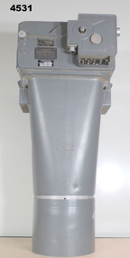
Equipment - AIR CAMERA ACCESSORY, Williamson Mfg. Co. Ltd
This Gear box universal, with its Cone assembly ( inc lens) in conjunction with Magazine 500 exposures unit ( see CAT 5561) is part of the F22 aerial camera assembly. As an assembly, the type F22 aerial camera came into RAF and RAAF service c1942. It was used by the RAF over Europe and by the RAAF extensively through the Sth. West Pacific area of operations, during WW2. This type of camera was used through the Vietnam war up to the early 1980's. The F22 camera assembly when mounted in the reliable Canberra aircraft, did aerial survey work in PNG, Indonesia, Malaysia and Sumatra and the Australian mainland. This type of camera was used in Spitfires, Mosquitos, Avro Lincolns and Canberra aircraft.Heavy, metal construction. The base is a rectangular box shape and mounted to that is a funnel shaped tube. Inside the tube are numerous small baffles around the sides painted matte black. The box has a 7 pin electrical connector. The box section can be opened by releasing catches. It has a timber base. Near the mouth of the tube, outside, is a panel with a slot and indentations F5.6 F8 F11 F16.There is a tape label near mouth if tube with writing embossed "LENS S/NO 2767849" The box has a label "GEARBOX/UNIVERSAL. MODEL 14A/4249 SERIAL No. 1685"aviation, reconnaisance, camera, photography -
 Bendigo Military Museum
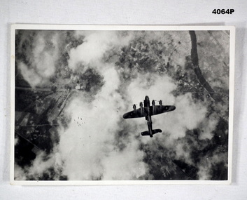
Photograph, c.WWII
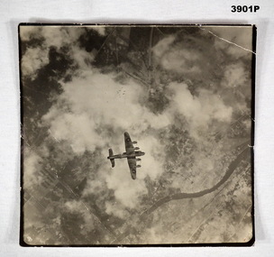
Photograph of a Lancaster bomber on a bombing mission. Bombs released by the aircraft are visible. Part of Frederick Gardner Davey DFC No.410533 RAAF collection. See Cat. No. 3536P for his service record.Photo, black & white, white border, aerial photograph of an aircraft dropping a stick of bombs over a target. Ground target partially visible through clouds.On back, handwritten in blue ink: "I.M. Davey Pres. C.W.A. Strathdale. 'Stick of bombs going down'".bombing run, photography, ww2 -
 Bendigo Military Museum
Memorabilia - PHOTOGRAPH, c.WWII
British Lancaster Bomber releasing bombs over a target. EAW is marked on the side of the bomber . Item re Frederick Gardner DAVEY DFC No 410533 RAAF. Refer Reg No 3536P for his service details.Black / white aerial photo of a British aircraft flying over land partly covered by cloud. A stick of bombs released by the aircraft is visible.On back - Handwritten in blue ink: Stick of bombs going down Stamped: Crown copyright reservedphotography, lancaster, raaf -
 Bendigo Military Museum
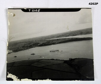
Photograph - AERIAL PHOTO, Possibly 1944
Photo in the collection of Reginald Charles Allardice No 418557 RAAF. Refer Cat No 3627.5 for his service details.B & W photo showing land and sea with one large ship and several smaller ones.On front, “T2105”. On rear in pencil,” Hospital ship Dorsetshire P.D 1 od.44 A/Z01”, stamped on rear “Crown copyright reserved”, above this as part of the stamp “A crown image M”photography, hospital ships -
 Bendigo Military Museum
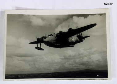
Photograph - SUNDERLAND PHOTO, Post 1943
Item in the collection of Reginald Charles Allardice No 418557 RAAF. Refer Cat No 3627.5 for his service details.Aerial B & W photo of a Sunderland Flying Boat over land. On the rear a paper is pasted to with typed writing in purple.On rear, “ BRITISH OFFICIAL PHOTOGRAPH, No CH 3210 Air Ministry photograph - crown copyright reserved. On patrol, a short Sunderland Flying Boat of the RAF Coastal Command sets out on a patrol. This particular aircraft is flown by the RAAF Squadron operating with Coastal Command The Sqd is on the 9,000 hours flying mark during its 16 months operating duty in this country”photography, sunderlands, military -
 Bendigo Military Museum
photograph - PHOTOGRAPHS WW2, 2053) 24/10/1943; 2053.1) 17/09/1944
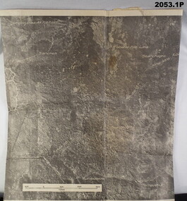
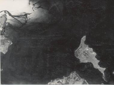
2053.1) Photo's "Aerial", Binder form, 4 pages, paper yellowed, photo's written on, area description under each one. B&W. 2053.2) Photo, large Aerial, B&W, "Vunakanau Plantation". Photo written on showing military positions, scale. Mosaic, Toma to Dieldimans Corner (Vunakanau) 17 Sep 1944.photography-photographs, military history - airforce, aerial -
 Bendigo Military Museum
Photograph - AERIAL PHOTOGRAPHS WW2, 1942 - 1944
... . photography-photographs-military Aerial Most images: Locations ...Various reconnaissance photographs depicting targets in Timor for attack by the R.A.A.F. Items saved by Maurice Anthony BYRNE RAAF. Refer Cat No 215.9 for his service details.37 Aerial reconnaissance photographs of various locations over Timor and surrounding islands 1 Envelope: original container of photographs.Most images: Locations, including Latitude and Longitude marked on the backphotography-photographs-military, aerial -
Frankston RSL Sub Branch
Recorder, Camera
This is a Camera Gun Recorder used in conjunction with a Gyro Gun Sight type 14A, G. G. S. Recorder Mk2 contained in a wooden box with hinged lid and retaining catch. The recorder consists of a metal enclosure with an electrical power supply cable fitted with a three pole female plug connector. A small access cover in the enclosure can be opened to replace the Recorder Magazine. There is a transparent aperture window on the underside of the enclosure.The recorder enclosure is inscribed with the Department of Defence mark and the following, "14A/3629, G.G.S., RECORDER, Mk2, 24V., XX 12012". There are small controls on the narrow side of the recorder which are marked "START, 0, 5, 10, 15, END" and "DULL, S.S. BRIGHT". The recorder magazine is inscribed with the Department of Defence mark and the following "14A/4008, G.G.S., RECORDER, MAGAZINE, MKII". raaf, royal australian air force, gun, fighter, photography, ww2, world war 2, camera, aircraft, bomber, aerial -
Phillip Island and District Historical Society Inc.
Photograph, circa 1940
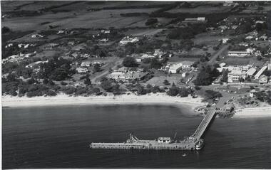
... history photography photographs slides film aerial view of cowes ...Commercially available print made approx 1940s. Bayview Guesthouse burn down in 1950s.L shaped Jetty, left, Jetty Shed at end. Large trees along beach front. Thompson Avenue middle showing most buildings on right. Bayview Guesthouse in foreground right.Valentine Series (rest cut short)local history, photography, photographs, slides, film, aerial view of cowes, black & white photograph, foreshore, jetty -
Phillip Island and District Historical Society Inc.
Photograph, circa 1940
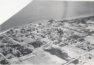
... . local history photography photographs slides film aerial views ...Commercially printed approx 1940s. Bayview Guesthouse (lower right foreshore) was burnt down in 1950s.Jetty diagonally lower left - township in foreground - open paddocks in background. Thompson Avenue & Cypress trees lower middle to upper right. Taken approx 1940sAerial view of Cowes Phillip Island No. 147local history, photography, photographs, slides, film, aerial views of cowes, phillip island, black & white photograph, aerial views cowes -
 Phillip Island and District Historical Society Inc.
Photograph, 1950
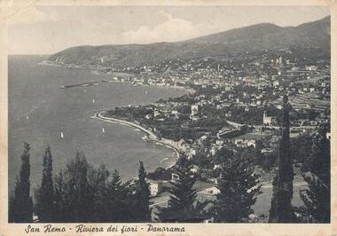
... to relative (Aunt Elsie) in San Remo dated 17/06/1951 photography ...Personal communication from Europe to relative (Aunt Elsie) in San Remo dated 17/06/1951Aerial view of San Remo coastline with row of various Pine Trees across foreground. Hills in background. Pier at top left. Shows town area of San Remo in Italy, Europe.San Remo - Riviera Dei Fiori - Panoramaphotography, photographs, aerial view - coastal view - san remo europe, black & white photograph, comparison views san remo, aerial -
Phillip Island and District Historical Society Inc.
Photograph
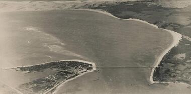
Photograph from The Herald and donated by Jack MorrisonBlack & White Aerial Photograph showing the two bridges between Newhaven and San Remo, the old and the new.local history, photography, photographs, slides, film, civil engineering, bridges, history of the phillip island bridge, black & white photograph, phillip island bridge -
Phillip Island and District Historical Society Inc.
Photograph
Photograph from The Herald and donated by Jack MorrisonBlack & White Aerial Photograph showing the two bridges between Newhaven and San Remo, the old and the new. (Same photo as 100-09, reduced in size)local history, photography, photographs, slides, film civil engineering, bridges, history of the phillip island bridge, black & white photograph, phillip island bridges -
Phillip Island and District Historical Society Inc.
Photograph, ?
Part of collection of Photographs donated to the Museum by The Family of late Mr. Jack Jenner (1977).Sepia Postcard - Valentine Series - Aerial view of Cowes & Pier.View of Cowes, Phillip Island, from the air. Valentine Series No. 1616.local history, photography, photographs, slides, film, view cowes, sepia photograph, jack jenner, aerial view cowes, valentine series -
Phillip Island and District Historical Society Inc.
Photograph
Phillip Island suspension Bridge built 1938/1940 - demolished 1970. Part of an album compiled and donated by Mrs Helen Jansson.Print of Phillip Island Suspension Bridge. Aerial view showing Jetties at left with sweep of sandy beaches middle to top left.No. 1. Phillip Island Bridge, Victoria. Airapy Photolocal history, photography, photographs, slides, film, civil engineering, bridges, jetties, phillip island suspension bridge, black & white photograph, mrs. helen jansson, suspension bridges, phillip island -
 Phillip Island and District Historical Society Inc.
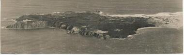
Photograph, Bryant West
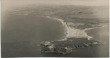
One of a collection of over 400 photographs in an album commenced in 1960 and presented to the Philip Island & Westernport Historical Society by the Shire of Phillip IslandAerial Photograph of Cape Woolamai.local history, photography, photographs, coastline, cape woolamai, phillip island, john jenner, bryant west -
 Phillip Island and District Historical Society Inc.
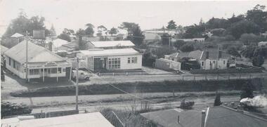
Photograph, 1960
One of a collection of over 400 photographs in an album commenced in 1960 and presented to the Phillip Island & Westernport Historical Society by the Shire of Phillip IslandAerial photograph of the Cowes Kindergarten in Chapel Street, Cowes. Now next to the Cowes State School in Settlement Road. (JG 2017)local history, photography, cowes kindergarten, black & white photograph, kindergartens, chapel street cowes, john jenner, bryant west -
 Phillip Island and District Historical Society Inc.
Photograph, Bryant West
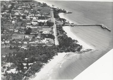
One of a collection of over 400 Photographs in an Album commenced in 1960 and presented to the Phillip Island & Westernport Historical Society by the Shire of Phillip IslandAerial photograph of Cowes, Foreshore and Jetty looking west.local history, photography, photographs, cowes jetty foreshore, foreshore jetty cowes, aerial view of cowes phillip island, john jenner, bryant west -
 Phillip Island and District Historical Society Inc.
Photograph, Bryant West
One of a collection of over 400 photographs in an album commenced in 1960 and presented to the Phillip Island & Westernport Historical Society by the Shire of Phillip Island.Aerial photograph - panoramic view of Cowes looking north-east with Jetty and Foreshore in backgroundlocal history, photography, photographs, cowes foreshore, jetty, cowes, beaches, aerial view of cowes, aerial view of cowes phillip island, john jenner, bryant west -
 Phillip Island and District Historical Society Inc.
Photograph, Bryant West
One of a collection of over 400 photographs in an album commenced in 1960 and presented to the Phillip Island & Westernport Historical Society by the Shire of Phillip Island.Aerial Photograph of Cape Woolamai looking north-west.local history, photography, photographs, coastline, cape woolamai, aerial view of cape woolamai, john jenner, bryant west -
 Phillip Island and District Historical Society Inc.
Photograph, Bryant West
One of a collection of over 400 photographs in an album commenced in 1960 and presented to the Phillip Island & Westernport Historical Society by the Shire of Phillip Islandaerial photograph, part of Cowes Township and beach with Jetty in foregroundlocal history, photography, photographs, part cowes township - cowes beach and jetty, cowes township, beach, jetty, john jenner, bryant west -
 Phillip Island and District Historical Society Inc.
Photograph, Bryant West
One of a collection of over 400 photographs in an album commenced in 1960 and presented to the Phillip Island & Westernport Historical Society by the Shire of Phillip IslandAerial Photograph of Phillip Island Bridge - Newhaven to San Remo.local history, photography, photographs, civil engineering, bridges, bridge, newhaven, san remo, phillip island, coastline, suspention bridge phillip island, john jenner, bryant west -
 Phillip Island and District Historical Society Inc.
Photograph
One of a collection of over 400 photographs in an album commenced in 1960 and presented to the Phillip Island & Westernport Historical Society by the Shire of Phillip IslandAerial photograph of Churchill Island taken in 1939.local history, photography, churchill island, black & white photograph, coastline, islands, churchill island aerial view, john jenner, bryant west -
 Phillip Island and District Historical Society Inc.
Photograph, Bryant West
One of a collection of over 400 photographs in an album commenced in 1960 and presented to the Phillip Island & Westernport Historical Society by the Shire of Phillip IslandAerial Photograph of Phillip island Bridge and Cleeland's Bight.local history, photography, photographs, civil engineering, bridges, phillip island bridge, coastline, bridge, phillip island, cleeland's bight, eastern passage phillip island, john jenner, bryant west -
 Phillip Island and District Historical Society Inc.
Photograph, 1921
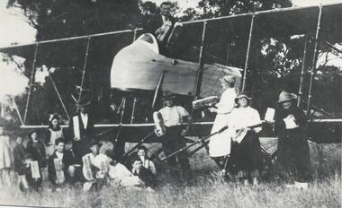
One of a collection of over 400 photographs in an album commenced in 1960 and presented to the Phillip Island & Westernport Historical Society by the Shire of Phillip IslandPhotograph of the aeroplane and the first aerial delivery of bread at Rhylstone Park, Cowes Phillip Island, 1921local history, photography, aeroplane delivering bread, black & white photograph, aeroplanes, aerial bread delivery, john jenner, bryant west