Showing 401 items matching " balwyn road"
-
 Kew Historical Society Inc
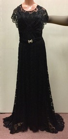
Clothing - Black lace evening dress, 1930s
... to 25 Corhampton Road, North Balwyn. She died in May 1980... to 25 Corhampton Road, North Balwyn. She died in May 1980 ...Doris Mercy Willmott was born in May 1896 in Stamford Hill, London, the eldest of three daughters of Albert and Minnie Willmott. The family lived in various parts of north London until the beginning of the First World War, when they moved to Redhill in Surrey. It was in Redhill that Doris met her future husband, Frederick John (Jack) Bennett. Jack had met Eric Mercy, a cousin of Minnie’s, in the Australian Imperial Force (AIF) and visited the Wilmotts with him whilst on leave from France. Although Jack Bennett returned to Melbourne in March 1919, he and Doris continued to correspond and they were engaged in March 1923. She came to Melbourne on her own, and was married in the Congregational Church in Canterbury on 23 December 1923. By 1931 Doris and Jack and their three sons - John Willmott, Winfield Robert Curtis and Peter Reginald Dane - moved to 21 Tooronga Road, Hawthorn but moved back to his father’s home, Therapia, 2 (now 6) Hepburn Street, Auburn, shortly before his father’s death. In 1937, the Bennett family moved back to the United Kingdom, spending the war years in Uxbridge and Torquay. The family returned to Melbourne in October 1946, after the deaths of Doris’ parents. The family lived at 12 Stanhope Grove, Camberwell and 51 The Ridge, Canterbury before Jack died in February 1952. After this Doris moved to 12 Stanley Grove, Canterbury, her home until c. 1970 when she moved to 25 Corhampton Road, North Balwyn. She died in May 1980 in Princeton Nursing Home, 3 Bellett Street, Camberwell. (Adapted from notes provided by Sue Barnett, the donor).The collection of evening clothes owned and worn by Doris Mercy Bennett, of which this item is one, date from the 1930s and may have been purchased in Australia or in the United Kingdom. Each of the items, apart from the evening dress, which has a few minor tears in the lace, is of fine quality and evidences Doris Bennett’s love of glamour and style. While the evening dress and the mantilla are of the same fabric, the two capes might have been worn with the dress as alternative fashion accessories. None of the items has a maker’s mark, however each displays evidence of fine dressmaking skills. It is however probable that the two fitted capes were commercially made.Long black lace, floor-length evening dress extending to a short train at the back. The dress has a belt at the waist that is joined by two white metal clasps studded with diamentes. With the dress there is also a matching lace square (2017.00921) that might have been used as a mantilla or as a shawl. The dress was owned and worn by Doris Mercy Bennett (nee Willmott) [1896-1980], and donated to the Society by her grandaughter. women's clothing, evening wear, evening dresses, doris bennett (nee wilmott) -
 Kew Historical Society Inc
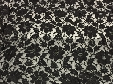
Clothing - Evening Wear, Black Lace Shawl, circa 1930s, 1930s
... to 25 Corhampton Road, North Balwyn. She died in May 1980... to 25 Corhampton Road, North Balwyn. She died in May 1980 ...Doris Mercy Willmott was born in May 1896 in Stamford Hill, London, the eldest of three daughters of Albert and Minnie Willmott. The family lived in various parts of north London until the beginning of the First World War, when they moved to Redhill in Surrey. It was in Redhill that Doris met her future husband, Frederick John (Jack) Bennett. Jack had met Eric Mercy, a cousin of Minnie’s, in the Australian Imperial Force (AIF) and visited the Wilmotts with him whilst on leave from France. Although Jack Bennett returned to Melbourne in March 1919, he and Doris continued to correspond and they were engaged in March 1923. She came to Melbourne on her own, and was married in the Congregational Church in Canterbury on 23 December 1923. By 1931 Doris and Jack and their three sons - John Willmott, Winfield Robert Curtis and Peter Reginald Dane - moved to 21 Tooronga Road, Hawthorn but moved back to his father’s home, Therapia, 2 (now 6) Hepburn Street, Auburn, shortly before his father’s death. In 1937, the Bennett family moved back to the United Kingdom, spending the war years in Uxbridge and Torquay. The family returned to Melbourne in October 1946, after the deaths of Doris’ parents. The family lived at 12 Stanhope Grove, Camberwell and 51 The Ridge, Canterbury before Jack died in February 1952. After this Doris moved to 12 Stanley Grove, Canterbury, her home until c. 1970 when she moved to 25 Corhampton Road, North Balwyn. She died in May 1980 in Princeton Nursing Home, 3 Bellett Street, Camberwell. (Adapted from notes provided by Sue Barnett, the donor).The collection of evening clothes owned and worn by Doris Mercy Bennett, of which this item is one, date from the 1930s and may have been purchased in Australia or in the United Kingdom. Each of the items, apart from the evening dress, which has a few minor tears in the lace, is of fine quality and evidences Doris Bennett’s love of glamour and style. While the evening dress and the mantilla are of the same fabric, the two capes might have been worn with the dress as alternative fashion accessories. None of the items has a maker’s mark, however each displays evidence of fine dressmaking skills. It is however probable that the two fitted capes were commercially made.With the black lace evening dress (2917.0093.1) there is also a matching lace square with long lace ties (2017.0093.2) that might have been used as a mantilla or as a shawl. The outfit was owned and worn by Doris Mercy Bennett (nee Willmott) [1896-1980], and donated to the Society by her grandaughter. women's clothing, evening wear, shawls, lace, doris bennet (nee willmott) -
 Kew Historical Society Inc
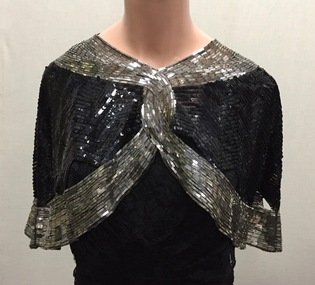
Clothing - Evening Wear, Black and Silver Sequin Capelet, 1930s, 1930s
... to 25 Corhampton Road, North Balwyn. She died in May 1980... to 25 Corhampton Road, North Balwyn. She died in May 1980 ...Doris Mercy Willmott was born in May 1896 in Stamford Hill, London, the eldest of three daughters of Albert and Minnie Willmott. The family lived in various parts of north London until the beginning of the First World War, when they moved to Redhill in Surrey. It was in Redhill that Doris met her future husband, Frederick John (Jack) Bennett. Jack had met Eric Mercy, a cousin of Minnie’s, in the Australian Imperial Force (AIF) and visited the Wilmotts with him whilst on leave from France. Although Jack Bennett returned to Melbourne in March 1919, he and Doris continued to correspond and they were engaged in March 1923. She came to Melbourne on her own, and was married in the Congregational Church in Canterbury on 23 December 1923. By 1931 Doris and Jack and their three sons - John Willmott, Winfield Robert Curtis and Peter Reginald Dane - moved to 21 Tooronga Road, Hawthorn but moved back to his father’s home, Therapia, 2 (now 6) Hepburn Street, Auburn, shortly before his father’s death. In 1937, the Bennett family moved back to the United Kingdom, spending the war years in Uxbridge and Torquay. The family returned to Melbourne in October 1946, after the deaths of Doris’ parents. The family lived at 12 Stanhope Grove, Camberwell and 51 The Ridge, Canterbury before Jack died in February 1952. After this Doris moved to 12 Stanley Grove, Canterbury, her home until c. 1970 when she moved to 25 Corhampton Road, North Balwyn. She died in May 1980 in Princeton Nursing Home, 3 Bellett Street, Camberwell. (Adapted from notes provided by Sue Barnett, the donor).The collection of evening clothes owned and worn by Doris Mercy Bennett, of which this item is one, date from the 1930s and may have been purchased in Australia or in the United Kingdom. Each of the items, apart from the evening dress, which has a few minor tears in the lace, is of fine quality and evidences Doris Bennett’s love of glamour and style. While the evening dress and the mantilla are of the same fabric, the two capes might have been worn with the dress as alternative fashion accessories. None of the items has a maker’s mark, however each displays evidence of fine dressmaking skills. It is however probable that the two fitted capes were commercially made.Black silk chiffon or georgette fitted evening cape,let entirely covered in silver metal rectangles and black sequins. The cape gives the appearance of being joined at the front, however it is made in one piece. The cape has open scalloped sections bordering the lower band of silver metal rectangles. The cape was owned and worn by Doris Mercy Bennett (nee Willmott) [1896-1980], and donated to the Society by her grandaughter. evening wear, capelets, doris bennett (nee wilmott), women's clothing -
 Kew Historical Society Inc
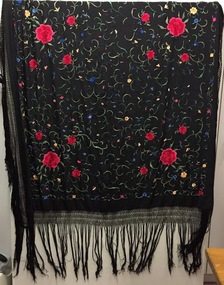
Clothing - Shawl, Manton de Manila, 1930s
... to 25 Corhampton Road, North Balwyn. She died in May 1980... to 25 Corhampton Road, North Balwyn. She died in May 1980 ...Doris Mercy Willmott was born in May 1896 in Stamford Hill, London, the eldest of three daughters of Albert and Minnie Willmott. The family lived in various parts of north London until the beginning of the First World War, when they moved to Redhill in Surrey. It was in Redhill that Doris met her future husband, Frederick John (Jack) Bennett. Jack had met Eric Mercy, a cousin of Minnie’s, in the Australian Imperial Force (AIF) and visited the Wilmotts with him whilst on leave from France. Although Jack Bennett returned to Melbourne in March 1919, he and Doris continued to correspond and they were engaged in March 1923. She came to Melbourne on her own, and was married in the Congregational Church in Canterbury on 23 December 1923. By 1931 Doris and Jack and their three sons - John Willmott, Winfield Robert Curtis and Peter Reginald Dane - moved to 21 Tooronga Road, Hawthorn but moved back to his father’s home, Therapia, 2 (now 6) Hepburn Street, Auburn, shortly before his father’s death. In 1937, the Bennett family moved back to the United Kingdom, spending the war years in Uxbridge and Torquay. The family returned to Melbourne in October 1946, after the deaths of Doris’ parents. The family lived at 12 Stanhope Grove, Camberwell and 51 The Ridge, Canterbury before Jack died in February 1952. After this Doris moved to 12 Stanley Grove, Canterbury, her home until c. 1970 when she moved to 25 Corhampton Road, North Balwyn. She died in May 1980 in Princeton Nursing Home, 3 Bellett Street, Camberwell. (Adapted from notes provided by Sue Barnett, the donor).Black silk, with multi-coloured embroiderery Manton de Manila shawl. The shawl was owned and once worn by Doris Mercy Bennett (nee Willmott) [1896-1980], and donated to the Society by her grandaughter. It probably dates from the 1930s.evening wear, piano shawl, manton de manila, doris bennett (nee wilmot), women's clothing -
 Eltham District Historical Society Inc
Folder, Commercial Bank of Australia Eltham Branch Hold-Up, 15 December 1949
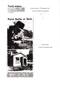
... from Helen Baxter, of Doncaster Road, North Balwyn from outside... from Helen Baxter, of Doncaster Road, North Balwyn from outside ...Thursday, December 15, 1949, the quiet little bank was embroiled in an infamous wild shoot-out between a daring thief and two bank officers. Today, the building still carries the scars ; a bullet hole remains visible in a cedar bench testifying to the events that played out that day. 3.30 a.m., Friday, December 9. The manager of the Commercial Bank branch at Greensborough, Mr Harry Wallace and his wife are asleep in their bedroom of the little house behind the branch. Harry is awakened by a noise and sees an intruder in a corner of the bedroom. He calls out but the intruder who has switched off the power in anticipation flees through a side door and scarpers down Main Street. Harry summons the police but a search by First Constable Thomas of the Greensborough Police assisted by a wireless patrol car is unsuccessful. A report is filed noting the theft of a .25 calibre pistol from the wardrobe. Thursday, December 15th. It is 1pm and the Commercial Bank has just opened. The branch is only open Mondays and Thursdays from 1-3pm. The morning started off a little cool with some scattered showers but it has fined up and the temperature is now around 61 degrees (16 C). A new grey Singer sports car with soft-top pulls up on the opposite side of the road and a young man, neatly dressed in a dark blue suit, wearing a grey hat and carrying a brief case exits the vehicle. He looks around then crosses the road and walks up the steps and through the door into the bank. There are three people inside; Mr. Jack Burgoyne whose grocery store is situated just 50 yards up the road, Mr. Lindsay A. Spears, the Eltham Agency Receiving Officer and by chance, Mr Harry Wallace, manager of the Greensborough branch. Jack Burgoyne takes note of the young stranger; thinking to himself he appears nervous. The man approaches the counter and introduces himself as John Henderson of Greensborough and explains that he wishes to open a new account. He places his hat and £3 on the counter. Mr Spears attends to the paperwork. He asks the young man to sign two forms, which he does but then he withdraws from the counter and starts walking towards the door. Suddenly he spins around pulling an automatic pistol from his right-hand pocket. He exclaims forcefully; “The game’s on! I’ll take the lot!” Spears appears to comply by pretending to open a drawer. The man shouts loudly, “Keep your hand away from that drawer.” Spears instead reaches for a pistol in his pocket and challenges the man, “Here it is. Come and get it!” At the same time, Harry Wallace pulls a pistol from his pocket as well. The bandit fires a shot but misses, the bullet striking the counter. Both Spears and Wallace open fire and Jack Burgoyne ducks for cover. As the bandit turns and runs for the door leaving his £3 behind, he fires another shot, which strikes the ceiling. Spears fires back, and thinks he may have hit him in the foot. The bandit flees the bank and heads for the grey Singer car, registration NO-106, parked opposite. Wallace and Spears pursue him to the door and open fire again, striking the car three times around the driver’s door. Spears lets off eight shots and Wallace, seven before his gun jams. The getaway car initially heads slowly down Main Road towards Bridge Street. About 100 yards down the road, Dave Adams, a PMG employee, who has heard the shots, throws a steel manhole step at the driver. It hits the roof of the car nine inches above the driver’s head and tears the hood. Another witness claims to have seen the door blow open and the driver raise his hand. The car gathers speed and swings left into Bridge Street racing along at about 60 miles an hour careering recklessly past council employee, Mr. Percy Williams, who is driving a dray along Smarts Road [believed to be Bridge Street]. At the end of the road the Singer fails to get round the sharp turn and crashes into an embankment skidding to a stop outside the home of Mr John Clifford. One side of the car is wrecked. Mr Clifford, an aircraft engineer hears the fast travelling car bump heavily into the road bank at about 1.25 p.m. Hearing the whine of an engine he goes outside to find the grey Singer parked at the side of the road. Jack George also lives at the corner and hears the car crash. “The bandit opened the car door, ran 50 yards, and suddenly turned back,” exclaims Jack. “He took something from the car. It might have been a gun.” In his haste, the bandit drops his grey felt hat, size 6 7/8, on the road and dashes up Sherbourne Road for about 200 yards then disappears into the scrub carrying a brief case and a bundle in which a sailor’s cap can be seen. About 3 p.m., Mr H.D. Pettie of Mountain View Road, Montmorency is looking through his field glasses and notices a young man walking through thick scrub on private property some distance from his house. The man is wearing a sailor’s cap and disappears along the railway track toward Montmorency. As the day progresses, ten police cars, one motor cycle, and about 40 police led by Det. Sgt. McMennemin of Malvern CIB are searching for him. They believe he is hiding in thick scrub along the bank of the creek about half-a-mile outside Eltham township. Wireless patrol cars, four mobile traffic cars and the CIB area cars from Malvern and Kew are taking part. Police check the thief’s car and discover it was stolen from Helen Baxter, of Doncaster Road, North Balwyn from outside Victoria Barracks. Harry Wallace informs the police that he believes he recognised the bandit as the man who took his pistol from his bedroom the previous Friday morning. As night falls, armed police are posted at strategic points in the Eltham-Greensborough district. Police in cars are watching the roads. Others are searching the bush and checking passengers on trains. Little do they realise the young man has already slipped out of the net. SEQUEL YOUTH OF 19 CHARGED WITH ATTEMPTED ARMED ROBBERY OF BANK AT ELTHAM Weekly Times, Wednesday 15 February 1950, page 6 Detectives who raided a house in Bell St., Coburg, Melbourne, charged a 19-year-old youth, of South Yarra, with attempted armed robbery at the Commercial Bank’s Eltham (Vic.) receiving depot on Dec. 15. Police say they recovered a loaded automatic pistol, diamond and signet rings worth more than £200, a complete set of house-breaking instruments, a sailor’s uniform, and chloroform gauze in the raid. The youth was charged that while armed with an offensive weapon, he attempted to rob Lindsay George Spears of a sum of money. He was further charged on six counts of breaking, entering and stealing. Police allege that the person who tried to hold up Mr Spears in the Commercial Bank receiving depot at Eltham on December 15. escaped in a stolen car, after Mr Spears and Mr Henry Wallace, manager of the bank’s Greensborough branch, had fired at him. After the car crashed, he escaped into thick scrub and is alleged to have changed into a sailor’s uniform. On December 9 an automatic pistol was stolen from Mr Wallace’s bedroom at the Greensborough bank. The chloroform pad recovered is alleged to have been stolen from the Dental Supply Company, Plenty Road, Preston. The rings are alleged to have been taken in a £513 burglary from the shop of James Paton. Sydney Road, Coburg. Det. Sgt. H. McMennemin conducted the investigations with Senior Dets. R. Newton and M Downie, Detectives l. Dent, R. Rayner, P. Pedersen and M. Handley and First Constable A. Thomas. The youth will appear at Eltham Court on February 22. Manager’s Gun Used in Holdup at Bank The Age, Thursday 23 February 1950, page 4 It was stated in Eltham court yesterday that a youth who robbed a bank manager of his pistol, later used it in an attempt to hold-up the bank. Kay Arthur Morgan, 19, draftsman, of Castle-street, South Yarra, was committed for trial on charges of breaking and entering, and stealing a pistol and attempted robbery while armed with an offensive weapon. He pleaded guilty. The manager of Eltham branch of the Commercial Bank of Australia Ltd., Henry Clifton Cabot Wallace, said he disturbed someone in the bedroom, in which he and his wife were sleeping, at 3 a.m. on December. 9, 1949. Later he found that his automatic- pistol was missing. On December 15 a youth, who said his name was John Henderson, entered the bank and opened a new account. As the youth was leaving the bank he turned round with a pistol in his hand and said: — “I want the lot.” Spear indicated a drawer under the counter; and said.— “Here it is. Come and get it.” The youth said:— “Keep your hand away from that drawer.” Witness said Spear then drew his pistol from his hip pocket. The youth fired at them, and Spear returned the fire. “I pulled my pistol and fired, too” said witness. The youth fired again, ran out to a car and drove off. Witness and Spear fired several shots at the car. The youth was the accused Morgan, sitting in court, witness said. Evidence was given that one bullet was found in the celling and the other in the bank. Morgan was allowed £100 bail on each charge. Morgan ended up serving three years for the failed armed robbery and became a notorious criminal. He had twin sons, Peter and Doug and even though only ten years old, Morgan would get his sons to act as lookouts whilst he committed burglaries. The lads became building contractors but when the industry suffered a downturn in 1977 and they were short on cash, they returned to the family business. Over the following 23 months they undertook 24 raids on country and outer-suburban TABs and banks. Whilst robbing one country bank for the third time, just like their father, it all went wrong ending up with a police officer shot. They were nick-named the “After-dark” bandits and are considered to be Australia’s last bushrangers. They were convicted and served 17 years in prison.5 x A4 photocopied pagesbank hold-up, cba bank, det sgt mcmennemin, eltham, h.d. pettie, harry wallace, jack burgoyne, kay arthur morgan, lindsay a. spears, main road -
 Melbourne Tram Museum
Album - Photo Album, John Etkins, Ray Marsh, 1990's
... Road, Balwyn 5-10-1991 30 976 x 2 pics Advert tram – have... flyover 29 V214 x 3 pics Kew Depot 30 611 Whitehorse Road ...Photo Album - 48 sheets bound with a white circular metal/plastic spiral bound within a heavy duty cardboard cover, with glued cover pages, plastic covered with an index sheet. Allows for three photographs per page. Not known whether the plastic envelope for each photograph is of archival quality. No Manufacture detail, though has a bar code on the bottom left hand corner of the rear cover. Cover is a reproduction from a painted art piece. Listing of photographs given on htd1800-RayMarshalbum.pdf Dates given when written on the rear of the photograph. Compiled by John Etkins from photographs given to him by Ray Marsh. 1990's to 1993 generally. Page Tram/s Notes – dates given when on rear of photograph. 1 226 Loading passengers – ex MMTB Annual Report? 1 957 City Circle 1 “hands off our trams” protest march 2 2100, 231 South Melbourne Depot – 10-4-1993 2 676 And many others – Hawthorn Depot 2 217 Princes Bridges 3 380, 104 St Kilda Road 3 106, 104 Essendon Depot 3 431 As a W1 4 1011 Fresh fruit tram, Preston Depot 6-12-1992, 4 824 Day in Day out, Brunswick and Victoria Parade 29-4-1993 4 722 Art tram 5 ? Advert tram – Imperial China 5 237 Stubbsy tram – TrippleM? 6 856 City Circle – with gas and fuel building – 31-7-1994 6 925 City Circle - with gas and fuel building – 31-7-1994 6 728 City Circle – 10-8-1994 7 246 Navy tram x three pics – July 1992 8 ? Gold tram advertising Georges 8 990 Advertising Telstra– 29-4-1993 8 749 Art tram? 9 990 NRMA - 1-3-1994 9 727, 215 Public Transport 9 920 Advert tram with a picket fence 10 Bendigo 21 Preston Workshops 11-3-1993 10 774? W5 being rebuilt at Preston – 21-10-1991 11 ? Bogie cable trailer at Preston – 29-4-1993 11 922 Interior view of a tram – being modernised – 11-3-1993 11 922 Preston Workshops 29-4-1993 12 1018 Workcare tram at Preston 1994 – 11-8-1994 12 774 Preston Workshops – 20-12-1993 12 8 Preston Workshops – 1-10-1992 13 380 Preston Workshops 13 8 Preston Workshops 13 20, 8 Preston Workshops 14 721 Preston Workshops 20-12-1993 14 ? Tramways painted artist tram featuring a driver and workshop 14 Traverser Preston Workshops 15 2110, 2106 Preston Workshops 15 ? Preston Workshops 15 2130 Interior Preston Workshops 20-12-1993 16 Set of three pics Elizabeth St floods – 17-2-1972 17 Set of three pics Elizabeth St floods – 17-2-1972 18 676 Turning into Swanston St from Batman Ave 18 676 Kew Depot – 10-11-1991 18 237, 676, 611 Kew Depot – 10-11-1991 19 214, 676 South Melbourne Depot – Kingsway 19 217 Spencer St 19 214 Advertising Kew Depot Open Day -8-12-1991 20 231, 676 Advertising Kew Depot Open Day -8-12-1991 20 Zoo tram, 256 Outside Kew Depot 20 214 Hawthorn Open Day with band 21 Zoo tram x 3 pics And horses, Kew Open day 22 231, 431 Kew Depot 22 892, 214 Kew Depot 75 years, Postcard – 1991 22 282 Kew Depot – with the name Monique on the tram and a lady standing alongside 23 238, 233 Kew Depot 23 236, 892, 282 Kew Depot – 25-4-1992 23 232, 236, 282 Kew Depot 24 2112 Port Melbourne line – with long grass – 11-4-1993 24 469, 2037, ? 2015 South Melbourne Depot 24 1018 or 976? Advertising a PTC Open Day – 20-10-1991 – In Swanston St - see Reg Item 1845 25 250 Bourke St 25 2100 Running into Preston Workshops 25 282, 1003 Collins St in the rain 26 Logo PMTT 26 Point cover With P&MTT cast into the cover 26 Foundation Stone Person reblocking in gold, a PMTT Foundation Stone 27 Logo Tramway Board 27 Logo MMTB logo 27 Logo Footscray Tramways Trust 28 217 And 2’gauge W2 – South Melbourne Depot – 20-10-1991 28 164 Somewhere? 28 1018 Advert tram – “Moro”, Preston flyover 29 V214 x 3 pics Kew Depot 30 611 Whitehorse Road, Balwyn 5-10-1991 30 976 x 2 pics Advert tram – have a red instead 31 610 Malvern Depot 31 138 (max tract) Flinders St 31 138 (max tract) Bourke into Spencer 32 844 Victoria Parade with R10 behind 32 264 With a TV interview being undertaken 32 2066 Elizabeth St – 29-4-1993 33 255 x 2 pics Derailed at Kew Depot 33 253 Derailed outside the Beehive Hotel 34 214, 892, 611 Re-enactment of Victoria Bridge to Esplanade service – 10-11-91 34 726 Art tram? – Swanston St with overhead trucks in background 34 10W Reblocking scrubber car at Brunswick Depot 1999 35 2085 At Preston workshops over an inspection track section 35 731 St Georges Road, road being rebuilt – Nov. 1991 35 Preston Jtn Junction at Workshops being relaid 36 1003 St Georges Road, Nov. 1991 trackworks 36 St Georges Rd Track being rebuilt – Nov. 1991 has temp track cross over 36 Victoria St Victoria St being reconstructed 6-9-1992 37 East Burwood Extension works – 18-2-1993 37 East Burwood Re-building crossover – 18-2-1993 37 Victoria St Victoria St being reconstructed 6-9-1992 38 19W, 16W Bylands – 5-12-1993 38 R10 Kew Depot 38 Workers Kew Depot pushing on a post 39 R10 R10 towing a B class tram- Royal Parade? 39 11W, 10W? South Melbourne Depot 39 Overhead Overhead truck at Kew Depot 40 Kew Depot Demolition works opposite depot 40 613? Malvern Depot on special tram 40 256 zoo tram Royal Park tram at Kew Depot 41 B class Bundoora line 1993 41 231, 611 Kew depot 75th anniversary tram 41 469, 287 Kew depot 42 510 Spring St into Bourke St – 28-4-1993. “42nd street promotion. 42 153 High St Northcote, Bundoora 42 611 Kew Depot, Nov. 1991 43 195? Simpson St siding – 25-4-1993 – 7 trams in all 43 646 Route 12, with fire station in background – Gisborne and Victoria 43 961 Burke Road, Camberwell, 10-8-1994 44 760 Art tram 44 938 Sam the tram, Flinders St 44 1014 Gilbert Road, West Preston, June 1994, advert for AGC 45 965 Daimaru advert tram, Swanston St 45 1018 Express post advert tram, Swanston St. 45 1024 Advert – lego exhibition – Swanston St 46 104 Camberwell depot 46 611 Looking towards driver’s controls from interior. 46 W1 Interior photo showing tip over seats 47 Cable car Interior photo – could be zoo tram 47 510 Interior, 28-4-1993 47 214 Kew Depot, night shot, Oct. 1991 48 246, 237 Kew depot, 13-9-1993 – Stubbsy and Energy Victoria advert 48 246, 231, 237 Kew depot, Navy, 75th anniversary of Kew and Fox Fm advert 48 2014, 2072 South Melbourne – tt line? Advert tram 49 59 And six other trams in front of Preston Workshops 49 1024 MMTB Christmas Tram, 1970 49 2001 Camberwell Depot 50 725 Preston depot area – tram has a red upper half 50 725 South Melbourne depot – now has Xmas decorations 50 1026 Bourke St, Christmas 6-12-1993 51 933 Victoria Parade shunt and other A class tram – Autumn 51 829 Art tram 51 39 Advert tram – Crime prevention 52 Connie Connie at night = has jeans on 52 1?? Has a MET inspector standing in front of number – Latrobe uni tram 52 611 Kew Depot 53 237 Fox FM Black Thunder tram at Kew Depot, August 1992 53 237, 611, 892 Victoria Bridge re-enactment – 10-11-1991 53 237 At Kew depot with 4 people, including Hugh Waldron 53 442, 10W South Melbourne Restaurant tram and works car 53 W2 At Wattle Park 53 School art Photo of students holding artwork on the zoo tram 256 at Kew 54 138 And many others 54 469 Launch of the Melbourne Tram by the PTC 54 School art Photo of students holding artwork on the zoo tram 256 at Kew 55 B2 Elizabeth St terminus, Christmas 1994 55 8 Z8 Swanston St, April 1993 55 504 Clifton Pugh – Preston Workshops 56 138, 180, 214 Hawthorn Depot display 56 650, 510 Hawthorn Depot 56 469 Camberwell 57 568 Bridge Road Richmond by cable tram depot 57 ? Advert tram – Falls Creek 57 995 Malvern Road, 18-5-1992 58 457, 217 etc Swanston St display 58 231, 611 Kew 75th Anniversary 58 682 Artist tram at Malvern Depot – 18-5-1992 59 1018 Country Road advert tram 59 8 Z class – decorated tram – Essendon Depot 59 947 Metland Safety Express – safety tram – Kew depot 60 101 x 2pics Decorated for RAAF 70th Anniversary 60 2082 Near East Preston Depot, with destination “Next Stop Mill Park” 61 475 After sale and disposal 61 585 After sale and disposal 61 651 After sale and disposal – Diamond Creek – 9-8-1994 62 386 After sale and disposal – Sunbury 62 590 After sale and disposal – Hall ACT 62 476 After sale and disposal – Kinglake 63 11W Bundoora Extension – track being opened 63 947 Metland Safety Express – safety tram – Kew depot 63 Model 2,3 2’ gauge model trams 64 Model 2 Ditto 64 250 After sale and disposal 64 293 After sale and disposal – Diamond Ck – 9-8-1994 65 246, 231, 237 Kew depot, Navy, 75th anniversary of Kew and Fox Fm advert 65 1002 Advert tram – Salvation Army 65 231, 29 Kew Depot 66 246, 231, 237 Kew depot, Navy, 75th anniversary of Kew and Fox Fm advert 66 646, 935, 1002 Kew depot 66 220, 60 Preston Workshops? 67 851, 814 Malvern Depot 3-9-1992 67 726 Malvern Rd at Glenferrie Road – 18-5-1992 67 237, 133 Victoria Parade 1996 68 814 and others Interior Malvern Depot – 18-5-1992 68 231 75th Kew depot anniversary at depot 68 231 75th Kew depot anniversary at depot 69 1024 Malvern Depot 10-11-1991 69 1011 Advert tram Melbourne City Toyota 69 106, 180 Swanston St 70 190, 568 Camberwell Depot 70 431 Flinders St – tram event 70 20, 138 Camberwell Depot 71 431 Flinders St – tram event 71 237 Fox FM Thunder Tram 71 2057, 2014 Elizabeth St, Vic Market 29-4-1993 72 676, 611, 892 Victoria Bridge re-enactment – 10-11-1991 72 Ceremony Victoria Bridge – mayor and others event 72 214 214 on the bridge 73 164 Lygon St – former outer circle line level crossing in view 73 841 Swanston Walk 29-4-1993 74 821 St Georges Road, April 1993 74 431, 231 Victoria Parade 74 217, 676 Passing Camberwell Depot 75 Oporto 018 Clarendon St 6-3-2003 75 3007 Albert Park – 7-3-2003 75 3001, 018, 3502 Docklands – 10-3-2003 76 Oporto 018 Docklands – 16-1-2003 76 Oporto 018 Flinders St 7-3-2003 76 3502 Swanston St at Flinders St -8-3-2003 77 16 Kew Depot, Jan 1991 77 112, 110 Bundoora 4-9-1992 77 738 Camberwell Feb 1991 78 1011 Thornbury Jan 1991 advert for City Toyota 78 101 Bundoora – RAAF tram 4-9-1992 78 814 Art tram – Swanston St August 1992 79 1024, 469, Z3 Preston Workshops – 469 as the Melbourne Tram – 9-9-1992 79 961 Malvern Depot 3-9-1992 79 242 Single line working in Victoria St 6-9-1992 80 781 Thornbury, the hump, Preston Workshops Jan 1991 80 2104 Preston Workshops 9-9-1992 80 2100 Launch, Preston Workshops 9-9-1992 81 5W + 1A 5 x W at Kew Depot 3-2-1991 81 676 Kew Depot 21-2-1991 81 873, 2016 Brunswick depot 2-3-1991 82 231 Kew Depot Yard – 21-1-1991 82 157, 158 Brunswick Depot – 2-3-1991 82 2057, 873, 158 Brunswick Depot – 2-3-1991 83 802 Art Tram - Franklin St from the signal box 2-3-1991 83 990 990 Evian advert tram, Franklin St signal box 2-3-1991 83 920 GIO Advert Tram with Bushels tea and Yellow Pages? Adverts 84 721 Art Tram, Franklin St signal box 84 976 St Georges Road, Jan 1991 – advert tram Capital society 84 731 St Georges Road, Jan. 1991 Art tram 85 10W Victoria Parade, Brunswick St, 1/3/1991 85 10W, 9 or 11W South Melbourne depot 85 10W Bundoora Terminus 4-2-1991 86 11W City Baths 86 10, 16 Camberwell Depot 6-12-1990 86 944 Glenhuntly Depot 18-2-1991 87 2011 Spring St – Princess Theatre, March 1990 87 294, 239, 277, 243, 259, 280 Kew Depot 87 296 Kew Depot 88 1015, 16 Batman Ave 19-1-1991 88 963, 948, 935, 996, 892 Kew Depot 3-2-1991 88 Victoria St Victoria St Richmond Reconstruction 6-2-1992 89 1014, 990 Batman Ave 19-1-1991 (Image added i5 and rear view added 23-12-2018, scanned for Dale Budd. 89 920 920 – GIO advert tram, 760 art Tram Collins at Spencer 17-10-1990 89 610, 611 Kooyong Station level crossing 30-12-1990 90 95 Royal Park, 15-2-1991 90 2057, 873, 158 Brunswick Depot – 2-3-1991 90 10 Camberwell Depot 6-12-1990 91 Bendigo 44 In Prahran and Malvern Tramways Trust Colours 1986 –Black and white photo. Listed 5-11-2016See note page 1 and on image 3trams, tramways, album, photo album, tramcars, the met, yarra trams, kew depot, brunswick depot, advertising trams, transporting art, preston depot, hawthorn, bundoora, st georges rd, victoria st, camberwell depot, tram r10, 8, 10w, 10, 11w, 16, 16w, oporto 018, 19w, 20, bendigo 21, 29, 39, bendigo 44, 59, 60, 95, 101, 104, 106, 110, 112, 133, 138, 153, 157, 158, 164, 180, 190, 195?, 214, 215, 217, 220, 226, 231, 232, 233, 236, 237, 238, 239, 242, 243, 246, 250, 253, 255, 256, 259, 264, 277, 280, 282, 287, 293, 294, 296, 380, 386, 431, 442, 457, 469, 475, 476, 504, 510, 568, 585, 590, 610, 611, 613?, 646, 651, 676, 682, 721, 722, 725, 726, 727, 728, 731, 738, 749, 760, 774, 781, 802, 814, 821, 824, 829, 841, 844, 851, 856, 873, 892, 920, 922, 925, 933, 935, 938, 944, 947, 948, 957, 961, 963, 965, 976, 990, 995, 996, 1002, 1003, 1011, 1014, 1015, 1018, 1024, 1026, 2001, 2011, 2014, 2015, 2016, 2037, 2057, 2057, 2066, 2072, 2082, 2085, 2100, 2104, 2106, 2112, 2130, 3001, 3007, 3502 -
 Greensborough Historical Society
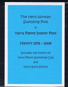
Folder (article and photographs), The Herb Norman Swimming Pool and Yarra Plenty Indoor Pool, history 1976-2008, comp. by Helen Webb, with a foreword by Rosie Bray, 2019_
History of the Herb Norman Swimming Pool, opened in 1978 and originally used by Watsonia High School; acquired by the Balwyn Yarra Swimming Club in 1984, which changed its name to the Yarra Swim School in the late 1980s. Includes the history of the Yarra Plenty Swimming Club and Yarra Swim SchoolLarge folder containing colour photographs, newspaper clippings and textyarra plenty swimming club, yarra swim school, watsonia high school, herb norman -
 Greensborough Historical Society
Article - Website, Welcome to Yarra Swim School, 08/02/2019
Originally the Balwyn-Yarra Swimming Club which commenced operation in 1984/85 at Watsonia High School, the Yarra Swim School has expanded greatly over the years.Text and colour photographs; with "Swim Australia 20 Years" colour sign"Registered Swim School 2017-2018"yarra swim school -
 City of Moorabbin Historical Society (Operating the Box Cottage Museum)
Bandage, cotton, mid 20thC
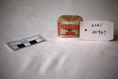
A bandage is a piece of material used either to support a medical device such as a dressing or splint, or on its own to provide support to the body; it can also be used to restrict a part of the body. G. J. Coles opened the 'Coles Variety Store' on 9 April 1914 on Smith Street in the Melbourne, Victoria suburb of Collingwood. Further expansion occurred and Coles' interest in food retailing was spurred in 1958 when it acquired 54 John Connell Dickins grocery stores. It then acquired the Beilby's chain in South Australia in 1959 and 265 Matthews Thompson grocery stores in New South Wales in 1960 .In 1960, the first supermarket was opened in the Melbourne suburb Balwyn North, at the corner of Burke and Doncaster Roads where a modernised version continues to operate. By 1973, Coles had established stores in all Australian capital cities. From 1962, its supermarkets were branded Coles New World with accompanying rocket imagery. In 1991, the stores were re-branded Coles Supermarkets and from 1998, simply as Coles. George James (G. J.) Coles learned the retail trade working for his father's 'Coles Store' business from 1910 to 1913. The store continued operating as "The Original Coles" at Wilmot, Tasmania until it was destroyed by a fire on 24 January 2014. An unused, 1 inch ( 2.5cm ) x 6 yards ( 2metres) cotton, ‘open wove’ bandage in a cellophane wrapper sold by G.J. Coles Pty Ltd Variety StoresCellophane wrapper top: WHITE OPEN WOVE / BANDAGE / 1 X 6 YDS. / SPECIAL QUALITY / G.J.COLES * pharmacy, medicines, bandages, wounds, early settlers, market gardeners, moorabbin, bentleigh, cheltenham, cotton, gauze, coles g j pty ltd., variety stores, supermarkets, smith street collingwood, retailers, shops -
 Ringwood and District Historical Society
Document, Norman H. Cooper, died 1949 aged 59 years, former Manager of SEC Ringwood, 1949
Norm Cooper served in WW1 then worked in the State Electricity Commission (Victoria). He lived in Ringwood (later Balwyn) played football, cricket, tennis and was a member of the Children's Hospital Auxiliary. Collection donated by Annette Rattray - a distant relative.Obituaries and photographs relating to the life of Norman H. Cooper. Collection includes summary of Military Service and association with Ringwood branch of the Victorian State Electricity Commission. -
 Ringwood and District Historical Society
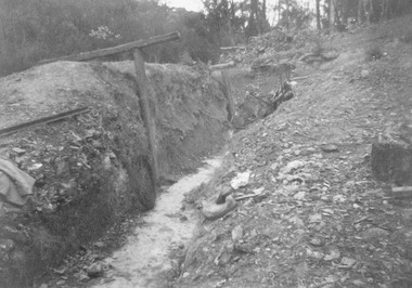
Photograph, Ringwood Rifle Club. Target pit being dug out. (undated)
Black and white photograph (3 copiesCatalogue card reads "Ringwood Rifle Club. Target pit being dug out. Land leased from S. Philpots, North Balwyn, alongside Jumping Creek Reserve, South Warrandyte. (3 copies) -
 Ringwood and District Historical Society
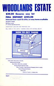
Flyer, Land Sale Advertisement - Woodlands Estate, North Ringwood, Victoria - circa 1970
... Road, North Balwyn...., 264 Doncaster Road, North Balwyn. Double sided single-page ...Double sided single-page advertisement for land sale with locality map and layout of Woodlands Estate subdivision in North Ringwood, with summary of local features and services. No indication of date of flyer other than post-Eastland Shopping Centre opening in 1967.Subdivision includes Oban Road, Terrigal Close, Dorelaw Drive (later Melview Drive), Naroo Court, and Barook Court. Agent's rubber stamp imprint - H.C. Walton & Son, 264 Doncaster Road, North Balwyn. -
 Bendigo Historical Society Inc.
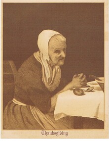
Document - MALONE COLLECTION: INVITATION METHODIST CHURCH BALWYN, 1936
... An invitation to 20th Holiness Convention Burke Road... Burke Road Methodist Church Balwyn. Printed in brown on buff ...An invitation to 20th Holiness Convention Burke Road Methodist Church Balwyn. Printed in brown on buff coloured card with illustration of old woman on front & a religious poem on the back. Printed by F W Niven Pty Ltd. 40 - 42 Flinders St Melbourne C2.person, invitation, malone collection, malone collection, invitation methodist church balwyn -
 Uniting Church Archives - Synod of Victoria
Plaque
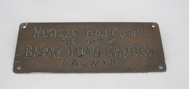
... "Nurses Balcony the gift of Burke Road Church Balwyn"... Balcony the gift of Burke Road Church Balwyn" Brass plaque ...Brass plaque on varnished wood mount."Nurses Balcony the gift of Burke Road Church Balwyn"methodist babies' home -
 Whitehorse Historical Society Inc.
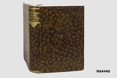
Book, <1940
The book was owned by the donor's father who lived at North Balwyn. There is no date of printing or of editing as the original offices of Odhms Press were bombed during the war, which makes this an original copy,Brown artificial leather covered book with gold lettering on the spine and an embossed emblem on the cover.The Universal Home Doctor Illustratedbooks, medical -
 Whitehorse Historical Society Inc.
Article, Laurel Martyn, 1994
Advertisement for Victorian Ballet School in Syndal, Balwyn and Wantirna, also photograph of Laurel Martyn ' Life in the Jete set'Advertisement for Victorian Ballet School in Syndal, Balwyn and Wantirna, also photograph of Laurel Martyn ' Life in the Jete set'Advertisement for Victorian Ballet School in Syndal, Balwyn and Wantirna, also photograph of Laurel Martyn ' Life in the Jete set'martyn, laurel, victorian ballet school, ballet and dance -
 Whitehorse Historical Society Inc.
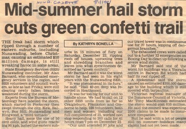
Article, Mis-summer hail storm cuts green confetti trail, 9/01/1991 12:00:00 AM
Destruction following a freak hail storm that came through Box Hill, Nunawading, starting in Footscray.Article describes the destruction following a freak hail storm that came through Box Hill, Nunawading, starting in Footscray.Destruction following a freak hail storm that came through Box Hill, Nunawading, starting in Footscray.hail storms, nunawading, state emergency service, barnard, alan, australia. bureau of meteorology, footscray, kew, balwyn, box hill, insurance council of victoria, mackintosh, tony -
 Whitehorse Historical Society Inc.
Book - Social Studies Reader, c1960
Used by Chris Gray at Balwyn State School 1960sRed covered book with drawing of the world globe and two chickens and a ''swaggie'' animal--''Life and Legends of Many Lands''. Whitcombe's Social Studies Reader Book 1.books, school/educational, school, equipment -
 Whitehorse Historical Society Inc.
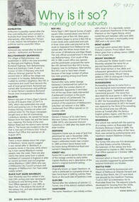
Article, Why Is It So?
How the eastern suburbs were named.ashburton, ashwood, ballyshanassy, balwyn, blackburn, black flat, box hill, burwood, camberwell, canterbury, deepdene, forest hill, glenferrie, glen iris, glen waverley, hawthorn, mont albert, mount waverley, nunawading, riversdale, surrey hill, vermont, wattle park -
 Whitehorse Historical Society Inc.
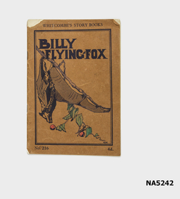
Booklet - Children's story book, Billy Flying Fox, C 1940
Example of children's story booksSee aboveStory book, part of extensive series for children aged 7-8."Presented to Allan Kepert, Balwyn Baptist Primary 1.11.42"children's story books -
 Whitehorse Historical Society Inc.
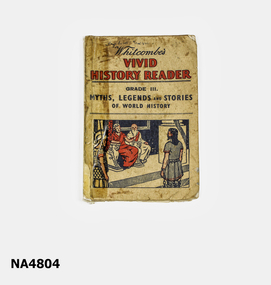
Book - Vivid History Reader, Cira 1965
Used by Chris Gray at Balwyn State School.School history readerCream coloured book with no back cover. Cover has written on it: "Whitcombe's Vivid History Reader Grade III Myths, Legends and Stories of World History" Front cover picture Roman soldier, man in chains, and two men sitting. Has names Angeline Giveria(?) on cover and page 1 and Christopher Gray on inside cover school book, history reader, chris cray -
 Ballarat Tramway Museum
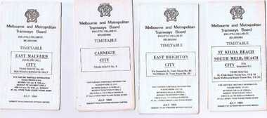
Ephemera - Timetable/s, Melbourne and Metropolitan Tramways Board (MMTB), Set of 24 MMTB Melbourne tram timetables, 1969
Set of 24 MMTB timetables for various routes, dated July 1969. Generally includes Sat and Suns, Good Friday and Christmas day as well as weekdays, unless noted otherwise. Also includes a map of the route, detailed time points, sections, connecting services, fares, and organisation address - 616 Little Collins St. Melbourne. Have been folded into ten portions. All on white paper unless noted otherwise. Items shown with an # - have a sticker modifying timetable information details on the front page. 1154.1 - Route 4 - Carnegie - City .2 - Route 4D - East Malvern (Darling Road) - City # .3 - Route 5 - Malvern Burk Road, - City # .4 - Route 6 - Glen Iris - City # .5 - Route 7 - Camberwell - City # .6 - Route 8 - Toorak - City # .7 - Routes 9, 10 and 12 - South Melbourne and St Kilda Beach - City (Brunswick St.) - via Collins St. .8 - Routes 10, 11 - West Preston and routes 9 & 9A Northcote .9 - Routes 15 & 22 - Moreland and 1 & 21 - East Coburg .10 - Route - 15 & 16 - St Kilda Beach and 1 & 2A - South Melbourne Beach - via Swanston St. .11 - Route 19 - North Coburg - City # .12 - Route 42 - Mont Albert - City # .13 - Routes 48 - North Balwyn and Burwood - City .14 - as above, but for Saturdays and Sundays on pink paper .15 - Routes 55 & 56, West Coburg - City - (William St.) - Domain Road. .16 - Route 57 - West Maribyrnong - City .17 - Route 59 - Essendon (Aerodrome) - City .18 - Route 64 & 65 - East Brighton - City .19 - Route 69 - Kew Cotham Road - St. Kilda Beach # .20 - Route 70 - Wattle Park - City # .21 - Routes 77 - Prahran - City, 78 - North Richmond - Prahran, 79 - North Richmond - St Kilda Beach .22 - Route 82 - Footscray to Moonee Ponds .23 - Route 88 - East Preston - City and Route 96, East Brunswick - City .24 - as above but for Saturdays and Sundays on pink paper. Images of a sample of documents added 16-11-2013.mmtb, timetables, melbourne -
 Ballarat Tramway Museum
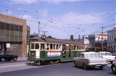
Slide - 35mm slide/s - set of 7, Noel Simons, 23/10/1965 12:00:00 AM
Set of 7 Kodachrome transparencies taken on 23/10/1965 in Melbourne. 1179.1 - W2 488 (route 42, Mont Albert) at the corner of High St. and Cotham Road Kew. Taken from Kew Post Office, has Bank of New South Wales in the background, CBC bank and the Greyhound Hotel. Tram has ads for Kolotex stockings and Ryco oil filters. 1179.2 - SW2 436, in bound (route 45, City) leaving Cotham Road, about to join High St, Kew. Buildings on the south side of Cotham Road in photo. Tram has an ad along with others for Vincent's powders. 1179.3 - W2 545 (route 48, North Balwyn) in High St. Kew. Has Commercial bank in background along with other shops. 1179.4 - W2 648 (route 42, Mont Albert) turning from High St. South into High St at Kew Junction, with Clifton Hotel in background. Tram has an ad for Kenric clothes. Note an MFBB street fire alarm by the tram stop. 1179.5 - W2 566 (inbound route 42, City) at same location as 1179.5. Tram has a Jex and a Remy Martin Brandy ads. on front dash panel. 1179.6 - W2 572 entering Victoria Parade from Brunswick St. Fitzroy. Tram has a Jex and a Remy Martin Brandy ads. on front dash panel. Eastern Hill Fire Station and ICI building in background. 1179.7 - W2 378 (inbound, route 45, City) and W2 572, inbound, in Victoria Parade between Brunswick St and Gismo St. East Melbourne. Otherwise as for 1179.6.All have date stamp of "23 Oct 1965" in purple ink. All black ink unless otherwise noted. 1179.1 - "W2 488 Entering Cotham Rd. from High St. Kew" 1179.2 - "SW2 436 in Cotham Rd., Kew, about to enter High St." 1179.3 - "W2 545 in High Street Kew, nearly opposite Cotham Road" 1179.4 - "W2 648 entering High Street from High Street South, Kew". 1179.5 - "W2 566 entering High St. South from High St. Kew" 1179.6 - "W2 572 entering Victoria Pde from Brunswick St. East Melbourne" 1179.7 - "W2 378 and 572 in Victoria Pde between Brunswick and Gisborne Sts. East Melbourne."tramways, trams, kew, high st kew, cotham road, victoria parade, melbourne, tram 545, tram 488, tram 436, tram 648, tram 566, tram 572, tram 378 -
 Kew Historical Society Inc
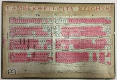
Plan - Subdivision Plan, Jas R Mathers Son & McMillan, Camberwell City Heights, 1922
"Following the 1919 amalgamation of suburban tramway trusts, an electrified tram service extended along Doncaster Road. Housing estates such as the 1919 Balwyn Park Estate, 1922 Hillcrest Estate and the Camberwell City Heights Estate, also 1922, quickly followed. These estates were built over by expansive suburban villas, set in fine gardens and along tree-lined streets. North Balwyn, largely constructed since 1933, was typified by even grander houses, many of them in the 'ocean liner' style and seen at their most distinctive in the Riverview Estate." (Source; 'Balwyn' in eMelbourne)Portions of subdivision plan mounted on both sides of cardboard sheet. Coloured pink, probably to show allotments sold. Area covered: Doncaster Road, Mountainview Road, Panoramic Road, Cityview Road, Longview Road, Riverview Road, Hillview Road, Bulleen Road. Includes location diagram showing railway lines and existing and proposed tram routes.Cardboard backing has advertisement for "Tillock's soluble coffee"subdivision plans -- camberwell (vic.), camberwell city heights subdivision -
 Kew Historical Society Inc
Map, Real Estate Map of Bulleen, Templestowe, Lower Templestowe, Doncaster, North Balwyn
A large undated printed map of Bulleen, Templestowe, Lower Templestowe, Doncaster, North Balwyn showing major and minor roads, waterways and proposed facilities in this area of Melbourne.A useful if undated real estate map that allows viewers to compare current and historic aspects of these areasMap of Bulleen, Templestowe, Lower Templestowe, Doncaster, North Balwyn used by JB Thomson & Co, Real Estate Agents, to identify and record land sales on these. There are some markings on the plan indicating the location and price of lots.subdivision plans, bulleen, templestowe, lower templestowe, doncaster, north balwyn -
 Kew Historical Society Inc
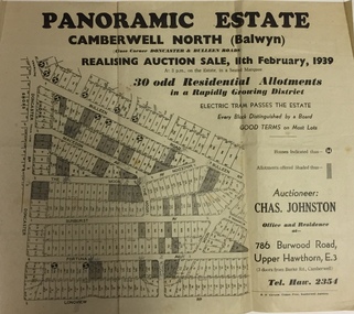
Plan - Subdivision Plan, Panoramic Estate, Camberwell North (Balwyn), 1939, 1939
Subdivision plan advertised as the Panoramic Estate, Balwyn, showing lots for sale in the following streets: Bulleen Road, Macedon Avenue, The Moor, Sunburst Avenue, Doncaster Road, Fortuna Avenue, Longview Road, The Nook, and Touring Avenue.Single page subdivision plan of the Panoramic Estate in Camberwell North (Balwyn); offered for sale in 1939Nilsubdivision plans - balwyn (vic), panoramic estate - camberwell north - balwyn (vic) -
 Kew Historical Society Inc
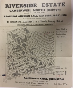
Plan - Subdivision Plan, Riverside Estate, Camberwell North (Balwyn), 1938, 1939
This subdivision known as the Riverside Estate wa sone of the largest and most significant in Balwyn's history.Subdivision Plan for 41 lots within the wider Riverside Estate in Camberwell North, now Balwyn, in February 1938. The auction featured lots in Burke Road, The Boulevard, Mt View Road, Wattle Avenue, Kyora Parade, Cascade Street, Riverside Avenue, Walbundry Avenue, Inverness Way, Bulleen Road and Doncaster Road.Allotments for sale are shaded grey on the map. Certain lots have an H in a circle. These are presumably where houses had already been constructed.subdivision plans - balwyn (vic), riverside estate - balwyn (vic) -
 Kew Historical Society Inc
Award, Boroondara Bowls Competition, Kew Heights BC : Team 4's & Team Triples Trophy, 2013
Sports Clubs in Kew in the final decades of the 19th century and in the early 20th century were often umbrella organisations with facilities for a number of sports. Typically in Kew, this included teams in lawn bowls, tennis and croquet. The Kew Bowling Club was formed in 1880 while the privately owned Auburn Heights Recreation Club was opened in 1904. By 1998, the two Clubs decided to amalgamate at the Auburn Heights site in Barkers Road, forming the Kew Heights Sports Club. The combined club was itself taken over by the Melbourne Cricket Club in 2012 becoming MCC Kew Sports Club. In 2017 MCC Kew closed and its landholding was subsequently sold to Carey Baptist Grammar School. Both the Kew and Auburn Heights Clubs assembled important collections. These historically significant and large collections were donated to the Society in 2020. The collections include manuscripts, pictures, trophies, plans, honour boards etc. References Barnard FGA 1910, 'Sports and Pastimes' in Jubilee History of Kew Victoria: Its origin & progress 1803-1910Reeve S 2012, City of Boroondara: Thematic Environmental History, p.216.The combined collections of the four sporting clubs making up the collection number hundreds of items that are historically significant locally. They are also significant to the sporting history of the greater Melbourne area and to the sports of lawn bowls and tennis in Australia in the 19th and 20th centuries. The collection illuminates two of the Victorian historic themes - 'Building community life' through forming community organisations and 'Shaping cultural and creative life' by participating in sport and recreation.Triangular engraved glass trophy set in a V-shaped metal bracket on a wooden stand, awarded to Kew Heights Bowling Club in 2013. The names of the Team 4's and the Team Triples are engraved on the base of the trophy.BOROONDARA BOWLS COMPETITION / WINNER 2013 / HOSTED BY NORTH BALWYN BCkew heights sports club - barkers road - kew (vic), kew heights men's bowling club -
 Kew Historical Society Inc
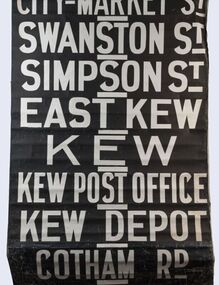
Functional object - Destination Roll, Melbourne & Metropolitan Tramways Board, 1960s
In an era predating the computerisation of equipment on public transport, where trams in Melbourne were driven by drivers and conductors sold fares, destinations were shown at the front and rear of the tram within a glazed box. A driver adjusted the roll to select each new trip destination. Given the length of rolls, in this case approximately nine metres, this could be a time consuming process. In addition to the named destination roll, each tram included a separate roll listing the route numbers.The roll was purchased at a Leski Auction in Armadale as part of a large group of tramways memorabilia including tram 'rolls' from New South Wales, Victoria, South Australia and Tasmania. The auction house described the collection as "The collection of destination blinds or rolls that forms the core of the Railways Trams & Buses Section (Lots 655 – 732) is the best we have ever offered and represents a life-time of collecting by an Adelaide enthusiast, now deceased." Melbourne & Metropolitan Tramways Board Tramways Destination Roll. Black and white paint on linen roll. Forty-eight named destinations including four depots - Camberwell, Hanna Street, Hawthorn, Kew. Multiple destinations in what is now the City of Boroondara (Kew, Hawthorn and Camberwell); including East Kew, Kew, Kew Post Office, Kew Depot, and Cotham Road.Named destinations beginning to end: “Olympic Park / Special / Football / Racecourse / Richmond / Burnley / Riversdale / Wattle Park - Warragul Rd / Wattle Park - Elgar Rd / City / Burwood / Hartwell / Bowen St / Camberwell Depot / Camberwell Jucn / Leura Grove / Gardener / Glenferrie Rd / Chapel St / St Kilda Rd / Camberwell / City / Lonsdale St / University / City via William St / Domain Rd / Hanna St Depot / South Melb & St Kilda Beach / Prahran / North Richmond / Windsor / Hawthorn Depot / Hawthorn / Spencer St / Toorak Rd / Swan & Church St Cnr / North Balwyn / City Flinders & Spencer Sts Corner / City - Market St / Swanston St / Simpson St / East Kew / Kew / Kew Post Office / Kew Depot / Cotham Rd / Malv Tn Hall"melbourne & metropolitan tramways board -
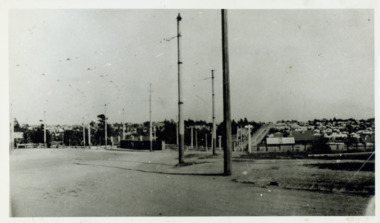 Kew Historical Society Inc
Photograph - Looking towards Kew from Strathalbyn Street and High Street, c.1916
An electrified tram route from Melbourne along High Street replaced an original Horse Tram that terminated at the Kew Cemetery. This new tram only reached the bridge over the Outer Circle railway at the Harp Junction. The line was later extended to North Balwyn.Black and white print positive showing the view west along High Street, Kew (formerly Bulleen Road). In the centre distance is the Boroondara General (Kew) Cemetery. In the foreground, the road crosses the Outer Circle railway. The photograph reflects the level of urbanisation in Kew during the First World War. "Looking towards Kew from Strathalbyn St / High St corner, about 1916. Courtesy Mrs E Bennett, Kew East / Property of Miss Foley"trams -- kew, trams -- kew east, mmtb, m&mtb, tramways, harp junction