Showing 504 items
matching bushland
-
 Stawell Historical Society Inc
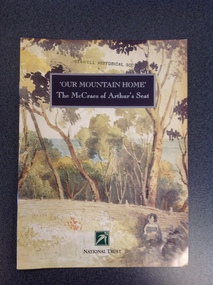
Book, National Trust, Our Mountain Home - The McCreas of Arthurs Seat, January 1996
Cardboard Cover: with a watercolour painting of bushland with a figure in foreground to the right. Picture Painted by Georgina McCrae . at the top is a black rectangle with White writing at the bottom is a logo in green below which is "National Trust in Black PrintAt The top Over a Black Background in white print 'Our Mountain Home' 'The McCraes of Arthur's Seat'. Ath the Bottom in Black Print "National Trust"stawell, victorian history, journal -
 Surrey Hills Historical Society Collection
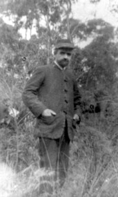
Photograph, Unidentified man possibly at "Terreglea" in Warrigal Road, Surrey Hills
Thought to be taken at "Terreglea" in Warrigal Road circa 1900. Maybe related to the Dodgshun family.A black and white photograph of a man standing in bushland. He is wearing a coat that has toggle-like closures down the front (instead of buttons). He is also wearing a cap and has his hands in his pockets.clothing and dress, warrigal road, surrey hills, terreglea, house names -
 Lakes Entrance Regional Historical Society (operating as Lakes Entrance History Centre & Museum)
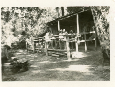
Photograph - Comer's tearoom, 1940c
Also an enlarged copy in brown tones 10 x 15.5Black and white photograph of Mrs Comer's rustic Tea Rooms on the North Arm. It shows a rough bush construction, outside seating and tables, surrounded by bushland. Group of tourists seated at tables. Lakes Entrance Victoriatearoom, tourism -
 Greensborough Historical Society
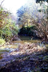
Slide - Photograph, John Ramsdale, Plenty River behind football ground: Slide 51, 1990s
Photograph shows a river and bushland. This is the Plenty River behind the football ground in Greensborough.Part of the John Ramsdale collection of slides and audio visual material.Colour photograph scanned from slide.No maker's marks. Caption on slide "Plenty"plenty river greensborough, plenty river -
 Glenelg Shire Council Cultural Collection
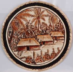
Painting - Painting on cloth - Tongan Tapa Cloth, n.d
Clircular tapa cloth painted and sewn to a round wooden frame. View of a village painted on front of cloth, depicting a pole and wire fence with palnts at base, and palm trees and bushland in the background. The huts have thatched roofs.Front: Tonga Friendly Islands (lower centre, black dye) -
 Lakes Entrance Regional Historical Society (operating as Lakes Entrance History Centre & Museum)
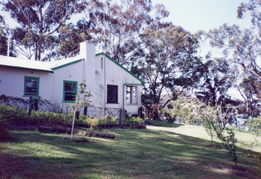
Photograph - Housing, 1999
Land became freehold, purchased by Jack Phillips.Colour photograph of a white painted brick residence with corrugated iron roof, sash windows, Set in bushland overlooking Lake Tyers, built on the site of the Mill Point saw mill at Mill Point Toorloo Arm Victoriahouses, heritage study -
 Wodonga & District Historical Society Inc
Photograph - Photo - Felltimber Creek Road, Wodonga, Neil Coles, July 1984
Felltimber Creek Road is on the south-eastern edge of West Wodonga. It was originally covered in bushlandA large black and white image of cows grazing in a paddock. Image is in a metal and glass frame.felltimber creek, wodonga 1980s, wodonga scenes -
 Greensborough Historical Society
Slide - Photograph, John Ramsdale, Prickly pear, Greensborough: Slide 82, 1990s
Photograph shows prickly pear in bushland near Greensborough. This demonstrates a lack of land care management.Part of the John Ramsdale collection of slides and audio visual material.Colour photograph scanned from slide.No maker's marks. No caption on slide.prickly pear, weeds, land management -
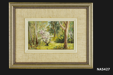 Whitehorse Historical Society Inc.
Painting - Oil Painting in frame (one of a set of 4), Yarran Dheren '88, 1988
Painting of Yarran Dheren Reserve, Mitcham by Whitehorse Historical Society member, Barbara Rogalski. One of a set of 4 paintings.Small oil painting of bushland with bush of pink & white blossom in foreground. Mounted in beige cotton fabric with inner beige plastic frame. Outer frame of brown wood with gold trim. Yarran Dheren Reserve is located in Mitcham.Yarran Dheren '88 Barbara Rogalski.painting, yarran dheren, barbara rogalski -
 Lakes Entrance Regional Historical Society (operating as Lakes Entrance History Centre & Museum)
Photograph, H D Bulmer, 1904 c
Sepia toned photograph of a bark house in bushland with glazed sash windows of six panes upper and lower. Large chimney of dropped slabs held in place by narrow uprights. Known as Northropes Bunga Haven Lake Bunga Victoriabuildings, settlers -
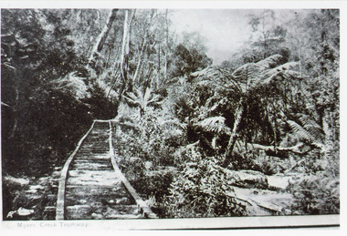 Lakes Entrance Regional Historical Society (operating as Lakes Entrance History Centre & Museum)
Photograph - Tramline, 1925
Rock obtained for works at the Entrance and around Gippsland Lakes.Black and white photograph of a tramway through bushland, steep bank above tramline, tree fern gully below. Tramway connected quarry to landing on Mississippi Creek, Colquhoun Forest north of Lakes Entrance. East Gippsland VictoriaMyer's Creek Tramwayvegetation, transport, room display -
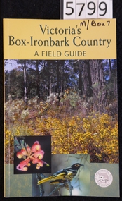 Stawell Historical Society Inc
Book, Malcolm & Jane Caulder, Victoria’s Box Iron Bark Country - A Field Guide, 2002
This is the definitive guide to the Box-Ironbark forests of Central and North-East Victoria First published in 1994 as The Forgotten Forests. By the Victorian National Parks Association Ltd.Cardboard cover with yellow band at top containing Title in green print, below which are 3 colour photographs one showing bushland, one showing closeup of a flower, the other showing a bird. Logo for the Victorian National ParksVictoria's Box-Ironbark Country. A Field Guide Autographed by Ian McCann (Photographer)stawell -
 Greensborough Historical Society
Slide - Photograph, John Ramsdale, Poorly managed farmland: Slide 121, 1990s
Photograph shows a post and wire fence with bushland beyond, and example of poorly managed farmland, thistles in foreground.Part of the John Ramsdale collection of slides and audio visual material.Colour photograph scanned from slide.No caption. Printed maker's mark on slide "Kodak Kodachrome Slide"weeds, farming -
Glenelg Shire Council Cultural Collection
Print - Contact Print - SS Eumeralla; Pastoral Scene, n.d
Sheet of 3 pairs of stereoscopic contact prints from glass plate negatives. Top: Foredeck SS 'Eumeralla' Middle: Two men sitting/standing on tree branch over water. Bottom: Bushland, stream running under bridge. -
 Wangaratta High School
WHS Art, 1986
Landscape painting of an Australian country road with horses and carriages, with a bushland background, in a brown wooden frame. Awarded to Wangaratta High School-Goulburn north east region, by the Australian Natives' Association for the most improved school gardens and grounds in 1986 -
 Bendigo Historical Society Inc.
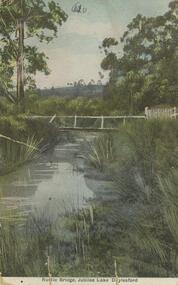
Postcard - Alice McGregor Postcard Collection, 1900 - 1920
Alice McGREGOR Born: 1908; unknown parents. Possibly adopted by the Salter family? Electoral Roll 1936: Highland Terrace Kangaroo Flat. Alice Mary Salter and William Robert Salter living together; presumed to be sister and brother. William Robert Salter was killed in a MVA in Bendigo in 1937 aged 26. In Victoria in 1938, Alice Mary Salter married James Thomas McGregor (born Victoria 1917, died Victoria 1983, buried Fawkner Cemetery) Lived: 1968; 22 Wade Street Golden Square Alice McGregor Died: 1999 aged 91 at Anne Caudle Centre, Bendigo Buried: Kangaroo Flat Cemetery See additional research. Postcard Album of Alice McGregor contained 86 post cards.Postcard Album of Alice McGregor containing 86 post cards. See 1400. Colour photo of a rustic bridge at Jubilee Lake, Daylesford, Victoria Stream running through bushland setting. PO stamp dated Dec 27, 1905 Addressed to Miss Stapleton, Arcade, Bendigo Sender unknown postcard, collector, alice mcgregor -
 Stawell Historical Society Inc
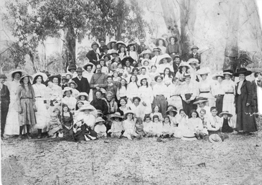
Photograph, Salvation Army Sunday School Picnic 1911 -- 2 Photos
Two Salvation Army Sunday School Picnic photographs showing groups of people in bushland setting. 1911-1912.Two sepia photographs of large groups of people in a bush setting. Also two enlarged copies.Picnic at Stawell 1911 or 12. When Jack & Emma were the Officers at Stawell.stawell religion -
Lakes Entrance Regional Historical Society (operating as Lakes Entrance History Centre & Museum)
Photograph, 2000 c
Also another colour photograph of a man collecting seeds from grass in bushland coastal banksia in background 04699.1Colour photograph of eleven people believed to be Friends of the Environment seated around a picnic table in what appears to be Lions Park Eastern Beach Lakes Entrance Victoriaenvironment, politics, conservation -
 Orbost & District Historical Society
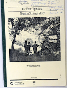
book / document, Far East Gippsland Tourism Strategy Oct 1987, October 1987
The project team for this document comprised E. Beacham, T. Claridge, B. Ebbs, C. Wilso. and J. Cristofaro.This booklet is a useful refernce tool.A document of 86 pp, titled Far East Gippsland Tourism Strategy Study Interim Report October 1987. it has a cream cover and black binding with a b/w photograph of four people in a bushland setting. It contains fold-out maps.tourism-east-gippsland -
 Bendigo Historical Society Inc.
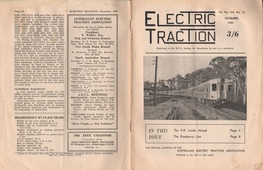
Document - BASIL MILLER COLLECTION: TRAMS - JOURNAL 'ELECTRIC TRACTION', December 1964
Journal of Australian Electric Traction Association, Volume XIX, No. 12. December 1964, 16 pages. History of document: Part of 'Basil Miller. Cover picture shows a ten car interurban set in a bushland setting at Beecroft in the Sydney suburban area.Pub: Australian Electric Traction Asscn. Printer: O'Loughlin Bros. Pty. Ltd., Sydney NSWdocument -
 Orbost & District Historical Society
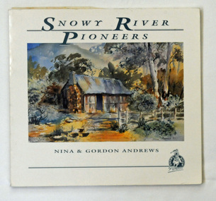
book, Andrews, Gordon, Snowy River Pioneers, 1990
This book was produced by Gordon and Nina Andrews of Netherbyre in Orbost.This is a locally created book. It helps to tell the story of who the Snowy River pioneers and therefore how we came to settle here. It is a useful research tool and is significant to the history of the Orbost area.A 47pp soft covered book titled, Snowy River Pioneers, by Gordon and Nina Andrews, On the front cover is a coloured painting of a hut in bushland. It contains Charles West and other selected stories. The text is by Gordon Andrews. The artwork is by Nina Andrews and Vere Moon.Copyright 1990 Gordon & Nina Andrews Netherbyre, Orbost 3888snowy-river-pioneer stockmen -
Glenelg Shire Council Cultural Collection
Print - Contact Print - Wattle Creek Pastoral Scene, 1960-1979
Sheet of 2 black and white contact prints from glass plate negatives. Top: River/Creek ? Wattle Creek running thru reeds and bushland. Bottom: Bridge across Wattle Creek from beach. Botanic Gardens on right, Kingsley in background. -
 National Vietnam Veterans Museum (NVVM)
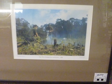
Photograph, Task Force Headquarters Construction. 1966, 1966
Colour photographic print in Black frame and mushroom Brown Mat. Picture Depicts the clearing of space for headquarters construction. One man using a jackhammer on rock while another sits with rifle beside him. Back ground is bush/ forest and cleared bushland.My Vietnam Collection. Task force headquaters construction - 1966 Peter Fischer. On back - Gift horse gallery / fine art original works by local and interstate artists. Professional picture Framers. CNR Paxton st & 130 Main North Rd. Clare 5453. Phone / Fax / Mob.photograph -
 Greensborough Historical Society
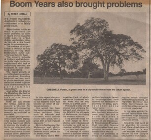
Newspaper Clipping - Digital Image, Diamond Valley News, Greswell Park - Boom years also brought problems, 1987, 16/06/1987
Written in 1987, this article discusses urban sprawl and its effect on agricultural and bushland areas. The photograph is of Greswell Forest, an area under threat.Digital copy of newspaper clipping, black text and image.urban sprawl, greswell forest -
 Greensborough Historical Society
Newspaper Clipping, Diamond Valley Leader, Division on phone towers, 04/10/2017
Residents living near bushland off Mayona Road in Montmorency could soon have a giant mobile phone tower built in their neighbourhood.News article 1 page, black text.montmorency, mobile phones, mayona road montmorency, phone towers -
 Stawell Historical Society Inc
Photograph, Mr Peter Borella standing beside the horse with cart transporting timber with family seated on the timber c1900
Bushland Scene taken in the Grampians Area. Peter Borella standing beside the horse with cart transporting timber with family seated on load. C1900stawell -
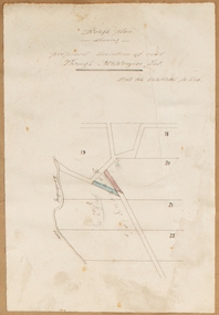 Bacchus Marsh & District Historical Society
Map, Rough plan showing proposed deviation of road through McKenzie's Flat
The date of this map or plan is uncertain. McKenzie's Flat is a bushland picnic area on the Lerderderg River in the Lerderderg State Park close to Bacchus Marsh. Single page map showing a proposed deviation of the road near the McKenzie's Flat area close to Bacchus Marsh. The proposed deviation is shaded in pink, The existing road section to be replaced is shaded in blue. No scale is indicated. Part of a set of maps which are pasted into a bound volume containing 76 maps or plans in total. High resolution digital image stored on BMDHS computer network. mckenzies flat bacchus marsh, bacchus marsh roads and streets -
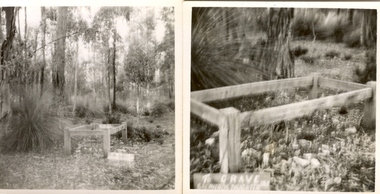 Federation University Historical Collection
Photograph - Pho, Keith Rash, Grave of a Shepherd's Daughter, Lal Lal, c1951
Mary Ann Paterson, the daughter of William Paterson, died in 1863.Two small black and white photographs showing a timber enclosure built around the grave of Mary Ann Paterson at Lal Lal. .1) Shows the grave in the bushland context. A grasstree grows on the left hand side. .2 Out of focus photographic detail of the grave. .1) Verso "Grave of Mary Ann Paterson "The Sheperd's daughter" Lal Lal. Died1850-1964" .2 Verso "Grave of the Shepherds Daughter Died 1850s 60s Lal Lal Mary Ann Paterson aged"lal lal, grave, burial, child, paterson, mary ann paterson, shepherd, shepherd's daughter's grave, lone grave, shepherd's grave -
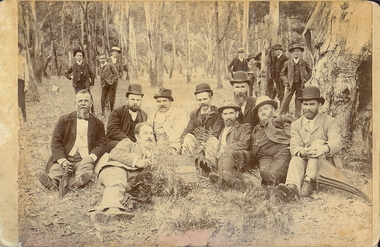 Bendigo Historical Society Inc.
Photograph - PICNIC GROUP OF MEN SITTING IN BUSH SETTING, 1890's
Sepia on cream board, male picnic group in bushland setting. Posed around wicker basket in centre. Base of large tree on RHS. 2 men with umbrellas. 9 young males in background. Dog running away in L upper half. Sepia photograph.person, group, picnic group -
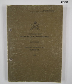 Bendigo Military Museum
Manual - MANUAL OF LAND WARFARE, SURVIVAL, Aust. Army, 1986
Item in the collection re Craig Triffett, See Cat 5997.5 for his service details.This is a small soft cover booklet. Colour is a mottled drab olive. Printing is in black ink. Aust Army crest is in centre top. Inside are seven chapters on how to survive in Aust bushland. How to find water. First Aid. How to start a fire. Text and drawings.booklet, aust army, survival book