Showing 12454 items
matching caulfield-dandenong
-
 Mt Dandenong & District Historical Society Inc.
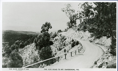
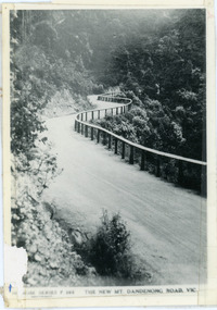
Photograph, The New Road to Mt. Dandenong Vic. c1935, c1935
Rose Series Postcard number 332c1935. Enlarged for display from Rose postcard 'New Road' (Mt. Dandenong Tourist Road). Completed by 1930 but no bitumen as yet. Road not wider and rail along outer edge.kalorama, rose series, mt. dandenong tourist road -
 Glen Eira Historical Society
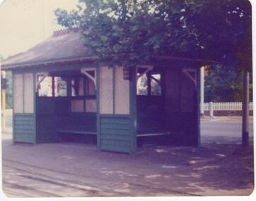
Article - Tram Shelter, Dandenong Road
National Trust of Australia, Victoria, report giving details of tram shelters on the tramways routes of Melbourne; history of cable car system and reasons for tramways amalgamations, includes architectural plan, map and photocopies of two photographs before restoration 1994. Includes bibliography. Two coloured photographs of tram shelter Dandenong Road opposite Hawthorn Road taken in 1978. Detailed history from the Trust News 2000 on history of Melbourne Tram Shelters, various architectural design features, where erected and who design by.dandenong road, hawthorn road, north caulfield, glen eira, flannagan l.s., prahran and malvern tramways trust, street furniture, tram shelters, edwardian style, architectural features, glenhuntly road, caulfield, orrong road, balaclava road, watson stephen, storey rohan, ward andrew -
 Glen Eira Historical Society
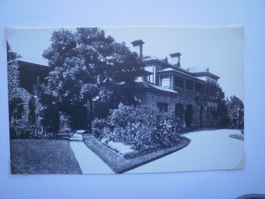
Document - Cobrilla
A one page, undated, unattributed, handwritten transcription of an article in “The Australasian” of 02/03/1912 describing the house Cobrilla on the corner of Dandenong Road and Alma Road. Cobrilla was to be auctioned on 18/03/1912. The file also includes three black and white photographs (86mm x 140mm) of the interior of Cobrilla accompanied by a copy of the photograph and handwritten descriptions. Also included is one black and white photograph (86mm x 140mm) of the exterior of Cobrilla accompanied by a handwritten description and a larger version of the same photograph (253mm x 202mm).cobrilla, dandenong road, alma road, caulfield north, connell ernest h, mansions, architectural features -
 Glen Eira Historical Society
Letter - Caulfield Fire Station, No 26, Tree Reserve, Dandenong Road
A two page photocopy of a handwritten list of property owners and property widths in Dandenong Road between Tooronga Road and Burke Road, dated 23/08/1894 prepared by E Yeatman for F G Wood. The file also includes a one page photocopy of a handwritten letter dated 04/09/1894 from F G Wood to the Fire Brigade Board, Melbourne consenting to the erection of a fire station on Tree Reserve. The file also includes a two page photocopy of handwritten, undated, unattributed illegible notes.wood fred geo, fire brigade board melbourne, dandenong road, derby road, heywood john g, federal building society, tree reserve, caulfield east, catani charles, delves mrs h, giles john, newing w j, cadden robert, forster e, masters j, jenkins j, fire stations, yeatman e -
 Whitehorse Historical Society Inc.
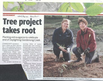
Article, Daylighting Dandenong Creek, 2018
Melbourne Water completed its $14.5 million Daylighting Dandenong Creek project which involved removing 830m of underground pipe.Melbourne Water completed its $14.5 million Daylighting Dandenong Creek project which involved removing 830m of underground pipe. Members of the local community engaged to tree planting the area.Melbourne Water completed its $14.5 million Daylighting Dandenong Creek project which involved removing 830m of underground pipe. melbourne water, bush care, heathmont, dandenong creek -
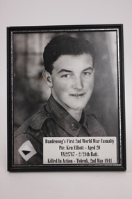 Dandenong/Cranbourne RSL Sub Branch
Photograph - Framed Photo of soldier, Dandenong First 2nd World War Casualty
First Dandenong Boy killed in actionGood Condition.Black framePte.Ken Elliott. Age 20 VX222787 ___ 2/24th. Batt. Killed in Action___Tobruk, 2nd May. 1941 -
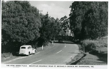 Mt Dandenong & District Historical Society Inc.
Photograph, Mountain Highway Near St. Michael's Church, Mt. Dandenong, Vic, c1950
Rose Series Postcard number 2415Copy of Rose Series post card taken c1950. St. Michael's Foundation Stone laid in 1940. Name 'Mountain Highway" is incorrect as the Mountain Highway was the Sassafras - Basin Road though it may not have received that name by 1950. The correct name is the Mount Dandenong Tourist Road at Mt. Dandenong / Kalorama as Falls Road is the boundary. Note: Heavy roadside vegetation, no white lines at side of road. White car probably pre war Vauxhall.kalorama, mount dandenong, rose series, st. michael's church, mt. dandenong tourist road -
 Mt Dandenong & District Historical Society Inc.
Photograph, Post Office and 'Mountjoy', Mt. Dandenong North, 1913
Rose Series post card #182Copy of Rose Series postcard #182 showing Kalorama Gap in 1913. Haystacks in foreground with Mountjoy Guest House and Beulah Tea Rooms/Mt Dandenong North Post Office in centre. This photograph has a detailed inscription on the back handwritten by John Lundy-Clarke in 1974.Kalorama Gap in 1913 The elm trees are in the centre of the picture. One of these is really two as two suckers of the further tree were twisted together by Fred Jeeves in 1898 and grew as one tree. The other was planted in 1880. The shop is the shop of Mrs Eliza Hand and daughter Florence. The closed in far end of the verandah was the Mount Dandenong North Post Office. The large house is “Mountjoy” owned and run by the Jeeves Family from 1908 till 1943. It was built in 1905 by the Paynters who sold to Ellis Jeeves in 1908.He moved his line of coaches from “Kalorama” his old homestead and housed the horses in a line of stables behind “Mountjoy”. Price’s house, which contained their shop, the first one on the mountain, opened 1906, can be seen faintly behind the pine tree opposite the bend in the road, which was the main road then and now is Ridge Road. The Price’s house just shows in two tiny pieces, one on each side of the pine tree half way up. The house to the right of and high up the pine tree is Walker’s cottage which exists today opposite Jack Kidd’s home at the far edge of Lt 2 Village Settlement and was between Main Road and Barbers Road which runs down the left behind the elms. Walker’s homestead can be seen near left edge of picture 2/3 way up. The roof of the Methodist Church shows among trees left of picture. This, like Mrs Hand’s shop was built on portions separated from Isaac Jeeves’ Selection “C” known as Jeeves Saddle. kalorama gap, five ways, mountjoy, john lundy-clarke, beulah tea rooms, post office, fred jeeves, paynter, jeeves, frederick jeeves, price, walker, jack kidd -
 Beechworth Honey Archive
Publication, Kosher Australia food guide: 2008 edition (Kosher Australia Pty. Ltd.), Caulfield North, 2008, 2008
-
 Ringwood and District Historical Society
Photograph, Maroondah Highway East, Ringwood- 1965. Corner of Mt Dandenong Road before widening
Black and white photograph (3 separate images)Typed note on back of photograph: "M'dah Hwy, June 1965, before it was widened from Mt Dandenong on." -
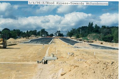 Ringwood and District Historical Society
photograph, Eastlink Ringwood Bypass Construction- Ringwood Bypass-Towards Mt Dandenong 5/4/96
Colour photographWritten on back of photo: "Ringwood Bypass-Looking towards Mt dandenong Road 5/4/96" -
 Dandenong/Cranbourne RSL Sub Branch
Newspaper - Newspaper dated May 21st.May 1941, Local DANDENONG JOURNAL
Photograph donated by Ken,s Brother. Frank Elliott, who also was an ex serviceman later on. Deceased,s father was a member in the 1st. A.I.F., and served again in the Home Defence at Transport Service Headquarters in Sth. Melbourne. Refer also to 0089. (photograph of Pte Ken Elliott) Part of Dandenong,s history.LOCAL NEWS PAPERPaper telling of Dandenong,s first casualty in. 1941. Pte. Ken Elliott. aged 20 years. -
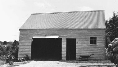 Ringwood and District Historical Society
Photograph, Stables at old Police Station, 32 Mt. Dandenong Rd. built 1888
Black and white photograph of weatherboard structure with iron roof.Written on rear of backing sheet, "Stables at old Police Station, 32 Mt. Dandenong Rd. 1888. -
Glen Eira Historical Society
Pamphlet - Air raid precautions
This file contains two items about air raid instructions during World War 2. 1. Air Raid instructions booklet (15 pages), National Emergency Services of NSW’s official public handbook , produced by Consolidated Press Ltd. 2. City of Caulfield Air Raid Precautions (1 page), cardboard instructions approved by State Emergency Council for Civil Defence, Victoria.world war 1939-1945, emergency services, air raid precautions, air raid sirens, air raid shelters, air raid wardens, caulfield, hawthorn road, packer j. i., tyers s. w. cr., dandenong road, carnegie, briggs james. r. town clerk -
Koorie Heritage Trust
Book, Brown, Rik, The upper Yarra River corridor : sites of conservation significance, 1993
179 p.; maps; appendices; 30 cm.environmental protection -- victoria -- yarra river region. floodplain management -- victoria -- yarra river region. ecology -- victoria -- yarra river region. biodiversity conservation -- victoria -- yarra river region. yarra river region (vic.) -
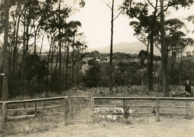 Ringwood and District Historical Society
Photograph, Ringwood: Wooden fence and cyclone gate overlooking Mount Dandenong, Kilsyth and Heathmont, taken from Bedford Road, looking South. (undated), circa 1920
A photograph of a wooden fence with a cyclone gate overlooking Mount Dandenong, Kilsyth and Heathmont. Taken from Bedford Road, looking south. Donated by Mrs Purser and has printer's marks that suggest that the photograph was printed in a newspaper.View over Ringwood -
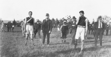 Ringwood and District Historical Society
Photograph, Footballers at Mount Dandenong Road Recreation Ground oval circa 1914
Footballers at Mount Dandenong Road Recreation Ground oval circa 1914. Man in centre with hat and pipe possibly A. J. (Jun) Sugden, headmaster of Wantirna School, and Bob Skerrett on right hand side with hat.Catalogue card reads, "Possible? Man in centre with hat and pipe A. J. (Jun) Sugden, headmaster of Wantirna School. RHS with hat (front) ? Bob Skerrett?" -
 Ringwood and District Historical Society
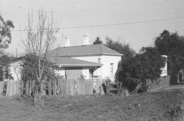
Photograph, Ringwood's first Police Station, 32 Mount Dandenong Road. (note room at left)
Written on back of photograph, "32 Mount Dandenong Road. Ringwood's first Police Station (note room at left). -
 Ringwood and District Historical Society
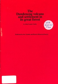
Book, The Dandenong Volcano and Settlement in its Great Forest, 1976
This booklet fits together the geologist's story of the origins of the Dandenong Ranges with the story of settlement on them, from the first tiny group at Harmony Vale, as told in the manuscript "Corrhanwarrabul the Great Forest" in the possession of the Lilydale and District Historical Society. -
 Melbourne Tram Museum
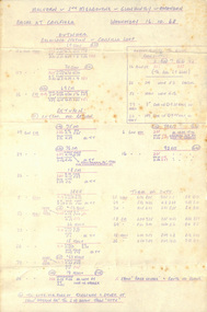
Administrative Record - Table Cards, Melbourne & Metropolitan Tramways Board (MMTB), Table cards - Races at Caulfield, Wednesday 16.10.68, Oct. 1968
1 hand written page of table cards for Caulfield Races for Wednesday 16 October 1968. Page is a spirit duplicated ("roneo") copy for use by Malvern, South Melbourne, Glen Huntley and Essendon depots.trams, tramways, table cards, timetables, caulfield, events, race traffic -
 Ringwood and District Historical Society
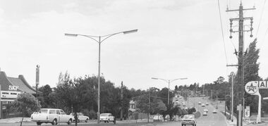
Photograph, Maroondah Highway East, Ringwood- 1971. Looking east towards Mt Dandenong Road
Black and white photographWritten on back of photograph: "Maroondah Highway, looking east towards Mt Dandenong Road turnoff past lake. 1971." -
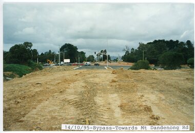 Ringwood and District Historical Society
photograph, Eastlink Ringwood Bypass Construction-Bypass-Towards Mt Dandenong Rd 14/10/95
Colour photographWritten on back of photo: "Bypass From Suda Av Looking Towards Mt Dandenong Rd 14/10/95" -
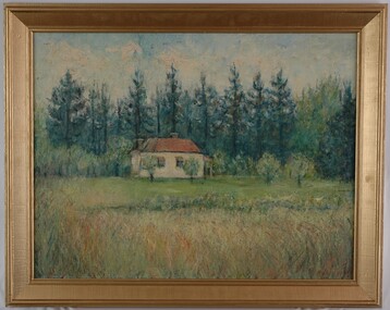 Glenelg Shire Council Cultural Collection
Painting, Jack Freeman, Landscape Dandenong, c. 1961
CEMA Art Collection Winner of Portland Artist's Society Prize 1961The painting depicts a small building set amongst tall trees and grasses. The building is situated in the centre of the work and is cream with a red roof and red awnings. In the foreground is a large area of long grass which leads into the shorter maintained grass that surrounds the building. Behind the building are numerous tall dark green trees. The work has a wide gilded frame and exposed canvas.Front: (No inscriptions) Back: Jack Freeman 1961 Landscape Dandenong (top right, black handwriting) 18 (white sticker) -
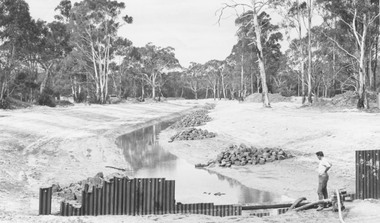 Ringwood and District Historical Society
Photograph, New bridge over Dandenong Creek Wantirna Road Ringwood, being built and creek lined, 1970
Written on back of photograph, "New bridge over Dandenong Creek Wantirna Road being built and creek lined, 1970." -
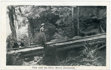 Mt Dandenong & District Historical Society Inc.
Photograph, View near the Falls, Mount Dandenong, early 1900s
Postcard showing a woman wearing a long dress and wide brimmed hat standing on a footbridge that crosses the Olinda Creek. Tree ferns and bushes are in the background. Taken early 1900s.On front of postcard: View near the Falls, Mount Dandenong. On back of post card: Mason, Firth & McCutcheon, Printers, Melbourne.mason, firth & mccutcheon, olinda falls, footbridge, bridge, mt dandenong, olinda creek -
 Ringwood and District Historical Society
Photograph, Looking east along Dandenong Creek from very end of Heatherdale Road, Vermont South, January 1979
Written on back of photograph, "Jan. 79. Looking east along Dandenong Creek from very end of Heatherdale Road." -
 Mt Dandenong & District Historical Society Inc.
Photograph, The New Mt Dandenong Road, Vic
Copy of Rose Series postcard #385 showing the new Mt Dandenong Tourist Road with wooden railing fence on low side of road. Surface not yet made. This photograph has a detailed inscription on the back handwritten by John Lundy-Clarke in 1974.View downhill from the Windy Bend showing the site of the 1972 landslide. In this picture the road is running along the top edge of the wall 900’ thick of Kalorama Docite that plunges thousands of feet deep down into the earth below the Ranges and extends to Fern Tree Gully. It was once a horizontal terrace nearly ten miles square and tipped over to the left when the mountain subsided into its volcanic cauldron.mt dandenong road, rose series, windy bend, landslide -
Ringwood and District Historical Society
Framed photograph, William Cook Pioneer of Ringwood and Mt Dandenong North c 1914
Photo of William Cook who was a pioneer in Ringwood and lived in Mt Dandenong North at one time c.1914.Coloured photograph in wooden frame with buff coloured inset +Additional Keywords: Cook, WilliamBack of frame inscribed William Cook, Pioneer. -
 Ringwood and District Historical Society
Photograph, Whitehorse Road and Mount Dandenong Road, including early electric installation of street lighting. (Undated)
Written on back of photograph, "Whitehorse Road and Mount Dandenong Road". Catalogue card reads, "Early electric installation of street lighting". -
 Ringwood and District Historical Society
Work on paper - Pencil sketch, Artist unknown, initials D.M, Sketch of pottery kilns at East Ringwood, corner of Velma Grove and Mount Dandenong Road (Oxford Road). Kilns shut down in 1926, c.1926
Sketch of the four pottery kilns at East Ringwood, corner of Velma Grove and Mount Dandenong Road (Oxford Road). The kilns shut down in 1926. Judging by the handwriting, the artist and author appears to be John Rodaughan, East Ringwood historian, whose other works include history on Burnt Bridge Hotel and other parts of East Ringwood. The back of the sketch includes a rough hand-drawn map, that appears to be of the insulator works area, between Mt Dandenong Road and Evon Avenue. The timeline includes generic milestones in blue ink and those associated with Ringwood in red writing.Kilns; D.M.