Showing 196 items
matching deep mines
-
 Bendigo Historical Society Inc.
Document - Preservation proposal
... already owned the adjacent Fortuna Mine, and through deeper mining... already owned the adjacent Fortuna Mine, and through deeper mining ...Fortuna Villa was initially commenced as a modest single storey home in 1861 next to the 180 Mine by Theodore Ballerstedt, who sold the mine and house to George Lansell in 1869. Lansell already owned the adjacent Fortuna Mine, and through deeper mining techniques greatly expanded the mine's operation, his personal wealth, and the house and grounds. Lansell was soon known as the 'Quartz King', Australia's first gold mining millionaire and credited as the driving force behind much of Bendigo's prosperity. He continuously added to and expanded the villa, decorating it extravagantly with the finest of artworks and materials, into a sprawling mansion with extensive landscaped grounds, to create a house and grounds of a size and grandeur with few rivals in Australia. After his death in 1907, his second wife Edith carried on with improvements, creating a house and grounds developed over 50 years. The attached mine also contributes to its significance, being one of the richest mines in Bendigo, and at one stage probably the deepest gold mine in the world at 3176 feet. The 1875 crushing works are attached directly to the mansion, and the mine's tailings and settling ponds (turned into ornamental lakes) represent a direct link between George Lansell's wealth and its source. Fortuna was compulsorily acquired by the Commonwealth in 1942 as the Cartographic Headquarters of the Australian Survey Corps during World War II, and many ancillary structures were added while preserving the main house and ornamental grounds. Victorian Heritage Database Report https://vhd.heritagecouncil.vic.gov.au/places/68334/download-reportProposal for the formation of a Fortuna Commission to ensure the preservation of Fortuna Villa. Written by Daryl McClure. May 2012fortuna villa, preservation, daryl mcclure -
 Stawell Historical Society Inc
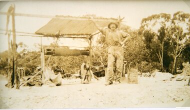
Photograph, Mr Joseph Mitchell with his mine at Campbells Gardens Deep Lead
... Mr Joseph Mitchell with his mine at Campbells Gardens Deep...Joseph Mitchell with his mine at Campbells Gardens Deep... grampians Joseph Mitchell with his mine at Campbells Gardens Deep ...Joseph Mitchell with his mine at Campbells Gardens Deep Leadstawell deep lead -
 Stawell Historical Society Inc
Archive - CD/DVD, Stawell Historical Society 08 Gregs Mine - Stawell Historical Society Christman Breakup 2008 at Cox's Farm. Greg Camerons Mine at Deep Lead, 2008
... Camerons Mine at Deep Lead.... Camerons Mine at Deep Lead. Archive CD/DVD ...stawell -
Tarnagulla History Archive
Set of Maps (Mining & Local Area), various
David Gordon Collection. A set of mining documents, maps and plans: 1. Dunolly Deep Leads - showing location and names of deep lead gold deposits in region around Dunolly including at Tarnagulla and Newbridge. Geological Survey of Victoria, Department of Minerals and Energy. Bulletin No. 62, Map No. 4 Dunolly (770 x 485 mm). 2. Poseidon Lead (Facsimile) 3. Nick O Time Lead (Facsimile) 4. Happy Go Lucky Mine prospectus and plan (colour copy) 5. Jones Creek GM Co. (Raven & Gourlay's) Waanyarra - Prospectus (colour copy) 6. Poseidon Area Plan (colour copy) and Poseidon Area map (B&W copy). 7. Cross-section diagram of Spread Eagle Reef 8. New Birthday Gold Mine - area map (colour copy) and mine cross-section ( (colour copy). 9. Cross section of Poverty Reef, by Department of Mines (B&W copy, 2 parts on A2 paper) 10. Time-Lease Graph for Watts Reef, Specimen Reef, Stony Reef, Poverty Reef (second page in detail), created by Eric WIlkinson for Ref Mining NL, 1995 11. 1859 Plan of the Gold Workings & Township of Sandy Creek, Shewing the Mining Leases, Extended Claims & Machinery by R.J. McMillan, Mining Surveyor (B&W copy) 12. Longitundinal and Transverse Vertical Sections of Poverty Reef, Sandy Creek 1859, by R.J. McMillan, Mining Surveyor (B&W copy) 13. Tarnagulla Locality Plan (B&W copy) 14. Universal Grid Reference Map (Topographic) for Laanecoorie North (2 copies) 15. Universal Grid Reference Map (Topographic) for Inglewood South 16. Poverty Reef, Plan showing shafts and early tenements, created by Eric WIlkinson for Ref Mining NL, 1995 17. Locality Map of mining leases in Tarnagulla 18. Plan and Elevation of part of Poverty Reef, Sandy Creek, showing the claims and positions of the shaft. by R.J. McMillan, Mining Surveyor (Facsimile, composed of taped together components) 19.Plan and Elevation of part of Poverty Reef, Sandy Creek, showing the claims and positions of the shaft. by R.J. McMillan, Mining Surveyor (Facsimile, composed of taped together components) -
 Bendigo Historical Society Inc.
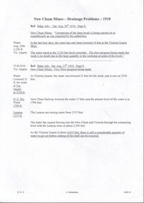
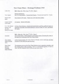
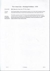
Document - DRAINAGE PROBLEMS - NEW CHUM MINES DRAINAGE PROBLEMS 1910
... Page 8. ''New Chum Mines. Unwatering of the deep levels... Mines Drainage Problems 1910 Bendigo Advertiser 20/8/1910 Page 8 ...Handwritten extract from the Bendigo Advertiser 20/8/1910 Page 8. ''New Chum Mines. Unwatering of the deep levels is being carried on as expeditionsly as was expected by the authorities. In the last four days, the water has only been lowered 14 feet at the Victoria Quartz Mine. The water stood at the 3,226 feet level yesterday. The slow progress being made this week is no doubt due to the large quantity in the workings at some of the levels.'' From the Bendigo Advertiser 27/8/1910 Page 9. ''New Chum Mines. Very slow progress being made. At Victoria Quartz, the water was lowered 32 feet for the week, and is now at 3258 feet. New Chum Railway lowered the water 17 feet and the present level of the water is at 1796 feet. The Lazarus are raising water from 2157 feet. The water has ceased flowing into the New Chum and Victoria through the connecting level with the Lazarus Mine at about 2,500 feet. As the Victoria Quartz is down 4,614 feet, there is still a considerable quantity of water to get out before sinking of the shaft can be resumed.''document, gold, drainage problems, drainage problems, new chum mines drainage problems 1910, bendigo advertiser 20/8/1910 page 8 & 27/8/1910 page 9, new chum mines, victoria quartz, new chum railway, lazarus, new chum and victoria -
 Bendigo Historical Society Inc.
Document - DRAINAGE PROBLEMS - WATER PROBLEMS
Two handwritten pages with extracts from the Bendigo Advertiser Mining Intelligence. Notes mention making arrangements with other mines to resume bailing, Victoria Quartz still shaft sinking despite strong flow of water, Lansell's 180 preparing to bail water from the deep levels, so that the Victoria Quartz may continue shaft sinking and finishing cutting of plat at 4454 ft. Also a weather report on the 14/6/1910. From the Albert Richardson Mining History Collection.gold, drainage problems, drainage problems, water problems, bendigo advertiser mining intelligence 18/4/1910, 9/5/1910, 23/5/1910, 30/5/1910, 6/6/1910, 13/6/1910, victoria quartz, lazarus coy, lansell's 180, albert richardson -
 Bendigo Historical Society Inc.
Document - DRAINAGE PROBLEMS - DRAINAGE PROBLEMS 1910
Handwritten notes from Bendigo Advertiser reports. (1) Mr J. H. Craig reports- Victoria Reef Quartz - Cleaned and tested No 3 boiler. Have bailed 3,905 tanks. Water now 2.953 feet from surface. At Lazarus - Bailed 4,828 tanks. At New Chum Railway - Cleaned and tested boilers and flues, effected repairs to machinery and shaft, and started bailing at 3 pm on Friday 29th inst, and bailed 965 tanks. Bendig Advertiser 3/8/1910 Page 2 Mining Intelligence. (2) New Chum Mines - Better progress is now being made in lowering the water in the deep level workings at the New Chum Mines. At the Victoria Quartz, the water which on Monday stood at 3073feet, has been lowered 70 feet during the past four days. The pumping service at the New Chum Railway was in operation yesterday, and the winding plant is fully occupied. There is a considerable quantity of water toraise, and the companies have a difficult task before them. Bendigo Advertiser 5/8/1910 Page 2. Document from Albert Richardson Collection of mining history.gold, drainage problems, new chum drainage association, new chum mines drainage problems 1910, bendigo advertiser 3/8/1910 page 2, mr j h craig, victoria reef quartz, lazarus, new chum railway, bendigo advertiser 5/8/1910 page 2, albert richardson -
 Bendigo Historical Society Inc.
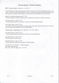
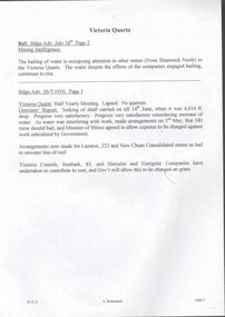
Document - DRAINAGE PROBLEMS - VICTORIA QUARTZ
Handwritten copy of reports from the Bendigo Advertiser regarding water in the mine. (1) The bailing of water is occupying attention in other mines (from Shamrock North) to the Victoria Quartz. The water despite the efforts of the companies engaged bailing, continues to rise. Bendigo Advertiser July 18th Page 3. (2) Victoria Quartz Half Yearly Meeting, Lapsed, No quorum. Directors' Report: Sinking of shaft carried on till 14th June, when it was 4,614 ft. deep. Progress very satisfactory. Progress very satisfactory considering increase of water. As water was interfering with work, made arrangements on 3rd May, that 180 Mine should bail, and Minister of Mines agreed to allow, expense to be charged against work subsidised by Government. Arrangements now made for Lazarus, 222 and New Chum Consolidated mines to bail to unwater line of reef. Victoria Consols, Ironbark, 83, and Hercules and Energetic Companies have undertaken to contribute to cost, and Gov't will allow this to be charged on grant. Document from Albert Richardson Collection of mining history.gold, drainage problems, new chum drainage association, victoria quartz, bendigo advertiserjuly 18th page 2 mining intelligence, bendigo advertiser 20/7/1910 page 3, lazarus, 222, new chum consolidated, victoria consols, ironbark, 83, hercules and energetic, albert richardson -
 Bendigo Historical Society Inc.
Document - DRAINAGE PROBLEMS - NEW CHUM DRAINAGE PROPOSALS
Six pages of handwritten notes regarding the New Chum Drainage Proposals. Extracts from the Bendigo Advertiser mentioning the rising of the water in the New Chum Mines. An Advertiser report 27/12/1910 mentions that deep mining will have to be abandoned owing to the absence of some proper scheme to cope with the water. An arrangement had been made by which the companies affected along the line should contribute to a scheme. Suggestions made that the water be lifted by electric pumps. Baling with tanks had been tried for 6 months and then abandoned. Directors Report Victoria Reef Quartz Jan 1911 mentions unwatering had been carried on with assistance of Government. On the 20th Dec, one rope gave out. Decided that replacing it and doing the necessary work could not be met in the present financial conditions. It was also considered that the costof trying to reach the bottom reefcut in the New Chum Railway could not be continued by baling as its cost proved too expensive, while it could probably be done economically & effectively by electric pump which is now subject to negotiations with the Mining Dept.' At the end of the report is a Balance Sheet. Document from Albert Richardson Collection of mining history.document, gold, drainage problems, drainage problems, new chum drainage proposals, bendigo advertiser 11/1/1911 page 7, victoria quartz, victoria consols, bendigo advertiser 5/7/1910 page 3, mr h v whitelaw, mines dept, insp ross, lansell's 180, 222, new chum consolidated, lazarus, bendigo advertiser 6/7/1910 page 7, 9/7/1910 page 9, drainage troubles, bendigo advertiser 8/7/ page 8, new chum railway, south belle vue, eureka ext'd, bgo adv 25/7 1910, 27/12/1910 page 2, rae's machine, bendigo advertiser 2/1/1911, mr mcbride, mines dept, mr stanfield, mines act, bendigo advertiser 16/1/1911 page 3, victoria reef quartz half yearly meeting 1911, directors report and balance sheet, geo paynting -
 Bendigo Historical Society Inc.
Document - DRAINAGE PROBLEMS - VICTORIA QUARTZ INFLUX OF WATER
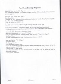
Handwritten copy of a report in the Bendigo Advertiser 12/7/1910 Page 2. New Chum Mines. Progress of Bailing Operations. The bailing operations at the New Chum mines have not yet had the desired effect of lowering the water. On the contrary the water continues to rise in the Victoria Quartz which is the mine most directly affected. It is expected that the necessary preparations at the Lazarus will be completed today when it is hoped that bailing will be commenced at that mine. The success of the bailing scheme will largely depend on the efforts of the Lazarus to cope with the water and the progress made during the next few days will be awaited with interest. It is generally believed that the great volume of water is coming north from the southern group of mines. The companies south of the New Chum Consolidated are not bailing, and the pumping service at the New Chum Railway which is installed down to the 550 ft. level has not been operated since that company abandoned work a few months ago. A perusal of the statistics of the New Chum Drainage Association shows that the pumps at the New Chum Railway were lifting on anaverage close on 1,000,000 galls of water per month in the winter. That great volume of water is now pouring from storage dams at 550 feet to the deep levels, and in the natural order of things will have to be lifted by the tanking system in vogue at the mines N.' Document from Albert Richardson Collection of mining history.document, gold, drainage problems, new chum drainage association, victoria quartz influx of water, bendigo advertiser 12/7/1910 page 2, victoria quartz, lazarus, new chum consolidated, new chum railway, new chum drainage association -
 Bendigo Historical Society Inc.
Document - DRAINAGE PROBLEMS - NEW CHUM LINE DRAINAGE PROBLEMS 1910
Handwritten extract from the Bendigo Advertiser 27/12/1910 Page 2. ''The Victoria Quartz, having deepened its shaft to 4,614 feet, had to abandon sinking on account of an inrush of water from the flooded mines to the south on the line. The influx occurred on the 15th of June, and notwithstanding that baling has been carried on almost constantly the company has failed to get the water out. It appears that the deep ground will have to be abandoned, owing to the absence of some proper scheme to cope with the water.'' Albert Richardson Mining History Collection.document, gold, drainage problems, drainage problems, new chum line drainage problems 1910, bendigo advertiser 27/12/1910 page 2, victoria quartz, albert richardson -
 Bendigo Historical Society Inc.
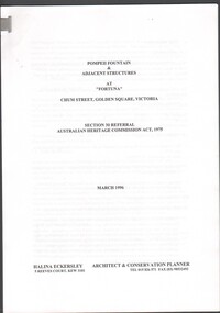
Document - Pompeii Fountain & Adjacent Structures at "Fortuna"
... already owned the adjacent Fortuna Mine, and through deeper mining... already owned the adjacent Fortuna Mine, and through deeper mining ...Fortuna Villa was initially commenced as a modest single storey home in 1861 next to the 180 Mine by Theodore Ballerstedt, who sold the mine and house to George Lansell in 1869. Lansell already owned the adjacent Fortuna Mine, and through deeper mining techniques greatly expanded the mine's operation, his personal wealth, and the house and grounds. Lansell was soon known as the 'Quartz King', Australia's first gold mining millionaire and credited as the driving force behind much of Bendigo's prosperity. He continuously added to and expanded the villa, decorating it extravagantly with the finest of artworks and materials, into a sprawling mansion with extensive landscaped grounds, to create a house and grounds of a size and grandeur with few rivals in Australia. After his death in 1907, his second wife Edith carried on with improvements, creating a house and grounds developed over 50 years. The attached mine also contributes to its significance, being one of the richest mines in Bendigo, and at one stage probably the deepest gold mine in the world at 3176 feet. The 1875 crushing works are attached directly to the mansion, and the mine's tailings and settling ponds (turned into ornamental lakes) represent a direct link between George Lansell's wealth and its source. Fortuna was compulsorily acquired by the Commonwealth in 1942 as the Cartographic Headquarters of the Australian Survey Corps during World War II, and many ancillary structures were added while preserving the main house and ornamental grounds. Victorian Heritage Database Report https://vhd.heritagecouncil.vic.gov.au/places/68334/download-reportConservation report for the Pompeii Fountain & Adjacent Structures at "Fortuna" Chum Street, Golden Square, Victoria. Prepared for Fortuna Historical Committee. March 1996.Halina Eckersley, Architect & Conservation Planner, Kewpompeii fountain, greenhouse, fortuna lake, gardens -
 Federation University Historical Collection
Book, Final recommendations Ballarat Study Area Land Conservation Council, Victoria, 1982, 1982
... australasian deep lead mine... australasian deep lead mine happy valley school piggoreet berringa ...Yellow soft covered report of 95 pages . The contents of the report include: Parks, reference areas, wildlife reserves, water production, harwood production, softwood production, flora Reserves and Flora and Fauna reserves, bushland reserves, historic area and reserves, rivers and streams, Roadside conservation and Highway parks, Education areas and School Plantations, Lake Reserves, geological reserves, recreation, scenic reserves, agriculture, mineral and stone production, utilities and survey, township land, Uncommitted Land, military training, other reserves and public land. Maps include: The Study area 1: 250 000 Supplementary Mapsland conservation authority, ballarat, endowment plantations, pine plantations, langi ghiran state park, mount buangor state park, enfield state park, ballarat-creswick regional park, rossbridge, black lake, flax mill swamp, dereel lagoon, lake bolac, lake wongan, langi ghiran reservoir, gong gong reservoir, pincotts reservoir, beales reservoir, wilsons reservoir, moorabool reservoir, korweinguboora, korweinguborra reservoir, learmonth bores, sago hill, illabarook reservoir, ballarat water commission, dunneworthy, mount cole, mont lonarch, ben major, waterloo, trawalla, linton, ross creek, canadian, shepherds flat, lal lal, mount doran, raglan, chute, carngham, buninyong, watsons hill, enfield, cape clear, illabrook, rokewood junction, mount warrenheip, nerrina, jubilee, golden stream, australasian deep lead mine, happy valley school, piggoreet, berringa, bulldog, ballarat common, wildlife, water, timber, flora, rivers, geology, agriculture, warrenheip, biodiversity -
 Bendigo Historical Society Inc.
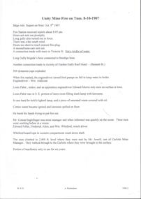
Document - ULSTER GOLD MINING COMPANY NO LIABILITY - UNITY MINE FIRE 8/10/1907 & FAMOUS GOLD MINES
Typed copy of recount by Albert Richardson of a fire at Unity Mine on Tuesday 8-10-1907. Report from the Bendigo Advertiser Wednesday October 9th 1907. Notes mention Fire Brigade, miners, how the fire started and how the men down the shaft escaped when the rope crash down the shaft. On the back is a handwritten carbon copy of notes titled Famous Gold Mines of Bendigo and Eaglehawk. Notes give yields of gold for alluvial and quartz mining. Deep Shafts in 1904 of which there were eleven with a depth of more than 3000 feet and 53 over 2000 feet and two which were more than 4000 feet. Wages for 1911 for Engine Drivers and Firemen and Boiler Attendants. Note on winding plants and air compressors.document, gold, ulster gold mining coy no liability, ulster gold mining company no liability, unity mine fire 8/10/1907, bendigo advertiser 9/10/1907, garden gully reef hotel, wm addicoat, louis pabst, edward morris, conrad inglefinger, edward fuller, frederick allen, wm whitford, mr jewell, carlisle mine, famous gold mines of bendigo and eaglehawk, new chum line, garden gully line, hustlers line, victoria quartz mine, new chum railway, mines report 1911 p15, albert richardson -
 Bendigo Historical Society Inc.
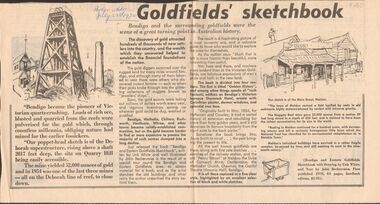
Newspaper - GOLDFIELDS SKETCHBOOK ARTICLE, BENDIGO ADVERTISER, 23rd July 1970
Newspaper article titled' Goldfields' sketchbook. Article on book release ' Bendigo and Eastern Goldfields Sketchbook with Drawings by Unk White and text by John Bechervaise, first published 1970, 64 pages, hardback edition, $1.95. Extract from article ' our poppet-head sketch is of the Deborah superstructure, rising above a shaft 2017 feet deep, the site on Quarry Hill being easily accessible. The mine yielded 52,000 ounces of gold and in 1954 was one of the last three mines all on the Deborah line of reef, to close down'Bendigo Advertiser July 23rd 1970.bendigo, mining, gold discovery, 'bendigo advertiser -
Bendigo Historical Society Inc.
Document - NORTH HUSTLERS - NOTES ON NORTH HUSTLERS
BHS CollectionTwo handwritten notes on the North Hustlers Mine. (a) reads: North Hustlers originally known as New Hustlers. Shaft 450 ft. No gold production. Worked 1940 - 1942. Given by Eric Wilkinson to me, May 1971. (b) reads: Hist. Guide. Rectify - North Hustlers (originally known as New Hustlers. (No Production) should read - No gold produced. Shaft 450 feet deep. Poppet legs recently dismantled.cottage, miners, north hustlers mine, new hustlers, eric wilkinson, hist guide