Showing 3431 items
matching distances
-
 Mission to Seafarers Victoria
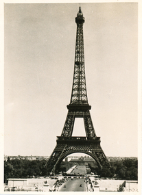
Photograph - Gelatin silver photograph, Allan Charles Quinn, The Eiffel Tower - Paris 6-6-49, 06 June 1949
This photograph is one of a series taken by Allan while travelling through France in mid-1946. There are several letters relating to this journey.This is a photograph from the Allan Charles Quinn collection which is a collection of letters and photograph depicting aspects of life at sea for a young man in the era immediately following World War II.A black and white photograph of the Eiffel Tower, from some distance. There is a narrow white boarder around the image.On reverse: PARIS 6-6-49 handwritten in blue ink. below this is a pencil mark, similar to "ItI"written sideways.allan-quinn, photograph, paris, france, eiffel-tower -
 Flagstaff Hill Maritime Museum and Village
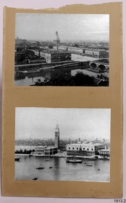
Photograph
Photographs (2) on cardboard 1. Turin with view of Alps in distance 2. Venice The Campanile "Palace of the Doges"flagstaff hill, warrnambool, shipwrecked-coast, flagstaff-hill, flagstaff-hill-maritime-museum, maritime-museum, photographs, turin, venice the campanile, shipwreck-coast, flagstaff-hill-maritime-village, palace of the doges -
 Port Melbourne Historical & Preservation Society
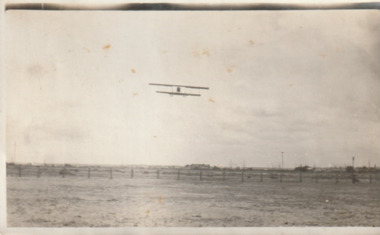
Photograph - Aircraft over the Bend, 1920s
Snapshot of aircraft (probably Graham Carey's) over the Bend. Scattering of buildings can be seen in the distance. 1920s.'Port Melbourne Airport'fishermans bend, transport - aviation and aerodrome, r graham carey -
 Bendigo Historical Society Inc.
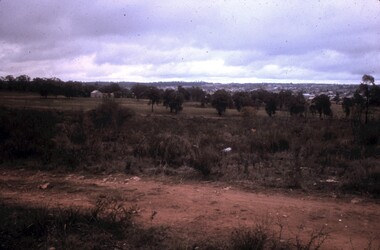
Slide - PETER ELLIS COLLECTION: SLIDE, May 1970 - Jan 1972
Coloured slide transparency. Image is of a dirt road, with a building to the right in the background. Trees are in the background and a town is in the distance.Kodachrome Transparencyslide, bendigo, bendigo institute of technology -
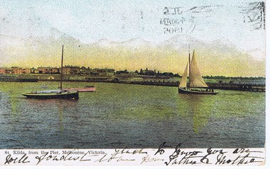 St Kilda Historical Society
Photograph, St Kilda from the Pier, 1905
postcard stamped Postcard, coloured original foreground 2 boats and pier, background in distance Marli Terrace, Esplanade hotelhand inscripton on front and back sent to London England -
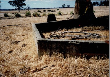 Tatura Irrigation & Wartime Camps Museum
Photograph, Children's Sand Pit Camp 3
Shows the remains of the children's sand pit which was built at Camp 3. Colour photograph on foam backing, of cement remains of a structure foundation with tree right behind and one in distance.camp 3, children's sand pit -
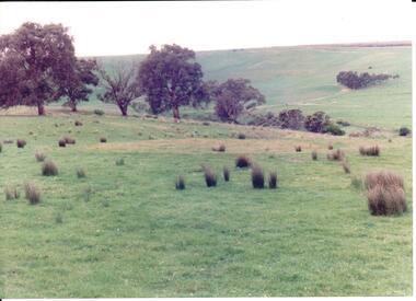 Hume City Civic Collection
Photograph, early 1990's
The 20 photographs were taken of a number of archaeological sites in Sunbury of sacred sites and aboriginal rings. The photographs were included in a study of these sites which was published by the Shire of Bulla in the early 1990's.A view of Aboriginal Ring Site near Rupertswood. The country is undulating with trees in the middle distance and the ring in the foreground.aboriginal ring sites, george evans collection -
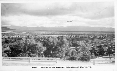 Stawell Historical Society Inc
Photograph, Panorama of Stawell from Big Hill towards the Grampians. Murray Views No. 25
Panorama of Stawell from Big Hill Murray Views No. 25. The Grampians from Lookout Post 1939Photo taken from the Grampians Lookout, Stawell. Showing The Grampians in the distance and trees filling most of the foreground.Murray View No. 25. The Grampians from Lookout, Stawell. Vic.stawell, panorama -
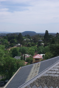 Ballarat Heritage Services
Photograph - Photograph - Colour, Mount Franklin from the Convent Gallery, Daylesford, 2015, 25/10/2015
The Convent Gallery was formerly Holy Cross Convent, and incorporates the Gold Commissioners house. An extinct volcanic mountain is seen in the distance. The slate roof of the former Holy Cross Convent in Daylesford is in the foreground. holy cross convent, presentation convent, convent gallery daylesford, slate roof, mount franklin, volcano, lalgambook -
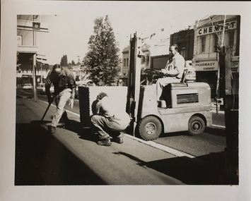 Kew Historical Society Inc
Photograph - Street Beautification: High Street
The City Engineer's Department within the former City of Kew, was responsible for public works, including in this instance, street beautification.Kew City Council workers installing planter boxes in High Street, Kew. Junction in distance at left.street beautification, city of kew -- engineers department, public works -- kew (vic.) -
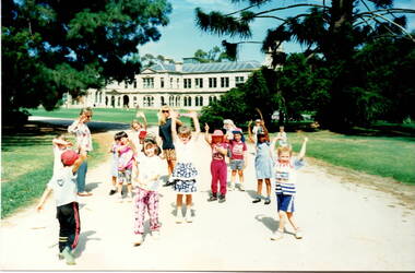 Sunbury Family History and Heritage Society Inc.
Photograph, Werribee Park Open Range Zoo, c1989
The photograph was taken when children from the Bulla primary School went on a school excursion to Werribee Park Mansion and Open Range Zoo. After doing a tour of the mansion the children stopped along the path to do some exercises together before moving on to the zoo. The excursion was part of their environmental and nature studies. The excursion to Werribee to the mansion and the zoo was included into the children's environmental and history studies. School excursions also add to their social interaction beyond the classrooms.A non-digital coloured photograph of a group of young children doing exercises in a park with a mansion in the middle distance.werribee mansion, werribee park open range zoo, bulla primary school, school excursions. -
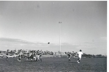 Sunbury Family History and Heritage Society Inc.
Photograph, Clarke Oval
The Sunbury Football Club, known as 'The Swifts' was formed in 1897 and the early matches were probably played on Munro's which was a stretch of land bounded by Evans, Barkly, O'Shanassy and Shields Streets. Later land adjacent to the railway line, now Sunbury Shopping Centre was where football was played until Clark Oval was opened in 1953. Since then it has been the town's main sporting venue and the site for the annual show and other events. In this photograph the football match is being played on the Clark Oval with the clubrooms visible in the background. The Sunbury Football Club is one of a number of sports clubs established vin Sunbury.A non-digital black and white photograph of a football match being played on an oval. The clubrooms are visible in the distance.sunbury football club, clark oval, "the swifts' -
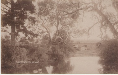 Sunbury Family History and Heritage Society Inc.
Photograph
The Jacksons Creek and the Macedon Street stone arched bridge are the features in this postcard with a view of a vineyard on the LH river bank. The wine industry was one of the early industries caroused out in Sunbury by the early European settlers in the district.A sepia photograph in post card format of a waterway with overhanging trees and an arched bridge in the middl;e distance.JACKSONS CREEK, SUNBURYjacksons creek, macedon street bridge, vineyards. -
 Vision Australia
Photograph - Image, Braille and Talking Book Library garden
Adjacent to the Braille and Talking Book Library was a small garden area. In this image, the park bench to the far left sits behind the fence facing Commercial Road.Lawn area with medium sized tree in the centre and two parks benches some distance either sidebraille & talking book library, robert de graauw -
 Lakes Entrance Historical Society
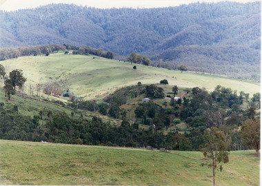
Photograph, Tambo Shire, 1994
Also second similar copyColour photograph taken at The Basin, showing hilly farmland, dense forest on ranges in distance. Buchan Victoriatopography, vegetation -
 Federation University Historical Collection
Sign, Physical Distancing in Effect, c2020
Yellow sticker for use on floor to enable physical distancing during the Covid19 pandemic (pre-vaccination development).pandemic, covid19, social distancing -
 Stawell Historical Society Inc
Photograph, Pleasant Creek Stawell from Church Hill with the Shire Hall at left under construction & the Pleasant Creek Court House visible at centre 1866
Pleasant Creek Stawell from Church Hill. Shire Hall at left under construction. Pleasant Creek Court House visible at centre. Part of a collection of Photographs by Mr. O.G. Armstrong as commissioned by the Shire of Stawell for the Inter-colonial and Paris Exhibition in Melbourne in 1866 This is a photo of what was known as Pleasant Creek but was officially Stawell 1866. It is taken from Church Hill in front of the then Church of England. This would have been at what is now about 27 Seaby Street. Note: the Pleasant Creek Courthouse about centre of the picture. Buildings at centre distance with bare ground and a few trees in foreground. Pleasant Creek Courthouse at centre of image.stawell -
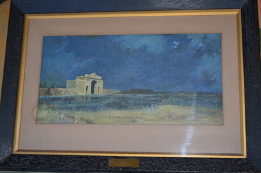 Wangaratta RSL Sub Branch
Framed print, Menin Gate at Midnight
The original art piece was painted by Australian artist Will Longstaff after he attended the unveiling ceremony of the Menin Gate memorial at the entrance of the Belgian town of Ypres in 1927. The memorial is inscribed with the names of 54,000 British and Commonwealth soldiers killed in Flanders with no known grave. More than 6000 are Australians. It was purchased in 1928 for 2000 guineas and presented to the Australia Government by British Philanthropist Lord WoolavingtonThe image commemorates those soldiers with no marked graves who died on the Western Front during the First World War.Dark wooden frame of a dark blue coloured print with large cream coloured arched monument in distance.MENIN GATE AT MIDNIGHT by Will Longstaff Presented by Lord Woolavingtonmenin gate, will longstaff, lord woolavington, ww1 -
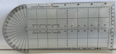 Moorabbin Air Museum
Instrument (item) - Plotter, Bearing And Distance Mark 1 A
Store Ref. No. 6B/135 No 362/40 -
Stawell Historical Society Inc
Painting, Will Rees, "Evening Shadows" of Stawell Victoria Aug, 1929
Framed painting of field trees and Grampians Range in background. Houses in distance and what may be a smokestack. 1929To Robert Rees Morcom on his 21st Birthday May 1934. From his Grandfather Will Rees and aunt Elsie Rees. -
 Lakes Entrance Historical Society
Photograph - river flats at Tambo Upper near Bruthen Victoria, 1925
Sepia toned photograph of river flats at Tambo Upper with maize crops in distance, glimpse of Bruthen VictoriaJanuary 1925 Honeymoon trip on backagriculture -
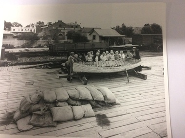 Port of Echuca
Two black and white photographs, 20/09/1984
The photograph is one of a series of photographs taken by Mike Rosel. Photographs P000027, P000028.2, P000029.3, P000030.2, P000031, P000032 are all held by Mike Rosel. This photograph shows Helen Coulson, the first Manager of the Port of Echuca, dressed in period costume, conducting a guided tour for a group of tourists, in the early 1980's. In the background another tour group is being guided through the Echuca Wharf Railway station. Shackell's Bond Store can be seen in the background. Echuca Hotel in High Street can also be seen in the distance. In the foreground there is a pile of sand bags.These photographs are significant because it shows Helen Coulson as a tour guide. It also shows that High Street could be seen from the wharf in the 1980's. These photographs also show the state of the wharf then.2 black and white photographs exactly the same,of tourists standing around a row boat which is sitting on top of the Echuca wharf. The tourists are listening to Helen Coulson, who is dressed in period costume. In the foreground is a pile of sand bags. More tourists can be seen in the background involved in a tour of the Echcua Wharf railway station. Shackell's Bond Store can be seen in the middle background, and Echcua Hotel, in High Street can be seen in the distance.There are no inscriptions or markings.helen coulson, shackell's bond store, echuca hotel, tourism, rosel, mike, echuca wharf -
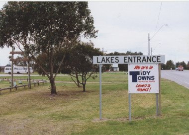 Lakes Entrance Historical Society
Photograph - Tidy Towns signs Lakes Entrance Victoria, Lakes Entrance Tidy Town Committee, 1990 c
Colour photograph of Tidy Town signs at the western entry adjacent to Apex Park, the original Information Centre in the distance Lakes Entrance Victoria . Other colour photograph of western entry to Lakes Entrance with the refurbished Information Centre and two small tourist buses in distance 04249.1 transport, roads and streets, tourism, signage -
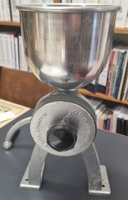 Wodonga & District Historical Society Inc
Domestic object - Grain Mill
Flour has been produced for centuries by grinding a variety of grains to make flour. In the early years of the Retsel Corporation established 1962, their designers carried out research which convinced them that grinding of flour between slow turning stones produced a better quality of flour. They continue to market grain mills similar to this item. The black knob on the side allows for the distance between the stones to be adjusted so that flour of varying coarseness can be milled. Grain mills such as this were used widely throughout the Wodonga district in the late 20th Century and have had a resurgence in many areas.This item is significant because it is representative of domestic appliances used in the Wodonga district.A grain mill made from metal with two grinding stones. The small black knob on the side enables the distance between stones to be adjusted. Each foot has holes to allow the mill to be screwed to a bench for added stability. The long handle is used to turned to drive the machine. The large funnel is set into a hole on the top of the mill to hold grain. Another bowl would be placed underneath the outlet at the bottom to catch the flour.On handle and circular disc: RETSEL CORPORATION McCAMMON IDAHO 83250domestic appliances, grain mills -
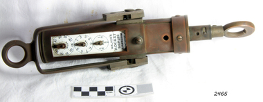 Flagstaff Hill Maritime Museum and Village
Ship Log, 1900-1920
Thomas Walker & Son was internationally renowned in the manufacturing of ships logs. Founding father Thomas Walker (1805–1871), an engineer in Birmingham, patented a mechanical log in 1878 which was a recording instrument that attached to a rail at the stern of a vessel connected by a long cord with a rotor which was towed behind the ship. The instrument dial recorded the distance travelled. Thomas Walker first went into business to manufacture stoves at 58 Oxford Street Birmingham. Walker’s self-feeding stove was widely lauded at the Paris Exhibition of 1855, winning a prize medal and kick starting the first of many notable innovations for the Walker family's manufacturing business. However, it wasn’t until working on an earlier ships log model invented by his Uncle that Thomas Walker became interested in the further development of this device, used to ascertain a ship’s speed. Walker continued to improve on the common log for the company of Massey & Sons and these improvements were deemed revolutionary. This log became a firm favourite of the West India Association (British-based organisation promoting ties and trade with the British Caribbean) and the most common log in use for two generations. It took till 1861 for Thomas Walker and his son, Thomas Ferdinand Walker (1831-1921) to patent the first Walker log of many. Together, with the introduction of the A1 Harpoon Log two years later, they established the Walker Log Business as a force to be reckoned with. By the time of his passing in 1871, Thomas Walker Snr had not only founded a family business with considerable staying power but also instilled a tradition of public service. Having sat as a representative on the Birmingham Town Council for 15 years and played an active role in public works, he was soon given the nickname of ‘Blue Brick Walker’. Much like his father, Thomas Ferdinand Walker changed the face of the maritime industry. His patent of 1897, the ‘Cherub’ log, was a notable departure from the past providing a far more accurate reading and replacing the majority of logs of the age. They were the first to produce an electric log and the Walker factory was one of the first to introduce the 48 hour work week for employees. This ship log was invented and made by a significant marine instrument maker and innovator of machinery. It demonstrates the huge leap taken to improve navigational accuracy at sea with an instrument that was in use for decades. Ship Log, three analogue dials calibrated in increments of Miles, the Rocket Log is a nautical instrument for measuring a vessel’s speed and distance traveled. The floating log was drawn behind the ship over a fixed time period in order to measure the distance traveled. The counter could measure enough miles to cover the maximum distance traveled by a ship in one day. The log has two distinct parts; a brass register, made by Walker, showing the distance recorded and the rotator made by Reynolds, that spins in the water driving the counter. both parts are connected by a linked chain. The register has a cylindrical brass body approx 4.5 cm diameter containing registering mechanism with hardened steel bearings. Distance is indicated by the three pointers on enamel plate as follows: graduated every 10 miles from 0-100; every mile from 1-10; every 1/4 mile from 1/4 -1. A brass sling and eye secured to the body enables it to be attached to the taffrail. The original rotator would have had a cylindrical tapered wooden body, approx 4.5 cm in diameter with three metal alloy fins or could be all made from brass. A towing eye is fitted to the tapered end. The two pieces of apparatus are connected by a length of linked chain, length 22.9 cm."Walkers Rocket Ship-Log Birmingham (Patented)" printed on face-plate. "Made by Thomas Walker".flagstaff hill, warrnambool, shipwrecked-coast, flagstaff-hill, flagstaff-hill-maritime-museum, maritime-museum, shipwreck-coast, flagstaff-hill-maritime-village, ship log, rocket log, mechanical ship log, measuring instrument, marine instrument, nautical instrument, speed recording instrument, ship log register, walker ship log, walkers rocket ship-log, thomas walker, thomas walker & son, thomas ferdinand walker, walker log business, reynolds ship log rotor, taffrail log, taff rail log, west india association -
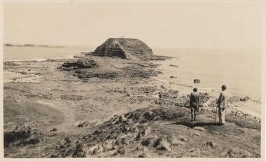 Phillip Island and District Historical Society Inc.
Photograph, 20th Century
Selection of 6 photographs and postcards of The Nobbies, A Seal and the SS Killara, donated by D Reid.A selection of postcards and photograph Black & White and Coloured of The Nobbies, a Seal and the SS Killara. Photo 1. View of the Nobbies with two people in the foreground. Photo 2. View of the Nobbies with a Horse and jinker in the foreground. Photo 3. A Seal resting on the rocks at Seal Rocks Phillip Island Photo 4. The Ferry steamer S. S. Killara arriving at Cowes Photo 5. Coloured view of the Nobbies looking across breakers on the rocks. Photo 6. Coloured coastal view looking towards the Nobbies in the distance.Inscriptions on the front of postcards Photo 2. The Rose Series. P 666. Looking to The Nobbies, Phillip Island, Victoria Photo 3. The Rose Series. P 747. A Seal on the rocks, Phillip Island, Victoria Photo 4. The Ferry Steamer S. S. "Killara" arrives at Cowes. Photo 5. The Nobbies, Cowes Photo 6. Coastal Scene Cowes. Nobbies in Distance.the nobbies phillip island, wildlife - seals, seal at seal rocks, ss killara, ferries -
 Marysville & District Historical Society
Photograph (Item) - Colour photograph, Travel Victoria, 2006
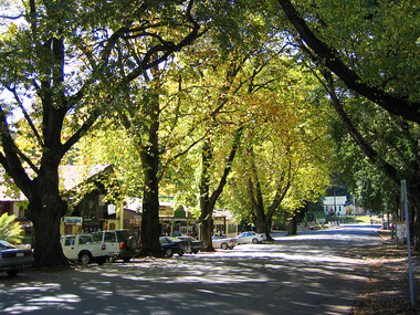
A colour photograph of Murchison Street in Marysville in Victoria.A colour photograph looking down Murchison Street in Marysville in Victoria. The buildings along Murchison Street, including the Christ Church, were destroyed in the 2009 Black Saturday bushfires.murchison street, marysville, victoria, christ church, photograph, 2009 black saturday bushfires -
Federation University Historical Collection
Photograph, Ballarat School of Mines Buildings, Lydiard Street South, Ballarat, c1980
Black and white photograph of the Ballarat School of Mines buildings in Lydiard Street South, Ballarat. Gaol Gates in the distance.ballarat school of mines, lydiard street south, ballarat goal gates -
Glenelg Shire Council Cultural Collection
Negative - Negative - Glenelg River, Nelson, Victoria, Miss Zillah Maschmedt, photographer, c. 1936
Negative for a black and white photograph. Image shows Glenelg River, Nelson, Victoria, sand dunes at mouth in distance. -
 Halls Gap & Grampians Historical Society
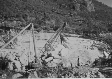
Photograph - B/W, C 1955
This copy b/w - other 2 copies catalogued separately (both coloured) Heatherlie quarry Heatherlie quarry - Photo shows 2 people standing in quarry. Machinery; in foreground; rock-face middle distancequarrying, mt difficult quarry