Showing 229 items matching " east boundary"
-
 Port Melbourne Historical & Preservation Society
Map - Footscray, Public Lands Office, 19 Oct 1857
Map of Footscray, west of Saltwater Creek; south of Hopkins Street, east of Railway and north southern boundary of Botanical Garden reserve.The Township of Footscray, Parish of Cut-Paw-Pawfootscray -
 Victorian Interpretive Projects Inc.
Photograph - Colour, Clare Gervasoni, Sculpture of Portuguese explores at Warrnambool, 02/09/2012
The sculptural installation was a gift from the Portuguese government and presented to Warrnambool City Council. The sculptor, Jose Nuncio, completed the work in 1999, and it was inaugurated at Warrnambool in 2001. Prince Henry the Navigator founded a school of navigation in Sagres, Portugal. This led to navigation techniques that made the 15th century voyages of discovery possible. The vision of Prince Henry brought together ship builders, cartographers, instrument makers and mathematicians. Vasco de Gama rounded the southern tip of Africa and sailed across the Indian Ocean to India in 1496. This started a new era of trade and exploration, expanding the boundaries of the known world, and linking the east with west.Six colour photographs of a sculptural installation at Warrnambool. Busts of Vasco De Gama and Prince Henry the Navigator feature in the installation. Images also include two informative plaques containing information on De Gama and the Prince.warrnambool, exploration, navigator, de gama, prince henry the navigator, portugal, portuguese, david atkinson, john pandazopoulos -
 Victorian Aboriginal Corporation for Languages
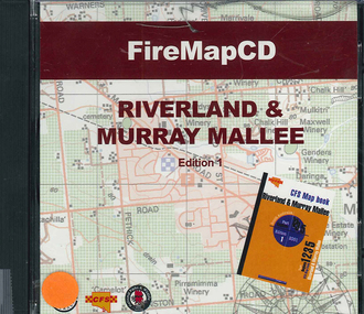
CD-ROM, Country Fire Services South Australia, FireMapCD Riverland &? Murray Mallee, 2001
The area covered by this map is the same as the CFS Riverland & Murray Mallee Map Book. The area covered adjoins the Mount Lofty Ranges map book on the eastern boundary at Murray Bridge, north to Morgan and east to Renmark and the State Border. It extends southwards to join the northern boundary of the Lower South East map book at Padthaway.CD-ROMfire protection, victorian maps -
 Uniting Church Archives - Synod of Victoria
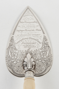
Ceremonial object - Commemorative Trowel
Decorated silver trowel with bone handle.Presented to John Thompson Esq on the occasion of laying a Memorial Stone of Boundary Street Congregational Mission Church Southport. 23rd May 1890.congregational mission church southport -
 Nillumbik Shire Council
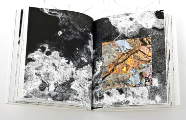
Artist Book: Tommaso DURANTE (b.1956 ITA, arrived. 2001 AUS) with text by Chris WALLACE-CRABBE (b.1934 AUS), Skin, Surfaces and Shadows, 2007
'Skin, Surfaces and Shadows' was created by Tommaso Durante in 2004 during his stay in Bundanon (gifted to the Australian people by Arthur & Yvonne Boyd - South East Australia) as international artist in residence and it was enriched during the artist’s stay in Broome (Western Australia) in 2005. On that occasion he collected the raw materials that were subsequently wrought to develop the actual bookwork.On the edge of artistic practice and philosophical inspiration, 'Skin, Surfaces and Shadows' pushes the boundaries of art, craft and design by combining digital technologies with traditional techniques and materials. Durante visually explores the surfaces of organic things (trees, surface textures, etc.) and the figurative dividing line of the shadow. The poet Wallace-Crabbe responds to these images in words. The poet and the artist flit in and out of shadows, skin and the surfaces of paper and life.(a) prints, artist's book (80 pages), ink; Somerset Book White paper (175gsm), digital images, printed in eight inkjet colour pigments, from digital files. Set in digital typefaces Utopia STD Display, Italic and Bold, Frutiger 57 Condensed, 67 Bold Condensed, and 56 Italic. Section sewn around 3 tapes. Full paper binding with blind blocking on front cover handmade head and tail bands. (b) CD of slide presentation to accompany bookwork on display Primary Insc: In black biro, signed and editioned by Tommaso Durante and Chris Wallace-Crabbe (last page '8/25 T DURANTE CWallace-Crabbe')prints, artist book, skin, surface, shadow, poetry, durante, wallace-crabbe -
Koorie Heritage Trust
Book, Department of Pacific and Southeast Asian History, Australian National University, Aboriginal History - Volume 08. 1-2 1984, 1984
This volume of 'Australian History' is devoted to studies of the south-eastern corner of the Australian continent. The papers arose from a series of meetings convened with Professer R. W. Dixon in 1981. They involved scholars from the disciplines listed, all concerned with the south-east. A series of articles by leading writers on Aboriginal History.237 P.; ill,; figs.; tables; notes; reviews; 24 cm.This volume of 'Australian History' is devoted to studies of the south-eastern corner of the Australian continent. The papers arose from a series of meetings convened with Professer R. W. Dixon in 1981. They involved scholars from the disciplines listed, all concerned with the south-east. A series of articles by leading writers on Aboriginal History.aboriginal australians -- periodicals. | ethnology -- australia -- periodicals. | settlement and contacts - colonisation - 1788-1850 | race relations - violent - massacres, murders, poisonings etc. - to 1900 | sex relations | indigenous knowledge - world view | language - personal names | language - semantics | social identity | language - sociolinguistics | government policy - state and territory - new south wales | socioeconomic conditions - living conditions | language - linguistics - language classification | language - vocabulary - word lists | language - linguistics | geography - territories and boundaries | art - rock art - painting | art - production - materials / techniques | art - art motifs | -
Whitehorse Historical Society Inc.
Article, Thousands switch seats; Deakin spills east, 1968
Photocopy of article about an electoral redistribution which transfers part of Box Hill from Bruce to Deakin.Photocopy of article about an electoral redistribution which transfers part of Box Hill from Bruce to Deakin. The changes also affect Blackburn, East Burwood, Forest Hill, Vermont and Heatherdale.Photocopy of article about an electoral redistribution which transfers part of Box Hill from Bruce to Deakin. electoral boundaries, box hill, blackburn, burwood east, forest hill, vermont, heatherdale, jarman, alan -
Whitehorse Historical Society Inc.
Map, Aerial Photographs Nunawading, 1970
State Aerial Survey, Melbourne 1970.State Aerial Survey, Melbourne 1970. Project runs 34 - 39 - City of Nunawading. Frames numbered from South to North boundaries, each strip numbered from East to West. See table of index and photo numbers attached.non-fictionState Aerial Survey, Melbourne 1970.state aerial survey, aerial photographs, nunawading, mitcham, blackburn, blackburn north, blackburn south, forest hill, vermont, burwood east, vermont south -
Whitehorse Historical Society Inc.
Map, Aerial photographs Nunawading, 1972
Department of Crown Lands and Survey, Melbourne, 1972.Department of Crown Lands and Survey, Melbourne, 1972. Project runs 34 - 39 - City of Nunawading. frames numbered from South to North boundaries, each strip numbered from West to east. The series extends further West to Box Hill and East to Ringwood than the 1970 project. No index map. Sheets 39/2 and 34/28 missing.non-fictionDepartment of Crown Lands and Survey, Melbourne, 1972.victoria. department of crown lands and survey, aerial photographs, nunawading, mitcham, blackburn, blackburn north, blackburn south, forest hill, vermont, burwood east, box hill, ringwood, vermont south -
Whitehorse Historical Society Inc.
Map, Aerial photographs Nunawading, 1976
Department of Crown Lands and Survey, Melbourne, 1976 Project.Department of Crown Lands and Survey, Melbourne, 1976 Project. Runs 29 - 33 City of Nunawading. Frames numbered from South to North boundaries, each strip numbered from West to East. No index map. Sheets 30/8 and 30/9 missing.non-fictionDepartment of Crown Lands and Survey, Melbourne, 1976 Project. victoria. department of crown lands and survey, aerial photographs, nunawading, mitcham, blackburn, blackburn north, blackburn south, forest hill, vermont, vermont south, burwood east, box hill, ringwood -
Whitehorse Historical Society Inc.
Map, Aerial maps, 2/04/1966 12:00:00 AM
Melbourne 1966 project, runs 10A and 11A, lens 122 151.75 mm 9,800. Photo nos 77, 107, 109, 161, 163, 165.Melbourne 1966 project, runs 10A and 11A, lens 122 151.75 mm 9,800. Photo nos 77, 107, 109, 161, 163, 165. Areas and boundaries: Map no 77 W. Park and Cook Roads; E. Dubon Rd; N Oban Rd; S Reilly St. Map No 107. W. Indra Rd and Pakenham St; E. Rooks Rd & McLares Rd; N. Maroondah Hwy; S. Hawthorn Rd & Eley Rd. Map No 109 W. Elgar Rd. E. Blackburn Rd & McKean St; S. Eley Rd & Burwood Hwy. Map No 161. W. Elgar Rd & Huntingdale Rd; E. Blackburn Rd; N. Burwood Hwy; S. Waverley Rd. Map No 163. W. Blackburn Rd; S. Springvale Rd; N. Eley Rd & Hawthorn Rd; S. Glen Waverley Railway Line. Map No 165. W. Stanley Rd, Vermont South; E. Cathies Lane, Wantirna South; N. North of Burwood Hwy; S. High Street. Melbourne 1966 project, runs 10A and 11A, lens 122 151.75 mm 9,800. Photo nos 77, 107, 109, 161, 163, 165. aerial photographs, blackburn, blackburn south, forest hill, nunawading, box hill, burwood, burwood east, donvale, mount waverley, glen waverley, wantirna, vermont south, mitcham, ringwood north, ringwood -
Whitehorse Historical Society Inc.
Document, History of Tally Ho Boys Home, 1972
... Boundary Road Burwood East... Mrs Hoadley Abel Boundary Road Burwood East Highbury Road ...Three papers on History of Boys Training Farm, Highbury Road, Tally Ho3 papers on History of Boys Training Farm, Highbury Road, Tally Ho, commenced in 1903 by Rev. and Mrs George Cole. The story covers the period from 1903-1930. The farm was built on land bought from Abel Hoadley for 1,000 Pounds near the corner of Springvale Road in Boundary Road (now Highbury Road). 2 letters (16/7/1972 & 28/5/1972) to Nancy Leach from E. Hinneberg, Assistant Superintendent, Tally Ho, about his association with Tally Ho.Three papers on History of Boys Training Farm, Highbury Road, Tally Hoyouth services, tally ho boys home, cole, george, rev., cole, mrs, hoadley, abel, boundary road burwood east, highbury road, burwood east, springvale road, burwood east, leach, nancy, hinneberg, ernest. -
 Whitehorse Historical Society Inc.
Map, Shire of Nunawading 1888
... Mitcham melbourne shire of nunawading. south riding south boundary ...Plan showing owners of land in the South Riding of the Shire of Nunawading, 1888. South Boundary Road is now Highbury Road.shire of nunawading. south riding, south boundary road, burwood east, highbury road, springvale road, mahoneys road, forest hill, holland road, blackburn south, burwood highway -
Whitehorse Historical Society Inc.
Map, City of Nunawading, c. 1960
Map showing boundaries of the City of Nunawading Scale: 1:36,000Map showing boundaries of the City of Nunawading Scale: 1:36,000Map showing boundaries of the City of Nunawading Scale: 1:36,000mitcham, nunawading, blackburn, blackburn north, blackburn south, burwood east, vermont south, forest hill, vermont -
Whitehorse Historical Society Inc.
Document, Harkaway National School
Description and history of Harkaway National School, plus changing of many street names and early pioneers.Description and history of Harkaway National School, plus changing of many street names and early pioneers.Description and history of Harkaway National School, plus changing of many street names and early pioneers.pioneers, harkaway national school, burwood east state school no 454, thompson, john edward, street names, ballyshanassy road, boundary road, delaney's road -
 Whitehorse Historical Society Inc.
Article, Dempsey's Boundary Hotel, 1873
An article about Dempsey's Boundary Hotel, NW. cnr Highbury & Middleborough Roads, East Burwood.An article about Dempsey's Boundary Hotel, NW. cnr Highbury & Middleborough Roads, East Burwood. Licensees Mary Anne & William Dempsey.An article about Dempsey's Boundary Hotel, NW. cnr Highbury & Middleborough Roads, East Burwood. dempsey, william, boundary hotel, green mount, dempsey, mary ann, parish of nunawading -
 Ballarat Heritage Services
Photograph - Colour, Clare Gervasoni, Fawcett Hall and Public Library, 2015, 11/01//2015
Fawcett Hall is 14 kilometres North West of Alexandra, North East Victoria, in Spring Creek Road and is set amongst a small picturesque rural farming and business community with hills as a backdrop and Stony Creek running alongside the public reserves property boundary. Part of our hall building dates back to its establishment in 1882. Originally the hall served as a Mechanics Institute and Public Library and later as a primary school.Colour photograph of a weatherboard Hall.fawcett hall and public library, fawcett, fawcett mechanics' institute -
 Royal District Nursing Service (now known as Bolton Clarke)
Photograph - Photograph, black and white, Barry Sutton, 01.05.1974
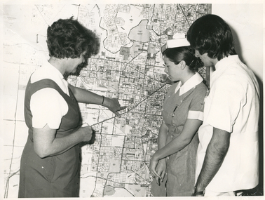
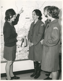
Sister Ellen Anderson is the Supervisor of the Royal District Nursing Service, (RDNS) Footscray Centre. She is wearing her RDNS uniform of a short sleeve white blouse under a royal blue V neck tunic style dress. Sr. Anderson is showing two Student nurses from Western General Hospital the map with the areas covered by Footscray Centre. The map had different colour pins to identify streets where patients lived who were currently receiving nursing care from RDNS Sisters working in these areas (districts).During their training, Student nurses from several hospitals either attended the Royal District Nursing Service (RDNS), Education Department, or, a RDNS Nurse Educator travelled to the appropriate hospital’s Education Department to educate the Trainees on District nursing through the RDNS Community Nursing Program. Following the lectures Students went to a RDNS Centre and each Student accompanied a Trained nurse (Sister) for a week observing and gaining knowledge of all facets of nursing care in the home. This gave them an insight into the home conditions and situations patients faced after discharge from hospital. During 1971 there were 584 Student nurses who received field experience with RDNS. From its inception as Melbourne District Nursing Society (MDNS), in 1885, their Trained nurses (Nurses) worked in specific areas, 'districts'. The first Nurse worked east and west, between Victoria Parade and Flinders Street and, north and south, between Spencer Street and Spring Street. When a second Nurse was employed they divided this area at Elizabeth Street so each Nurse could attend to patients in the same area giving continuity of care. As the Society expanded, becoming Melbourne District Nursing Service, then, with Royal patronage, Royal District Nursing Service (RDNS) many Centres were opened throughout the Melbourne Metropolitan area and outer suburbs. The District nurse's areas (districts) grew and were divided within Shire boundaries for e.g. Knox 1, Knox 2, Knox 3, Knox 4, within the area of the Shire of Knox. A map covering the Centre’s Districts was attached to a wall, and its different colour pins identified streets where patients lived who were currently receiving nursing care from the RDNS Trained nurses (Sisters) working in these areas (districts).On the left of this black and white photograph is Royal District Nursing Service (RDNS), Sister Ellen Anderson, who has short dark curly hair and is wearing her RDNS uniform of a short sleeve white blouse under a dark V neck tunic style frock. She is standing side-on, towards the right of the photograph, and with her left hand is pointing to an area on a large map attached to the wall in the background. To her right, is a Student nurse who is facing Sr. Anderson, and looking at the area on the map. Under her white nurses cap, she has her long dark hair drawn back, and is wearing her hospital uniform of a short sleeve checked dress with white collar and cuffs; a nursing watch is attached to its upper left; her hands are clasped in front of her. To her right, is a male Student nurse who has collar length straight dark hair, and is wearing white trousers and a short sleeve white top with pens in the left upper pocket. He is looking at the areas on the map.. Barry Sutton MA 77 informationroyal district nursing service, rdns, rdns education, rdns centre, rdns district map, sister ellen anderson -
 Royal District Nursing Service (now known as Bolton Clarke)
Photograph - Photograph, black and white, Barry Sutton, 01.05.1974
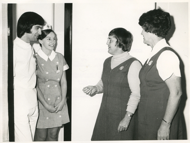
The photograph is taken at Western General Hospital. Royal District Nursing Service (RDNS) Nurse Educator, Sister Nan Deakin, after teaching the RDNS Community Nursing Education program to the Western General's two Student nurses is introducing them to Sister Ellen Anderson, Supervisor of the RDNS Footscray Centre. Sr. Anderson will arrange for the Students to go on District nursing visits with RDNS Trained nurses (Sisters) from Footscray Centre who administer nursing care in the community. Sister Deakin is wearing the RDNS winter uniform of a blue/grey skivvie under a blue/grey V neck tunic style frock made of herringbone winter material. Sister Anderson is wearing the RDNS summer uniform of a white short sleeve blouse under a royal blue V neck tunic style frock. The RDNS logo is seen on the upper left on both uniforms.During their training, Student nurses from several hospitals either attended the Royal District Nursing Service (RDNS), Education Department, or, a RDNS Nurse Educator travelled to the appropriate hospital’s Education Department to educate the Trainees on District nursing through the RDNS Community Nursing Program. Following the lectures Students went to an RDNS Centre and each Student accompanied a Trained nurse (Sister) for a week observing and gaining knowledge of all facets of nursing care in the home. This gave them an insight into the home conditions and situations patients faced after discharge from hospital. During 1971 there were 584 student nurses who received field experience with RDNS. From its inception as Melbourne District Nursing Society (MDNS), in 1885, their Trained nurses (Nurses) worked in specific areas, 'districts'. The first Nurse worked east and west, between Victoria Parade and Flinders Street and, north and south, between Spencer Street and Spring Street. When a second Nurse was employed they divided this area at Elizabeth Street so each Nurse could attend to patients in the same area giving continuity of care. As the Society expanded, becoming Melbourne District Nursing Service, then, with Royal patronage, Royal District Nursing Service (RDNS) many Centres were opened throughout the Melbourne Metropolitan area and outer suburbs. The District nurse's areas (districts) grew and were divided within Shire boundaries for e.g. Knox 1, Knox 2, Knox 3, Knox 4, within the area of the Shire of Knox. A map covering the Centre’s Districts was attached to a wall, and its different colour pins identified streets where patients lived who were currently receiving nursing care from the RDNS Trained nurses (Sisters) working in these areas (districts).On the far left of this black and white photograph is a male Student nurse, who has collar length, straight dark hair. He is wearing his hospital uniform of white trousers and top. To his right, is a Student nurse who is wearing her white nursing cap, with motif in the centre front, over her long drawn back dark hair. and her short sleeve uniform checked frock, with white two breasted buttons down it, and with white collar and cuffs. A nursing watch is attached to its upper left. Both are standing in the dark framed doorway of a room and are looking to the right and smiling at Royal District Nursing Service (RDNS), Nurse Educator, Sister Nan Deakin. She has short dark hair; is wearing glasses, and is wearing her RDNS uniform of a light grey skivvie under a darker V neck tunic style frock. To the right of her, is RDNS Sister Ellen Anderson who has short curly dark hair and is wearing her RDNS uniform of a white short sleeve blouse, under a dark V neck tunic style frock. They are standing side-on facing the Students. Barry Sutton MA 78royal district nursing service, rdns, rdns education, western general hospital students, sister nan deakin, sister ellen anderson -
 Ballarat Tramway Museum
Map, Electric Supply Co. of Vic (ESCo), Ballarat Electoral Map - ESCo, 1900
Document prepared by the Electric Supply Co of Victoria, as part of an order under the Electric Light and Power Act 1896, section 5 of order No. 17 granted to company. Dated 19/2/1901 and signed by the Postmaster-General. Shows the order area being parts of the City of Ballaarat, Sebastopol and Ballarat East. Shows the street names, boundaries, principal power line routes, land reserves, parks, mine locations, railways and Lake Wendouree. Signed by R L Williams Town Clerk City of Ballarat, J R Hall for the Borough of Sebastopol, and John Gent for the Town of Ballarat EastYields information about the power supply to the Ballarat area.Cloth backed paper map, coloured and marked up as exhibit 17.Notes in ink including the signature of Benjamin Deakin 24/9/00 and certified by the three involved municipal Town Clerks.ballarat power supply, esco, electric supply co of victoria, city of ballaarat, east ballarat, sebastopol, orders, power lines, power supply -
 Bendigo Historical Society Inc.
Document - GERMAN HERITAGE SOCIETY COLLECTION: MAPS OF GERMANY (PERIODS OF CHANGE)
Item 21. Maps of Germany (Periods of Change) held in two buff coloured commerce folders. Name written on the front in purple. Three loose copies of the Thirty Years War Map 21a, 21c and 21d. Maps of the Thirty Years War,Europe at the End of the 15th Century, The Reformation in Europe (16th Century), /Europe in the Time of Charles II & James II, The Domination of France 1660 - 85, Europe in the Time of Henry VIII, Germany in 1807 after reconstruction by Napoleon, German Federation 1815, The German Federation 1815, The German Empire of 1871, The Growth of the German Zollverein, Boundaries Before 1918 showing Kingdoms, Duchies, Provinces, etc., of the Former German Empire, the German Empire (1871 - 1918), and Boundaries before 1918 showing Kingdoms, Duchies, Provinces, etc., of the Former German Empire. The last page has a small map of Europe, a small map showing East and West Berlin, German Coats of Arms, Comparative International Figures of Population and a short article titled 'Do You Know Germany'.document, certificate, maps of germany, german heritage society collection - maps of germany (periods of change) -
 Kew Historical Society Inc
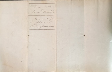
Legal record (Item), Thomas Judd to James Bonwick: Agreement for Sale of Land at Parish of Boroondara, 1853, 28/02/1853
James Bonwick (1817-1906), the Victorian educator and historian, acquired land in Kew on which to establish a home and school in 1853, not 1854 as more commonly stated. Bonwick returned to England in 1859 for a period, later returning to Melbourne and settling in St Kilda. He was the author of a number of histories and an official transcriber of Government records.This newly acquired document, from a former owner of 'Parkhill' (20 Hillcrest Avenue, Kew), is of statewide importance as it is the original copy of the agreement made between Thomas Judd of Parkhill and James Bonwick in 1853 for the purchase of land in Kew. Both Thomas Judd and James Bonwick were significant pioneers of Victoria.TRANSCRIPT [TITLE] Thomas Judd to James Bonwick Agreement for Sale of Land at Parish of Boroondara [PAGE 1] Articles of agreement made and entered into this the Twentyth eighth day of February One thousand Eight Hundred and fifty three Between Thomas Judd of Melbourne in the Colony of Victoria Gentleman of the one part and James Bonwick of Melbourne in the Colony of Victoria Gentleman of the other part whereby the said Thomas Judd agrees to sell unto the said James Bonwick who hereby agrees to purchase a piece or parcel of land containing two and half acres be the land more or less part of Portion Number Eighty five of the Parish of Boroondara in the County of Bourke commencing at a point on the Northern boundary line of the said Portion Seventeen Chains fifty links East from the North West angle of the same and bounded on the East by other part of said Portion in a line bearing South Eight Hundred and sixty two feet on the South by other part of said Portion Eighty five in a line bearing West one Hundred twenty six and half feet on the West by other part of said Portion Eighty five in a line bearing North Eight Hundred and Sixty two feet on the North by the Northern boundary line of the said Portion Eighty five in a line bearing East one Hundred twenty six and half feet to the commencing point at or for the price or sum of one [PAGE 2] One Hundred Pounds to be paid and payable in the manner hereinafter mentioned that is to say the Sum of Thirty pounds to be paid on the day of the date hereof and the sum of forty pounds by the acceptance of the said James Bonwick for that sum at three months bearing interest thereon after the rate of Eight Pounds per centum per annum and the Sum of Thirty pounds by the acceptance of the said James Bonwick for that sum after Six months with interest thereon after the rate of Eight pounds per centum per annum It is furthermore agreed that the said James Bonwick shall have access by a right of way fifteen feet wide reserved by the said Thomas Judd to the Government Road being the Southern Boundary of Portion Eighty five. That in case default shall be made in the payment of any of any of the Acceptances above mentioned the amount paid shall be actually forfeited to the said Thomas Judd who shall be at liberty to resell the premises. That upon payment of the whole amount of the purchase money the said Thomas Judd shall execute a conveyance of the premises to the said James Bonwick Such conveyance to be prepared by and at the expense of the said James Bonwick who - [PAGE 3] who shall also pay the cost of any attested copies he may require. ---- As witness the hands of the said parties this the twenty first day of February one thousand Eight Hundred and fifty Three. ----- [Signature] T. Judd [Signature] Jas Bonwick Witness [Signature illegible] £ Received Cash on account of the above 30.0.0 Thirty Pounds Bill at three Months with interest 42.4.0 Bill at Six Months with interest 31.4.0 _____ £103.8.0 _____ [Signature] T. Judd [Signature] Jas Bonwick ------------ Transcribed David White 25/08/2020 james bonwick, thomas judd, land titles - kew (vic), pioneers - kew - victoria -
 Kew Historical Society Inc
Photograph - High Street, Kew, 1960-65
The borders of the main components of Kew and Kew East have not always conformed to current boundaries. In the past this photograph has been labelled as East Kew, whereas for most of the twentieth century the site has been within Kew's borders. The purpose of the photograph is unrecorded yet it has value in that it shows those businesses who occupied this site in Kew during the early 1960s.This small photograph is significant as it shows the location of and building used by WD Vaughan, former Mayor of Kew who was a successful newspaper proprietor in Melbourne.Small polaroid colour positive of High Street in Kew, probably in the 1960s. From left we can see the brick viaduct covering the tracks of what was once the Outer Circle Railway. Behind this brick wall, Dunnings Timber Yard was situated. At the end of the walls of the viaduct there is an entrance to a walkway [now the Anniversary Trail], which once provided access to Windsor Avenue, and also to the East Kew Station (now demolished and part of the Outer Circle Railway Reserve). On the other side of this walkway is a cream brick building (demolished) occupied at this time by WD Vaughan Pty Ltd, printer and publisher of the Kew Advertiser (newspaper). Stretching behind the brick facade is an extensive building that must have housed the printing works. Beside Vaughan's, there is a large building (demolished) housing at that time an estate agent named AJ Kennedy. This area is now separated by kerbing.High St East Kew / Corner of Harp Rd. / Looking South -
 Kew Historical Society Inc
Photograph - Civic event in Stradbroke Park, 1976
Stradbroke Park. Extent: Kilby Road to Harp Road at Burke Road. Historical Documentation: 1851 - Portion 91 purchased by Edward Glynn; 1888 - The Harp of Erin Estate (which included Section 91) offered for sale; 1896 - The area now known as Stradbroke Park was bisected by a creek that flowed from the Yarra via Hay's Paddock (q.v.) and extended through to Burke Road; 1943 - W.D. Birrell, Town Clerk of Kew, proposed that the creek be filled and a reserve created; 1954 - Entire area designated as 'open space' and named 'Stradbroke Park'. The line of the creek that ran through the Park created a further reserve on the north side of High Street, now known as 'Harrison Reserve'. Existing Condition: The park is largely of mown grass that has mature trees set into it It is possible that a number of these are remnant of the original vegetation, while there are also a number of exotic trees introduced, particularly at the northern end of the park. The southern end is dominated by playing fields. (Source: Sanderson, P 1988. Kew Conservation Study)Colour photographic positive (with colour degradation) of sporting teams at a civic event in Stradbroke Park in Kew East in May 1976. The event was officiated by the Mayor of Kew, Cr Alan Hutchinson. Sporting teams in uniform included: footballers, athletes, cricketers, hockey players. Stradbroke Park is situated on the western boundary of Kew at Burke and Harp Roads.stradbroke park, cr alan hutchinson, team sports -- kew (vic.) -
 Kew Historical Society Inc
Photograph - Civic event in Stradbroke Park, 1976
Stradbroke Park. Extent: Kilby Road to Harp Road at Burke Road. Historical Documentation: 1851 - Portion 91 purchased by Edward Glynn; 1888 - The Harp of Erin Estate (which included Section 91) offered for sale; 1896 - The area now known as Stradbroke Park was bisected by a creek that flowed from the Yarra via Hay's Paddock (q.v.) and extended through to Burke Road; 1943 - W.D. Birrell, Town Clerk of Kew, proposed that the creek be filled and a reserve created; 1954 - Entire area designated as 'open space' and named 'Stradbroke Park'. The line of the creek that ran through the Park created a further reserve on the north side of High Street, now known as 'Harrison Reserve'. Existing Condition: The park is largely of mown grass that has mature trees set into it It is possible that a number of these are remnant of the original vegetation, while there are also a number of exotic trees introduced, particularly at the northern end of the park. The southern end is dominated by playing fields. (Source: Sanderson, P 1988. Kew Conservation Study)Colour photographic positive (with colour degradation) of sporting teams at a civic event in Stradbroke Park in Kew East in May 1976. The event was officiated by the Mayor of Kew, Cr Alan Hutchinson. Stradbroke Park is situated on the western boundary of Kew and bordered by Burke and Harp Roads.stradbroke park, cr alan hutchinson, team sports -- kew (vic.) -
Glen Eira City Council History and Heritage Collection
Document (Item) - Newspaper (digital), Caulfield Contact
The Caulfield Contact was the official newspaper of the City of Caulfield from 1976-1994. The City of Caulfield was the Municipal Council for an area of the South Eastern suburbs of Melbourne, including Brighton East, Carnegie, Caulfield, Elsternwick, Gardenvale, Glen Huntly, McKinnon, Murrumbeena, Ormond and St Kilda East. Following the amalgamation of City of Caulfield and parts of the City of Moorabbin in 1994, the municipality was renamed the City of Glen Eira. The Caulfield Contact was replaced by the Glen Eira News. 320-001-1976-001-001-07-28 Vol 1 edition 1 July 1976 Twenty-fifth (25th) anniversary of home help service; Profiles on Councillors Ray Mann, David Nolan; Murray and Wells call out for historical material; Resident's proposal for ward boundary changes accepted by Council, Profiles Councillor Bert Caldwell, Stan Hunter Town Hall Reprieve, History of Caulfield First Caulfield Arbor Day, Results of Council Elections held on 26 August 1976 city of caulfield, caulfield, history of caulfield, glen eira -
 Federation University Art Collection
Artwork, other - Artwork, "West Park Proposition' by Ash Keating, 2013
Ash KEATING Among fifteen finalists this artwork won the 2012 Guirguis New Art Prize, a prestigious national acquisitive biennial art prize administered by Federation University Australia. The Guirguis New Art Prize (GNAP) is a national acquisitive $20,000 contemporary art prize which presents a selection of Australia's most exciting contemporary artists with works that explore and embrace new ways of artistic expression, utilising existing mediums and new technologies in innovative ways. Initiated and generously supported by local Ballarat surgeon Mr Mark Guirguis, this prestigious art prize is administered by the Federation University Australia (FedUni). As a local philanthropist and art collector, in developing the Prize, Mark Guirguis' aims were to celebrate the significance of the arts to communities and to Ballarat, emphasising contemporary art and 'living' culture, and to highlight FedUni's Arts Academy. Artist Ash Keating works across a conceptual, site-responsive and often collaborative art practice that incorporates painting, sculpture, installation, video, performance and public interventions, and has referenced a wide range of social and environmental issues within his art. Frequently working beyond the gallery, and often harnessing community narrative and energy, his work also draws upon myth, ritual and ceremony. 'West Park Proposition', 2012, is a three channel and screen video installation, utilising multiple camera video documentation of an endurance painting intervention undertaken on the morning of 01 September 2012 on the east facing wall of a newly built tilt-slab industrial building, situated on the direct edge of the current urban and rural boundary in Truganina, Victoria. The multi-screen work documents an endurance guerilla-style action painting intervention and ritualised painting performance in which a symbolic violence is enacted against a storehouse of commodity production and consumption. Upon winning the award artists Ash Keating said; “The work was made near Ballarat on the Deer Park bypass. It is an aesthetic comment about the way these new tilt-slab industrial buildings spring up without caring for the environment." The work, which took eight hours to create, was about reclaiming the space from “cost-effective architecture” without any aesthetics. The inaugural judge for the Prize, Jason Smith, Director, Heide Museum of Modern Art (MoMA) said, "Selecting the winner of this inaugural GNAP was exhilarating and excruciating: exhilarating because the seriousness of each artist's enterprise, and their uncompromising resolution of concepts, has created an inaugural exhibition of exceptional power. This first GNAP is a survey of some of the most poetic and provocative imaginations working in Australia today. Selecting one winner from such a show in which each of these artists has in some way transformed my thinking about the world was the excruciating part. Ash Keating's work West Park Proposition, 2012 kept drawing me back in the several hours I spent viewing the works. It simultaneously affirms the political and critical role of the artist as a key agent of change and action, and someone who reminds us of the beauty and resilience of humanity and nature in the face of unrelenting change. As a work combining performance, collaboration and hope, Keating's West Park Proposition is a work of immense and compelling poetry."artist, artwork, keating, ash keating, guirguis, guirguis new art prize, gnap, gnap13 -
 Royal District Nursing Service (now known as Bolton Clarke)
Photograph - Photograph, black and white, Barry Sutton, 19.07.1972
This photograph is taken in the office at RDNS Heidelberg Centre, and the RDNS Educator, Sr. Gawith is showing RDNS Sisters the areas covered by Heidelberg Centre. Sr. Gawith is wearing the RDNS uniform of a grey frock and red cardigan and the other three Sisters are wearing the newer RDNS uniform of a blue/grey herringbone coat with a curved material RDNS insignia attached on the upper sleeve. From its inception as Melbourne District Nursing Society (MDNS), in 1885, their trained nurses worked in specific areas, 'districts'. Their first Trained nurse (Nurse) worked east and west, between Victoria Parade and Flinders Street and, north and south, between Spencer Street and Spring Street. When a second Nurse was employed they divided this area at Elizabeth Street so each Nurse could attend to patients in the same area giving continuity of care. As the Society expanded, becoming Melbourne District Nursing Service, then, with Royal patronage, Royal District Nursing Service (RDNS) many Centres were opened throughout the Melbourne Metropolitan area and outer suburbs. The District nurse's (Sisters) areas (districts) grew and were divided within Shire boundaries for e.g. Knox 1, Knox 2, Knox 3, Knox 4, within the area of the Shire of Knox. On the left of the black and white photograph is Royal District Nursing Service (RDNS) Sister (Sr) Mary Gawith, who has short dark curled hair. She is standing side-on and looking to the right as, with her extended left arm she is pointing her finger to an area on a large map attached to the wall. She is holding some white sheets of paper in her right hand. To her right and looking towards her are Sr. Daphne Geldard, who has short curled hair, is smiling, and has her hands clasped in front of her. On the right next to her, and partly hidden, is Sr. Bev. Armstrong who is smiling and has short straight blonde hair. In the front right of the photograph and partly hiding Sr. Armstrong is Sr. Elizabeth Francis, who has short dark curled hair and has her hands clasped in front of her. Sr. Gawith is wearing a grey uniform dress and dark cardigan. The other Sisters are wearing grey uniform coats with the RDNS insignia on the upper sleeve. Sr. Geldard is wearing below the knee black boots.Barry Sutton photographer's stamp, quote number KY 40, names of staff in the photograph.rdns, royal district nursing service, rdns district map, rdns uniform, rdns education, sister daphne geldard, sister elizabeth francis, sister bev armstrong, sister mary gawith -
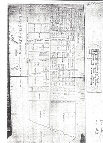
![Map, Plan of Town Allotments Bacchus Marsh [1891-1897]](/media/collectors/5e461d8021ea67224c82f2a1/items/66acc1c90c778f9f64a3daec/item-media/66acc3990c778f9f64a3e09b/item-fit-380x285.jpg) Bacchus Marsh & District Historical Society
Bacchus Marsh & District Historical SocietyMap, Plan of Town Allotments Bacchus Marsh [1891-1897]
This plan of town allotments in Lerderderg Street and Bennett Street also includes the location of many of the buildings, shops, businesses and houses which were present in the retail and business area of Bacchus Marsh in the 1890s. The precise date of the plan is not known but it must be sometime between 1891 and 1897. The Post Office and the Wesleyan Church are both shown on this plan. Both of these were constructed in 1890. The plan does not show the Baptist Church in Main Street which was constructed in 1898. Hence the date is sometime between 1891 and 1897.This plan of Bacchus Marsh is one of the most detailed visual representations of the location of shops, businesses and houses in the central part of Bacchus Marsh. It provides very precise locations of most of the shops and houses in the town in the 1890s. A single page paper plan showing allotments of land fronting Lerderderg and Bennett Street. Buildings, businesses and houses along most of the streets are identified by hand written annotations. Streets identified on plan: Lerderderg Street - Bennett Street - Main Street - Gell Street - Young Street - Graham Street. Physical boundaries of the map are: North border - Lerderderg Street - South border - Main Street - West border Gell Street - East border - Young Street. The plan is pasted into a bound volume containing 76 maps or plans in total. bacchus marsh victoria maps, shops bacchus marsh