Showing 696 items matching " forest creek"
-
 Whitehorse Historical Society Inc.
Document, Fire Insurance Policy, 10/12/1909 12:00:00 AM
Fire insurance policy certificate issued to Martha Edwards for a building in Husband Road Tunstall, 10 December 1909, by Atlas Assurance Company Limited.Fire insurance policy certificate issued to Martha Edwards for a building in Husband Road Tunstall, 10 December 1909, by Atlas Assurance Company Limited.Fire insurance policy certificate issued to Martha Edwards for a building in Husband Road Tunstall, 10 December 1909, by Atlas Assurance Company Limited.edwards, martha, atlas assurance company limited, insurance, husband road, forest hill, no. 42, husband road, tunstall -
 Whitehorse Historical Society Inc.
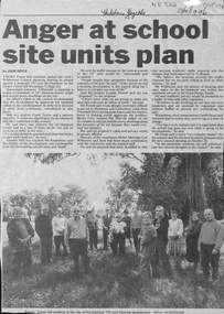
Newspaper - Article, Anger at school site plan, 23/10/1996
... Whitehorse Historical Society Inc. 2-10 Deep Creek Road ...Article in Whitehorse Gazette 28/10/1996 about objections by neighbouring residents to development of the Forest Hill Secondary College site.forest hill secondary college, mahoneys road, forest hill, canterbury road, thornhill drive, oscar, geoff, land subdivision -
Whitehorse Historical Society Inc.
Article, 'Weary' recalls the war, 1985
Sir Edward 'Weary' Dunlop spoke of his wartime experiences to Forest Hill Rotarians (photo)Sir Edward 'Weary' Dunlop spoke of his wartime experiences to Forest Hill Rotarians (photo)Sir Edward 'Weary' Dunlop spoke of his wartime experiences to Forest Hill Rotarians (photo)world war 1939-1945, dunlop, edward sir, rogers, john, haig, jack, rotary club of forest hill -
 Whitehorse Historical Society Inc.
Document, Canterbury Road Tunstall, 29/01/19?5
Photocopy of letter to the Commercial Bank, Prahran re land and property valuation occupied by Mr Sliegner, north side of Canterbury Road, Tunstall (Now Forest Hill) close to Springvale Road. Land 2.5 acres with villa and out buildings.land values, sliegner (mr), canterbury road, forest hill, c. husband (estate agent) -
Whitehorse Historical Society Inc.
Newspaper, Local Advertiser Mitcham Nunawading, 1963
Photocopy of issue dated 25 September 1963Photocopy of issue dated 25 September 1963Photocopy of issue dated 25 September 1963brentford square shopping centre, forest hill, city of nunawading, schwerkolt cottage -
Whitehorse Historical Society Inc.
Article, Push for hard waste disposal contractor|Cans success, 1993
Outside contractors to replace council staff in collecting Nunawading's indestructible rubbish.| Nunawading Apex Club's aluminium recycling depot at the Nunawading Civic Centre proved very successful.Outside contractors to replace council staff in collecting Nunawading's indestructible rubbish.| Nunawading Apex Club's aluminium recycling depot at the Nunawading Civic Centre proved very successful. A new operation will open at Forest Hill Chase.Outside contractors to replace council staff in collecting Nunawading's indestructible rubbish.| Nunawading Apex Club's aluminium recycling depot at the Nunawading Civic Centre proved very successful.city of nunawading, garbage collection, recycling, hawke, graham, apex club nunawading, forest hill chase -
Whitehorse Historical Society Inc.
Article, Lodge is losing its fight for survival, 1994
Forest Hill's Strathdon lodge looks set to lose its two year battle for survival.Forest Hill's Strathdon lodge looks set to lose its two year battle for survival.Forest Hill's Strathdon lodge looks set to lose its two year battle for survival.strathdon community, aged people -
Whitehorse Historical Society Inc.
Document, Nunawading City, 1946
Photocopy of two double pages from a Municipal Directory for 1946 giving details of the City of Nunawading in its first year.Photocopy of two double pages from a Municipal Directory for 1946 giving details of the City of Nunawading in its first year. Includes list of councillors and staff and descriptions of the suburbs included.Photocopy of two double pages from a Municipal Directory for 1946 giving details of the City of Nunawading in its first year.city of nunawading, directories, councillors, council staff, blackburn, forest hill, mitcham, nunawading, vermont -
 Whitehorse Historical Society Inc.
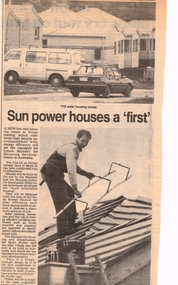
Article, Sun power houses a 'first', 17/05/1989 12:00:00 AM
first solar village in AustraliaA newspaper article on the first solar village in Australia, built in Nunawading. It has been designed specifically to meet Australian weather conditions.first solar village in Australiaresidential development, mock street forest hill, solar energy council, pullen, barry -
 Whitehorse Historical Society Inc.
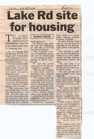
Article, Lake Rd Site for Housing, 8/04/1992 12:00:00 AM
Lake Rd Site for Housing.An article in the Nunawading Gazette on an objection by Mark Delaney on the traffic flow and hazards associated with the proposed development of land on the former Forest Hill Residential Kindergarten land.Lake Rd Site for Housing.land subdivision, forest hill residential kindergarten, lake road, forest hill, jean street, phillips, bruce, delaney, mark, glen valley road -
Whitehorse Historical Society Inc.
Document, Lawrence Wreford Chandler, c1975
Extract from the Chandler Family history about Lawrence Wreford Chandler who developed flower gardens and whose widow eventually subdivided the land in Blackburn South between Wreford Road and Orchard Grove.Extract from the Chandler Family history about Lawrence Wreford Chandler who developed flower gardens and whose widow eventually subdivided the land in Blackburn South between Wreford Road and Orchard Grove. Also notes about two children Margaret and Joan.Extract from the Chandler Family history about Lawrence Wreford Chandler who developed flower gardens and whose widow eventually subdivided the land in Blackburn South between Wreford Road and Orchard Grove. chandler, lawrence wreford, chandler, wref, chandler, jessie, wreford road, blackburn south, orchard grove, blackburn south, canterbury road, blackburn south, chandler, joan, gedye, joan, swan hardware, forest hill, chandler, margaret mitchell, adams, margaret mitchell, flower growing -
 Whitehorse Historical Society Inc.
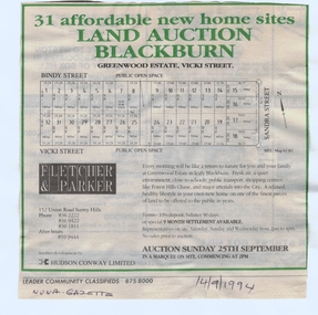
Document, Greenwood Estate, 14/09/1994 12:00:00 AM
subdivision of former Wunderlich site iAdvertisement for auction of 'Greenwood Estate', 31 sites, Vicki Street, Vicki Street 'Blackburn' (now Forest Hill), 25 September 1994. Agent: Fletcher & Parker. In Nunawading Gazettesubdivision of former Wunderlich site ibindy street, forest hill, vicki street, sandra street, greenwood estate, auctions -
Whitehorse Historical Society Inc.
Article, Linda's career growing as fast as her plants, 1985
History of Linda Connolly and her new appointment as Parks Officer of the City of Nunawading Horticultural Centre.History of Linda Connolly and her new appointment as Parks Officer of the City of Nunawading Horticultural Centre.History of Linda Connolly and her new appointment as Parks Officer of the City of Nunawading Horticultural Centre.local government, connolly, linda, horticultural centre, forest hill, city of nunawading -
Whitehorse Historical Society Inc.
Article, Beatrice or Valley, 1967
Article in Nunawading Gazette re objections to the name Beatrice Court. Objectors would like the name changed to Valley Court, Forest Hill.[actually in Blackburn]Article in Nunawading Gazette re objections to the name Beatrice Court. Objectors would like the name changed to Valley Court, Forest Hill.[actually in Blackburn]Article in Nunawading Gazette re objections to the name Beatrice Court. Objectors would like the name changed to Valley Court, Forest Hill.[actually in Blackburn]street names, city of nunawading, beatrice court, blackburn, peak court, blackburn -
 Whitehorse Historical Society Inc.
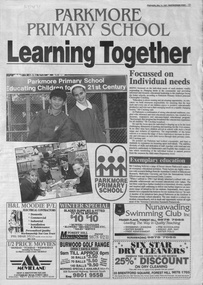
Newspaper - Article, Parkmore Primary School, 14/05/1997
Article on Parkmore Primary School, Jolimont Road, Forest Hillparkmore primary school, no. 4881, primary schools -
 Whitehorse Historical Society Inc.
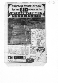
Document, Mount Pleasant Estate, ca 1953
Plan and advertisements for 'Mt Pleasant Estate' Forest Hill. 381 allotments. Agent: T. M. Burke Pty Ltd.land sales, mount pleasant estate, rooks road, vermont, canterbury road, forest hill, alwyn street, mitcham, diosma crescent, nunawading, nott street, eugenia street, abelia street, weigela court, nandina street, grevillea court, azalea street, felicia grove, beech street -
Whitehorse Historical Society Inc.
Document, Invitation to official launch of 'Windows of Nunawading', 1/12/1990 12:00:00 AM
Invitation from Mayor Cr Bruce Atkinson to the official launch of 'Windows of Nunawading'[sic] to be held at Forest Hill Chase Shopping Centre on Saturday 8 December 1990 at 10.30 AMInvitation from Mayor Cr Bruce Atkinson to the official launch of 'Windows of Nunawading'[sic] to be held at Forest Hill Chase Shopping Centre on Saturday 8 December 1990 at 10.30 AMInvitation from Mayor Cr Bruce Atkinson to the official launch of 'Windows of Nunawading'[sic] to be held at Forest Hill Chase Shopping Centre on Saturday 8 December 1990 at 10.30 AMcity of nunawading, sydenham, diane. windows on nunawading -
Whitehorse Historical Society Inc.
Article, Depots to merge, 1995
Whitehorse Council is considering selling the Nunawading Council depot and upgrading the Box Hill depot to cater for the new amalgamated municipality.Whitehorse Council is considering selling the Nunawading Council depot and upgrading the Box Hill depot to cater for the new amalgamated municipality. But Nunawading is likely to retain its Horticultural Centre in Forest Hill.Whitehorse Council is considering selling the Nunawading Council depot and upgrading the Box Hill depot to cater for the new amalgamated municipality.local government, city of whitehorse, council depots, amalgamations -
Whitehorse Historical Society Inc.
Article, Cloud over orchard, 1996
City of Nunawading's Bicentennial Orchard in Forest Hill future hangs in the balance.City of Nunawading's Bicentennial Orchard in Forest Hill future hangs in the balance. Whitehorse Council has decided to appeal to the 'experts' to devise a long-term strategy to decide the orchard's future.City of Nunawading's Bicentennial Orchard in Forest Hill future hangs in the balance. local government, city of nunawading, bicentennial orchard, city of whitehorse -
Whitehorse Historical Society Inc.
Letter - Correspondence, Poultry Farms, 20/04/2002
Letter from Frank Eckermann to Valda Arrowsmith accompanying slides of Forest Hill (NP 2751 - 2774)Letter from Frank Eckermann to Valda Arrowsmith accompanying slides of Forest Hill (NP2751 - 2774)Letter from Frank Eckermann to Valda Arrowsmith accompanying slides of Forest Hill (NP 2751 - 2774)poultry farms, forest hill, mount pleasant road, forest hill, no 149, eckermann family -
 Whitehorse Historical Society Inc.
Newspaper - Article, Forest Hill Secondary College Nunawading Campus Site
Progress in development of medium density housing project on former site of Forest Hill Secondary College Nunawading Campusblackburn lake sanctuary;, terrara road, vermont -
Whitehorse Historical Society Inc.
Document, City of Nunawading Administrative and Engineering Committee, 1991
Notice of agenda of a meeting to be held in Committee Room A, Civic Centre, Nunawading, 3 Jul 1991.Notice of agenda of a meeting to be held in Committee Room A, Civic Centre, Nunawading, 3 Jul 1991. Major item re Vermont Reserve.Notice of agenda of a meeting to be held in Committee Room A, Civic Centre, Nunawading, 3 Jul 1991. city of nunawading, dilley, warwick, cooper, les, allan, peter, atkinson, bruce, smith, d, vermont reserve, vermont primary school, no. 1022, heritage week 1991, councillors, vermont cricket club, forest hill cricket club -
Whitehorse Historical Society Inc.
Newspaper, Nunawading Gazette, 9/08/1972 12:00:00 AM
Special centenary issue of the Nunawading Gazette.Special centenary issue of the Nunawading Gazette.Special centenary issue of the Nunawading Gazette.nunawading gazette, nunawading, box hill, blackburn, mitcham, forest hill, vermont -
Whitehorse Historical Society Inc.
Pamphlet, The Road closure issue in Blackburn, 1975
City of Nunawading report featuring a Task Force finding and the formation of the Blackburn Residents Road Closure Protest Group in 1975City of Nunawading report featuring a Task Force finding and the formation of the Blackburn Residents Road Closure Protest Group in 1975City of Nunawading report featuring a Task Force finding and the formation of the Blackburn Residents Road Closure Protest Group in 1975roads and streets, city of nunawading, blackburn residents road closure protest group, naughton grove, blackburn, jeffery street, blackburn, alandale road, blackburn, wellington avenue, blackburn, gordon crescent, blackburn, blackburn road, blackburn, wolseley crescent, blackburn, mckinnon street, blackburn, forest road, blackburn -
Whitehorse Historical Society Inc.
Map, Today's map of Mitcham, Nunawading, Blackburn, 1957
Folded detailed map of Mitcham, Nunawading, BlackburnFolded detailed map of Mitcham, Nunawading, BlackburnFolded detailed map of Mitcham, Nunawading, Blackburnmaps, mitcham, nunawading, blackburn, burwood east, forest hill, vermont -
Whitehorse Historical Society Inc.
Article, City to have resource centre, 1992
A resource centre to be established by City of Nunawading at Forest Hill Chase.A resource centre to be established by City of Nunawading at Forest Hill Chase.A resource centre to be established by City of Nunawading at Forest Hill Chase.city of nunawading, resource centres, forest hill chase, edwards, margaret -
Whitehorse Historical Society Inc.
Article, Arts Council has a big task, 1976
Recruits required to join the Arts Council of the City of NunawadingRecruits required to join the Arts Council of the City of Nunawading which has a big task to decide which groups to support within the municipality.Recruits required to join the Arts Council of the City of Nunawading arts council of the city of nunawading, city of nunawading, levings, brian, pearson, ella, amos, brian, utassy, belinda, mitchell, bob, mitchell, ray, forest hill shopping centre traders association -
Whitehorse Historical Society Inc.
Document, Historical treasure hunt, 1/05/1970 12:00:00 AM
Details and entry form for an 'Historical Treasure Hunt' competition held by Forest Hill Shopping Centre Traders Association, May 1970.Details and entry form for an 'Historical Treasure Hunt' competition held by Forest Hill Shopping Centre Traders Association, May 1970. Includes list of prize winners and information about their entries.Details and entry form for an 'Historical Treasure Hunt' competition held by Forest Hill Shopping Centre Traders Association, May 1970.forest hill shopping centre traders association, competitions, nunawading historical society, wilkins, susan, inglis, paul, mcdonald, andrew, blackwell, syephen, hart, wendy, donovan, leanne -
 Whitehorse Historical Society Inc.
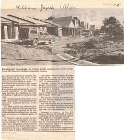
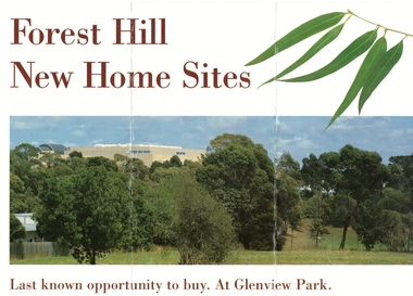
Document, Forest Hill new home sites, 1/02/1995 12:00:00 AM
Advertising 22 new home sites off Glen Valley Road, near the corner of Springvale and Canterbury Roads, Forest HillBrochure advertising 22 new home sites off Glen Valley Road, near the corner of Springvale and Canterbury Roads, Forest Hill on the former Forest Hill Primary School site (closed 1993).Advertising 22 new home sites off Glen Valley Road, near the corner of Springvale and Canterbury Roads, Forest Hillland subdivision, glenview park, glen valley road, forest hill, pratico court, springvale road, fletcher and parker, forest hill primary school -
Whitehorse Historical Society Inc.
Document, Forest Hill State School history up till 1968, 1968
A brief history of Forest Hill State School from its inception to 1968.A brief history of Forest Hill State School from its inception to 1968. Also includes some information on early Forest HillA brief history of Forest Hill State School from its inception to 1968.forest hill state school no. 4251, forest hill