Showing 183 items
matching land surveyors
-
 Federation University Historical Collection
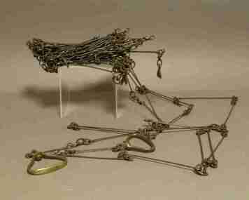
Instrument - Survey Chain, Chesterman, Gunter's Survey Chain
Before metric measurement was introduced land was measured in chains and links. The chain was a precision part of a surveyor's equipment. It required frequent calibration, yet needed to be sturdy enough to be dragged through rough terrain for years. A standard survey chain is 66 feet (or 20.117m) long and made up of 100 links. Each link is 7.92 inches (approximately 201mm) long, measured from the inside of the loop. The handles are for tensioning the chain in use, they are not part of the length of the chain. In pre-metric units, there were 80 chains to 1 mile (equals 1.609km) This surveyor’s chain has an 8-inch link pitch, with markers at 10 link intervals. This metal surveyor’s chain (or Gunter's Chain) has an 8-inch link pitch, with markers at 10 link intervals, and handles at either end. A Surveyor’s Chain was 66 feet long, and made up of 100 links connected by two rings. A link in measurement includes the two rings at each end. gunter's chain, survey chain, surveyor s chain, perch, rood, surveying -
 Ringwood and District Historical Society
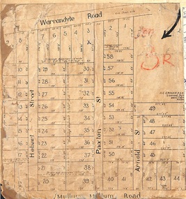
Map, Residential Subdivision Allotment Layout on Mullum Mullum Road, Hobart Street, Paxton Street, Arnold Street and Warrandyte Road, Ringwood, Vic. circa 1920
One of 3 unrelated land subdivision maps on cardboard backing.H.C. Crouch, Licensed Surveyor, 443 Lt Collins Street, Melbourne. -
 Ringwood and District Historical Society
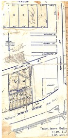
Map, Partially trimmed copy of a retail and residential auction advertisement, Ringwood, Vic. - 1926
One of 3 unrelated land subdivision maps on cardboard backing. Numbered allotments on Nelson Street, Seymour Street and Whitehorse Road, Ringwood.W.J. Bonwick, Licensed Surveyor, Phone WU4830. Location map also includes Bourke Street, Bond Street, Charter Street, Ringwood Street, and Shops and Market sites in Ringwood.