Showing 588 items
matching mansion
-
 Tatura Irrigation & Wartime Camps Museum
Domestic object - Spoons in display case
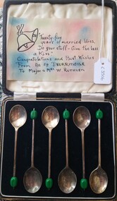
Given to Major and Mrs Rathven on their 25th wedding anniversary from the people he worked with at Dhurringile Mansion during WW2.Black leather case with gold embossed patterns around top edge of lid. Two brass decorative catches on front. Inside of the top of the case is lined with cream satin. The base is lined with black velvet. Six silver plated spoons with a green enamel bead on tip sit on the velvet base. Handwritten note loose in the top."Twenty five years of married bliss. Do your stuff - give the misses a kiss". Congratulations and best wishes from all at Dhurringile. To Major and Mrs W Rathvenmajor rathven, mrs rathven, 25th wedding anniversary, dhurringile mansion, silver plate spoons -
 Camberwell Historical Society
Photograph (item) - Still image, Raheen inkjet photograph
camberwell, raheen, mansion, kew -
 Robin Boyd Foundation
Document - Script, Robin Boyd, The Flying Dogtor. Episode 31 Crafty Returns, 1963
Crafty Carson Carpetbag escaped from the police after the Flying Dogtor had arrested him, and he slipped back home to the old shearing shed. There he found a message from the Redback family. They had gone to Mangrove Mansion, an old deserted homestead. Meanwhile, the bush children were exploring around Mangrove Mansion following a message they received from their friend, The Flying Dogtor.The Flying Dogtor" series was broadcast on Australian Television Network (later becoming the Seven Network) between February and April 1964 (see item D254 for schedule).Typewritten, carbon copy, foolscap, 2 pagesthe flying dogtor, robin boyd, crawford productions, manuscript -
 Kew Historical Society Inc
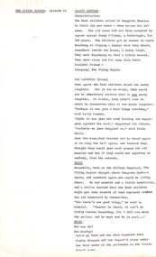
Photograph - Staircase of 'Tara Hall', Studley Park Road, Marc Strizic (attrib), c.1960
'Lost Glories: a memorial to forgotten Australian buildings' was published by David Latta in 1986. It tells the story of a number of significant Australian buildings that had previously been demolished. A chapter in the book was devoted to Goathland, later known as Tara Hall. To supplement the text, he sourced photographs from a range of suppliers, chiefly the Royal Women's Hospital which had once owned Tara Hall, but had sold it in 1960. This is one of the photographs donated to KHS by the author. The Staircase at Tara Hall, circa 1957. An angled view of the main hallway and staircase of Tara Hall (previously named Byram, Goathland and Lowan). To the right of the staircase in this Studley Park Road mansion, a large inglenook fireplace was located, which was surrounded by stucco decoration. The latter was a characteristic of E. G. Kilburn’s late style.Typed inscription on reverse: "The Staircase at Tara Hall. Above the ornate fireplace is the legend 'Come When You Mind, A Welcome Find'. (Royal Women's Hospital, Melbourne)." byram, goathland, tara hall, lowan, studley park (kew), george ramsden, sir malcolm mceacharn, edward george kilburn (architect), studley park road (kew) -
 Kew Historical Society Inc
Plan, Sydney Arnold Best & Co, Field Place, Kew, c.1929
Pru Sanderson, in her groundbreaking ‘City of Kew Urban Conservation Study : Volume 2 - Development History’ (1988), summarised the periods of urban development and subdivisions of land in Kew. The periods that she identified included 1845-1880, 1880-1893, 1893-1921, 1921-1933, 1933-1943, and Post-War Development. These periods were selected as they represented periods of rapid growth or decline in urban development. An obvious starting point for Sanderson’s groupings involved population growth and the associated economic cycles. These cycles also highlighted urban expansion onto land that was predominantly rural, although in other cases it represented the decline and breakup of large estates. A number of the plans in the Kew Historical Society’s collection can also be found in other collections, such as those of the State Library of Victoria and the Boroondara Library Service. A number are however unique to the collection.The Kew Historical Society collection includes almost 100 subdivision plans pertaining to suburbs of the City of Melbourne. Most of these are of Kew, Kew East or Studley Park, although a smaller number are plans of Camberwell, Deepdene, Balwyn and Hawthorn. It is believed that the majority of the plans were gifted to the Society by persons connected with the real estate firm - J. R. Mathers and McMillan, 136 Cotham Road, Kew. The Plans in the collection are rarely in pristine form, being working plans on which the agent would write notes and record lots sold and the prices of these. The subdivision plans are historically significant examples of the growth of urban Melbourne from the beginning of the 20th Century up until the 1980s. A number of the plans are double-sided and often include a photograph on the reverse. A number of the latter are by noted photographers such as J.E. Barnes.An unnamed subdivision in Studley Park including five lots for sale in Studley Park Road, Highfield Grove and Tara Avenue. Unidentified on the plan, but clearly existing, are the Henty family mansion of Field Place and Tara Hall in Studley Park Road. The first attempted subdivision of Tara Hall was advertised in 1927 in which Lots 5, 6 and 7 in this plan were also advertised. Unusually, Lot 2 in Studley Park Road was created from the northern part of the Henty mansion, rather than Tara Hall. In the subdivision, lots were advertised at varying prices, with the highest price for land being Lot 2 in Studley Park Road. The plan notes that only one villa is to be allowed on each allotment.subdivision plans - kew, field place subdivision -- studley park – kew (vic.), highfield grove – kew (vic.), tara avenue – kew (vic.) -
 Kew Historical Society Inc
Photograph - Yarra River, Kew, 1925
Henry Beater Christian (1886-1962) , was a descendant of one of the earliest settler families in Kew. Employed at the Kew Asylum as a 'public servant', he was a skilled amateur photographer, photographing numerous scenes in Kew and on his travels around Victoria. The majority of his photographs date from 1916 to 1929. His finest photographs are housed in two photograph albums. Digital copy of a photograph from page 3 of the 47-page photograph album containing 261 gelatinous silver images, loaned by Diane Washfold with permission given to digitise and hold a copy in our collection. A photograph of a stretch of the Yarra River at Kew. In the distance rises J Lewis Carnegie's mansion 'Carnsworth' in Stawell Street."Yarra Rvr / Kew / 1925"henry beater christian (1886-1962), landscape photography, kew (vic.) — yarra river, christian-washfold collection, photograph albums, carnsworth -
 Kew Historical Society Inc
Photograph - 'La Verna' (formerly 'Heathfield'), 39 Sackville Street, 1988
Documentary evidence records that in 1888 Henry Eeles, stationer, was the first owner and occupier of this two-storey mansion. At that date the building was given an N.A.V.of £275 and Eeles was recorded as the owner of the house until at least 1910, when the thirteen-roomed mansion attracted an N.A.V. of £190. The house is quite typical of time, and it bears a remarkable resemblance to 3 Molesworth Street, the architect of which has not been established. (Kew Conservation Study, 1988)Colour photographic positive of one of 'La Verna' (formerly 'Heathfield'). The house is two storeyed and clad in render. It is ltaIianate in styling and is dominated by a two storeyed loggia that spans two facades. At ground floor level it has rounded arches supponed on cast iron colonettes, and above, has colonettes that support stilted segmental arches. (Kew Conservation Study, 1988)heathfield -- sackville street --- kew (vic), la verna -- sackville street -- kew (vic.) -
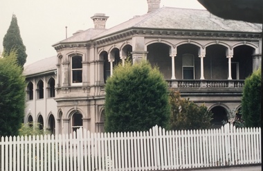
Tatura Irrigation & Wartime Camps Museum
Booklet, Dhurringile, 1845-1970, 1970
History of Dhurringile, The Mansion. Also of other owners and occupiers, including a prison camp during WW2, Presbyterian Boys' Training farm and Rehabilitation prison.Burgandy back and binding, beige front, clear plastic coverhistory of dhurringile, bossence w, tatura, "tatura" by wh bossence, presbyterian boys' training farm, presbyterian boys' rehabilitation prison -
Tatura Irrigation & Wartime Camps Museum
Documents, Heritage Victoria, 06.09.2005
Letter in answer to a query as to status of Camp 13. Reports from Heritage Victoria describing Dhurringile Mansion and Camp 13 POW Camp site.Correspondence and reports. -
Bialik College
Photograph (Item) - Students in costume as part of Annie production 1996
Annie musical, 1996 at Bialik College. Photograph is the result of an offsite photograph session at a mansion with the students in costume. Please contact [email protected] for permissions. musical, judaism, theatre, 1990s, bialik college -
Hume City Civic Collection
Print, 1993
The coloured print features the railway bridge which spans the Rupertswood Cutting and is north of the Sunbury Railway station. The Rupertswood Mansion is also featured in the distance.A coloured print with a white border of a rural landscape in a valley featuring a bridge in the middle distance and a large building in the distance.A.Rafferty 93bridges, rupertswood cutting, rupertswood, railways -
Kew Historical Society Inc
Archive (Sub-series) - Subject File, Findon (Kew), 1958
Various partiesReference, Research, InformationSecondary Values (KHS Imposed Order)Subject file on Findon, an early mansion in Studley Park and its owners including the Hon Henry “Money” Miller. The two main items in the file are an extract from Victoria and Its Metropolis on Miller and an article on the organ that was once in the house and according to an article on the Organ Trust website, currently in the Wesley Uniting (formerly Methodist Church) in Box Hill. kew (vic) - history, findon, henry "money" miller, organs - victoriakew (vic) - history, findon, henry "money" miller, organs - victoria -
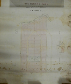 Bendigo Historical Society Inc.
Plan - MARKS COLLECTION: PLAN OF G. LANSELL'S GOVERNOR'S PARK, TOORAK
Plan (tightly rolled) drawn on heavy paper mounted on fabric. On top of plan printed 'Governor's Park Toorak, late Vice-Regal Estate, the property of G. Lansell Esq' On top of plan Yarra River, on bottom Toorak Road, Plan shows subdivision, in centre of which is drawn outline of 8 acres containing the 'Mansion and Grounds'.bendigo, hospital -
 St Kilda Historical Society
Photograph, Eildon, c. 1890
Photograph of Eildon mansion, fa�ade facing the bay. J.L Currie with walking cane, dog and two workers , including Don Taggarts grandfather in the foregroundblack and white photograph, unmounted, original, good condition"Eildon".Grey St St Kilda.. Was the home of .J.L.Currie.F.R.S. Reading Left to Right:-Unknown. John Taggart (my Grandfather)& J.L.Currie. (My Granfather was gardner at "Eildon"). J.L. Currie was Western District Pastoralist. Taken in 1890's. Don Taggart -
Tatura Irrigation & Wartime Camps Museum
Document, Franz Heinrich Dahm, 2014
Account in German, written by Dahm, of his capture and imprisonment in Dhurringile POW Camp Brought to Tatura by Dahm's daughter while on a visit to Dhurringile Mansion 2014.Red plain covered,black bound printed document of 202 pages.german afrika korps, .dhurringile pow camp -
 Tatura Irrigation & Wartime Camps Museum
Photograph - colour, Reunion
Reunion in Nov. 10th. 2001 of boys brought out to Australia from the U.K. in the 1950's by the Presbyterian Church, to the Dhurringile Training Farm at Dhurringile Mansion.photograph, people -
 Kew Historical Society Inc
Plan - Subdivision Plan, 6 Choice Residential Allotments: East Kew, 1932
Prue Sanderson, in her groundbreaking ‘City of Kew Urban Conservation Study : Volume 2 - Development History’ (1988), summarised the periods of urban development and subdivisions of land in Kew. The periods that she identified included 1845-1880, 1880-1893, 1893-1921, 1921-1933, 1933-1943, and Post-War Development. These periods were selected as they represented periods of rapid growth or decline in urban development. An obvious starting point for Sanderson’s groupings involved population growth and the associated economic cycles. These cycles also highlighted urban expansion onto land that was predominantly rural, although in other cases it represented the decline and breakup of large estates. A number of the plans in the Kew Historical Society’s collection can also be found in other collections, such as those of the State Library of Victoria and the Boroondara Library Service. A number are however unique to the collection.Subdivision plans are historically important documents used as evidence of the growth of suburbs in Australia. They frequently provide information about when the land was sold on which a built structure was subsequently constructed as well as evidence relating to surveyors and real estate and financial agents. The numerous subdivision plans in the Kew Historical Society's collection represent working documents, ranging from the initial sketches made in planning a subdivision to printed plans on which auctioneers or agents listed the prices for which individual lots were sold. In a number of cases, the reverse of a subdivision plan in the collection includes a photograph of a house that was also for sale by the agent. These photographs provide significant heritage information relating house design and decoration, fencing and household gardens.The mansion Woodlands in Harp Road, East Kew suffered the death of a thousand cuts. In its case, the cuts were subdivisions. Previous subdivisions of the mansion and its grounds were given titles such as ‘The Eastlawn Estate’ (MAP.0055), whereas at the end, the subdivision called it as it was, naming itself the ‘final section of the Woodlands Estate’ when it was put up for auction in 1932. The emphasis in the promotion of the subdivision was that it provided purchasers with splendid opportunities ‘to build modern homes in select, well established modern surroundings’. As with other subdivisions in the interwar period, transport links were emphasised. The six residential lots cut Woodlands off from Harp Road. When the vendor, Louisa Rachel Preston Hill, was to die at Woodlands in 1937 aged 86 her address was given as Normanby Road.subdivision plans - kew, woodlands estate -
 Glen Eira Historical Society
Album - Album page, Royston, Kooyong Road, Circa 1972
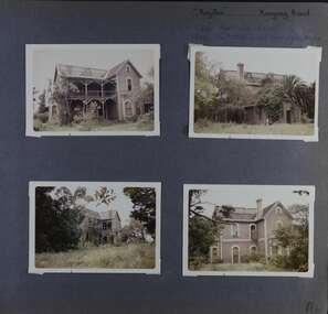
This photograph is part of the Caulfield Historical Album 1972. This album was created in approximately 1972 as part of a project by the Caulfield Historical Society to assist in identifying buildings worthy of preservation. The album is related to a Survey the Caulfield Historical Society developed in collaboration with the National Trust of Australia (Victoria) and Caulfield City Council to identify historic buildings within the City of Caulfield that warranted the protection of a National Trust Classification. Principal photographer thought to be Trevor Hart, member of Caulfield Historical Society. Most photographs were taken between 1966-1972 with a small number of photographs being older and from unknown sources. All photographs are black and white except where stated, with 386 photographs over 198 pages. Vol 1 of 4 "Caulfield's Heritage" p34 states that this mansion was demolished in 1972.Page 114 of Photograph Album with four colour photographs (landscape) of different views of Royston in its garden.Handwritten: "Royston" Kooyong Road / 240 KOOYONG ROAD / 1939 - SLATTER - MISS MAY EDITH ALICE. [top right] / 114 [bottom right]trevor hart, caulfield north, kooyong road, 1860's, villa residence, victorian, mansion, ornamented corner stones, royston, renwick, curved windows, timber verandahs, return verandahs, bay windows, may edith alice slatter, may slatter, balconies, polychrome bricks, abandoned buildings -
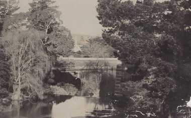 Sunbury Family History and Heritage Society Inc.
Photograph, c 1910
The photograph was taken from the iron bridge on the Rupertswood Estate. The tower of the Rupertswood Mansion can be seen in the distance. The Eadie family were business people and millers in Sunbury.A post card featuring a dark sepia image of a creek with a large house in the distance. There is a hand written message on the back.Written on the back: Dear old boy Many happy returns of the 8th. I . . . . . . . . . . . . making the . . . .Yours ever Will. Iron bridge at Rupertswood. Mr Hal Eadie Dannevirke NZ.rupertswood mansion, jacksons creek -
 Warrnambool and District Historical Society Inc.
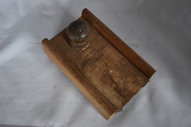
Functional object - Knife and fork cleaner, Levin & Co Pty Ltd, Early 20th century
This is a simple household labour-saving device. The box was fitted to the end of the table and knife polish was sprinkled on the cloth inside. The knife was then placed in the centre of the box and clamped in tightly. The knife was then pulled backwards and forwards several times (three seconds was the suggested time) and the object was then deemed to be polished. All households had cutlery of some sort and many had good silver pieces that were meant to be kept in a sparkling polished condition. This cleaner would have assisted those in a household assigned to the care of the cutlery. These would have included the women of the household, the children or domestic employees. This item is retained as an interesting example of a household labour-saving device from 100 years ago. This is a circular wooden box with an extra piece at one end of the base and a sliding top lid with a wooden knob. The lid lifts up and the inside of the box and the lid is covered with rough cloth. Some of this cloth has rotted away. The top of the lid has a printed label pasted on. This is torn and soiled. ‘Patent The Magic Knife and Fork Cleaner’ ‘I am handy and useful where’r I am used, To clean knives and forks brightly I never refuse, In mansion or cottage to both I do go, So buy me, and try me, my worth you will know.’ household devices, history of warrnambool -
 Tennis Australia
Sepia, Digital print, Circa 1895, Circa 2001
An e.21st century digital print on canvas, of an original l.19th century sepia photographic print. Image features a group of men, women and children, sitting on, around, or standing above a flight of steps, in front of a large mansion. Most of the participants are holding tennis racquets. Materials: Canvas/Cotton, Ink, Wood, Metal, Paper, Paint, Linentennis -
 Tennis Australia
Poster, Advertisement, Circa 1885, Circa 2000
A digital print of an original 1880's advertisement, depicting a mixed doubles game of tennis, played on a lawn in front of a mansion, within the grounds of an estate. Inscription: ESTABLISHED 1856/PROSSER & SONS/LAWN TENNIS RACKET & BALL./MANUFACTURERS/200 PENTONVILLE ROAD/LONDON/ARMITAGE & IBBETSON, LITHO. BRADFORD. Materials: Paper, Ink, Cardboard, Glass, Metal, Foamcoretennis -
 Kew Historical Society Inc
Plan - Subdivision Plan, Forres Estate, East Kew, 1919, 1919
Pru Sanderson, in her groundbreaking ‘City of Kew Urban Conservation Study : Volume 2 - Development History’ (1988), summarised the periods of urban development and subdivisions of land in Kew. The periods that she identified included 1845-1880, 1880-1893, 1893-1921, 1921-1933, 1933-1943, and Post-War Development. These periods were selected as they represented periods of rapid growth or decline in urban development. An obvious starting point for Sanderson’s groupings involved population growth and the associated economic cycles. These cycles also highlighted urban expansion onto land that was predominantly rural, although in other cases it represented the decline and breakup of large estates. A number of the plans in the Kew Historical Society’s collection can also be found in other collections, such as those of the State Library of Victoria and the Boroondara Library Service. A number are however unique to the collection.Subdivision plans are historically important documents used as evidence of the growth of suburbs in Australia. They frequently provide information about when the land was sold on which a built structure was subsequently constructed as well as evidence relating to surveyors and real estate and financial agents. The numerous subdivision plans in the Kew Historical Society's collection represent working documents, ranging from the initial sketches made in planning a subdivision to printed plans on which auctioneers or agents listed the prices for which individual lots were sold. In a number of cases, the reverse of a subdivision plan in the collection includes a photograph of a house that was also for sale by the agent. These photographs provide significant heritage information relating house design and decoration, fencing and household gardens.An annotated subdivision plan for the Forres Estate, Kew East. The estate was advertised in 1919, the Melbourne Auctioneers being represented locally by Henry Kellett, Estate Agent of High Street, Kew. The name of the estate was derived from the mansion (demolished 2016) of the same name in Normanby Road, which was at one stage owned by the Mayor of Kew, Cr. J. S. Were.subdivision plans - kew, forres estate, argyle road, simpson street, hubert street, normanby road -
 St Kilda Historical Society
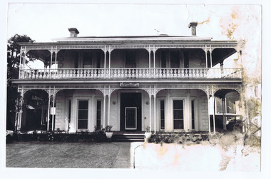
Photograph, The Age newspaper, Linden, 14/04/1972
Picture of late 19th century double storey, double fronted mansion with wrought iron pillars and balcony lace work on upper ballistrade. Built for Moritz Michaelis in 1870Michaleis Moritz, black and white photograph, unmounted, poor condition with water damage to right side.Linden 14-4-1972 Age photo 1758/59' -
Tatura Irrigation & Wartime Camps Museum
Photograph - copy, D. Clark, Tatura Cricket Team 1951-52, 1989 copy
Copy of photograph of Tatura Cricket team 1951.52. Names on back. Taken at Dhurringile, next to Dhurringile Mansion. Land donated by Jack Lowry for Cricket Oval. Original 260.1.Black and white copy of photograph of Tatura Cricket Team.on back: Tatura Cricket Team. names of team -
 Greensborough Historical Society
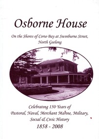
Book, Cheryl Scott, Osborne House - celebrating 150 years - 1858-2008, 2008c
Originally built as a squatter's mansion in North Geelong 1858, Osborne House is currently owned by Geelong City Council and is used for community purposes. This is a history of the house and its various uses.79 p. paperback printed in black, illus.geeelong, osborne house -
Canterbury History Group
Pamphlet - Frognall 1888 - 1989, 1989
Brief history of Frognall prepared by the Camberwell Council calling for ideas or proposals of future use for the mansion. Includes floor plans of the ground floor, first floor and stables. (dated 1890)3 (or 5) A 4 pages canterbury, frognall, royal australian air force, mont albert road, camberwell council, register of historic buildings, moreton bay fig trees -
 Ballarat Heritage Services
digital photographs, Lisa Gervasoni, Glenorminston, c2010-2017
building, noorat, glenorminston, education, mansion -
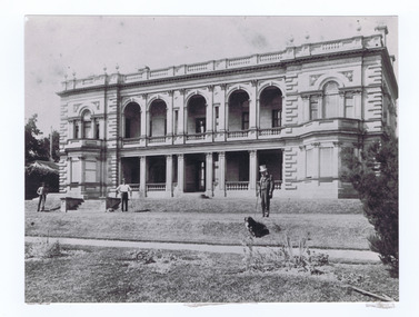
Tatura Irrigation & Wartime Camps Museum
Photograph, Dhurringile POW Camp, 2001
Dhurringile POW Camp, Garrison and POWs|Images 1 to 4- List of prisoners.|Images 5 to 6- Plan of Mansion.|Image 7- Description of Captain Van Seeden by his daughter.list -
 Bendigo Military Museum
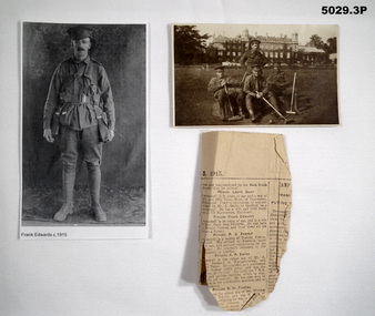
Photograph - PHOTOGRAPHS of Frank Edwards 1541, Australian Army, c1914 - 1919
Refers to service of Frank Edwards No. 1541 5th Battalion, Enlisted 30 Nov 1914. WIA 13 May 1915. Discharged Australia 23 June 1916.1. P - B & W full length portrait of Frank Edwards in uniform. He is wearing webbing, no rifle, This is a photocopy. 2, P - B & W Group portrait of four soldiers with coquet clubs in front lawn of a large mansion. This is made in the form of a postcard. 3. - Newsclipping about wounding of Frank Edwards. Melbourne Age, Sat 5 June 1915. 2. On rear, written in ink is - This is a photo of Lady Northcote's place where Frank was staying on sick 'leaf'(sic) in England. To Willie and Mary with love from Mother M.A.E.ww1, australian army