Showing 200 items matching " railway avenue"
-
 Ringwood and District Historical Society
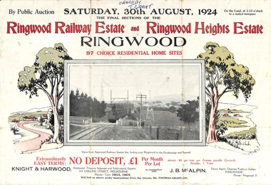
Flyer, Auction Sale Advertisement - Ringwood Railway Estate and Ringwood Heights Estate, Ringwood, Victoria - August, 1924
Refer also to Reg. No. 5183 for Ringwood Railway Estate (September 1923) and Reg. No. 5184 for Ringwood Heights Estate previous release (March 1924)Folded double-sided brochure advertising public auction of Final Sections of Ringwood Railway Estate and Ringwood Heights Estate on Saturday, 30 August, 1924, with town photographs, location map, terms of sale, and summary of local features and services.Subdivision includes Whitehorse Road, Sherbrooke Avenue, Burwood Avenue, Bon View Avenue, Grant Crescent, Hillcrest Avenue, Heatherbrae Avenue, Margaret Street, and Mary Street. (Agents) Knight & Harwood, 315 Collins Street, Melbourne, Phones Central 10615, 10616, in conjunction with J.B. McAlpin, Opposite Railway Station, Ringwood, Phone Ringwood 7. Footnote - "Will sell as above under instructions from the Owner, Mr. Thomas Grant, J.P.". -
 Ringwood and District Historical Society
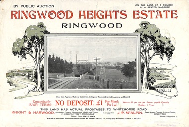
Flyer, Subdivision Advertisement - Ringwood Heights Estate Public Auction - March, 1924
Refer also to Reg. No. 5185 for Ringwood Heights Estate final section release (August 1924)Folded double-sided brochure advertising Ringwood Heights Estate Public Auction on Saturday March 1, 1924, with town photographs, location map, terms of sale, and summary of local features and services.Subdivision includes Whitehorse Road, Bon View Avenue, Grant Crescent, Hillcrest Avenue, Heatherbrae Avenue, Margaret Street, and Mary Street. (Agents) Knight & Harwood, 315 Collins Street, Melbourne, Phones Central 10615, 10616, in conjunction with J.B. McAlpin, Opposite Railway Station, Ringwood, Phone Ringwood 7. -
 Ringwood and District Historical Society
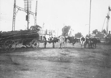
Photograph, Old railway crossing near Ringwood station, c1925
Black and white photograph (2 copies- 1 large, 1 smaller)Typed below one photograph: "Bullock team at old railway crossing near station, taken from Maroondah Highway. Circa 1925." Written on back of other photograph: "Rail crossing 1924. Team owned by Hussey. Opposite Adelaide Street and Ringwood House. Corner of Station Street and Greenwood Avenue on right." Blood Brother's store in background. -
 Darebin Parklands Association
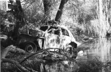
Pollution in Darebin Creek 10th February 1976, 1976
People often pushed cars and supermarket trolleys over the edge of the cliff at the end of Waverley Avenue.B&W photograph. Below Railway Bridge. This item and all other Darebin Parklands Association archival material is now held by State Library Victoria (Accession No: YMS 13746). Please contact State Library Victoria if access is required. -
 Greensborough Historical Society
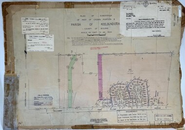
Poster - Planning Document, City of Heidelberg et al, Subdivision Plan # H 41 - Crown portion 8, Parish of Keelbundoora - Yallambie, and Crown Portion 9, Parish of Keelbundoora, 1922-1967
Planning Document: Subdivision Plan # H 41 Side 1, Crown portion 8, Parish of Keelbundoora - Yallambie Road, Allima Avenue, Koolya Court, Ekam Court (Jennings Estate). Side 2: Crown Portion 9, Parish of Keelbundoora consist of 5 small subdivision sheets: 1. Somers Avenue, Stewart Terrace, Toubay Street and Railway Place (no date); 2. Somers Avenue, Maxwell Street, Greensborough Road, 1924; 3. Heidelberg Avenue, Golf Avenue, St Andrews Avenue (no date); 4. Birdwood Avenue, May Street (no date); 5. Strathallan Road 1924.An example of hard copy subdivision plans from the Greensborough area. Mainly from the Shire of Diamond Valley era (1964-1994).Plan (2 sided) mounted on heavy card. Stamped and handwritten Council permissions, dates and other details.subdivision plans, city of heidelberg, yallambie, macleod, greensborough -
 Bacchus Marsh & District Historical Society
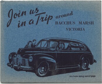
Postcard, Join us in a trip around Bacchus Marsh Victoria
This fold out series of black and white images shows scenes of Bacchus Marsh in the late 1930s or during the 1940s. The date of the set of images is not stated but it shows the Bacchus Marsh Swimming Pool constructed in 1938. The general purpose of the images to promote tourism suggests the collection may date from the post war period of the late 1940s or early 1950s when petrol rationing and other wartime restrictions were being discontinued. The eight scenes are: Railway Station Bacchus Marsh; Bacchus Marsh Post Office; Main Street Bacchus Marsh; The Avenue Bacchus Marsh; Maddingley Bridge; Swimming Pool Bacchus Marsh; Rustic Bridge Maddingley Park; View Across Maddingley Flats. The cover illustration of the fold out envelope shows a happy family in a new model car. The message of the image clearly being to encourage people to travel by motor car to places like Bacchus Marsh for recreation and to engage in the general pastime of tourism.One set of 8 fold out black and white photos showing various scenes of Bacchus, with a cover illustration of a family traveling in a motor car. Measurements: 112 x 90 mm folded; 112 x 750 mm unfoldedSouthern Series Registeredbacchus marsh history, bacchus marsh views, bacchus marsh postcards -
 Whitehorse Historical Society Inc.
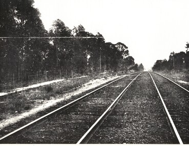
Photograph - Black and white photograph, Blackburn Railway Line
... Blackburn Railway Mitcham Glen Ebor Avenue Blackburn ...Blackburn Railway Line heading towards Mitchamblackburn railway, mitcham, glen ebor avenue -
 Melbourne Tram Museum
Photograph - Black & White Photograph/s, Tom Murray?, 1970's?
Black and white photograph of W5 727 in the reserved track section at Mathews Avenue, Niddrie, Essendon Airport line, possibly for an Australian Railway Exploration Association Tour to Tasmania. Possibly during the 1970's. Has the destination of "Tasmania via Essendon Airport" with the crew standing along side.trams, tramways, charters, special trams, tours, essendon airport, tram 727 -
 Melbourne Tram Museum
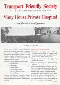
Pamphlet, Transport Friendly Society, "Transport Friendly Society - Vimy House Private Hospital", c1990
.1 - Pamphlet - two colour folded A3, titled - "Transport Friendly Society - Vimy House Private Hospital" detailing the services of the private hospital in Studley Avenue Kew, the Society, its historical origins of the Society, hospital cover, rates, insurance and financial advisor. .2 - Letter from Rebekah Blackwolf-Mitchell 24/10/2018, donating the pamphlet and the details of her father Ray Mitchell, ex Victorian Railways and the background to the donation. Hand written on a sheet of wire bound ruled notebook paper. 2 copies held.trams, tramways, vimy house, benefit society, tfs, medical -
 Melbourne Tram Museum
Postcard, Rose Stereograph Co, "Flinders Street Station and the Yarra, Melbourne", late 1920s
Rose Series postcard No. P 1666, titled "Flinders Street Station and the Yarra, Melbourne". This photo is looking southwest from St Paul's Cathedral over the station building along the Yarra river. The St Kilda/Port Melbourne and Queens bridge are in view, but not the Spencer St bridge which was built during the late 1920s. The AW Allen's Limited Confectionary Factory constructed in 1923-24 on Riverside Avenue dominates the landscape on the south side of the river directly behind the dome of the Flinders Street railways station. One very long set of horse-drawn carts can be seen alongside the center entrance to the railway station building in Flinders Street.Yields information about an aerial view of Melbourne late 1920sPostcard - printed real photograph with Rose Stereograph Co. name on the rear.tramways, trams, flinders st station, yarra river, bridges, railways, flinders st -
 City of Kingston
Photograph - Colour, Circa 1993
Edithvale is a suburb in the City of Kingston. It is located between Aspendale and Chelsea on the Port Phillip Bay and built within remnant areas of the Carrum Carrum swamp. The foreshore precinct comprises a wide sandy beach, with low sand dunes and numerous historic boat sheds. The suburb consists of older style dwellings and former holiday houses, combined with mid-century housing and newer homes. The large blocks are increasingly subdivided and the existing dwellings demolished to accommodate units and townhouses, thus changing the landscape of the area and reducing the tree canopy.The beachside suburb of Edithvale was previously part of the extensive Carrum Carrum Swamp. The area was once a source of fish and eels for the Mayone-Bulluk clan of the Bunurong people. Over time the area was drained and predominantly devoted to dairy farming and holiday houses. The farms were gradually sold and subdivided with a large number of homes built after World War II and in the 1960s. Edithvale is mainly residential with a shopping strip along Nepean Highway but little significant industry was ever established in the area apart from a plaster works and confectionary factory, both now closed.Aerial colour photograph of Edithvale as viewed from Alexandra Avenue in the north to Ella Grove Chelsea/Edithvale in the south. The area is built-up with residential housing and facilities including Edithvale Primary School, numerous churches and the Edithvale Railway station. Large sections depict the remnant Carrum Carrum swamp. Edithvale Common and the former "Duck Inn" (Melbourne Water/Friends of Edithvale Seaford Wetlands) can be seen. Edithvale Recreational reserve, the velodrome and Edithvale Public Golf Course are prominent. The image shows vacant land in the area now known as Aspendale Gardens and the newer residential section of Chelsea Heights is not developed. A bike path has been established to cover the secondary drain. The Golf Links Court residential development located off Hughes Avenue is a large vacant block.Yellow circular adhesive sticker on plastic Black ink (marker): * (asterisk) Black type on white adhesive sticker: P000108edithvale, aspendale, chelsea, carrum carrum swamp -
Canterbury History Group
Photograph - Canterbury Road, Canterbury, Jan Pigot, c 1990s
Black and white photograph of Canterbury Road Canterbury from opposite Willandra Avenue looking to the westcanterbury, canterbury road, canterbury mansions, railway bridges, power and telegraph lines, telegraph and light poles, canterbury post office -
Glen Eira Historical Society
Letter - Rosstown Railway
... Avenue Ormond Park Royal Avenue Ormond Railway Station Oakleigh ...This file contains four items: 1/A black and white photocopy of a letter dated either 07/08/1889 or 09/08/1889, from Robert Lundon to an unidentified recipient discussing an agreement reached between the author – on behalf of the recipient – and Soon Hang Hi in regard, in regards to the allotment known as Webber’s. The agreement is outlined in the letter in what appears to be Chinese characters, and includes the marks of Robert Lundon and Soon Hang Hi. File note from Joy Wu states that the calligraphy is not Mandarin or traditional Chinese. 2/Three sheets of hand-written working notes with information taken from the Victorian Government Gazette on THE ROSSTOWN AND MURRUMBEENA LAND COMPANY LIMITED, THE ROSSTOWN JUNCTION RAILWAY AND PROSPERITY COMPANY LIOMITED, and THE ROSSTOWN JUNCTION, ELSTERNWICK, AND OAKLEIGH RAILWAY COMPANY LIMITED, covering dates between 1887 and 1894. The notes concern meetings and creditors claims relevant to the companies, with reference numbers for the information source. Date and author of the notes are not recorded. 3/A black and white photocopy of the a partial map of the Rosstown Railway and surrounding area, undated. The map includes the names of landholders in the areas of Brighton, Garden Vale and Elsternwick, as well as other railway lines present in the region. 4/A fold-out map and guide of the Rosstown Rail Trail, including a brief general history of Caulfield as well as a more extensive biography of William Murray Ross and the Rosstown Railway. The map marks and describes significant sites along the trail, including photographs of some of these sites, provided by DF Jowett.documents, correspondence, webber’s, lundon robert, chinese characters, ethnic communities, signatures, text, settlements, taxes, fraser john grieves, lovell r.h., price davies, meetings, communication activities, soon hang hi, commercial events and activities, the rosstown and murrumbeena land company limited, victorian government gazette, bulmer richard, parry john, osment henry, shareholders, creditors claims, the rosstown junction railway and property company limited, finch and best, lawyers, the rosstown junction elsternwick and oakleigh railway company limited, cameron w.c., phillips p.d., garden vale, elsternwick, elsternwick railway station, rosstown, rosstown railway, thomas street, bay street, kooyong road, melbourne and brighton railway, hawthorn road, bambra road, caulfield and frankston railway, booran road, grange road, koornang road, murrumbeena road, north road, north road railway station, east brighton railway station, south road, railway routes, railway lines, railways, land transport, murphy j., caulfield, hamilton t.f., dane p., holloway, webb, ailee john, payne t.b., brodie chas, dane john, o’neil h., mccombie john, mcmillane a., smyth c.d., cooper, ebden, landholders, jeffrey j.d., gill j., balcombe a.e., cooper h., mcnab j., white j., sutherland j., greeves a.f.a., newton m.c., chamley f.b., fowler j., inglis p., grant t., stooke j., swanson g., cochrane c., adams e.b., mccombie thas, keyes robert, brighton cemetery, burials grounds and graveyards, war-ein road, were j.b., holland j., mcmahon c., winter t.l.m., dendy henry, mitchell w., jackson s., were j.e., wickham francis dawe, bryant jane, east brighton railway station, railway stations, maps, allotments, land titles, roads and streets, rosstown rail trail, city of glen eira, tourism, trains, tourism information bureaus, tours, pamphlets, elsternwick railway park, oakleigh junction, princes park, ee gunn reserve, packer park, sites, jowett d.f., weickhardt i.g., return to rosstown: railways land sales and sugar beet ventures in caulfield, land sales, walking trails, ross william murray, transport objects, locomotion, walking, cycling, driving, sports, country mansions, people, caulfield john, builders, construction and demolition workers, occupations, careers, professionals, topography, geology, landforms, horticulture, market gardens, primary industry workers, city of caulfield, mood kee, pennington harold, annual general meetings, caulfield town hall, glen eira city council, carnegie, carnegie station, rosstown station, people by circumstance, migrants, sugar beet, sugar beet mill, sugar beet industry, mills, factories, sea beach lines, bent thomas, parliamentary representatives, neville street, miller street, lemann’s swamp reserve, koornang park, cane sugar industry, breweries, rabbit processing plants, health establishments, hospitals, food production establishments, abattoirs, thieves, social problems, vagrants, theft, squatting, financial economics, debt, finance industry, insurance companies, company managers, bentleigh, ross leila, the grange, leila road, wild cherry road, financial trouble, mortgages, gisborne street, archibald street, riddell parade, victoria railways, glen huntly road, clarence street, college street, gladstone parade, parrell street, aileen avenue, seaview street, land subdivisions, dover street, sussex street, landfill, marara road, booran road, woodville avenue, dorothy avenue, ormond park, royal avenue, ormond railway station, oakleigh road, melten avenue, miller street, munro avenue, lord reserve, neerim road, toolambool road, the rosstown hotel, rosanna street, murrumbeena crescent, commercial establishments, the national bank, rosstown road, kangaroo road, poath road, freda street, hughesdale kindergarten, oakleigh council, hughesdale community centre, civic establishments, galbally reserve, plaques, warrigal road, out and about brochures, orion estate -
Canterbury History Group
Article, Newsmaker, 15/08/2012 12:00:00 AM
An interview from the Boroondara Local Review, 15 August 2012 with Jack Roach.Includes a coloured photographAn interview from the Boroondara Local Review, 15 August 2012 with Jack Roach. canterbury, alexandra avenue, roach> jack, boroondara residents' action group, town planning, camberwell railway station, railway stations, rush> geoffrey, humphries> barry -
 Ringwood and District Historical Society
Map, Plan of Subdivision - State School Estate, Ringwood East, Victoria - (Undated, circa 1920s)
Map of land for sale attached to green cardboard backing with handwritten notations showing numbered allotments on Dublin Road, Holland Road, King Street, Charles Street and Purser Avenue, Ringwood East.Locality plan includes reference to proposed Ringwood East railway station which opened in 1925. -
 Chelsea & District Historical Society Inc
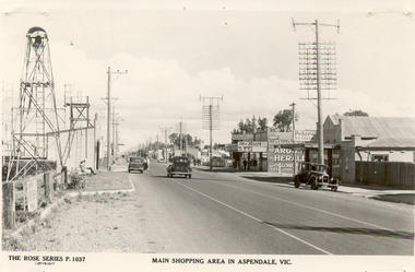
Photograph - Shopping Area, Aspendale, c 1930's
Black and white postcard showing shops on the right hand side of Point Nepean Road and the railway line, Aspendale railway station and the Aspendale Fire Station with the bell tower beside it. One car driving along the road and two cars parked. The shops in view are a cafe, a general store, the Aspendale Picnic Grounds, which included Palais De Dance.The Rose Series P. 1037 MAIN SHOPPING AREA IN ASPENDALE, VIC.point nepean road, nepean highway, aspendale, taylor avenue, shops, aspendale fire station, aspendale picnic grounds -
 Ringwood and District Historical Society
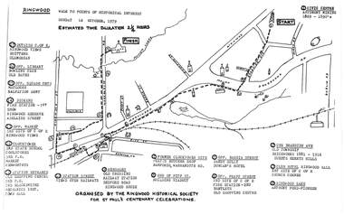
Pamphlet, Ringwood Walk - Points of Historical Interest, 1979
Sketch of walking route for 17 historical points of interest organised by the Ringwood Historical Society for St. Paul's Church Centenary Celebrations - 14 October 1979, estimated duration 2-1/4hours.1 - Start 2 - Cnr Braeside Avenue, old township, brickworks 1881-1916, Guests, Herrys, Hills 3 - Club Hotel, Ringwood Hall, 1st site of C of E church corner 4 - Ringwood Lake, Anthony Ford - pioneer 5 - Opposite Bardia Street, Sandy Gully, Duncan's Hotel 6 - Opposite Pratt Street, 2nd site of C of E, 2nd fire station, Bentleys, old shopping centre 7 - Warrandyte Road, Former Clocktower site, Pratts butcher shop, Bamfords 8 - End of Pitt Street, building viaduct 9 - Bedford Road, Webdales, old crossing, railway station 10 - Station Street, views over railways 11 - Station entrance, old shopping centre, 2nd Postoffice, 2nd blacksmiths, Mechanics Institute, Town Hall 12 - Clocktower, 3rd State School, coolstores, 3rd Postoffice, market, Kenworthys 13 - Opposite market, 3rd site of C of E, Ringwood views 14 - Adelaide Street, Dickens, 1st fire station, Ringwood Reserve 15 - Opposite squash courts, Matlocks, Salvation Army 16 - Opposite library, bowling club, old baths 17 - Outside C of E, Ringwood views, Brittens, Glamorgan -
 Narre Warren and District Family History Group
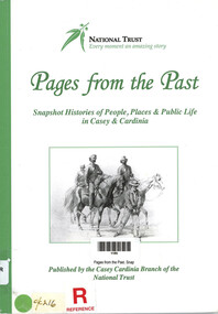
Book, National Trust of Australia (Victoria). Casey-Cardinia Branch, Pages from the Past. Snapshot Histories of People, Places & Public Life in Casey & Cardinia, 2011
Contents include: Richard Gavin Gardiner Casey [Edrington]; The Police Paddocks and the Native Police Corps; The changing face of Berwick township; Coaches, tolls and local councils; Berwick Mechanics Institute and Free Library; Berwick Primary School [No. 40] and Berwick Grammar School; A century of quarrying in Berwick; The German settlement of Harkaway; Emerald’s first State School No. 2110 (1879-1909); The railway to Gippsland; Early sawmilling in West Gippsland; Tooradin and the coastal villages; Some notable early residents and their homes; The draining of the Koo-Wee-Rup swamp; Guest houses at Upper Beaconsfield; Ada Armytage of Holm Park; The soldiers of early Berwick; Memorials, commemorations and avenues of honour; Bush nursing hospitals; The Melbourne Hunt Club [The "Kennels" at Cranbourne]; Growing up in Berwick in the 1930s & 1940s; Growing up in Beaconsfield in the 1930s and 1940s; Casey Airfield; The history of Maryknoll [Catholic farming community]; The filming of “On the beach”; Memories of Ash Wednesday; Maps of the Casey-Cardinia area. Notable people : William Lyall and "Harewood'; William Clarke and "Springfield'; Sydney Webb and "Holly Green"; Carl Axel Nobelius; Edwin Flack and "Burnbank"; Carlo Catani;. Includes illustrations, portraits, photographs, maps and bibliography.106 p. : ill., portraits, map, bib., pbk ; 30 cmnon-fictionContents include: Richard Gavin Gardiner Casey [Edrington]; The Police Paddocks and the Native Police Corps; The changing face of Berwick township; Coaches, tolls and local councils; Berwick Mechanics Institute and Free Library; Berwick Primary School [No. 40] and Berwick Grammar School; A century of quarrying in Berwick; The German settlement of Harkaway; Emerald’s first State School No. 2110 (1879-1909); The railway to Gippsland; Early sawmilling in West Gippsland; Tooradin and the coastal villages; Some notable early residents and their homes; The draining of the Koo-Wee-Rup swamp; Guest houses at Upper Beaconsfield; Ada Armytage of Holm Park; The soldiers of early Berwick; Memorials, commemorations and avenues of honour; Bush nursing hospitals; The Melbourne Hunt Club [The "Kennels" at Cranbourne]; Growing up in Berwick in the 1930s & 1940s; Growing up in Beaconsfield in the 1930s and 1940s; Casey Airfield; The history of Maryknoll [Catholic farming community]; The filming of “On the beach”; Memories of Ash Wednesday; Maps of the Casey-Cardinia area. Notable people : William Lyall and "Harewood'; William Clarke and "Springfield'; Sydney Webb and "Holly Green"; Carl Axel Nobelius; Edwin Flack and "Burnbank"; Carlo Catani;. Includes illustrations, portraits, photographs, maps and bibliography. city of casey, cardinia shire (vic.) -
 Chelsea & District Historical Society Inc
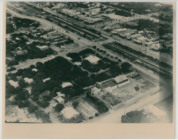
Photograph - Aerial Photo of Chelsea, c 1923
Points of interest in the photo are Fox Theatre, Chelsea Railway Station and the building site of Masons Theatre on the corner of Chelsea Road and Station Street. Mr William Herbert Hansom was a pioneer of aerial photography in Australia.Black and white aerial photo of Chelsea, bordered by Thames Promenade, Balantyne Avenue, Catherine Avenue and Chelsea Road, Station Street, The Strand, Bath Street.W. H. Hansom ("Manders") Aerial Artist, Personally Conducted Flights over Melbourne and Suburbs St James' Building Bourke Street, Melbournechelsea, aerial photo, station street, chelsea road, the strand, bath street, fox theatre, masons theatre, w. h. hansom, chelsea railway station -
 Federation University Historical Collection
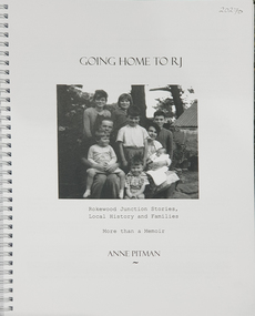
Book, Anne Pitman, Going Home to RJ: Rokewood Junction Stories, Local History and Families: More than a Memoir, 2023
Beverley Chatham ( daughter of Arthur Chatham) suggested that Commerlghip refers to Watering holes and underground springs found in the Little Woady Yallok and Mt Misery Creeks. Rokewood Junction was proclaimed a township in 1885, originally known as a gold-mining township called Paddy's Gully Diggings.Ringbound publication of 212 pagesnon-fictionBeverley Chatham ( daughter of Arthur Chatham) suggested that Commerlghip refers to Watering holes and underground springs found in the Little Woady Yallok and Mt Misery Creeks. Rokewood Junction was proclaimed a township in 1885, originally known as a gold-mining township called Paddy's Gully Diggings. rokewood, rokewood junction, chatham, kurus-a-ruc, henry pitman, elizabeth pitman, william henry pitman, rokewood junction state school, commeralghip, paddy's gully bridge, illabrook, conereyalk, woady yalloak creek, mt misery creek, paddy's gully diggings., dereel, pitfield, wadawurrung, william rutland, squatters, aborigines, aboriginal, charlotte walsh, maurice walsh, julie pitman, ben liston, sheep and wool, george hawkins, natthew wakeling, christopher moody, mt misery goldfield, john bower, mary bower, hyslop's hotel, cumberland store, jane hyslop, edward collyer, jospeh gladstone, lucas's bakery, henry batty, william young, ellen rigby, chinese, joseph anguey, eliza anguey, murder of thomas ulick burke, william achultze, william schiltze, nicholas grenfell, tomas bramley murder, emily malhoff, drowning, ah lin, eliza richards, luisa bupell, eleanor holmes, rachel holmes, joseph holloway, noah holloway, thomas faulkner, robert eli hearn, george todhunter briggs, john robinson fairweather, rokewood common, edward bussell, louisa bussell, irving rachinger, john chatham, doris chatham, peter chatham, jack chatham, imogen chatham, domenico rizzoli, mary rizzoli, rokewood junction railway line, illabrook football and netball club, cape clear, red cross, keith annear, fire brigade, rokewood junction post office, len aarons, dereel pre-emptive right, rokewood junction avenue of honour, arthur chatham