Showing 2823 items
matching residence
-
 University of Melbourne, Burnley Campus Archives
Pamphlet, What's Happening Now Until march 2006, 2006
administration, students -
University of Melbourne, Burnley Campus Archives
Programme, Institute of Land and Food Resources, The University of Melbourne, Nursery Industry Seminar Day, 2000
seminar, nursery industry -
University of Melbourne, Burnley Campus Archives
Booklet, School of Land and Environment, Melbourne School of Land and Environment Postgraduate Conference 2008, 2008
postgraduates, conference -
University of Melbourne, Burnley Campus Archives
Document - Curriculum, Institute of Land and Food Resources, The University of Melbourne, Subject Listing - New Curriculum, c.2000
curriculum, subjects -
University of Melbourne, Burnley Campus Archives
Document - Curricula, Institute of Land and Food Resources, The University of Melbourne, Undergraduate Transition Plan 2001, 2000
undergraduates, curricula -
University of Melbourne, Burnley Campus Archives
Booklet - Course Information, Advanced Certificate in Horticulture, 1999
courses, t.a.f.e. -
University of Melbourne, Burnley Campus Archives
Document - Prospectus, School of Land and Environment, Graduate Prospectus, 2011
courses, graduates -
University of Melbourne, Burnley Campus Archives
Administrative record - Report, Woodards Commercial, Property Report, 2008
finance, valuations, buildings -
University of Melbourne, Burnley Campus Archives
Administrative record - Report, The University of Melbourne, Faculty of Land and Food Resources, The Burnley Master Plan, 2007
finance, buildings -
University of Melbourne, Burnley Campus Archives
Administrative record, School of Land and Environment, Conferring of Degrees, 2009
graduation, burnley campus, creswick campus -
University of Melbourne, Burnley Campus Archives
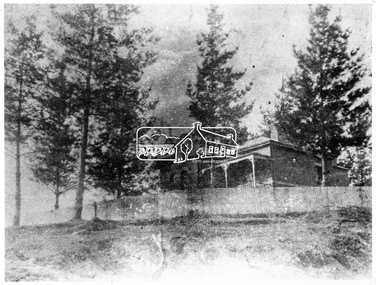
Photograph - Black and white print, 395/32
Close up of Egg-laying Curator's residence.egg laying, curator, residence, e. m. gibson collection -
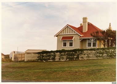 Flagstaff Hill Maritime Museum and Village
Photograph - Historical, Flagstaff Hill, Harbourmaster’s Quarters, 1970s
The photograph shows a cottage, Harbourmaster’s quarters that still stands on the east of the Lady Bay Lighthouse and Historic Precinct at Flagstaff Hill in Warrnambool. The name was changed to the Lighthouse Lodge, and today guests can stay at the property. This photograph, a print, is one of a set of five that show the site of Flagstaff Hill. It is presumed to have been taken by John Lindsay, Founding Director of Flagstaff Hill Maritime Museum and Village. One of the photographs in the set has the pencil inscription "Photo J Lindsay". It was taken in the early 1970s during the initial stages of the development of Flagstaff Hill as a Museum and Maritime Village. The photographs belonged to the donor's grandparents, who lived in the Warrnambool district of Allansford/Naringal. The photograph is a record of the site and surrounds of Flagstaff Hill Maritime Museum and Village before its development and opening in 1975. It shows the cottage on the east of the Lighthouse Complex,. The building is now known as Lighthouse Lodge. The photograph is significant for recording the location and condition of the residence on the Hill.Coloured photograph, glassy print, one of a set of five. Photograph shows the cream timber cottage, Harbourmaster’s quarters to the east of the lighthouse complex at Flagstaff Hill, Warrnambool. On the left of the red roofed residence are iron buildings used, at the time, by the Lands Department. The photograph's paper has the printer's watermark on the back. The early 1970s photograph is presumed to have been by John Lindsay, Warrnambool.Label on the back: "WOODEN RESIDENCE TO THE EAST OF THE PROPERTY / The gun emplacements are immediately behind, and the iron huts to the left rear of the residence are used by the Lands Department who plan to vacate, for other premises."flagstaff hill, flagstaff hill maritime museum and village, warrnambool, maritime museum, maritime village, great ocean road, shipwreck coast, 1970s, photograph, flagstaff hill site, john lindsay, cannon emplacement, residence, wooden residence, timber residence, iron huts, lands department -
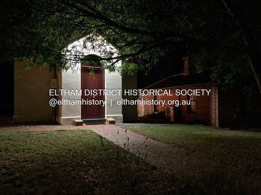
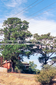 Eltham District Historical Society Inc
Photograph (Item) - Negative, Craig Price, Former Headmaster's Residence, Eltham Primary School, Dalton Street, Eltham, 1988
Craig Price 1988 Entrant No. 148 Ref: Series 34, Items 37, 38, 109, 110 The images in this record were not selected for inclusion. SHIRE OF ELTHAM COMMUNITY PHOTOGRAPHIC SURVEY Photography is an artform which many of us practice, sometimes purely for artistic pursuit, sometimes to record the people and events in our lives. In 1988, as part of a local Bicentennial project, the Shire of Eltham conducted the Eltham Community Photographic Survey. Up to 100 entries were to be selected by a panel of photographers for entry into the Eltham Photographic Survey Exhibition. Entries had to be submitted by May 13, 1988. Entrants whose images were selected for the exhibition were contacted and requested to further submit an entry form providing entrant’s name, area of residence, age, and proposed captions. These details were then used to produce labels for the exhibition mounts. Where negatives had not been supplied, these were requested to support the display of printed enlargements mounted on 10” x 8” cardboard. The mounted prints were made available post exhibition for sale at $8.50 each for colour prints and $7.00 for B&W prints. Residents in the Shire were invited to collect a free roll of film and take a photograph of what they either liked or did not like about the area. A total of 160 entrants submitted multiple entries for the exhibition. Of those selected for exhibition, entrants ranged in age from 9 to 70 years. All custom colour and black and white printing for the exhibition was completed by Wattle Studios of Eltham. The Eltham Photographic Survey was jointly auspiced by the Shire of Eltham and Wattle Studios, of 953 Main Road, Eltham. The project was greatly assisted by: • David McRitchie, Media Studies Lecturer Victoria College, Rusden Campus. • Ian and Annette Toohill of Wattle Studios • Tracy Naughton, Eltham Community Arts Officer • Neville Emerson Pty. Ltd. • Superior Press, Eltham • Kodak Australasia Pty. Ltd. • Agfa Gevaert Ltd. • Townsend Colourtech Pty. Ltd. • The Australian Bicentennial Authority • Eleanor Bowers, Secretary, Eltham Arts Council The exhibition was placed on display in the Woolworths Arcade, Eltham between Monday June 6th and Saturday June 11, 1988. It was also intended to hold the exhibition at a venue in the Shire’s North Riding from Monday, June 20 to Friday June 24. It was then displayed at the Were Street Theatre, Montmorency from Friday, June 24 to Thursday, July 7. Series 34: Eltham Community Photographic Survey 1988 - Prints & Documentation Series consists of 117 photographs of Shire scenes taken by members of the community. Items I - 41 are larger photographs mounted on card, which were exhibited. Items 42 - 117 are unmounted copies, alternative takes and other entries. Corresponding negatives contained in Series 35: Eltham Community Photographic Survey 1988 – Negatives which consists of 267 colour and B&W negatives and one colour slide of Shire scenes taken by members of the community. The negatives are arranged by the entrant number of the photographer. The Eltham Community Photographic Survey collection is significant to the local community as it was curated by the local community - ordinary people of all ages - representing what they liked and did not like in the area where they lived. It represents an unfiltered representation of the Shire of Eltham as it was in 1988. It also represents one of many projects as part of the national programme of events and celebrations to commemorate the bicentenary. It is a time capsule of life in the 1980s of this urban and rural municipality in Melbourne's north. shire of eltham archives, bicentennial project, eltham community photographic survey, craig price, film - kodak ga 100 5095, scan - 35mm negative, series 35, dalton street, eltham primary school, headmaster's residence, state school no. 209 -
 Eltham District Historical Society Inc
Photograph, Woodburn residence, mudbrick adobe (1949), Eltham Heritage Tour, 24 May 1992, 24/05/1992
ELTHAM HERITAGE TOUR The Society excursion on 24th May 1992 was arranged by David Bick, leader of the team carrying out the Shire's heritage study. David selected a number of sites or buildings identified in the study, some of them lesser known components of the Shire's heritage. The tour commenced at the Eltham Shire Office at 10.00 am. Travel was by private car and mini-bus with stops at about twelve locations for commentary by David.It included a short walk in Hurstbridge and lunch at Kinglake. Highlights of the tour included: - 10 am Leave from Shire Offices - 3 Important Trees - A Physical Link to Eltham's First Settlers - Toorak Mansion Gates - A Surviving Farm House - An Intact Circa 1900 Main Street - First Settlers - Gold Miners, and Timber-getters - An Early Hotel - A Pioneering Homestead - Changing Eltham Shire - 20th Century - 4 pm Afternoon Tea and Finish Tour Extract from ELTHAM CULTURAL HERITAGE TOUR (Newsletter No. 85, July 1992, by Bettina Woodburn) "In some respects Eltham is a 'back-water' and it has its own distinctive flavour. On the outskirts the homes date from the 1960's, 70's and 80s with a sprinkling of 'earth homes', mud-brick or pise, rammed dirt. Crossing Main Road into Beddoe Street and Thompson Crescent a very pleasant drive past pines and old fence lines, front lawns unfenced, the occasional ·old farm building, we eventually looked down on a huge circular roof of a 1992 adobe home. Other distinctive places included the Pauline Toner Butterfly Reserve, Gordon Ford's splendid garden at Fulling in Pitt Street, cypress hedges and old houses in Bridge Street and in every direction Eltham's special feature - a totally treed horizon. We were now in the part of the Shire closest to Melbourne - Montmorency - not on the way to anywhere, with no through road going across it, developed in the 1950's and 1960's with conventional gardens, now converted to native plants. The rail looped between Greensborough and Eltham and a shopping street (Were Street) served the area, growing up the hill from the station. It was a typical outer Melbourne suburb with lawns and roses with patches of originality. The shopping precinct still has 1950 characteristics - walls which sloped back, projecting roofs, the original shop fronts are nearly all tiled below the old windows. There's an air of past times about the School, the Dairy, the Butcher's (now a milk bar) and the Castlemaine stone face of the Commonwealth Bank. The final stop for the tour was at the mud-brick Woodburn residence, adobe of 1949 with additions. After War Service, Bill Woodburn had commenced an Architecture course at Melbourne University and after second year in the Christmas vacation, with his wife, Betti, built the two bedroom house - with amazing saving of costs. In the three and a half months they made over 3000 bricks (external walls 18" x 12" x 4", internal walls 12" x 9" x 4"), sifted top soil for mortar and laid them, on concrete foundations and slab floor, made all the structural window frames, door frames and roof members to carry 'super six' asbestos sheets, laboured for the electrician and plumber, did all the glazing and, still without electricity, moved in in March 1949. Rooms have been added, at first with glass walls, later using concrete blocks, to accommodate three daughters and a son. The house not only grew from the earth, but also with the family."Record of the Society's history and activities and highlighting various aspects of the Heritage Study undertaken by David Bick used to create the future heritage overlay for the Shire of Eltham and later Nillumbik Shire.Roll of 35mm colour negative film, 4 stripsKodak Gold 100 5095shire of eltham historical society, activities, heritage tour, woodburn house -
 Ringwood and District Historical Society
Photograph, 9 Wantirna Road, Ringwood, that was once the residence of the Secretary of The Ringwood Building Society, Circa 1991
Digital photograph -
 Eltham District Historical Society Inc
Photograph - Digital Photograph, Jim Connor, Former Police Residence, 728 Main Road, Eltham, 4 May 2020
Part of the Eltham Justice Precinct, now the Local History Centre, home of Eltham District Historical Societyjim connor collection, justice precinct eltham, local history centre, police residence -
 Eltham District Historical Society Inc
Photograph - Digital Photograph, Jim Connor, Former Police Residence, 728 Main Road, Eltham, 22 October 2020
Part of the Eltham Justice Precinct, now the Local History Centre, home of Eltham District Historical Societyjim connor collection, justice precinct eltham, local history centre, police residence -
 Eltham District Historical Society Inc
Photograph - Digital Photograph, Jim Connor, Former Police Residence, 728 Main Road, Eltham, 26 October 2021
Part of the Eltham Justice Precinct, now the Local History Centre, home of Eltham District Historical Societyjim connor collection, justice precinct eltham, local history centre, police residence -
 Eltham District Historical Society Inc
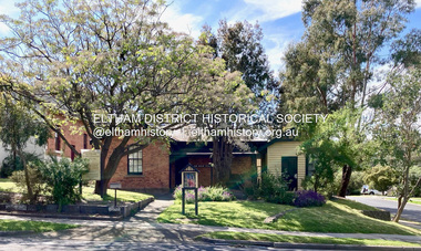
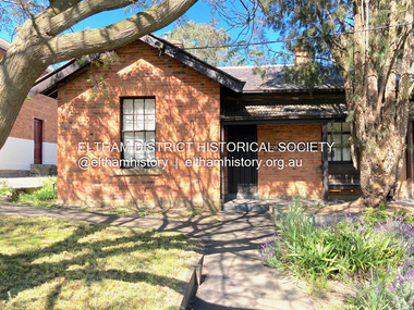
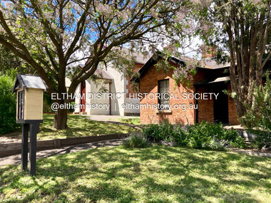
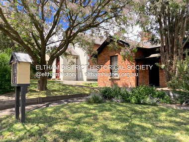
Photograph - Digital Photograph, Jim Connor, Former Eltham Courthouse and Police Residence, 728-730 Main Road, Eltham, 14 November 2021
Part of the Eltham Justice Precinct, now the Local History Centre, home of Eltham District Historical Societyjim connor collection, justice precinct eltham, eltham court house, local history centre, police residence -
 Eltham District Historical Society Inc
Photograph - Digital Photograph, Jim Connor, Former Eltham Courthouse and Police Residence, 728-730 Main Road, Eltham, 18 December 2021
Part of the Eltham Justice Precinct, now the Local History Centre, home of Eltham District Historical Societyjim connor collection, justice precinct eltham, eltham court house, local history centre, police residence -
 Eltham District Historical Society Inc
Photograph - Digital Photograph, Jim Connor, Former Eltham Courthouse and Police Residence, 728-730 Main Road, Eltham, 23 March 2023
Part of the Eltham Justice Precinct, now the Local History Centre, home of Eltham District Historical Societyjim connor collection, justice precinct eltham, eltham court house, local history centre, police residence -
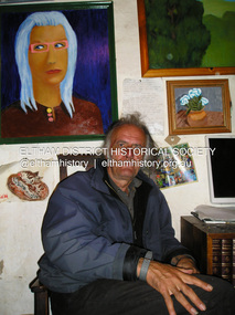 Eltham District Historical Society Inc
Photograph, Fay Bridge, Damien Skipper at his place residence at Montsalvat, 9 April 2018
2018-04-09, Damian Skipper, Fay Bridge Collection, Montsalvatfay bridge collection -
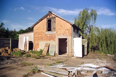 Eltham District Historical Society Inc
Photograph, Doug Orford, The old Police Stables at rear of former Police Residence and Police Station, 728 Main Road, Eltham, 1985, 1985
Roll of 35mm colour negative film, 7 stripsFuji 100Neltham, local history centre, main road, police stables, police station, police residence -
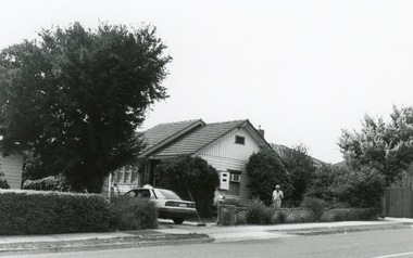
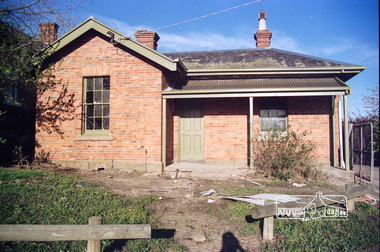 Eltham District Historical Society Inc
Photograph, Doug Orford, Former Police Residence, 728 Main Road, Eltham, 1985, 1985
Roll of 35mm colour negative film, 7 stripsFuji 100Neltham, local history centre, main road, police residence -
 Eltham District Historical Society Inc
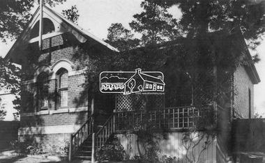
Photograph, Headmaster's Residence, Eltham State School No. 209, Dalton Street, Eltham, c.1920
Pre town water of 1926. Water tank is cube shaped used as containers of powders etc from overseas.dalton street, eltham, eltham state school no. 209, headmaster's resience -
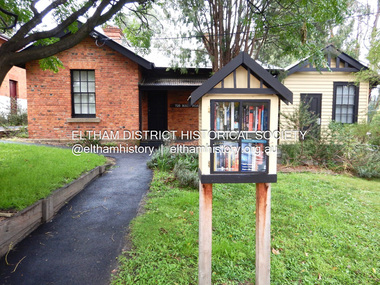
 Eltham District Historical Society Inc
Photograph, Diamond Valley Leader, Eltham Local History Centre, former Police Residence, 728 Main Road, Eltham, 1998
Members of the Eltham District Historical Society transfer collection items from storage into their new home. Previously occupied by the Parks and Environment Department of Nillumbik Shire Council (L-R: Mark Gillham, Margaret Ball Vice President, Sue Law Immediate Past President, Harry Gilham President) Nillumbik Shire Council Commissioner Vin Heffernan (1996-97) worked with Harry Gilham to obtain use of the former Eltham Shire Parks and Gardens office at 728 Main Road for use by the Society. Harry as a younger man had played in the scrum for Heidelberg Football Club along with Vin's brother who was on the wing. Apparently Heffernan was able to access $30K to spend on the site to fix it up for occupation.Colour photo print 12.5 x 19 cmLeaser Newspaper Groupmargaret ball, mark gilham, police residence, sue law, 728 main road, activities, eltham, eltham district historical society, harry gilham, justice precinct, local history centre -
 Eltham District Historical Society Inc
Slide - Photograph, Former Police Residence, Main Road, Eltham, c.1997
Immediately prior to becoming the home of the Eltham District Historical Society and Local History Centre35mm colour positive transparency Mount - Black and Whiteeltham, eltham district historical society, local history centre, main road, police residence, police station -
 Eltham District Historical Society Inc
Photograph, Eltham Local History Centre, former Police Residence, 728 Main Road, Eltham, 1998
Members of the Eltham District Historical Society transfer collection items from storage into their new home. Previously occupied by the Parks and Environment Department of Nillumbik Shire Council (L-R: Mark Gillham, Margaret Ball Vice President, Sue Law Immediate Past President, Harry Gilham President) Nillumbik Shire Council Commissioner Vin Heffernan (1996-97) worked with Harry Gilham to obtain use of the former Eltham Shire Parks and Gardens office at 728 Main Road for use by the Society. Harry as a younger man had played in the scrum for Heidelberg Football Club along with Vin's brother who was on the wing. Apparently Heffernan was able to access $30K to spend on the site to fix it up for occupation.Colour photographeltham district historical society, harry gilham, margaret ball, mark gilham, sue law, local history centre, 728 main road, activities, eltham, justice precinct, police residence -
 Eltham District Historical Society Inc
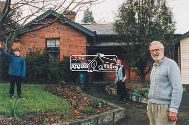
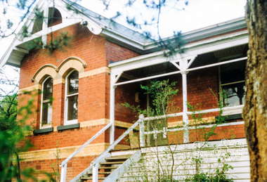
Photograph, Eltham - State School Residence, Dalton Street
View of the headmaster's house at Eltham State School, Dalton Street. The building still stands.This photo forms part of a collection of photographs gathered by the Shire of Eltham for their centenary project book,"Pioneers and Painters: 100 years of the Shire of Eltham" by Alan Marshall (1971). The collection of over 500 images is held in partnership between Eltham District Historical Society and Yarra Plenty Regional Library (Eltham Library) and is now formally known as the 'The Shire of Eltham Pioneers Photograph Collection.' It is significant in being the first community sourced collection representing the places and people of the Shire's first one hundred years.Digital imagesepp, shire of eltham pioneers photograph collection, state school residence, eltham state school, state school no. 209, dalton street, eltham primary school -
 Eltham District Historical Society Inc
Photograph, Harry Gilham, The former Headmaster's residence, Eltham State School No. 209
Colour photographeltham primary school, headmaster, state school no. 209, houses