Showing 1625 items
matching yarra river
-
 Ballarat Heritage Services
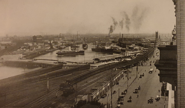
Image, Melbourne Port on the Yarra River, c1918, c1918
... Melbourne Port on the Yarra River, c1918...yarra river... Office goldfields port of melbourne yarra river melbourne ...Black and white image of the Port of Melbourne.port of melbourne, yarra river, melbourne, immigration, boats, ships -
 Kew Historical Society Inc
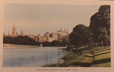
Postcard, Nucolorview Productions, Melbourne Skyline and Yarra River
... Melbourne Skyline and Yarra River...yarra river... -- melbourne yarra river christian-washfold collection Coloured matte ...One of a number of 'real photo' and commercial postcards created by or owned by members of the Christian and Washfold families of Kew. The postcards are part of a larger collection of photographs, postcards and publications donated to the collection in May 2021.Coloured matte postcard with skyline including State Theatre (Forum) in distance.postcards -- melbourne, yarra river, christian-washfold collection -
 Eltham District Historical Society Inc
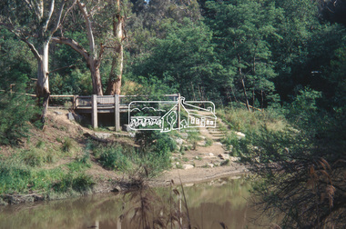
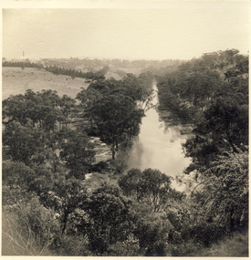
Slide - Photograph, Viewing platform near the confluence of Diamond Creek and Yarra River, c.Nov. 2001
... Yarra River...yarra river... Creek and Yarra River Slide Photograph ...In October 1996 the viewing platform was opened. It is situated near Lenister Farm on the Diamond Creek trail. It was a joint project involving Nillumbik Shire Council, Skill Seekers Inc., Department of Natural resources and Environment and Department of Employment, Education, Training and Youth Affairs. The platform was officially opened by Don Cordell Chairman of Commissioners. Part of a slide show presentation "A Trip Down the Diamond Creek" by Russell Yeoman to the Eltham District Historical Society meeting of 14 Nov. 200135mm colour positive transparency Mount - Black and Whiteconfluence, diamond creek, yarra river, viewing platform -
 Lakes Entrance Historical Society
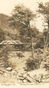
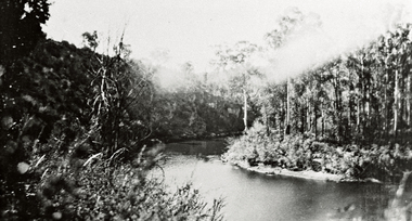
Photograph - Post card Rose series 3643 Warburton, Rose Stereographers Armadale Victoria, Yarra River, Warburton Victoria, 1920 - 30 c
... Yarra River, Warburton Victoria...Sepia toned postcard showing white wooden bridge over Yarra... white wooden bridge over Yarra River with hill at back densely ...The writer of the message on back of card was a Miss Ruth Catt who boarded with the family of Vic and Myrtle Fish of Roadknight St Lakes Entrance in the 1920 - 30 She was a teacher at the Bunga Creek State School East of Lakes Entrance and walked through the bush to schoolSepia toned postcard showing white wooden bridge over Yarra River with hill at back densely wooded shrubbery along river bank and rocky foreground at Warburton VictoriaThe Rose Series P3643 The Beautiful Yarra Warburton Victoriaschool teachers -
 Wonga Park Community Cottage History Group
Photograph (Item) - Black and White, Wonga Park: A view of the Yarra River
... Wonga Park: A view of the Yarra River...Wonga Park: A view of the Yarra River... of the Yarra River Photo is named 14880031.jpg on CD Wonga Park: A view ...Wonga Park: A view of the Yarra RiverPhoto is named 14880031.jpg on CD -
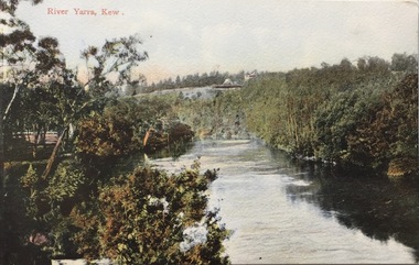
 Kew Historical Society Inc
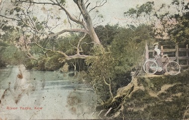
Postcard, River Yarra, Kew, 1905-1914
... River Yarra, Kew...postcards -- Yarra River -- Kew (Vic.)...Polychrome postcard of the River Yarra at Kew, showing... to the River Yarra in Kew. postcards -- kew (vic.) postcards -- Yarra ...The Kew Historical Society's postcard collection includes views of Kew, Melbourne and Greater Melbourne as well as those including overseas scenes sent or received from Europe or the Middle East. They date from the 1890s to the 2000s. These postcards may or may not include the name of the publisher or printer. A number of the cards were published as parts of popular series. A way of dating early postcards is to identify whether the reverse was divided by a central line which became the norm after 1902 in the United Kingdom. However, other postcards produced after this date do not always conform to this print layout.One of a series of pictorial postcards showing a woman on a bicycle near to the River Yarra in Kew.Polychrome postcard of the River Yarra at Kew, showing a woman with a bike (right) looking away from the River.My dear friend I suppose you will think I am a "beauty", but I have no excuse to offer for not writing, only the longer I put it off the longer I want to. I hope the change did you a lot of good & that you feel quite well & strong. Everything here is something about the same. Our two new ministers are nice but I like Mr Dowsing better so far. The weather lately is glorious, just the thing for long walks. Jane Rowe & I go for a walk after church on Sunday nights. That is the most walking I do lately. No room for more. Love from your friend C.G.[sic]postcards -- kew (vic.), postcards -- yarra river -- kew (vic.), colour postcards -- kew (vic.) -
 Wonga Park Community Cottage History Group
Photograph (Item) - Black and White, Wonga Park: Yarra River with Crooning Waters house and Mt Lofty
... Wonga Park: Yarra River with Crooning Waters house and Mt...Wonga Park: A view of the Yarra River with Crooning Waters... of the Yarra River with Crooning Waters house and Mt Lofty Photo ...Wonga Park: A view of the Yarra River with Crooning Waters house and Mt LoftyPhoto is named 14880031.jpg on CD -
 Eltham District Historical Society Inc
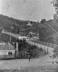
Photograph, Warrandyte Bridge on River Yarra
... Warrandyte Bridge on River Yarra ...Yarra River...Bridge across the Yarra River which links North Warrandyte... melbourne Bridge across the Yarra River which links North Warrandyte ...Bridge across the Yarra River which links North Warrandyte and Warrandyte. A house sits prominantly on a hill in the distance. A wooden building on the side of the road before the bridge has advertising for Wardrop Tailor, Smith Street, Collingwood. It is suggested that the photo has had this fake information added at a later date. Wardrop Tailor did operate from about 1915 to 1921. Alternataive title: Warrandyte Bridge - River Yarra. "Wardrop-Tailor, Smith St. C'wood" sign - faked?This photo forms part of a collection of photographs gathered by the Shire of Eltham for their centenary project book,"Pioneers and Painters: 100 years of the Shire of Eltham" by Alan Marshall (1971). The collection of over 500 images is held in partnership between Eltham District Historical Society and Yarra Plenty Regional Library (Eltham Library) and is now formally known as 'The Shire of Eltham Pioneers Photograph Collection.' It is significant in being the first community sourced collection representing the places and people of the Shire's first one hundred years.Digital imagesepp, shire of eltham pioneers photograph collection, warrandyte, bridge, north warrandyte, yarra river, wardrop tailor, collingwood -
 Heidelberg Golf Club
Book, Melbourne Parks and Waterways, Lower Plenty River concept plan: Maroondah Pipe Track to Yarra River, 1994
... Yarra River... to Yarra River. Includes suggestion of Plenty River Trail along... Plenty River concept plan: Maroondah Pipe Track to Yarra River ...Lower Plenty River concept plan: Maroondah Pipe Track to Yarra River. Includes suggestion of Plenty River Trail along the west boundary of the Heidelberg Golf Club.66 p., illus., colour map. Also, Draft copy of document.plenty river trail, lower plenty river, heidelberg golf club, mmbw, melbourne parks and waterways -
 Eltham District Historical Society Inc
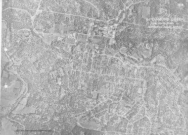
Work on paper (Sub-Item) - Aerial Photograph, Diamond Creek from Yarra River to Wattletree Road, Eltham
... Diamond Creek from Yarra River to Wattletree Road, Eltham... the central place of Eltham township marked inluding Yarra River, Main... Study, 1980 Diamond Creek from Yarra River to Wattletree Road ...Black and white aerial photograph witrh key features around the central place of Eltham township marked inluding Yarra River, Main Road, Bridge Street and Ryans Road, Eltham North land development, real estate, aerial view, eltham, eltham north -
 Eltham District Historical Society Inc
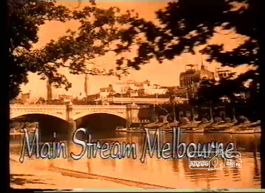
Film - Video (VHS), Screen Sound Australia, Main Stream Melbourne - The River Yarra on film and The Prize by Tim Burstall, 2004
... Main Stream Melbourne - The River Yarra on film and The...yarra river...Main Stream Melbourne - The River Yarra on film (Screen... melbourne Main Stream Melbourne - The River Yarra on film (Screen ...Main Stream Melbourne - The River Yarra on film (Screen Sound Australia, 2004) and The Prize (Eltham Films, Tim Burstall ,1960) Combining footage from more than 90 early newsreels, documentaries and short films which additionally features almost 200 photographs and illustrations - shows locals fishing and swimming in the river, holding canoe races and lazing at boathouses. Also included is Tim Burstall's 1960 short film, The Prize, which tells the story of a boy, played by his then six-year-old son Tom, and his adventures with a kid goat. The film, shot on the Yarra, won a bronze award at the 1960 Venice Film Festival. Of specific interest, scenes from Warrandyte, Montsalvat footage from 1965, Heidelberg School Artists' Trail, Koornung School (1947) in North Warrandyte, Tim Burstall and The Prize (1960) with scenes on Brougham Street Bridge, and Yarra River scenes at Morrison's Breakwater at Eltham and the Bend of Isles at Kangaroo Ground.VHS Video cassette, 130 minutes. Converted to MP4 file format 02:16:11, 1.54GBthe prize (film), tim burstall, yarra river, warrandyte, brougham street bridge, montsalvat, bend of islands, heidelberg school artists trail, koornong school, morrisons breakwater, video recording -
 Kew Historical Society Inc
Photograph, River Yarra at Kew, circa 1953, 1953
... River Yarra at Kew, circa 1953...river yarra - kew (vic)...View of the River Yarra at Kew, photographed by Sydney... river yarra - kew (vic) View of the River Yarra at Kew ...View of the River Yarra at Kew, photographed by Sydney Walter Jackson in 1953.river yarra - kew (vic) -
![Photograph (sub-item) - Black and White, The Wonga Park ‘swimming pool’ in the Yarra River, 1940’s – now in Jumping Creek Reserve (1985) [This may be the swimming pool in Jumping Creek Reserve or may be the swimming pool in Clifford Park in use in the 1948-9 Pan-Pacific Jamboree]](/media/collectors/5c7716e021ea6a1a60039fee/items/631b95b3d61f455ba20ef2cb/item-media/631b961fd61f455ba20ef417/item-fit-380x285.jpg) Wonga Park Community Cottage History Group
Wonga Park Community Cottage History GroupPhotograph (sub-item) - Black and White, The Wonga Park ‘swimming pool’ in the Yarra River, 1940’s – now in Jumping Creek Reserve (1985) [This may be the swimming pool in Jumping Creek Reserve or may be the swimming pool in Clifford Park in use in the 1948-9 Pan-Pacific Jamboree]
... The Wonga Park ‘swimming pool’ in the Yarra River, 1940’s...THE ROSE SERIES P. 922 SWIMMING POOL, RIVER YARRA, WONGA... SWIMMING POOL, RIVER YARRA, WONGA PARK, VIC. The Wonga Park ...THE ROSE SERIES P. 922 SWIMMING POOL, RIVER YARRA, WONGA PARK, VIC. -
 Kew Historical Society Inc
Photograph - Yarra Valley Floods: Kew East, 1916
... yarra river... of the Yarra River are recorded to have occurred in 1891, 1901, 1916...Verso: "Floods / Yarra River / East Kew / Kilby Road / 1917..., was a regular occurrence. Extreme flood events of the Yarra River ...Flooding of the Yarra Valley, including that section of the Yarra bordering Kew and Kew East in the north and west of the municipality, was a regular occurrence. Extreme flood events of the Yarra River are recorded to have occurred in 1891, 1901, 1916, 1923 and 1934. The Municipality of Kew's response to these floods was to enact planning decisions restricting residential development in flood prone areas following the floods of 1916, 1921 and 1934. While floods continued after the development of the Upper Yarra Reservoir (construction 1948-57), the regularity and extent of these inundations diminished. During the nineteenth century, the land abutting the south side of the Yarra in Kew was devoted to dairy farming. In the twentieth century, before and after the construction of the Eastern Freeway, much of this low-lying area was used as golf courses and public parks.One of a collection of photographs of flooding in the Kew section of the Yarra Valley which are in important research resource for the location and extent of flooding in the first half of the twentieth century. Flooding of the Yarra Valley at East Kew in 1916. The view is taken from a street (maybe Birdwood Avenue) intersecting with Kilby Road looking northeast across the flood waters to Ivanhoe and Heidelberg. The extensive flooded area shown in the photograph would have included remnant dairy farms and the Kew Golf Club. Verso: "Floods / Yarra River / East Kew / Kilby Road / 1917? / 87"yarra river, yarra valley, floods -- kew, kilby road -- kew (vic.), kew golf club -
 Kew Historical Society Inc
Postcard, River Yarra near Macauleys' Boathouse Kew, c.1910
... River Yarra near Macauleys' Boathouse Kew...bridges - yarra river -- kew (vic.)...Obverse: "River Yarra near Macauleys' Boat House Kew... reconstructed. bridges - kew (vic.) bridges - yarra river -- kew (vic ...The Pipe Bridge was constructed to bring fresh water from Fairfield to Kew. This bridge was destroyed in the 1934 Flood and later reconstructed.Early sepia real photo postcard of the first Pipe Bridge bringing water from the Yan Yean Reservoir to Kew. The site is upriver of the original Macauley's boathouse. Obverse: "River Yarra near Macauleys' Boat House Kew". Reverse: "(Pipe Water Line) / Kew to Fairfield above boat house / Pipe Bridge / Received from L. Bennett 1980".bridges - kew (vic.), bridges - yarra river -- kew (vic.), pipe bridge -
 Kew Historical Society Inc
Photograph - River Yarra in Flood from Kilby Road
... River Yarra in Flood from Kilby Road... of the Yarra River are recorded to have occurred in 1891, 1901, 1916...Print copy of an original photo of the River Yarra in Flood..., was a regular occurrence. Extreme flood events of the Yarra River ...Flooding of the Yarra Valley, including that section of the Yarra bordering Kew and Kew East in the north and west of the municipality, was a regular occurrence. Extreme flood events of the Yarra River are recorded to have occurred in 1891, 1901, 1916, 1923 and 1934. The Municipality of Kew's response to these floods was to enact planning decisions restricting residential development in flood prone areas following the floods of 1916, 1921 and 1934. While floods continued after the development of the Upper Yarra Reservoir (construction 1948-57), the regularity and extent of these inundations diminished.Print copy of an original photo of the River Yarra in Flood, taken from Kilby Road.VIEW ACROSS YARRA IN FLOOD / FROM KILBY RD KEWkilby road, floods -- kew (vic.), kilby farm -
 University of Melbourne, Burnley Campus Archives
Photograph - Sepia Print, 4. View of River Through Fence
... yarra river...Yarra River.... Boulevard Richmond melbourne yarra river mrs. jessep alexander ...Yarra River.Labelled, " View of River through fence."yarra river, mrs. jessep, alexander william jessep, principal, a.w. jessep -
University of Melbourne, Burnley Campus Archives
Photograph, James Leslie Provan, Burnley 1942 Album Page 2, 1942-1943
... yarra river...View of Yarra River from Yarra Boulevard.... Boulevard Richmond melbourne yarra river yarra boulevard burnley ...View of Yarra River from Yarra Boulevard.yarra river, yarra boulevard, burnley, 1942, j.l. provan -
Port Melbourne Historical & Preservation Society
Photograph - Shipping using Webb Dock, Williamstown and various River Yarra berths, Ron Laing, 1986 - 1999
... Shipping using Webb Dock, Williamstown and various River..., Williamstown, various river berths and movements in the Yarra River..., Williamstown, various river berths and movements in the Yarra River ...A set of 83 photographs of shipping using Webb Dock, Williamstown, various river berths and movements in the Yarra River 1986-1999mairangi bay, columbus australia, michigan highway, anro australia, toyofuji 8, columbus america, union rotoma, searoad tamar, antwerpen, contship jork, queensland star, kha bhum, columbus new zealand, city of port melbourne, dock express ii, direct kea, samas spirit, arafura, contship action, searoad mersey, ville de capella, australia bridge, juthia bhum, direct eagle, columbia star, torrons, hakuyou maru, berlin express, tourcoing, rabelis, bass trader, zim brisbane, australian advance, sea venus, morning light, matilda bay, ooclexporter, qiutte, lloydiana, direct kookaburra, nichigon maru, era, golden crux ii, canopus, stolt sincerity, ionikos, iron gippsland, ehjin, satucket, irene, paum monarch, torbon spirit, cgm, la perouse, amvella, transport - shipping, piers and wharves, ron laing, eclipse -
 Kew Historical Society Inc
Postcard, River Yarra, Kew, 1918-1930
... River Yarra, Kew...river yarra - kew...Colour-tinted postcard of the River Yarra at Kew, showing... significant in the period in which they were produced. river yarra ...The Kew Historical Society's postcard collection includes views of Kew, Melbourne and Greater Melbourne as well as those including overseas scenes sent or received from Europe or the Middle East. They date from the 1890s to the 2000s. These postcards may or may not include the name of the publisher or printer. A number of the cards were published as parts of popular series. A way of dating early postcards is to identify whether the reverse was divided by a central line which became the norm after 1902 in the United Kingdom. However, other postcards produced after this date do not always conform to this print layout.The item forms part of the Laurie Bennett collection of thirty-six postcards and photographs of Kew and early Melbourne, donated to the Kew Historical Society in 1980. The postcards in the Bennett collection, like other images in the Society's holdings date from the 1890s to the present and comprehensively indicate points-of-view or scenes considered historically, aesthetically or socially significant in the period in which they were produced.Colour-tinted postcard of the River Yarra at Kew, showing the Kew Lunatic Asylum in the distance.KH-395 .Donated by L. Bennett, 1980river yarra - kew -
Port Melbourne Historical & Preservation Society
Photograph - Sandridge railway bridge over Yarra River, Melbourne, Douglas Smallpage, 1970s
... Sandridge railway bridge over Yarra River, Melbourne... in Melbourne Photograph Sandridge railway bridge over Yarra River ...B&W photos of various locations in Port Melbourne Sandridge railway bridge over Yarra in MelbourneSeveral have descriptions of locations in pencil on rear of photostransport - railways, sandridge railway -
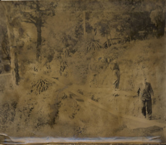 Kew Historical Society Inc
Photograph - Men on the bank of the Yarra River, circa 1953
... Men on the bank of the Yarra River... on the bank of the Yarra River Australia Victoria Melbourne ...This is one of a series of 17 black and white undated photographic proofs donated to the Kew Historical Society in 2013 by the Queenscliffe Historical Museum. The series includes images of individuals, tea rooms, ferries, motor launches, ocean liners and tugs. The subject of the photograph is a Hicks Bros ferry, which from circa 1921 operated a ferry service from Princess Walk (Melbourne) to Studley Park.Very faded and degraded photograph of a group of men walking down pathways on the bank of a river in Melbourne. The location may be the Hawthorn Tea Rooms. The undated photographic positive was probably taken in the 1950s.melbourne, tourism -
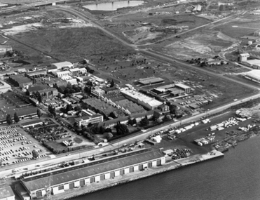 Port Melbourne Historical & Preservation Society
Photograph - Aerial view of Aeronautical Research Laboratories site from Yarra River, Early 1970s
... Yarra River... of Aeronautical Research Laboratories site from Yarra River Aeronautical ...transport - aviation and aerodrome -
 Kew Historical Society Inc
Photograph, Marnie McLeod, Floods of the River Yarra at Kew, 1916
... Floods of the River Yarra at Kew...river yarra...Inscription on reverse in pencil: "Flood River Yarra Kew... in the collection. Together with our original MMBW River Yarra map showing ...The donation was accompanied by the following letter from the donor: "Hi. I found these in with family photos. Taken by family as Mamie McLeod was living in Fellows Street, Kew, so would be near there. Retain (or discard) as you see fit." [Donor's name and address withheld from public view]. To gain an insight into the flood levels at Kew, it is worth reading newspaper accounts of the event. The Age published an article - Valuable Gardens Destroyed at Kew - on 25 September 1916: "VALUABLE GARDENS DESTROYED AT KEW. From the heights of Studley Park, Kew, a splendid view of the flood waters can be obtained, and yesterday afternoon, despite continuous rain, crowds of citizens assembled there to witness the spectacle. There is a vast stretch of water some 300 or 400 yards broad, above the foot bridge connecting Gipps-street, Collingwood, and Studley Park. The river is only about 3 feet from the top of the embankment connecting with the ramp of the bridge on the Studiey Park side. When the upper llood waters come down it is almost a certainty that tne embankment will be submerged and the bridge rendered impassible. Below the bridge the waters again stretch out, and have submerged all the low-lying land on the Collingwood side and invaded the back premises ot the Kodak Co., Phoenix Biscuit Factory, a tannery adjoining thereto, the Shamrock Brewery, and Chinese gardens in the vicinity. At Walmer-street-bridge, at the end of Studley Park, the low-lying land on the Kew side is covered with water to the depth of many feet. Tlie land in question is owned in a great part by Mr Frank Lavers who haa gone in for intense culture on a pretty liberal scale on both the slopes of the hill and on the river flat. On the latter he is cultivating many acres of asparagus, and has at a considerable cost spent three years in preparing the ground and installing an irrigation system, reticulated from the Yan Yean water supply. This year the asparagus was put down, and the plants were in a promising condition. Tlie flood waters are now flowing fast over the land. The crop is ruined, and three years' work and expenditure destroyed. Mr. Laver's private residence fortunately is high above flood level, but two houses he owns off Young-street have been flooded out. Having been warned in time, the tenants removed their furniture hefore the water came down to Mr. Laver's residence, where they themselves have been given accommodation in the meantime. All the river flats in East Kew are under water. One or two low-lying houses have been flooded. Chipperfield's boat shed at Willsmere is nearly covered, and some Chinese gardens in the vicinity are several feet under water."This, and the other three photographs donated of floods in Kew are believed to be the earliest in the collection. Together with our original MMBW River Yarra map showing flood levels, these items, when compared allow researchers to gain a visual perspective of the extent of the flood in 1916. Black and white photograph of flooded trees in Kew with rising dry ground in distance.Inscription on reverse in pencil: "Flood River Yarra Kew Vic"river yarra, kew, floods 1916 -
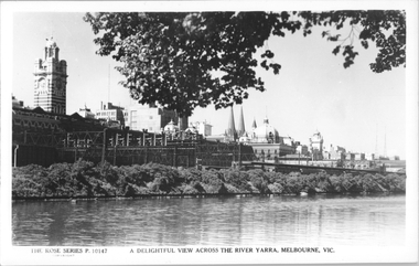 Melbourne Tram Museum
Postcard, Rose Stereograph Co, "A delightful view across the River Yarra, Melbourne"
... "A delightful view across the River Yarra, Melbourne"...Yarra River... across the River Yarra, Melbourne" showing a view from the south... the River Yarra, Melbourne" showing a view from the south bank ...Rose Series postcard No. P 10147, titled "A delightful view across the River Yarra, Melbourne" showing a view from the south bank of the Yarra across to Flinders St station, the signal gantries at the west end of the platforms, the station buildings and some of the other buildings on the skyline. A St Kilda bound dog box (swing door) set is in platform 10 awaiting departure.Yields information Flinders St station from the south side of the river.Postcard - printed real photograph with Rose Stereograph Co. name on the rear.flinders st station, signals, yarra river, railways, electric trains -
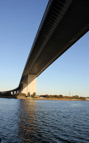 Ballarat Heritage Services
Digital photographs, L.J. Gervasoni, Under the west gate, c2016
... yarra river...Yarra River, Melbourne, Victoria, Australia... Office goldfields yarra river melbourne West Gate West Gate ...yarra river, melbourne, west gate, west gate bridge, bridge -
 Kew Historical Society Inc
Photograph - Burgess House, Victoria Street (Abbotsford), 1880-1900
... yarra river -- floods...Major floods recurred of the Yarra River on a regular basis... Burgess on the south side of Yarra River. The buildings were... Major floods recurred of the Yarra River on a regular basis ...Major floods recurred of the Yarra River on a regular basis. A flood in 1901 destroyed this house in Victoria Street, Abbotsford. Later print copy of an original photograph. Home of C/N Burgess on the south side of Yarra River. The buildings were washed away in a flood in 1901 The house was in the same location as that on which Handley & Tilly was later built. This would locate it on the north side of Victoria Street, Abbotsford between Burnley Street and the Victoria Street Bridge. Photo shows three men and one woman working in an established garden in front of a weatherboard cottage."Home of C/N Burgess on south side of river; washed away in 1901; Handley & Tilly on site"yarra river -- floods, yarra river flood -- 1901, burgess family -- victoria street -- abbotsford (vic.) -
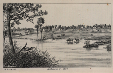 Federation University Historical Collection
Image, John Helder Wedge, Melbourne in 1838, 1938
... yarra river... bank of the Yarra River and established the first permanent... of the Yarra River. ... yarra river john helder wedge Image of the fledgling town ...The following information is from http://melbourneday.com.au/about.html, accessed 30 August 2016 Melbourne was founded on 30 August 1835 by settlers who sailed from Van Diemen’s Land (Tasmania) aboard the schooner Enterprize. They landed on the north bank of the Yarra River and established the first permanent settlement, close to where the Immigration Museum at the Old Customs House — on the corner of William and Flinders Streets — stands and the place today known as Enterprize Park. Melbourne Day Committee was established to help correct the record about the founding of Melbourne and celebrate its anniversaries. The settlers came from Launceston in search of sheep-grazing land. Land had become expensive and there had long been stories told by whalers and sealers working in Bass Strait of fertile land to the north. This was the southern part of the colony of New South Wales, which the Colonial Government did not want settled at that time. After the Henty family crossed Bass Strait and settled at Portland in 1834 others quickly followed. The north bank was chosen because a small waterfall, or rapids, stopped further progress up the river. The waterfall also separated the tidal movement, providing a vital supply of fresh water. The site had previously been noted by the colony of New South Wales' surveyor, Charles Grimes, in 1803. The north bank also offered more stable, suitable ground. The people of the Kulin nation are the traditional owners of the land that became Melbourne — including the Boonwurrung, Woiwurrung, Taungurung and Djadjawurrung people, who gathered in this place for ceremonies and cultural activities. The topsail schooner Enterprize you see today is a full-size replica of the one that brought the settlers and has become a symbol of Melbourne Day. Her keel was laid at Polly Woodside Maritime Museum in 1991, and the $2.5 million, 27m vessel was launched by Felicity Kennett on 30 August, 1997, at Hobsons Bay. The original ship was bought by John Pascoe Fawkner in April 1835 specifically to search for a suitable place for a settlement in the Port Phillip District. After helping establish Melbourne, the original Enterprize continued operating as a coastal trading vessel for a number of years. She eventually disappeared off the shipping register in 1847, having been wrecked on a sand bar in the Richmond River in northern NSW, with the loss of two lives. The replica is managed by the Enterprize Ship Trust, a not-for-profit organisation. The first settlers were those on board the Enterprize — her crew and passengers. They were John Lancey , master mariner and Fawkner’s representative; Enterprize's captain, Peter Hunter; George Evans, plasterer/builder; carpenters William Jackson and Robert Hay Marr; Evan Evans, George Evans’ servant; and Fawkner’s servants ploughman Charles Wise, general servant Thomas Morgan, blacksmith James Gilbert and his pregnant wife, Mary. And Mary's cat! Enterprize set sail on her historic voyage from Launceston on July 21, 1835, stopping at George Town in northern Tasmania where creditors detained Fawkner. He was therefore not part of the first trip to Melbourne. Enterprize then left on August 1 under the command of captain Hunter. The expedition was led by Lancey, Fawkner's delegate. The party first considered Western Port and the eastern side of Port Phillip for a place to settle, before deciding on the Yarra’s north bank — known today as Enterprize Park. On Sunday, August 30, they disembarked and began to erect shelter, build a store and clear land to grow food, thus starting the permanent European settlement of Melbourne.Image of the fledgling town of Melbourne on the banks of the Yarra River. melbourne, yarra river, john helder wedge -
 Kew Historical Society Inc
Photograph - Flood at Fairfield Park, 1934
... river yarra... of the Yarra River are recorded to have occurred in 1891, 1901, 1916...Black and white print positive. Yarra River at Fairfield..., was a regular occurrence. Extreme flood events of the Yarra River ...Flooding of the Yarra Valley, including that section of the Yarra bordering Kew and Kew East in the north and west of the municipality, was a regular occurrence. Extreme flood events of the Yarra River are recorded to have occurred in 1891, 1901, 1916, 1923 and 1934. The Municipality of Kew's response to these floods was to enact planning decisions restricting residential development in flood prone areas following the floods of 1916, 1921 and 1934. While floods continued after the development of the Upper Yarra Reservoir (construction 1948-57), the regularity and extent of these inundations diminished.Black and white print positive. Yarra River at Fairfield in 1934. Major flood resulting in submerged buildings in middle ground and onlookers on far bankReverse: "Flood of Yarra at Fairfield Park 1934"fairfield park, yarra valley, river yarra, floods -- 1934 -
 Wonga Park Community Cottage History Group
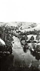
Photograph (sub-item) - Black and White, A view of the Yarra River from Wonga Park in 1929. [Mt Lofty in background, house is Mr. Witton’s ‘Crooning Waters’ at the confluence of Brushy Creek and Yarra River and what was to become Witton’s Reserve to the right
... A view of the Yarra River from Wonga Park in 1929. [Mt... Old Yarra Road Wonga Park melbourne A view of the Yarra River ...