Showing 2370 items
matching 1859/1883
-
 Federation University Historical Collection
Film, Ballarat School of Mines Council Minutes Microfilm, 1883-1918, 1883-1918
Digitised files from a mirofilm of the Ballarat School of Mines Council Minutesballarat school of mines, council, microfilm -
Glenelg Shire Council Cultural Collection
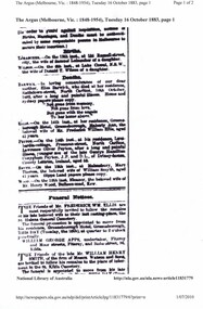
Book - Victorian Government Gazette, Victorian Government Gazette 1, 1883. 1 January - 30 June, 1883
Dark green marbled fabric over hard cardboard, with leather corners and spine. Gold lettering and crown on black band on spine. -
 Greensborough Historical Society
Newspaper Clipping, Argus (newspaper), Death notice of Mrs Ellis 16 October 1883, 16/10/1883
Death and funeral notices for Mrs Maberly Ann Ellis, wife of Frederick William Ellis of Greensborough Hotel.Print of death and funeral notice from The Argus.ellis family -
 Federation University Historical Collection
Book, John Ferres, Government Printer, Eucalyptographia : a Descriptive Atlas of the Eucalypts of Australia and Adjoining Islands, 1883-4, 1883 and 1884
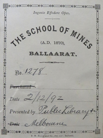
Ferdinand Von Mueller was the Government Botanist for the Colony of Victoria. He was an early examiner in Botany at the Ballarat School of Mines. The book was donated to the Ballarat School of Mines by the Melbourne Public Library. The Bookplate in the front states the book is number 1278 in the Ballarat School of Mines Library and was presented on 02/12/1892.Two books (ninth and tenth decade) with soft cover and blue tape spine. Includes text and black and white images relating to Eucalypts .1) includes a bookplatebotany, ferdinand von mueller, ballarat school of mines, eucalypts, botanist, bookplate, melbourne public library, state library of victoria -
 Federation University Historical Collection
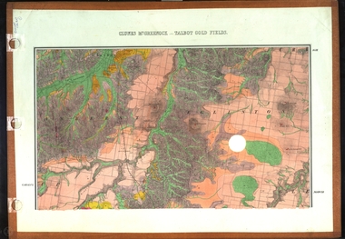
Map, Clunes, Mt Greenock, and Talbot Gold Fields, 1883, 1883
A geological plan of the Clunes, Mt Greenock, and Talbot Gold Fields in two parts. .1) This section of the map includes Talbot, Talbot water supply race, Mt Glasgow, Little Green Hill, Middle Hill, Mt Cameron, Ballarat Hill, Bakery Hill, Goodwoman Hill, Scandanavian Lead, Eglinton Swamp, McCallum's Creek, Tullaroop Creek, Dunach, Maryborough Railway, Middle Creek and includes many mines such as Rip Van Winkel, Union Extended, South Greenock, Nicholl's Freehold. .2) This section of the map includes McCallums, Clunes, Green Hill, Mt Beckworth, Mt Gap, Maryborough Reservoir, and includes mines such as Lothair, Bute, Clyde, Clunes Consols, London and Australian, Oriental,clunes, talbot, water supply, railway, geology -
Federation University Historical Collection
Book - Book - Ledger, Ballarat School of Mines Council Minute Book,1883-1888, 1883-1888
Hardcovered book, quarter leather bound containing handwritten minutes of the Ballarat School of Mines Council. 27 July 1887 - proposal for lectureship in Mechanical Photographyballarat school of mines, ballarat school of mines council, ballarat school of mines council minutes, theo williams, samual e. figgis, thomas mann, frederick martell, j.m. bickett, james oddie, alfred mica smith, ferdinand krause, nicholls, e.j. rosemblum, w.r. bechervaise, barbara ramsay, lizzie clarke, mary burrows, matilda latter, fiddian, w.h. nicholls, henry r. caselli, e. rosenblum, thornton, williams, john b. irwin, joan rosenblum, gredrick given, william mcdougall, alexamder reid, william legg, tennis, c.h. ellis, h. bradbury, i.j. jones, j. lonie, agar wynne, fanny trebilcock, wmily h. walker, james lonie, william davies, edwin blomeley, charles walker, charles nicholls, william manners, john scott, george cairns, alfred kerr, h.w. bull, astronomy, g. wilkins, electricity, frederick gray, e.h. coltman, maggie gilchrist, w. sharwood, e.j. rosenblum, surveying, a.f. laplau, r. ghee, a. bragazzi, oscar skoglund, mine manager, r.f. taplin, j.w. sutherland, william cotter, w.j.gronow, e. wilfred robinson, adelaide jubilee exhibition, mechanical photography lectureship, photography, university of melbourne, john warrington rogers, william john clarke, rivett henry blandalfred lynberg, hugh reid resignation, mary ann cameron, mary jane guthrie, maude louisa millett, harry mortimer martell, r.j. vale, mining laboratory -
Federation University Historical Collection
Book, W. & R. Chambers, Treatise on Practical Mathematics, 1883, 1883
Brown hardcovered book of 536 pages.Stamped inside front cover "Presented to the School of Mines, Ballarat by Professor A. Mica Smith, 1926."mathematics, alfred mica smith -
Federation University Historical Collection
Book, J.A. Churchill, An Introduction to Physical Measurements, 1883, 1883
Dick Richards was Principal of the Ballarat School of Mines Dark green hard covered book of 344 pages (and catalogue).Signed inside cover "R.W. Richards".r.w. richards, dick richards, physics, friedrich wilhelm georg kohlrausch -
 Beechworth Honey Archive
Publication, e-book, The bee-keepers' guide or manual of the apiary (Cook, A. J.), Lansing, 1883, 1883
-
 Clunes Museum
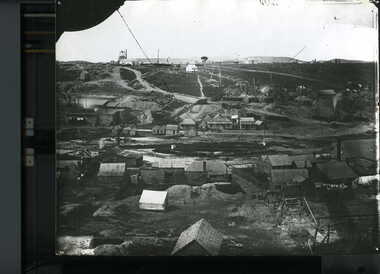
Photograph, 1859
.1.2 BLACK AND WHITE PHOTOGRAPH OF PORT PHILLIP HILL TAKEN CIRCA 1859. .1 HANDWRITTEN ON BACK: PORT PHILLIP MINE AND HILL TAKEN CIRCA 1859 PORT PHILLIP MINE SOUTH SHAFT CLUNES HOTEL IN MIDDLE OF P.P. PADDOCK CLUNES UNITED MINE CRITERIAN MINE CRITERIAN BRIDGE WOOSTERS BALLARAT RESTAURANT, DOES NOT SHOW IN LATER PICTURES PORT PHILLIP MINE FIRST BATTERY PORT PHILLIP HOTEL OPENED IN 1859, CONTINUED UNTIL LATE 1890'S CRITERION HOTEL, FIRST MASONIC MEET UP, BURNT JAN 1871 NEGATIVE OF THIS PHOTO IS AT LATROPE LIBRARY MELBOURNE SIGNED: J CONRAD WEICKHARDT .2 HANDWRITTEN ON BACK: PHOTO OF PORT PHILLIP MINE AND HILL TAKEN ABOUR 1859 OR 1860 THE NEGATIVE OF THIS PICTURE IS AT LATROBE LIBRARY MELBOURNE FROM CAMP PARADE photography, mining, port phillip hill, port phillip -
 Bacchus Marsh & District Historical Society
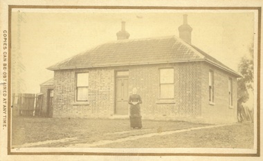
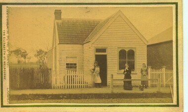
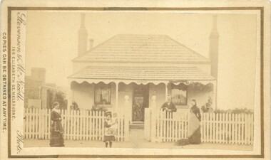
Photograph, James Reid House Bacchus Marsh 1883
James Reid was born in Scotland near Glasgow and came to Victoria as a young man in 1854. Shortly after arriving he came to Bacchus Marsh where he lived until his death in 1902 at the age of 74 years. For most of these years he conducted a wheelwrights and coach builders business in Bacchus Marsh. In the nineteenth and early twentieth centuries, wheelwrights and blacksmiths played an essential role in the functioning of the whole community. Before the industrialisation of manufacturing, wheels and other components of vehicles for transport, all metal objects, including farm implements, building requirements and domestic utensils were made by hand. As mechanisation of industry increased, the smith commonly performed the role of farrier in the times when horse power was pivotal to all aspects of society. Small sepia unframed photograph on card with gold border framing photograph. Housed in the album, 'Photographs of Bacchus Marsh and District in 1883 by Stevenson and McNicoll' The photo shows a plain brick house with a central front door with a window on either side. There are a further two windows along the side of the house. On the left-hand side of the building there is a smaller room with its own entry door. The main roof is tiled with shingles or slate and features two substantial chimneys. At the front of the house stands a young woman with her hands clasped. A horse can be seen at the rear of the house. From the photo of the James Reid Wheelwright and Blacksmith Shop, Victorian Collections No.VC 618, we know that this house stood to the rear of the workshop. The wheel tracks which can be seen lead out to Main Street. On the front: Stevenson & McNicoll. Photo. 108 Elizabeth St. Melbourne. COPIES CAN BE OBTAINED AT ANY TIME. On the back: LIGHT & TRUTH inscribed on a banner surmounted by a representation of the rising sun. Copies of this Portrait can be had at any time by sending the Name and Post Office Money Order or Stamps for the amount of order to STEVENSON & McNICOLL LATE BENSON & STEVENSON, Photographers. 108 Elizabeth Street, MELBOURNE houses bacchus marsh, stevenson and mcnicoll 1883 photographs of bacchus marsh and district, james reid 1828?-1902, wheelrights bacchus marsh -
 Bacchus Marsh & District Historical Society
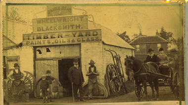
Photograph, James Reid's Wheelwright and Blacksmith's Shop 1883
James Reid was born in Scotland near Glasgow and came to Victoria as a young man in 1854. Shortly after arriving he came to Bacchus Marsh where he lived until his death in 1902 at the age of 74 years. For most of these years he conducted a wheelwrights and coach builders business in Bacchus Marsh. In the nineteenth and early twentieth centuries, wheelwrights and blacksmiths played an essential role in the functioning of the whole community. Before the industrialisation of manufacturing, wheels and other components of vehicles for transport, all metal objects, including farm implements, building requirements and domestic utensils were made by hand. As mechanisation of industry increased, the smith commonly performed the role of farrier in the times when horse power was pivotal to all aspects of society. Complementing this work, the forge was often allied with a wheelwright's shop. These premises also acted as a meeting place for the men of the town, where news was shared and friendships forged.Small sepia 'carte de viste' style unframed photograph on card with gold border framing photograph. Housed in the album, 'Photographs of Bacchus Marsh and District in 1883 by Stevenson and McNicoll'. An image depicting a wheelwright and blacksmith's shop, with a group of men, boys and a woman shown in front. Two men are wearing the work clothes of the blacksmith, including the split leather apron worn by farriers to enable them to work on the hooves of the horses needing shoeing. Two young boys are standing by the door. A portly gentleman in formal clothes stands before the shop. The house shown at the rear was James Reid's residence. Two people, an elderly gentleman and a younger woman, are seated in a jinker on the road to the side of the shop. A collection of wheels and farm tools leans on the walls. A triple-tiered sign above the shop reads: JAMES REID WHEELWRIGHT BLACKSMITH. TIMBER - YARD PAINTS, OILS & GLASS.Printed On the front: Stevenson & McNicoll. Photo. 108 Elizabeth St. Melbourne. COPIES CAN BE OBTAINED AT ANY TIME. On the back: LIGHT & TRUTH inscribed on a banner surmounted by a representation of the rising sun. Copies of this Portrait can be had at any time by sending the Name and Post Office Money Order or Stamps for the amount of order to STEVENSON & McNICOLL LATE BENSON & STEVENSON, Photographers. 108 Elizabeth Street, MELBOURNE.wheelwrights, james reid 1828?-1902, stevenson and mcnicoll 1883 photographs of bacchus marsh and district -
 Bacchus Marsh & District Historical Society
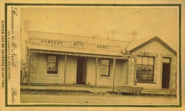
Photograph, Harvest Home Hotel Main Street Bacchus Marsh 1883
The Harvest Home Hotel was licensed as a beer shop in 1866. Patrick Vallence was the licensee. On his death in 1874 his widow Mrs M. A. Vallence obtained the license. At the time this image was taken George Marshall was leasing the hotel. Following a decrease in the population of Bacchus Marsh, by 1911 the hotel had lost its licence.The Vallence family still owned the building after the loss of the hotel licence in 1911and it was used for some years after this as a private residence by some members of the Vallence family. Small sepia unframed photograph on card with gold border framing photograph. Housed in the album, 'Photographs of Bacchus Marsh and District in 1883 by Stevenson and McNicoll', the Jeremeas Family Album. The image depicts the Harvest Home Hotel situated in Main Street Bacchus Marsh. The name of the hotel can be seen above the verandah roof. The building appears to be of stone with decorative stonework corners. A verandah is inset to the left of a gabled front section which has its own door and window. On either side of the door beneath the verandah can be seen boot or shoe scrapers. A deep gutter runs along the front of the hotel, with a slab acting as a bridge to the road. Situated in the gutter at the front of the hotel is a water trough which has an arch above it with an ornate lantern, probably to light the front entry and to enable horses to be watered at night. A hitching post is nearby.On the front: Stevenson & McNicoll. Photo. 108 Elizabeth St. Melbourne. COPIES CAN BE OBTAINED AT ANY TIME. On the back: LIGHT & TRUTH inscribed on a banner surmounted by a representation of the rising sun. Copies of this Portrait can be had at any time by sending the Name and Post Office Money Order or Stamps for the amount of order to STEVENSON & McNICOLL LATE BENSON & STEVENSON, Photographers. 108 Elizabeth Street, MELBOURNE. hotels bacchus marsh, stevenson and mcnicoll 1883 photographs of bacchus marsh and district, vallence family bacchus marsh, harvest home hotel bacchus marsh -
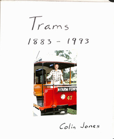 Melbourne Tram Museum
Album - Photo Album, Colin Jones, "Trams 1883 - 1993", 1990's
Photo Album, grey decorative front cover with a grey heavy card slip case, 30 leaves of heavy paper, each separated by a semi clear protective sheet. Compiled by Colin Jones with a title sheet "Trams 1883 - 1993" with Colin standing in the front of Brisbane Tramway Co. No. 47 at the Ferny Grove Museum. Bound with end papers. Photos retained by clear photo corners. Features photos by Colin of: Victor Harbor Surabaya Indonesia Melbourne cable trams, Sydney Steam tram in the UK Ballarat Bangkok Semarang Indonesia Adelaide Brisbane Melbourne Sydney Bendigo Launceston Osaka Japan Perth Kyoto Dalian Japan Fukuoka Japan Kanazawa Japan Hong Kong Sendai Kita Kyushu Hobart Lopburi Kobe Hiroshima Tokyo Matsuyama Japan Nagaski Various Museums in Australia. Sample pages only scanned.trams, tramways, melbourne, album, japan, indonesia, australian tramways -
 Bacchus Marsh & District Historical Society
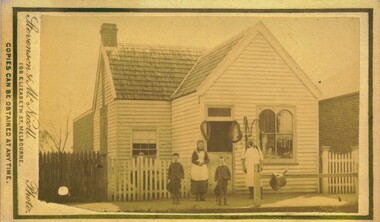
Photograph, Thomas Heath's Saddlery Main Street Bacchus Marsh 1883 Image 2
Thomas Heath built this shop for his saddlery business around 1875. In 1926 after 58 years operating his saddlery in Bacchus Marsh he retired and the assets of his business were sold in a clearing sale. The building was located close to the current day location of 192 Main Street and has been demolished. Apart from his services in saddlery his premises was known to be a gathering place for much discussion. Heath was known to openly express his political opinions and his saddlery premises was known by many in the community as the 'Parliament'.Small sepia unframed photograph on card with gold border framing photograph. Housed in the album, 'Photographs of Bacchus Marsh and District in 1883 by Stevenson and McNicoll'. The photo is of a double-fronted weatherboard building with a shingle roof. The front gabled section stands directly on street level and is flanked by a picket fence. The door and overhead window and the side window with arched panels may indicate that this was the shop section, with a dwelling to the rear. The recessed side section of the building with a twelve-sectioned window, chimney and a back extension was probably the dwelling used by the family. In the doorway stands the saddler, probably Thomas Heath. To his left is a woman, possibly Mrs Heath, and a much younger woman, possibly a daughter of the Heaths. In front of the two women is a small dog. A hitching rail runs along the front of the workshop. Indicating the type of business Mr Heath ran. On the front: Stevenson & McNicoll. Photo. 108 Elizabeth St. Melbourne. COPIES CAN BE OBTAINED AT ANY TIME. On the back: LIGHT & TRUTH inscribed on a banner surmounted by a representation of the rising sun. Copies of this Portrait can be had at any time by sending the Name and Post Office Money Order or Stamps for the amount of order to STEVENSON & McNICOLL LATE BENSON & STEVENSON, Photographers. 108 Elizabeth Street, MELBOURNE. saddleries, saddlers, thomas heath 1842-1930 saddler, heath family bacchus marsh, stevenson and mcnicoll 1883 photographs of bacchus marsh and district -
Clunes Museum
Document - REGISTER, KATHLEEN THOMSON AND GEOFFREY SERLE, 1922
A BIOGRAPHICAL REGISTER OF THE VICTORIAN PARALIAMENT 1859 - 1900A Biographical Register of the Victorian Parliament 1859-1900 Kathleen Thomson and Geoffrey Serle Australian University Press Canberra 1972local history, document, report, mining -
 Bacchus Marsh & District Historical Society
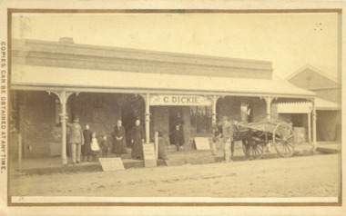
Photograph, George Dickie Bakery Main Street Bacchus Marsh 1883
George Dickie arrived in the Bacchus Marsh area around 1857. In 1863, he married Ellen Ross Anderson, and after five years of farming in Coimadai, they moved into Bacchus Marsh and established a business. In 1866 he bought the bakery business which had been established by James Boatwood and later conducted by William Watson. This business was in Main Street and is shown in this image during the time it was owned and operated by George Dickie. Ellen and George Dickie had seven children, two sons and five daughters. In his later years he changed the business into a general store and also engaged in grain dealing. He died in 1904 but the business was carried on by his sons until sold in March 1916 to a Charles Medling from Numurkah. The building was later demolished in 1927 to make way for four new shops.Small sepia 'carte de viste' style unframed photograph on card with gold border framing photograph. Housed in the Jeremeas Family Album which contains photographs of Bacchus Marsh and District in 1883 by the photographers Stevenson and McNicoll. The picture shows the business of George Dickie which was located in Main Street Bacchus Marsh. The building is a brick or stone structure with a verandah along the entire frontage of the building. Standing in front of the building is a group of adults and children. On the far left is a man wearing a dress coat and hat. He is possibly Mr. George Dickie the owner of this business. To his left are some younger and older children, and a woman, possibly Mrs DIckie. In the background in the doorway is a young boy with woman behind him. On the right of the picture on the street is a man standing alongside a horse and cart. Some advertising signs are leaning against the shop, footpath and verandah pillar. One of them says 'Chaff, Oats, Bran'. Printed On the front: Stevenson & McNicoll. Photo. 108 Elizabeth St. Melbourne. COPIES CAN BE OBTAINED AT ANY TIME. On the back: LIGHT & TRUTH inscribed on a banner surmounted by a representation of the rising sun. Copies of this Portrait can be had at any time by sending the Name and Post Office Money Order or Stamps for the amount of order to STEVENSON & McNICOLL LATE BENSON & STEVENSON, Photographers. 108 Elizabeth Street, MELBOURNE. stevenson and mcnicoll 1883 photographs of bacchus marsh and district, bakeries, shops bacchus marsh, george dickie 1831-1904, dickie family bacchus marsh -
 Bacchus Marsh & District Historical Society
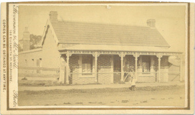
Photograph, House of Christopher Crisp Bacchus Marsh 1883
The former Christopher Crisp residence was constructed in 1868 by William Watson, one of the members of the Bacchus Marsh Express printing company which took over the management of The Express after the first edition, 7 July 1866, was published by its founder, George Lane, a book binder. This syndicate failed after three months and the ownership was then taken over by Christopher Crisp, a compositor working for the company. Crisp remained the editor from 1866 to his death in 1915, when he was succeeded by his son, also called Christopher Crisp, and later by his grandson. Under the Crisp family leadership, The Express widened its readership and was subscribed to by influential men and public servants in Melbourne. (Heritage Victoria Council. Places. Entry no. 45.)Small sepia unframed photograph on card with gold border framing photograph. Housed in the album, 'Photographs of Bacchus Marsh and District in 1883 by Stevenson and McNicoll'. The photograph is of a single-storey cottage of rendered brick and sandstone with a shingled roof of slate tiles and ornate concave verandah. A chimney stands at either end of the house. A carved barge board decorates the northern end of the hip roof. A skillion with windows and a chimney adjoins the rear of the cottage. The front facade is symmetrical with two sash windows placed either side of the central door. A wire fence runs along the front of the cottage. Standing at the gate is a formally dressed gentleman wearing a top hat. A young child is standing on the road. This child is possibly Christopher Crisp, Jnr., who later took over the role of editor of the Bacchus Marsh Express in 1915 on the death of his father. At the time of this photo, he would have been 4 years old. On the front: Stevenson & McNicoll. Photo. 108 Elizabeth St. Melbourne. COPIES CAN BE OBTAINED AT ANY TIME. On the back: LIGHT & TRUTH inscribed on a banner surmounted by a representation of the rising sun. Copies of this Portrait can be had at any time by sending the Name and Post Office Money Order or Stamps for the amount of order to STEVENSON & McNICOLL LATE BENSON & STEVENSON, Photographers. 108 Elizabeth Street, MELBOURNE. stevenson and mcnicoll 1883 photographs of bacchus marsh and district, houses bacchus marsh, christopher crisp 1844-1915 -
 Bacchus Marsh & District Historical Society
Photograph, White Cottage Young Street Bacchus Marsh 1883
This four roomed cottage with a detached kitchen was built for a Mr Elam, c. 1867. Occupants of this house among others have been Sir George Farmer, Christopher Crisp, Joseph Voysey, E. Simpson, J.R. Crook and H. Condon. It is located in Young Street and is opposite the site where the original Bacchus Marsh Mechanics Institute stood until about 1995.Small sepia unframed photograph on card with gold border framing photograph. Housed in the album, 'Photographs of Bacchus Marsh and District in 1883 by Stevenson and McNicoll'. The photograph is of a neat Georgian-style, double-fronted cottage. The hip roof and verandah are roofed with wooden shingles. Two tall chimneys stand, one at either side of the cottage, while a smaller chimney can be seen at the rear. The front verandah is decorated with carved barge boards. A white picket fence runs along the front, the entry posts featuring a carved globe-shaped finial. Standing inside the front fence is a smartly dressed gentleman, leaning on the fence. This is possibly Mr Joseph Voysey, Head Master of Bacchus Marsh Primary School 1879-1888, who purchased this cottage in 1882, the year before this photo was taken. Two women, one with a dog at her feet, stand on the footpath with a young girl holding a doll. This cottage still stands in Young Street, Bacchus Marsh.On the front: Stevenson & McNicoll. Photo. 108 Elizabeth St. Melbourne. COPIES CAN BE OBTAINED AT ANY TIME. On the back: LIGHT & TRUTH inscribed on a banner surmounted by a representation of the rising sun. Copies of this Portrait can be had at any time by sending the Name and Post Office Money Order or Stamps for the amount of order to STEVENSON & McNICOLL LATE BENSON & STEVENSON, Photographers. 108 Elizabeth Street, MELBOURNE houses bacchus marsh, stevenson and mcnicoll 1883 photographs of bacchus marsh and district -
 Bacchus Marsh & District Historical Society
Photograph, Thomas Heath's Saddlery Main Street Bacchus Marsh 1883 Image 1
Thomas Heath built this shop for his saddlery business around 1875. In 1926 after 58 years operating his saddlery in Bacchus Marsh he retired and the assets of his business were sold in a clearing sale. The building was located close to the current day location of 192 Main Street and has been demolished. Apart from his services in saddlery his premises was known to be a gathering place for much discussion. Heath was known to openly express his political opinions and his saddlery premises was known by many in the community as the 'Parliament'.Small sepia unframed photograph on card with gold border framing photograph. Housed in the album, 'Photographs of Bacchus Marsh and District in 1883 by Stevenson and McNicoll'. The photo is of a double-fronted weatherboard building with a shingle roof. The front gabled section stands directly on street level and is flanked by a picket fence. The door and overhead window and the side window with arched panels may indicate that this was the shop section, with a dwelling to the rear. Items which may be for sale can be seen hanging in the windows. The recessed side section of the building with a twelve-sectioned window, chimney and a back extension was probably the dwelling used by the family. On the footpath stands the saddler with three children, two boys and an older girl, probably Mr Thomas Heath and three of his five children. A hitching rail runs along the front of the workshop. Indicating the type of business Mr Heath ran, are a saddle placed over the rail and two horse collars and reins hanging either side of the workshop door. On the front: Stevenson & McNicoll. Photo. 108 Elizabeth St. Melbourne. COPIES CAN BE OBTAINED AT ANY TIME. On the back: LIGHT & TRUTH inscribed on a banner surmounted by a representation of the rising sun. Copies of this Portrait can be had at any time by sending the Name and Post Office Money Order or Stamps for the amount of order to STEVENSON & McNICOLL LATE BENSON & STEVENSON, Photographers. 108 Elizabeth Street, MELBOURNE. saddleries, saddlers, thomas heath 1842-1930 saddler -
 Bacchus Marsh & District Historical Society
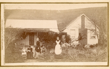
Photograph, Group of women at a farmhouse near Bacchus Marsh 1883
This image is one of several family group portraits taken by Stevenson and McNicoll on rural properties. This property has been identified as that of John Tilley at Parwan’s Creek. The people depicted are presumably members of the Tilley family. The dwelling has since been demolished. Tilleys Road in Maddingley is probably named for this family farm.Small sepia unframed photograph on card with gold border framing photograph. Housed in the Jeremeas Family Album which contains photographs of Bacchus Marsh and District in 1883 by Stevenson and McNicoll. The property has been identified as that of John Tilley at Parwan’s Creek. This property has since been demolished. Presumably, the photo is of members of the Tilley family. The image shows a family group of four women and one young child. It is unclear if the child is a boy or a girl, due to the custom of clothing young male children in dresses. The women are sitting or standing in two groups. To the right stands an older woman in a starched white apron, perhaps indicating that she is the housekeeper. The group on the left is of one woman standing and two women seated, one reading a newspaper or magazine. The young child reaches out one arm to her, perhaps for reassurance. The dwelling consists of two structures, one single storeyed cottage, which is perhaps the older part, and an adjoining weatherboard house with a steeply pitched roof and a prominent chimney at the front. The cottage has a shingled verandah partially covered by corrugated iron, which also covers the roof. Trees, a climbing vine and shrubs form a rather unkempt garden. On the hill rising behind the farmhouse there can be seen animals, possibly sheep, grazing.On the front: Stevenson & McNicoll. Photo. 108 Elizabeth St. Melbourne. COPIES CAN BE OBTAINED AT ANY TIME. On the back: LIGHT & TRUTH inscribed on a banner surmounted by a representation of the rising sun. Copies of this Portrait can be had at any time by sending the Name and Post Office Money Order or Stamps for the amount of order to STEVENSON & McNICOLL LATE BENSON & STEVENSON, Photographers. 108 Elizabeth Street, MELBOURNE. stevenson and mcnicoll 1883 photographs of bacchus marsh and district, farmhouses, families, women bacchus marsh -
 Bacchus Marsh & District Historical Society
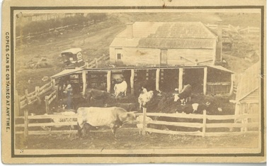
Photograph, Dairy Farm Bacchus Marsh District 1883
The number of cattle in this photo suggests that it was a small holding, at the beginning of the dairy industry in Bacchus Marsh. This industry became a major source of employment in Bacchus Marsh. By the early twentieth century, the Bacchus Marsh region was a significant contributor to the dairy industry in Australia. Small sepia unframed photograph on card with gold border framing photograph. Housed in the album, 'Photographs of Bacchus Marsh and District in 1883 by Stevenson and McNicoll'. This is a photo of a dairy farm in an unknown location in the Bacchus Marsh district. It has been taken from an elevation looking down at the farm. On the left, the roadside can be seen running alongside a stream or river which is fenced off by a line of trees and a post and rail fence. Parked on the road outside the farmhouse is a wagon which is unhitched. The wagon has a white rooftop and on the side can be seen a professional logo, details unclear. This wagon is most likely the wagon used by the photographers to access outlying properties with their photographic equipment. The farmhouse itself faces the road with side doors giving onto the yard. The roof is partially covered by new slates, possibly slate covering bark. Six milking sheds of post-and-rail construction adjoin the farm yard. In the first and fourth stalls (l to r) the farmer and his wife can be seen seated, miking cows. The rest of the herd are awaiting milking in the yard which also has a post-and-rail fence. A bull of milking shorthorn breed stands outside the fence. The milking herd itself is of various breeds; Herefords, roan shorthorn and roan and white shorthorns can be identified. On the right is a shed of rough-hewn boards and a shingle roof. In the yard at the back of the house stands a cart or dray. On the front: Stevenson & McNicoll. Photo. 108 Elizabeth St. Melbourne. COPIES CAN BE OBTAINED AT ANY TIME. On the back: LIGHT & TRUTH inscribed on a banner surmounted by a representation of the rising sun. Copies of this Portrait can be had at any time by sending the Name and Post Office Money Order or Stamps for the amount of order to STEVENSON & McNICOLL LATE BENSON & STEVENSON, Photographers. 108 Elizabeth Street, MELBOURNE. dairy farms, stevenson and mcnicoll 1883 photographs of bacchus marsh and district -
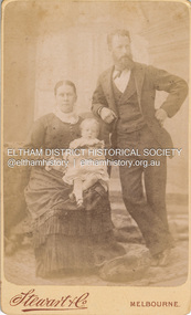 Eltham District Historical Society Inc
Photograph, Stewart & Co, Charles and Sarah (nee Shillinglaw) Aldous with either Florence May (1883) or Elizabeth Annie (1885) Aldous, c.1884-c.1887
Florence May Aldous was born 1883, her sister Elizabeth Annie was born 1 Nov. 1885 A duplicate image is contained in Album 2 (05664) Aldous family assumption was that the child was Elizabeth Annie. However upon further investigation with the original source of information written on back of a duplicate photo has confirmed in Annies hand it says “my mother and father”. Given that photo was handed down Elizabeth Annie's line, it is a reasonable presumption to have thought the child was Elizabeth Annie however it begs to question why her elder sister by two years is not in the photo. Hence it is thought the child is more likely to be Florence May. c.1885 Stewart & Co Photographers operated from various addresses in Bourke Street, Melbourne from 1871 through 1910. CARTE-DE-VISITE (cdv) 1857-1890 Cartes-de-visite (cdv's) are the most common form of photograph from the nineteenth century, generally measuring two and a half inches by four and an eighth inches (6.3 x 10.5 cm) when mounted, sepia toned, mounted on a card which was generally printed with the photographer's name and address on the back or beneath the portrait. - Frost, Lenore; Dating Family Photos 1850-1920; Valiant Press Pty. Ltd., Berwick, Victoria 1991marg ball collection, shillinglaw family photo album 1, 1884-1887, charles aldous, elizabeth annie aldous, florence may aldous, sarah aldous (nee shillinglaw 1854-1925), stewart & co photographers bourke st east melbourne, 1871-1910, 1885 -
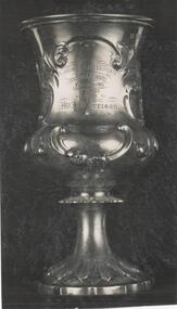 Phillip Island and District Historical Society Inc.
Photograph
One of a collection of over 400 photographs in an album commenced in 1960 and presented to the Phillip Island & Westernport Historical Society by the Shire of Phillip IslandPhotograph of the Silver Cup won by A. Morrison as Victorian Ploughman Champion 1859.Burrumbeet & Lake Learmonth Agricultural Society. Ploughing 1st Prize awarded to Mr. A. Morrison. Annual match Victoria 1859.local history, photography, silver cup, ploughing award, black & white photograph, ploughing, competitions, a morrison, john jenner, bryant west -
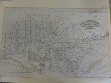 Warrnambool and District Historical Society Inc.
Map, Warrnambool 1859, Late 20th century (copy)
This is a copy of Bromfield’s 1856 map of Warrnambool and district. James Astley Bromfield was a pioneer settler in Warrnambool. He established a chemist’s shop in 1854, initially situated in Timor Street. He moved his shop to Liebig Street with a new building erected in 1875. Bromfield was a prominent resident of Warrnambool (Shire Councillor, Fire Brigade member, Cricket Club member, associated with horse racing etc). He was interested in preserving the history of Warrnambool and this map he produced in 1856 was an example of this interest.This is a copy only but this 1856 map is of prime importance as it contains the names of the original landowners of land in north Warrnambool and the surrounding district. It is a frequently-used resource by historians.This is a copy of a map of Warrnambool and its agricultural district published by James Astley Bromfield in 1856. The map is mounted on cardboard and has black printing on a white background. ‘Map of Warrnambool and its Agricultural District according to the Government Survey’s published by Astley Bromfield, Medical Hall, Warrnambool 1856, James Ferguson, Lithr., Melbne.’bromfield’s 1856, map, warrnambool and district -
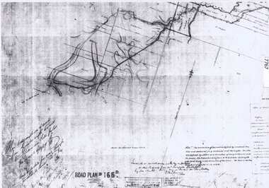 Greensborough Historical Society
Document - Road Plan, Road acquisition, St Helena Road, 1859, 1889
Road plan showing land acquisition for the road to Diamond Creek (NOT Diamond Creek Road), also known as Eltham Road and now known as St Helena Road.Shows the land through which St Helena Road runs, with original owners marked on plan.1 page. Copy of road planroad plans, st helena road greensborough, diamond creek -
Glenelg Shire Council Cultural Collection
Book, Victorian Government Gazette 2, 1859. 1 July - 31 December, 1860
Dark blue marbled cloth cover over hard cardboard. Red leather spine corners. Gold lettering on black band on spine. Gold crown and lettering on spine.local courts, local government, government administration, gazette, victorian government -
Glenelg Shire Council Cultural Collection
Book - Book - Victorian Government Gazette 2, 1859, John Ferres, Government Printer, Melbourne, Victorian Government Gazette 2, 1859. 1 July - 31 December, 1860
Dark green marbled fabric over hard cardboard. Red leather corners and spine. Gold lettering on black band on spine. Gold crown and lettering on spine. -
 Glenelg Shire Council Cultural Collection
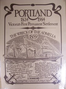
Poster - Poster - Portland 1834-1984. Wreck of the Admella 1859, Portland 1834-1984. Wreck of the Admella 1859, 1984
Possibly Portland City Council Collection.Laminated poster with illustration of a steam ship with sails, bearing name of prow "Admella". Bottom third of image has story of event in hand-written text.Front: (no inscriptions) Back: (no inscriptions) -
 Eltham District Historical Society Inc
Ledger, Eltham Road District. Assessment for the Year ending Oct. 14th, 1859, 1858c
The Eltham Roads Board was established in 1856. This ledger includes the signature of Road Board Secretary and Collector Wingrove, a significant person in Eltham's early history. This is a unique significant record of early settlers in the Shire of Eltham. One of 6 early rate books. This is among the oldest items in the EDHS collection. An article in the Eltham and Whittlesea Shires Advertiser Friday 21 Nov 1941 Page 5 titled: District's Early History states: "The first rate book which is still in existence at the Shire Office is for the year ending October 14, 1858 and is probably the best record possible to indicate the development of the district. At the time properties were rated as follows: Cultivated land. 6d. per acre; pasture land, 1d. per acre: estimated annual value of buildings, etc., 6d in the (pound). The total amount of rate recorded for the year was (pounds)153/14/8. Properties were described as being situated at Lower Plenty, Yarra Yarra, Eltham, Lower Eltham, Kangaroo Ground, Yarra Flats, Diamond Creek and the Yarra."Ledger with printed columns: Number, Name of Occupier, Description, Where situated, Cultivated land, Pasture land, Estimated annual value of buildings, Rate, Remarks, Arrears collected, excused, unoccupied, uncollected and amount actually collected. Ledger filled out by hand with 173 entries (not alphabetically arranged). A number of blank pages are included. Inside cover includes pasted printed note: RATE OF ASSESSMENT AS FOLLOWS: Cultivated land 6d per acre Pasture land 2d per acre Unalienated Pasture Land 8d per Acre Estimated Annual Value of Buildings, &c., 6d. in the Pound eltham roads board, rate book, rate payers, transaction, pioneers, settlers, wingrove, 1859, assessment ledger, eltham road district, public records office victoria (prov), rate books, shire of eltham archives