Showing 2587 items matching "aerial"
-
 Stawell Historical Society Inc
Photograph, Stawell Aerial View Centred on the Woollen Mills and Stawell Timber Industries 1955
B/W Aerial view of Stawell centred on Woollen Mills and Stawell Timber Industries 7th April 1955.stawell sti -
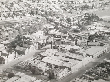
 Eltham District Historical Society Inc
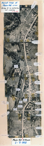
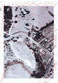
Photograph, Aerial map of Main Road, Eltham from Bridge Street to Wattletree Road, 2 July 1951, 1951
Constructed from five aerial images stitched together and adhered to a coreflute board (approx 100 x 30 cm) with inscriptions of street names and places written and/or stuck onto surface.eltham, main road, aerial photographs, streets, buildings, houses -
Stawell Historical Society Inc
Pamphlet, Aerial photo of North Western Woollen Mills
Framed Hand Coloured Aerial Shot of North Western Woollen Mills c1930 showing Pleasant Creek Hospital and Surgeons Residence in Background. Also Visible is train line and wood heap.industry, health, manufacturing -
 Whitehorse Historical Society Inc.
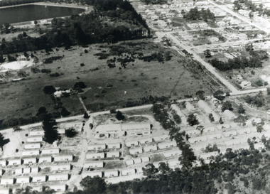
Photograph, Aerial View - Eastbridge Hostel, 1953
Black and white Aerial View of Eastbridge Migrant Hostel in Rooks Road, Nunawading (since demolished) taken in 1953. Donor's Family was first Family in Eastbridge and Donor was Housekeeper there for 2 years.jones, mrs, eastbridge migrant hostel -
 Whitehorse Historical Society Inc.
Photograph - Aerial Photograph, Aerial View of Australian Tesselated Tile Co. Pty. Ltd. & others, 1935
An aerial view of Australian Tessellated Tile Works. |In the background M & MBW reservoir. In the foreground is the Builders Trading and Roofing Company Tile works (formerly the Monarch Pottery - note the M on the chimney)australian tesselated tile co.pty ltd, aerial photographs, dams and reservoirs, mitcham reservoir, builders trading and roofing co. ltd, monarch pottery -
 Cheese World Museum
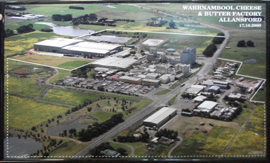
Photograph, Warrnambool Cheese and Butter Factory Co Ltd site 2000 -aerial view, 2000
Warrnambool Cheese and Butter Factory Company was formed by a group of Warrnambool business men. The company was registered in May 1888 and commenced commercial production in November 1888. The company retained its independence for more than 125 years until acquired by Canadian firm Saputo. It has operated from the same site since its inception and also has an office in Japan. Milk processing is undertaken by Sungold. Milk powder for export is also produced on-site. Cheese World is a retail arm of the company operates on a connected site selling company products, local food products, wine and cheese tasting. Cheese World Museum operates under the Cheese World umbrella.Aerial colour photograph of Warrnambool Cheese and Butter Factory in wooden frame. Shows buildings and surrounds. Lines indicate factory boundaries, dotted lines indicate property extension. Date is recorded on the image.17.10.2000allansford, warrnambool cheese and butter factory company, saputo, dairyiing, dairy manufacturing, diary manufacturers, cheese, butter -
 Greensborough Historical Society
Aerial Photograph, Greensborough aerial with property overlay, 1945_
Enlargements of section of 1945 aerial survey photographs of central Greensborough, with property overlay boundaries and some street numbers by Noel WithersTwo photocopied enlargements with property overlay markingsStreet names and some property numbers. Overlays by Noel Withers.greensborough, plenty river -
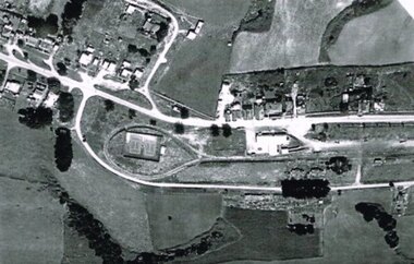
Stawell Historical Society Inc
Photograph, Pleasant Creek Training Centre -- Aerial View
Framed Aerial view of Pleasant Creek Training Centre Referred to as Pleasant Creek Training Centre or Pleasant Creek Special Schoolstawell -
 Stawell Historical Society Inc
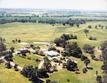
Photograph, "Kirkella" Homestead 2001 -- Aerial Photo
Aerial photograph of Kirkella homestead taken in 2001. Shows Cricket pitch on Right Hand Side of photo partly surrounded by trees.stawell sport -
 Federation University Historical Collection
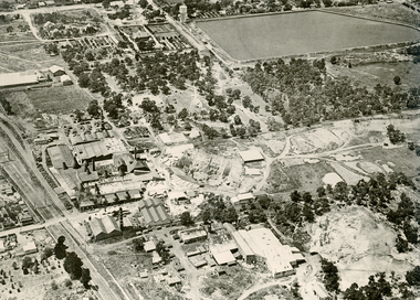
Photograph - Black and White, Aerial Photograph of the Ballarat School of Mines
Aerial Photograph of the Ballarat School of Mines bounded by Armstrong Street South, Grant Street, Albert Street and Dana Street. Buildings depicted include the Ballarat Brewery, Ballarat Gaol, White Flat Ovalballarat school of mines, ballarat brewery, ballarat club, ballarat uniting church, ballarat school of mines model mine, ballarat school of mines mining workshop, ballarat girls' techncial school, albert street, white flat oval, grant street, lydiard sreet, mining laboratory, model mine, armstrong street south, james oddie's bank -
 Whitehorse Historical Society Inc.
Photograph, Aerial View of Mitcham, C.1925
Large Aerial View of Mitcham showing Railway and South side. In particular, The Australian Tesselated Tile Co. Works and Quarry. Also Monarch Works, better known as Builders' Trade and Roofing Co. and their Quarry.australian tesselated tile co. pty ltd, aerial photographs, monarch pottery, builders trading and roofing co. ltd -
 Otway Districts Historical Society
Photograph, R. Preston, Aerial view of Beech Forest railway station and yards, 1965, 13 February 1965
B/W. An aerial view of Beech Forest showing the balloon loop at the end of the station yard (enclosing the two tennis courts), two ex-departmental residences, the station buildings, and other aspects of the township.beech forest: railways; township; aerial; -
 Eltham District Historical Society Inc
Photograph (item) - Aerial Photograph, Aerial Photo: Shire of Eltham War Memorial, Kangaroo Ground, Jan 1951
1951 Aerial photo 1423-110 Run 10 showing the Shire of Eltham War Memorial at centre of image with the newly constructed Caretaker's cottage.aerial photographs, garden hill farm, kangaroo ground, memorial park, shire of eltham war memorial -
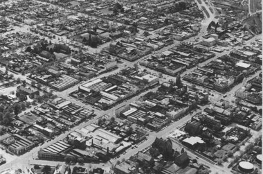 City of Ballarat Libraries
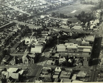
Photograph, Aerial View of the Ballarat CBD in 1957 / 1958
This aerial view of the Ballarat CBC was taken sometime in 1957 or 1958. Sturt Street can be seen running from the right centre to top left.aerial view, sturt street, ballarat, central business district, cbd -
Stawell Historical Society Inc
Photograph, Stawell Aerial View Centred on Town Hall in Main Street 1998 -- Coloured
Colour Aerial View of Stawell 1998 Centred on Town Hall. Main Street. Scallan Street Childe Street Houston Street and Ligar Street.stawell -
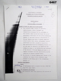 Bendigo Military Museum
Administrative record - Division of National Mapping - Specification for Vertical Aerial Photography, Division of National Mapping, 1963
Commonwealth of Australia, Department of Defence of National Development, Division of National Mapping Specification. This is a Specification for Aerial Photography acquisition and is written for civilian contract work.8 x A4 poor photocopies of typed pagesroyal australian survey corps, rasvy, fortuna, army survey regiment, army svy regt, asr -
 Old Colonists' Association of Ballarat Inc.
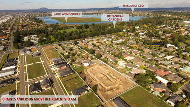
Photograph - Photograph - Colour, Aerial View of Charles Anderson Grove, Ballarat, 2017, 05/2017
Drone footoge featuring the Old Colonists' Association of Ballarat Inc., retirement village at Charles Anderson Grove. The area to the left is being prepared for 18 additional cottages to be built. old colonists' association of ballarat, drone footage, ballarat, aerial, charles anderson grove, retirement village -
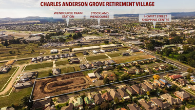
 Old Colonists' Association of Ballarat Inc.
Photograph - Photograph - Colour, Aerial View of Charles Anderson Grove Retirement Village, Ballarat, 2017, 05/2017
Drone footage of Charles Anderson Grove Retirement Village off Gillies Street, Ballarat.charles anderson grove, old colonists' association, ballarat, drone footage, aerial, ballarat, retirement village -
 Stawell Historical Society Inc
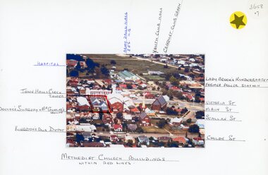
Photograph, Stawell Methodist Church in Main Street Stawell -- Aerial View showing other buildings as well c1980
Stawell Methodist Church. Main Street Stawell. Aerial View. Shows Croquet Green. Kingston's Bus Depot. Doctors Surgery Mr Gunning's House. C1980stawell -
 Stawell Historical Society Inc
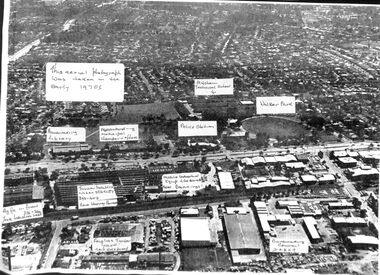
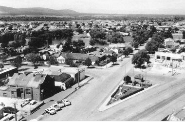
Photograph, Aerial photo of Stawell Lower Main Street looking towards the Grampians 1950's
Aerial shot 1950's, Caltex Service Station, Cato Lake, War Memorial and Weights Bridge, Salvation Army Building and McClure's used Car yard. -
 Federation University Historical Collection
Photograph - Photograph - Black and White, Aerial Photograph of the Ballarat School of Mines and Ballarat East, Pre 1967
Black and white aerial photograph of the Ballarat School of Mines, White Flat Oval, Ballarat Gaol, Ballarat Brewery, Ballarat Club, Uniting Church, John Valves (Lydiard Street), Ballarat Girls' Technical School and Ballarat ballarat gaol, white flat, ballarat uniting church, ballarat girls' technical school, armstrong street south, lydiard street south, yarrowee channel, humffray street south, m.b. john, john valves, former ballarat gaol, ballarat brewery, dana street, grant street, lydiards street south, white flat oval, aerial photograph -
 Eltham District Historical Society Inc
Document - Series Listing, Fraser Faithfull et al, Series 33: Shire Aerial Photograph Collection, 2000
Series consists of 39 aerial photographs and photo maps of the Shire and environs. A separate Item List exists (created on MS Excel spreadsheet), please refer to the attached pagesshire of eltham archives, series listing -
 Phillip Island and District Historical Society Inc.
Photograph, Historic aerial photographs of Phillip Island, Cowes, Rhyll, Cape Woolamai and San Remo, 1930s
Photos taken by an unknown pioneer aviator researched by Kevin O'Reilly who has written a book "Flyers of Time" on pioneer aviation. Photos show the Island and San Remo prior to development and before the bridge was built from the mainland.HistoricalA C D Rom and USB of historic aerial photos about 1930s - 1940s of Phillip Island, Cowes, Rhyll, San Remo and Woolamai. Both formats contain the same 7 photos. Also a letter explaining the history of the photos.photographs, san remo, rhyll, cape woolamai, phillip island bridge, cowes, aerial photograph, digital media, residential development, newhaven -
Ringwood and District Historical Society
Cuttings, Waverley Offset Publishing, Newspaper supplement including information on Ringwood and aerial map of Ringwood Central - c.1960, c.1960
Used to promote Ringwood shopping centre and amenities, with the newspaper promoting a big future.1. Newspaper Supplement - bifold about Ringwood Aerial Map of Ringwood Central - inset photo of Mayor; 2. Two pamphlets bifold. +Additional Keywords: Smart, Gerald (Mayor) / Clarke, B.G. (Mayor) / Gazzard, Clarke (Town Planner)'Ringwood a Big Future' -
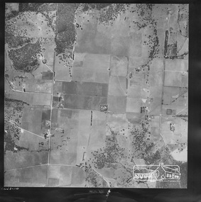
Whitehorse Historical Society Inc.
Map, Aerial Photographs Nunawading, 1970
State Aerial Survey, Melbourne 1970.State Aerial Survey, Melbourne 1970. Project runs 34 - 39 - City of Nunawading. Frames numbered from South to North boundaries, each strip numbered from East to West. See table of index and photo numbers attached.non-fictionState Aerial Survey, Melbourne 1970.state aerial survey, aerial photographs, nunawading, mitcham, blackburn, blackburn north, blackburn south, forest hill, vermont, burwood east, vermont south -
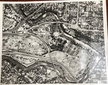 University of Melbourne, Burnley Campus Archives
Photograph - Black and white print, Aerial View of Burnley Campus C.1970, c. 1970
Colour photograph of black and white photograph. Aerial View of Burnley Campus. Enlargement. Shows position of Campus in bend of Yarra River after alterations to the position of the river due to building of Freeway, new ovals and Richmond Public Golf Course.burnley campus, aerial view, yarra river, richmond public golf course -
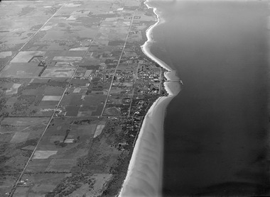
 Lake Bolac & District Historical Society
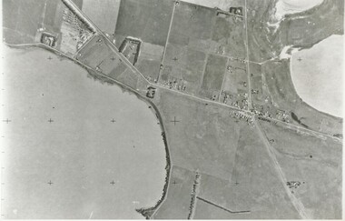
Black and white photograph, Aerial View of Lake Bolac, 1947
Aerial view of Lake Bolac (Boloke) taken in 1947. Fresh water lake at bottom left, salt lakes at top right, village at crossroads of north-south Glenelg highway and Ararat-Mortlake road.lake bolac, 1947, glenelg highway -
Tatura Irrigation & Wartime Camps Museum
Photograph, Aerial View of Tatura
Original coloured aerial photographs taken over Tatura. Landmarks include football and cricket ovals, Lake Bartlett, primary school, swimming pool, tennis courts, caravan park, O'Reilly Road, Hastie Road and Maher Road.Coloured photograph of Tatura from the air.on back: Summer January 1987 from Keith Albrect -
 Phillip Island and District Historical Society Inc.
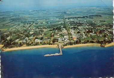
Photograph, 1960 - 1973
One of a Postcard Series.Colour photograph - postcard - aerial view of Cowes"Aerial view of Cowes"local history, newspapers, aerial photograph, cowes, coloured photograph, phillip island, jean jamieson -
 Moorabbin Air Museum
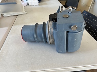
Equipment (item) - Aerial camera F24
The Williamson F24 camera is a camera used for aerial reconnaissance by British and Allied armed forces from 1925 through into the mid-1950s, most particularly during World War II. It is also sometimes referred to as F.24 or F-24.