Showing 556 items matching "bacchus marsh"
-
 Bacchus Marsh & District Historical Society
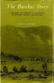
Book, The Bacchus Story: A History of Captain W. H. Bacchus of Bacchus Marsh and His Son, 1973
... Bacchus Marsh and His Son...Bacchus Marsh...Bacchus Marsh & District Historical Society Lerderderg ...William Bacchus was one of the first European colonists to live in the township which was later named after him. He arrived in land occupied by the Wurundjeri and Wadawurrung peoples in 1838 and established a large sheep farm. He died in 1849 and his son Henry Bacchus continued his farming interests in the district until his death in 1887. This work is a biographical portrait of William and Henry Bacchus and of the early European occupation in the Bacchus Marsh district. PUBLICATION DETAILS: Bacchus Marsh, Vic., Bacchus Marsh and District Historical Society Inc., 1973:118 pages, 23 cm.non-fictionWilliam Bacchus was one of the first European colonists to live in the township which was later named after him. He arrived in land occupied by the Wurundjeri and Wadawurrung peoples in 1838 and established a large sheep farm. He died in 1849 and his son Henry Bacchus continued his farming interests in the district until his death in 1887. This work is a biographical portrait of William and Henry Bacchus and of the early European occupation in the Bacchus Marsh district. PUBLICATION DETAILS: Bacchus Marsh, Vic., Bacchus Marsh and District Historical Society Inc., 1973: william bacchus, bacchus family, henry bacchus, bacchus marsh, bmdhs publication -
 Bacchus Marsh & District Historical Society
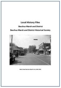
Local History Files Bacchus Marsh and District, 1969- to present
... Local History Files Bacchus Marsh and District...Bacchus Marsh...Bacchus Marsh & District Historical Society Lerderderg ...Local history subject files relating to the township of Bacchus Marsh and its surrounding district. Files may contain replies to research inquiries, photocopies of published and unpublished material from books, newspapers, magazines, pamphlets, maps, archival sources and personal papers.. Other material includes printouts of website pages, and photocopies or printouts of images. Material compiled by members of Bacchus Marsh and District Historical Society.Paper files in ring folders and lever arch folders. Arranged in A-Z sequence of topics.non-fictionLocal history subject files relating to the township of Bacchus Marsh and its surrounding district. Files may contain replies to research inquiries, photocopies of published and unpublished material from books, newspapers, magazines, pamphlets, maps, archival sources and personal papers.. Other material includes printouts of website pages, and photocopies or printouts of images. Material compiled by members of Bacchus Marsh and District Historical Society.local history, bacchus marsh -
 Bacchus Marsh & District Historical Society
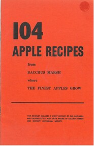
Pamphlet, 104 Apple Recipes from Bacchus Marsh where the Finest Apples Grow
... 104 Apple Recipes from Bacchus Marsh where the Finest...Bacchus Marsh District History...Bacchus Marsh & District Historical Society Lerderderg ...The Bacchus Marsh district has been the location of a major apple orcharding district for well over a century. This pamphlet was produced by the organisers of the Bacchus Marsh Apple Festival as part of a promotional campaign for the Apple Festival and industry in Bacchus Marsh. The pamphlet contains a brief historical outline of apple growing in Bacchus Marsh, and a brief note on the history of the Northcote Childrens Village. The majority of the content is 104 recipes using apples. Most of the recipes were provided by people in the Bacchus Marsh community.Small pamphlet. 32 pages. Stapled. BMDHS Loc: AR/SU5/Pamphlets Box 4non-fictionThe Bacchus Marsh district has been the location of a major apple orcharding district for well over a century. This pamphlet was produced by the organisers of the Bacchus Marsh Apple Festival as part of a promotional campaign for the Apple Festival and industry in Bacchus Marsh. The pamphlet contains a brief historical outline of apple growing in Bacchus Marsh, and a brief note on the history of the Northcote Childrens Village. The majority of the content is 104 recipes using apples. Most of the recipes were provided by people in the Bacchus Marsh community.apples, recipes, cooking, bacchus marsh district history, orchards -
 Bacchus Marsh & District Historical Society
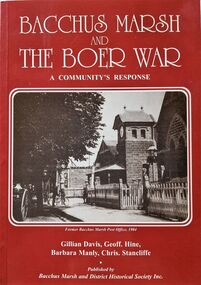
Book, Bacchus Marsh and the Boer War: A Community's Response
... Bacchus Marsh and the Boer War: A Community's Response...Soldiers Bacchus Marsh Vic....Bacchus Marsh & District Historical Society Lerderderg ...An account of the impact of the Boer War upon the community of Bacchus Marsh. Like many communities across Australia Bacchus Marsh saw a number of men enlist in the military forces and participate in the conflict in South Africa between Great Britain and its allies such as Australia against the Boer forces in South Africa in the early 1900s. This work documents this history from the perspective of the individual soldiers involved and the way the community responded to this conflict. Citation: Bacchus Marsh and the Boer War: A Community's Response. By Gillian Davis, Geoff Hine, Barbara Manly and Chris Stancliffe. Published by Bacchus Marsh and District Historical Society, Bacchus Marsh, Vic., 2001.A printed book published in paperback edition. 92 pages, with illustrations, portraits, and maps. BMDHS Location: AR/SU4non-fictionAn account of the impact of the Boer War upon the community of Bacchus Marsh. Like many communities across Australia Bacchus Marsh saw a number of men enlist in the military forces and participate in the conflict in South Africa between Great Britain and its allies such as Australia against the Boer forces in South Africa in the early 1900s. This work documents this history from the perspective of the individual soldiers involved and the way the community responded to this conflict. Citation: Bacchus Marsh and the Boer War: A Community's Response. By Gillian Davis, Geoff Hine, Barbara Manly and Chris Stancliffe. Published by Bacchus Marsh and District Historical Society, Bacchus Marsh, Vic., 2001.bmdhs publication, south african war 1899-1902, boer war 1899-1902, soldiers bacchus marsh vic. -
 Bacchus Marsh & District Historical Society
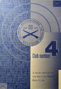
Book, Club Number 4: A Short History of the Bacchus Marsh Rifle Club
... Club Number 4: A Short History of the Bacchus Marsh Rifle...Bacchus Marsh Rifle Club...Bacchus Marsh & District Historical Society Lerderderg ...A brief history of the Bacchus Marsh Rifle Club written to celebrate its 125th anniversary. The club was preceded by an association which formed in 1868 with 14 initial members. It later formed into a club. According to this book rifle shooting is the oldest organised sporting activity in the district of Bacchus Marsh and this work documents this long history up to 1993. The club continues to exist in 2024. Citation: Club Number 4: A Short History of the Bacchus Marsh Rifle Club. Written by John Tidey with additional research by C.D. (Doug) Watson. Published by Bacchus Marsh Rifle Club, Bacchus Marsh, Vic., 1993.A printed book published in paperback edition. 21 pages, with illustrations and portraits. BMDHS Location: AR/SU5 Pamphlets Box 4non-fictionA brief history of the Bacchus Marsh Rifle Club written to celebrate its 125th anniversary. The club was preceded by an association which formed in 1868 with 14 initial members. It later formed into a club. According to this book rifle shooting is the oldest organised sporting activity in the district of Bacchus Marsh and this work documents this long history up to 1993. The club continues to exist in 2024. Citation: Club Number 4: A Short History of the Bacchus Marsh Rifle Club. Written by John Tidey with additional research by C.D. (Doug) Watson. Published by Bacchus Marsh Rifle Club, Bacchus Marsh, Vic., 1993.bacchus marsh rifle club, rifle clubs, shooting -
 Bacchus Marsh & District Historical Society
Building plans and designs for various hotels in the Bacchus Marsh region c.1930s-2000s
... Bacchus Marsh region c.1930s-2000s...Hotels Bacchus Marsh Region... and Wallace. Hotels Bacchus Marsh Region Hotels Designs and Plans ...Plans in this collection include hotels and premises licensed to sell liquor in Ballan, Lal Lal, Myrniong, Spargo Creek and Wallace.Architecture plans and drawings on single sheets of paper mostly ranging in size from A3 to A2. BMDHS Location: AR/R5/S2hotels bacchus marsh region, hotels designs and plans, hotels architectural plans, hotels building plans -
 Bacchus Marsh & District Historical Society
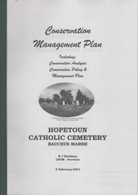
Booklet, Conservation Management Plan Hopetoun Cemetery Bacchus Marsh
... Conservation Management Plan Hopetoun Cemetery Bacchus...Cemeteries Bacchus Marsh...Hopetoun Catholic Cemetery Cemeteries Bacchus Marsh ...The Hopetoun Cemetery is located just a few kilometers east of Bacchus Marsh and is adjacent to the Western Freeway between Melton and Bacchus Marsh. This small cemetery is one of the oldest Catholic cemeteries in Victoria outside of Melbourne and has significant heritage significance. This conservation management plan was produced in 2001 by a team of professional heritage consultants with the support of the Hopetoun Catholic Cemetery Preservation Group. The report contains a site conservation analysis and a plan for the ongoing preservation and and management of the site.Printed foolscap booklet. 75 pages of text. 4 pages of maps, including 2 foldout maps. Appendices 8 pages. 210mm x 300mmThe Hopetoun Cemetery is located just a few kilometers east of Bacchus Marsh and is adjacent to the Western Freeway between Melton and Bacchus Marsh. This small cemetery is one of the oldest Catholic cemeteries in Victoria outside of Melbourne and has significant heritage significance. This conservation management plan was produced in 2001 by a team of professional heritage consultants with the support of the Hopetoun Catholic Cemetery Preservation Group. The report contains a site conservation analysis and a plan for the ongoing preservation and and management of the site.hopetoun catholic cemetery, cemeteries bacchus marsh -
 Bacchus Marsh & District Historical Society
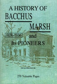
Book, A History of Bacchus Marsh and its pioneers, 1836-1936
... A History of Bacchus Marsh and its pioneers, 1836-1936...Bacchus Marsh Vic. History...Bacchus Marsh Vic. History Pioneers Biographies BMHDS ...Historical and biographical articles relating to the town and district of Bacchus Marsh. First published in regular installments in the Bacchus Marsh Express newspaper during the years 1913 - 1917. Written by William Williams, headmaster of Bacchus Marsh State School. The articles were later published in book form in 1936 by Crisp and Sons, owners and publishers of the Bacchus Marsh Express. The publication also includes separate articles, 'Recollections' by Charles Hegarty; 'Bacchus Family History'; and 'Some Early History of Mount Blackwood' by Robert Lidgett. This edition was reproduced as a facsimile edition by Bacchus Marsh and District Historical Society in 2015. Printed by FRP Printing Pty Ltd.269 pages; 21 cm. With names and events index.non-fictionHistorical and biographical articles relating to the town and district of Bacchus Marsh. First published in regular installments in the Bacchus Marsh Express newspaper during the years 1913 - 1917. Written by William Williams, headmaster of Bacchus Marsh State School. The articles were later published in book form in 1936 by Crisp and Sons, owners and publishers of the Bacchus Marsh Express. The publication also includes separate articles, 'Recollections' by Charles Hegarty; 'Bacchus Family History'; and 'Some Early History of Mount Blackwood' by Robert Lidgett. This edition was reproduced as a facsimile edition by Bacchus Marsh and District Historical Society in 2015. Printed by FRP Printing Pty Ltd.bacchus marsh vic. history, pioneers biographies, bmhds reprints -
 Bacchus Marsh & District Historical Society
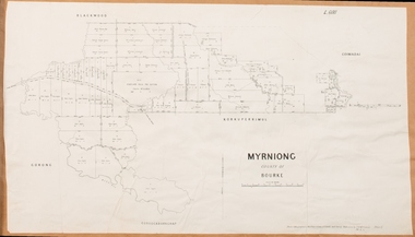
Map, Myrniong Parish Map 1904
... Bacchus Marsh Region Parish Plans...Shire of Bacchus Marsh...Myrniong Parish Plan Myrniong Parish Maps Bacchus Marsh ...A single page paper map showing the map for the Parish of Myrniong in the County of Bourke. A cadastral map showing parish boundaries and land ownership. The map is pasted into a bound volume containing 76 maps or plans in total. High resolution digital image stored on BMDHS computer network. myrniong parish plan, myrniong parish maps, bacchus marsh region parish plans -
 Bacchus Marsh & District Historical Society
Map, Parwan Parish Map, County of Grant, 1909
... Bacchus Marsh Region Parish Plans...Shire of Bacchus Marsh...Bacchus Marsh Region Parish Plans Parwan Parish Maps Parwan ...A single page paper map showing the map for the Parish of Parwan in the County of Grant. A cadastral map showing parish boundaries and land ownership. The map is pasted into a bound volume containing 76 maps or plans in total. High resolution digital image stored on BMDHS computer network. Photo-lithographed at the Department of Lands and Survey, Melbourne by T.F. McGauran, 7.7.09. bacchus marsh region parish plans, parwan parish maps, parwan parish plan -
 Bacchus Marsh & District Historical Society
Map, Trentham Parish Map 1905 Copy 1
... Bacchus Marsh Region Parish Plans...Shire of Bacchus Marsh...Trentham Parish Maps Trentham Parish Plan Bacchus Marsh ...A single page paper map showing the map for the Parish of Trentham in the Counties of Dalhousie and Bourke. A cadastral map showing parish boundaries and land ownership. The map is pasted into a bound volume containing 76 maps or plans in total. High resolution digital image stored on BMDHS computer network. Photo-lithographed at the Department of Lands and Survey, Melbourne by T.F. McGauran 22.3.05 trentham parish maps, trentham parish plan, bacchus marsh region parish plans -
 Bacchus Marsh & District Historical Society
Map, Blackwood Parish Map, County of Bourke, 1892
... Bacchus Marsh Region Parish Plans...Shire of Bacchus Marsh...Bacchus Marsh Region Parish Plans Blackwood Parish Plan ...A single page paper map showing the map for the Parish of Blackwood in the County of Bourke. A cadastral map showing parish boundaries and land ownership. The map is pasted into a bound volume containing 76 maps or plans in total. High resolution digital image stored on BMDHS computer network. Photo-lithographed at the Department of Lands and Survey, Melbourne by T.F. McGauran 14.7.92bacchus marsh region parish plans, blackwood parish plan, blackwood parish maps -
 Bacchus Marsh & District Historical Society
Map, Blackwood Parish Map, County of Bourke, 1905
... Bacchus Marsh Region Parish Plans...Shire of Bacchus Marsh...Bacchus Marsh Region Parish Plans Blackwood Parish Plan ...A single page paper map showing the map for the Parish of Blackwood in the County of Bourke. A cadastral map showing parish boundaries and land ownership. The map is pasted into a bound volume containing 76 maps or plans in total. High resolution digital image stored on BMDHS computer network. Photo-lithographed at the Department of Lands and Survey, Melbourne by T.F. McGauran 21.7.05bacchus marsh region parish plans, blackwood parish plan, blackwood parish maps -
![Map, Late the Property of Robert Lawson Esq. [Landsberg Estate Blackwood]](/media/collectors/5e461d8021ea67224c82f2a1/items/67763722eb6d2cbd24dff14f/item-media/677637b7eb6d2cbd24dff29d/item-fit-380x285.jpg) Bacchus Marsh & District Historical Society
Bacchus Marsh & District Historical SocietyMap, Late the Property of Robert Lawson Esq. [Landsberg Estate Blackwood]
... Bacchus Marsh Victoria Maps...Shire of Bacchus Marsh... and was possibly produced at the same time. Bacchus Marsh Victoria Maps ...The date this map was created has not been identified. It was possibly created at the time the Landsberg Estate near Blackwood was subdivided and sold into smaller lots in December 1886. This land once belonged to Robert Lawson who died in 1869. Lawson was a well known school teacher who founded Scotch College in Melbourne before setting up a school near Blackwood. This map is similar to another map in the BMDHS collection titled 'Landsberg Estate Blackwood' Victorian Collections record 459 and was possibly produced at the same time.Single page map showing land allotments which made up the Landsberg Estate near Blackwood. Scale 20 chains to 1 inch. The map is pasted into a bound volume containing 76 maps or plans in total. High resolution digital image stored on BMDHS computer network. At the top of the map: 'Late the Property of Robert Lawson Esq.'bacchus marsh victoria maps, landsberg estate blackwood -
 Bacchus Marsh & District Historical Society
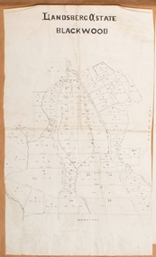
Map, Landsberg Estate Blackwood
... Bacchus Marsh Victoria Maps...Shire of Bacchus Marsh... was subdivided and sold into smaller lots in December 1886. Bacchus Marsh ...The date this map was created has not been identified. It was possibly created at the time the Landsberg Estate near Blackwood was subdivided and sold into smaller lots in December 1886.Single page map showing land allotments which made up the Landsberg Estate near Blackwood. Scale 20 chains to 1 inch. The map is pasted into a bound volume containing 76 maps or plans in total. High resolution digital image stored on BMDHS computer network. bacchus marsh victoria maps, landsberg estate blackwood -
 Bacchus Marsh & District Historical Society
Map, Myrniong Parish Map, County of Bourke, 1882
... Bacchus Marsh Region Parish Plans...Shire of Bacchus Marsh...Myrniong Parish Plan Myrniong Parish Maps Bacchus Marsh ...A single page paper map showing the map for the Parish of Myrniong in the County of Bourke. A cadastral map showing parish boundaries and land ownership. The map is pasted into a bound volume containing 76 maps or plans in total. High resolution digital image stored on BMDHS computer network. Photo-lithographed at the Department of Lands and Survey, Melbourne by J. Noone, 17.7.82myrniong parish plan, myrniong parish maps, bacchus marsh region parish plans -
 Bacchus Marsh & District Historical Society
Map, Limestone Reserve Parish of Merrimu 1888
... Bacchus Marsh Victoria Maps...Shire of Bacchus Marsh... industry over several generations at Coimadai. Bacchus Marsh ...Limestone deposits in the Coimadai area 10 kilometers north of Ballarat were first worked in the 1850s. The area was quarried for limestone for many years by various people and companies. The surveyor's name who produced this plan is inscribed on the map and below this is the name P. L. Alkemade, who presumably paid for the map to be produced. In 1886 Petrus Alkemade in partnership with Matthew Egan established the Alkemade Hydraulic Lime and Cement Company. The Alkemade family were involved in the limestone industry over several generations at Coimadai.Single page map showing part of the Limestone reserve near Coimadai in the Parish of Merrimu. Scale 4 chains to 1 inch. Part of a set of maps which are pasted into a bound volume containing 76 maps or plans in total. High resolution digital image stored on BMDHS computer network. Copy of plan surveyed by Mr. G? [illegible] an authorised surveyor on 17th July 1888. P. L. Alkemadebacchus marsh victoria maps, lime kilns coimadai, limestone, coimadai victoria maps, alkemade family coimadai -
 Bacchus Marsh & District Historical Society
Map, Mooradoranook Parish Map, County of Grant
... Bacchus Marsh Region Parish Plans...Shire of Bacchus Marsh.... Mooradoranook Parish Map, County of Grant Map Shire of Bacchus Marsh ...A single page paper map showing the map for the Parish of Mooradanook in the County of Grant. Cadastral map showing land ownership. The map is pasted into a bound volume containing 76 maps or plans in total. High resolution digital image stored on BMDHS computer network. Photo lithographed at the Department of Lands and Survey Melbourne by T. F. McGauran, 27.11.06mooradoranook parish maps, mooradoranook parish plan, bacchus marsh region parish plans -
 Bacchus Marsh & District Historical Society
Map, Mouyong Parish Map, County of Grant
... Bacchus Marsh Region Parish Plans...Shire of Bacchus Marsh...Mouyong Parish Plan Mouyong Parish Maps Bacchus Marsh ...A single page paper map showing the map for the Parish of Mouyong in the County of Grant. Cadastral map showing land ownership. The map is pasted into a bound volume containing 76 maps or plans in total. High resolution digital image stored on BMDHS computer network. Photo lithographed at the Department of Lands and Survey Melbourne by T. F. McGauran, 9. 4. 07mouyong parish plan, mouyong parish maps, bacchus marsh region parish plans -
 Greensborough Historical Society
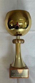
Award - Trophy, Thomastown Golf Club, Thomastown Golf Club. B Grade winner, R. Jones, Bacchus Marsh, 05/12/1982, 1982
... Thomastown Golf Club. B Grade winner, R. Jones, Bacchus..."Thomastown Golf Club. B Grade winner, R. Jones, Bacchus..., Bacchus Marsh, 05/12/1982." engraved on plaque. Golf trophy ...Golf trophy awarded by the Thomastown Golf Club. Bob Jones was a foundation member of the Club and Secretary for many years.Thomastown Golf Club was a social club formed in 1976. This is part of the Robert (Bob) Jones collection of Club memorabilia.Golf trophy, plastic and timber. "Thomastown Golf Club. B Grade winner, R. Jones, Bacchus Marsh, 05/12/1982." engraved on plaque.thomastown golf club, golf trophies, bob jones, robert jones -
 Ballarat Heritage Services
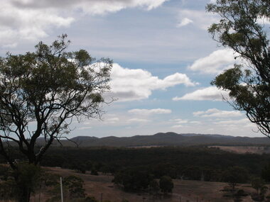
Photograph - Photograph - Colour, Coimodai near Bacchus Marsh, 2007, 04/03/2007
... Coimodai near Bacchus Marsh, 2007...Coimodai is in the vicinity of Bacchus Marsh, Victoria... Office goldfields Coimodai is in the vicinity of Bacchus Marsh ...Coimodai is in the vicinity of Bacchus Marsh, VictoriaA number of photos taken to create a 360 degree view of Coimadaicoimodai, farmland, landscape -
 Greensborough Historical Society
Award - Trophy, Thomastown Golf Club, Thomastown Golf Club. First player to reach 300 games: Bob Jones, Bacchus Marsh, 04/11/1990, 1990
... Jones, Bacchus Marsh, 04/11/1990. ... Jones, Bacchus Marsh, 04/11/1990. " engraved on plaque...., Bacchus Marsh, 04/11/1990. " engraved on plaque. Golf trophy ...Golf trophy awarded by the Thomastown Golf Club. Bob Jones was a foundation member of the Club and Secretary for many years.Thomastown Golf Club was a social club formed in 1976. This is part of the Robert (Bob) Jones collection of Club memorabilia.Golf trophy, large metal cup on timber base."Thomastown Golf Club. First player to reach 300 games: Bob Jones, Bacchus Marsh, 04/11/1990. " engraved on plaque.thomastown golf club, golf trophies, bob jones -
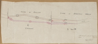 Bacchus Marsh & District Historical Society
Map, Road plan deviation near Glenmore
... Glenmore. This is likely to have been the Bacchus Marsh to Ballan...Shire of Bacchus Marsh... Glenmore. This is likely to have been the Bacchus Marsh to Ballan ...This plan shows a proposed deviation in the road near Glenmore. This is likely to have been the Bacchus Marsh to Ballan road. The precise date of the plan has not been established. Proposed deviations to the road near Glenmore appear in reports in the Bacchus Marsh Express newspaper through many decades, especially in the 1870s and 1880s. Glenmore is located 19 kilometers west of Bacchus Marsh.A single page paper map showing a plan for a road deviation near Glenmore Station. Scale 5 chains to 1 inch. Date of production unknown. Circa 1860s-1890s. The map is pasted into a bound volume containing 76 maps or plans in total. High resolution digital image stored on BMDHS computer network. Old road colored Yellow, New road colored Pinkroad plans, road construction, glenmore victoria maps -
 Bacchus Marsh & District Historical Society
Map, Bullengarook Parish, County of Bourke
... . This parish area is close to the Bacchus Marsh district and borders...Shire of Bacchus Marsh.... This parish area is close to the Bacchus Marsh district and borders ...An undated parish plan map for the parish of Bullegarook. This parish area is close to the Bacchus Marsh district and borders some of the areas contained within the former Bacchus Marsh Shire and present day Moorabool Shire.A single page paper map showing the parish plan map for Bullengarook. This parish area contains the locality of Bullengarook and parts of the Wombat State Forest and is close to the town of Gisborne. A cadastral map showing land ownership. The map is not dated but a very similar map held by the State Library of Victoria is estimated to date from about 1927. The map is pasted into a bound volume containing 76 maps or plans in total. High resolution digital image stored on BMDHS computer network. bullengarook parish maps -
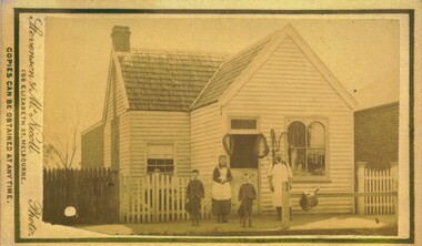 Bacchus Marsh & District Historical Society
Photograph, Thomas Heath's Saddlery Main Street Bacchus Marsh 1883 Image 1
... Thomas Heath's Saddlery Main Street Bacchus Marsh 1883... in Bacchus Marsh he retired and the assets of his business were sold... framing photograph. Housed in the album, 'Photographs of Bacchus... in Bacchus Marsh he retired and the assets of his business were sold ...Thomas Heath built this shop for his saddlery business around 1875. In 1926 after 58 years operating his saddlery in Bacchus Marsh he retired and the assets of his business were sold in a clearing sale. The building was located close to the current day location of 192 Main Street and has been demolished. Apart from his services in saddlery his premises was known to be a gathering place for much discussion. Heath was known to openly express his political opinions and his saddlery premises was known by many in the community as the 'Parliament'.Small sepia unframed photograph on card with gold border framing photograph. Housed in the album, 'Photographs of Bacchus Marsh and District in 1883 by Stevenson and McNicoll'. The photo is of a double-fronted weatherboard building with a shingle roof. The front gabled section stands directly on street level and is flanked by a picket fence. The door and overhead window and the side window with arched panels may indicate that this was the shop section, with a dwelling to the rear. Items which may be for sale can be seen hanging in the windows. The recessed side section of the building with a twelve-sectioned window, chimney and a back extension was probably the dwelling used by the family. On the footpath stands the saddler with three children, two boys and an older girl, probably Mr Thomas Heath and three of his five children. A hitching rail runs along the front of the workshop. Indicating the type of business Mr Heath ran, are a saddle placed over the rail and two horse collars and reins hanging either side of the workshop door. On the front: Stevenson & McNicoll. Photo. 108 Elizabeth St. Melbourne. COPIES CAN BE OBTAINED AT ANY TIME. On the back: LIGHT & TRUTH inscribed on a banner surmounted by a representation of the rising sun. Copies of this Portrait can be had at any time by sending the Name and Post Office Money Order or Stamps for the amount of order to STEVENSON & McNICOLL LATE BENSON & STEVENSON, Photographers. 108 Elizabeth Street, MELBOURNE. saddleries, saddlers, thomas heath 1842-1930 saddler -
![Map, [Plan for road to give J. Allan access to permanent water at Coimadai] circa 1870s](/media/collectors/5e461d8021ea67224c82f2a1/items/67735190d671e67dd573a84c/item-media/6773533dd671e67dd573cd90/item-fit-380x285.jpg) Bacchus Marsh & District Historical Society
Bacchus Marsh & District Historical SocietyMap, [Plan for road to give J. Allan access to permanent water at Coimadai] circa 1870s
... , 1874 (see Bacchus Marsh Express, 11 July, 1874, page. 3...Shire of Bacchus Marsh..., 1874 (see Bacchus Marsh Express, 11 July, 1874, page. 3 ...The date of this map or plan is uncertain but it appears to be from the early to mid 1870s. One of the landholders identified on the plan, James Allan of Coimadai died suddenly on the 9th July, 1874 (see Bacchus Marsh Express, 11 July, 1874, page. 3). There are mentions of an Allans Road at Coimadai in the Bacchus Marsh Express between 1887 and 1942.Single page map showing an excision of land belonging to Charles Ross which was selected to construct a road to give another landholder, J. Allan access to permanent water. Scale 1 chain to 1 inch. Part of a set of maps which are pasted into a bound volume containing 76 maps or plans in total. High resolution digital image stored on BMDHS computer network. Plan showing Excisions from Ross's selection and 1 chain road thro' the said selection in Coimadai to give J. Allan access to permanent water. Alistair ?? Shire Eng? 6?/5/7?coimadai victoria maps, coimadai roads and streets -
 Bacchus Marsh & District Historical Society
Map, Gorrockburkchap Parish Map, County of Grant c.1915
... of Bacchus Marsh. The locality of Rowsley is situated within...Shire of Bacchus Marsh... of Bacchus Marsh. The locality of Rowsley is situated within ...The parish of Gorrockburkchap (sometimes spelled Gorrockburkghap) lies to the west and south west of the township of Bacchus Marsh. The locality of Rowsley is situated within this parish area.A single page paper map showing the parish plan for Gorrockburkchap in the County of Grant. The map is pasted into a bound volume containing 76 maps or plans in total. High resolution digital image stored on BMDHS computer network. gorrockburkchap parish maps, rowsley victoria maps -
 Bacchus Marsh & District Historical Society
Map, Gorrockburkchap Parish Map, County of Grant
... of Bacchus Marsh. The locality of Rowsley is situated within...Shire of Bacchus Marsh... of Bacchus Marsh. The locality of Rowsley is situated within ...The parish of Gorrockburkchap (sometimes spelled Gorrockburkghap) lies to the west and south west of the township of Bacchus Marsh. The locality of Rowsley is situated within this parish area.A single page paper map showing the parish plan for Gorrockburkchap in the County of Grant. The map is pasted into a bound volume containing 76 maps or plans in total. High resolution digital image stored on BMDHS computer network. gorrockburkchap parish maps, rowsley victoria maps -
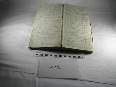 Blacksmith's Cottage and Forge
Book, Day, Day Book, 20 January 1920 to 27 April 1921
... On the inner cover - Mrs C Edwards, Main Street, Bacchus...Bacchus Marsh, Australia... in the Bacchus Marsh district and the work performed for them ...This book contains information relating to daily work conducted by Charles Edwards, Blacksmith, during period 20th January 1920 to 27 April 1921. It lists customer names, types of work done and costs involved. The written X indicates whether work was paid in full.This books contains historical information relating to peoples names and industries in the Bacchus Marsh district and the work performed for them by the blacksmith during the period mentioned. Most of work relates to shoeing horses, repairs to horse drawn vehicles, repairs to farm machinery/tools and some work on cars.Cardboard covers - green marbled design with black spine. Account type book with red ruled columns. Hand written names, jobs, charges and dates.On the inner cover - Mrs C Edwards, Main Street, Bacchus Marshbook, blacksmith, day, customers, clients, charles edwards