Showing 264 items
matching bakery site
-
 Ballarat Heritage Services
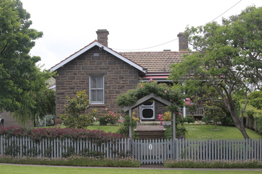
Digital photograph, Lisa Gervasoni, Bluestone House, Portland, 2016, 30/12/2016
Photograph of a bluestone house near the site of the former Immigration Depot.portland, heritage, bay, water, beach, bridgewater -
 Ballarat Heritage Services
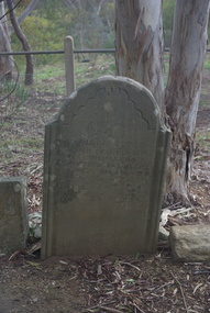
Photograph - Colour, Vaughan Chinese Cemetery, 2017, 16/07/2017
This site was used as a burial ground from 1855 (about) to 1859. European and Chinese pioneers rest here. The Bendigo Chinese Society Honouring the memory of their Countrymen, fenced the site, 1928. Population of Vaughan 1859, 13000vaughan, vaughan springs, vaughan chinese cemetery, chinese -
 Ballarat Heritage Services
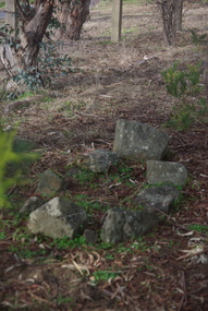
Photograph - Colour, Grave at Vaughan Chinese Cemetery, 2017, 16/07/2017
This site was used as a burial ground from 1855 (about) to 1859. European and Chinese pioneers rest here. The Bendigo Chinese Society Honouring the memory of their Countrymen, fenced the site, 1928 Population of Vaughan 1859, 13000vaughan, vaughan springs, vaughan chinese cemetery, chinese -
 Ballarat Heritage Services
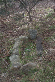
Photograph - Colour, Grave at Vaughan Chinese Cemetery, 2017, 16/07/2017
This site was used as a burial ground from 1855 (about) to 1859. European and Chinese pioneers rest here. The Bendigo Chinese Society Honouring the memory of their Countrymen, fenced the site, 1928 Population of Vaughan 1859, 13000vaughan, vaughan springs, vaughan chinese cemetery, chinese -
 Ballarat Heritage Services
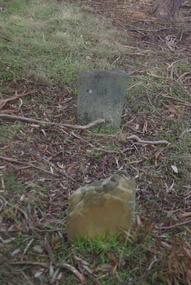
Photograph - Colour, Grave at Vaughan Chinese Cemetery, 2017, 16/07/2017
This site was used as a burial ground from 1855 (about) to 1859. European and Chinese pioneers rest here. The Bendigo Chinese Society Honouring the memory of their Countrymen, fenced the site, 1928 Population of Vaughan 1859, 13000vaughan, vaughan springs, vaughan chinese cemetery, chinese -
 Ballarat Heritage Services
Photograph - Colour, Grave at Vaughan Chinese Cemetery, 2017, 16/07/2017
This site was used as a burial ground from 1855 (about) to 1859. European and Chinese pioneers rest here. The Bendigo Chinese Society Honouring the memory of their Countrymen, fenced the site, 1928 Population of Vaughan 1859, 13000vaughan, vaughan springs, vaughan chinese cemetery, chinese, thomas eynon -
 Ballarat Heritage Services
Pamphlet - Photograph - Colour, Grave at Vaughan Chinese Cemetery, 2017, 16/07/2017
This site was used as a burial ground from 1855 (about) to 1859. European and Chinese pioneers rest here. The Bendigo Chinese Society Honouring the memory of their Countrymen, fenced the site, 1928 Population of Vaughan 1859, 13000vaughan, vaughan springs, vaughan chinese cemetery, chinese, thomas eynon -
 Ballarat Heritage Services
Photograph - Colour, Grave at Vaughan Chinese Cemetery, 2017, 16/07/2017
This site was used as a burial ground from 1855 (about) to 1859. European and Chinese pioneers rest here. The Bendigo Chinese Society Honouring the memory of their Countrymen, fenced the site, 1928 Population of Vaughan 1859, 13000vaughan, vaughan springs, vaughan chinese cemetery, chinese, thomas eynon -
 Ballarat Heritage Services
Photograph - Colour, House Near Vaughan Chinese Cemetery, 2017, 16/07/2017
This site was used as a burial ground from 1855 (about) to 1859. European and Chinese pioneers rest here. The Bendigo Chinese Society Honouring the memory of their Countrymen, fenced the site, 1928 Population of Vaughan 1859, 13000vaughan, vaughan springs, vaughan chinese cemetery, chinese, thomas eynon -
 Ballarat Heritage Services
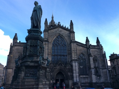
Digital Photograph, St Giles Cathedral, Edinburgh, Scotland, 10/2016
St Giles, also known as the High Kirk of Edinburgh is the principal place of worship for the Church of Scotland. It is very interesting for the mason's marks found on its many stone columns inside the church, and for its connections to the graveyard outside. According to wikipedia, "There is record evidence of a church here, very likely on the present site, in the year 854. In 1120 King Alexander I, rebuilt the church in the Norman style. Of this building characteristic features survived until 1798. During the fourteenth century, Edinburgh was captured and plundered by the English under Edward II. and Edward III., and twice St Giles was laid waste. After restoration, the church was more thoroughly ruined at the Burnt Candlemas in 1387, when Richard II. sacked the city. The western part of the fabric was soon in use again ; but the restoration of the choir and transepts, which were much enlarged, lasted on into the sixteenth century. In 1467 the city endowed St Giles as a collegiate church. It now became usual to speak of the nave, where the stonework was ancient, as the Old Kirk, while the eastern part of the building was called the New Kirk. When the movement for reform drew large crowds to St Giles, separate services began to be regularly held in the Old and New Kirks. Soon this was not enough, and the great church was partitioned off into smaller sections. In 1571 St Giles was seized by Kirkcaldie of Grange, and held by him as a stronghold for Queen Mary. This resulted in serious damage to the structure.Colour photograph of St Giles Cathedral, Edinburgh, Scotlandst giles cathedral, edinburgh, scotland, architecture -
 Ballarat Heritage Services
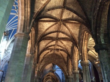
Digital Photograph, Dorothy Wickham, Interior, St Giles Cathedral, Edinburgh, Scotland, 10/2016
St Giles, also known as the High Kirk of Edinburgh is the principal place of worship for the Church of Scotland. It is very interesting for the mason's marks found on its many stone columns inside the church, and for its connections to the graveyard outside. According to wikipedia, "There is record evidence of a church here, very likely on the present site, in the year 854. In 1120 King Alexander I, rebuilt the church in the Norman style. Of this building characteristic features survived until 1798. During the fourteenth century, Edinburgh was captured and plundered by the English under Edward II. and Edward III., and twice St Giles was laid waste. After restoration, the church was more thoroughly ruined at the Burnt Candlemas in 1387, when Richard II. sacked the city. The western part of the fabric was soon in use again ; but the restoration of the choir and transepts, which were much enlarged, lasted on into the sixteenth century. In 1467 the city endowed St Giles as a collegiate church. It now became usual to speak of the nave, where the stonework was ancient, as the Old Kirk, while the eastern part of the building was called the New Kirk. When the movement for reform drew large crowds to St Giles, separate services began to be regularly held in the Old and New Kirks. Soon this was not enough, and the great church was partitioned off into smaller sections. In 1571 St Giles was seized by Kirkcaldie of Grange, and held by him as a stronghold for Queen Mary. This resulted in serious damage to the structure.Two colour photographs of the interior if St Giles Cathedral, Edinburgh, Scotlandst giles cathedral, architecture, mason's marks, stonemasons, church of scotland -
 Ballarat Heritage Services
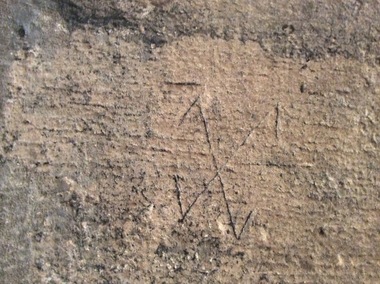
Digital Photograph, Stonemason's marks, St Giles Cathedral, Edinburgh, Scotland, 10/2016
St Giles, also known as the High Kirk of Edinburgh is the principal place of worship for the Church of Scotland. It is very interesting for the mason's marks found on its many stone columns inside the church, and for its connections to the graveyard outside. According to wikipedia, "There is record evidence of a church here, very likely on the present site, in the year 854. In 1120 King Alexander I, rebuilt the church in the Norman style. Of this building characteristic features survived until 1798. During the fourteenth century, Edinburgh was captured and plundered by the English under Edward II. and Edward III., and twice St Giles was laid waste. After restoration, the church was more thoroughly ruined at the Burnt Candlemas in 1387, when Richard II. sacked the city. The western part of the fabric was soon in use again ; but the restoration of the choir and transepts, which were much enlarged, lasted on into the sixteenth century. In 1467 the city endowed St Giles as a collegiate church. It now became usual to speak of the nave, where the stonework was ancient, as the Old Kirk, while the eastern part of the building was called the New Kirk. When the movement for reform drew large crowds to St Giles, separate services began to be regularly held in the Old and New Kirks. Soon this was not enough, and the great church was partitioned off into smaller sections. In 1571 St Giles was seized by Kirkcaldie of Grange, and held by him as a stronghold for Queen Mary. This resulted in serious damage to the structure.Colour photographs of tonemason's marks, St Giles Cathedral, Edinburgh, Scotlandmason's marks, st giles cathedral -
 Ballarat Heritage Services
Photograph - Digital Photograph, Stonemason's marks, St Giles Cathedral, Edinburgh, Scotland, 10/2016
St Giles, also known as the High Kirk of Edinburgh is the principal place of worship for the Church of Scotland. It is very interesting for the mason's marks found on its many stone columns inside the church, and for its connections to the graveyard outside. According to wikipedia, "There is record evidence of a church here, very likely on the present site, in the year 854. In 1120 King Alexander I, rebuilt the church in the Norman style. Of this building characteristic features survived until 1798. During the fourteenth century, Edinburgh was captured and plundered by the English under Edward II. and Edward III., and twice St Giles was laid waste. After restoration, the church was more thoroughly ruined at the Burnt Candlemas in 1387, when Richard II. sacked the city. The western part of the fabric was soon in use again ; but the restoration of the choir and transepts, which were much enlarged, lasted on into the sixteenth century. In 1467 the city endowed St Giles as a collegiate church. It now became usual to speak of the nave, where the stonework was ancient, as the Old Kirk, while the eastern part of the building was called the New Kirk. When the movement for reform drew large crowds to St Giles, separate services began to be regularly held in the Old and New Kirks. Soon this was not enough, and the great church was partitioned off into smaller sections. In 1571 St Giles was seized by Kirkcaldie of Grange, and held by him as a stronghold for Queen Mary. This resulted in serious damage to the structure.Three photographs of stonemason's marks, St Giles Cathedral, Edinburgh, Scotlandmason's marks, st giles cathedral -
 Ballarat Heritage Services
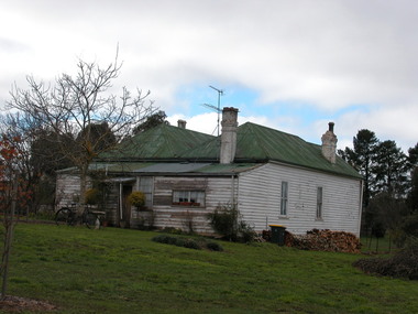
Photograph - Photographs - Colour, Stanbridge House in Frazer Street, Daylesford, 15/06/2004
William Stanbridge was a squatter who built Wombat Estate. Photograph of a weatherboard house. This is a former Stanbridge house which was moved to the site. william stanbridge, weatherboard, frazer street, daylesford -
 Ballarat Heritage Services
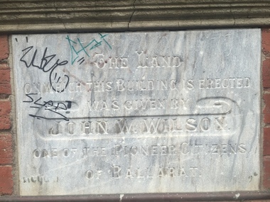
Photograph - Photograph - Colour, Clare Gervasoni, YMCA Ballalrat, 2016, 30/07/2016
At one time pre-service teachers' of the Ballarat Teachers' College boarded at the YMCA. There also used to be an inside pool at the site. Three photographs relating to the YMCA Ballarat building, including the Foundation stone. The land on which this building is erected was given by John W. Wilson one of the pioneer citizens of Ballaratymca, young mens christian association, foundation stone, camp street, ballarat, john w. wilson -
 Ballarat Heritage Services
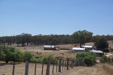
Photograph - Photograph - Colour, Former Lake Condah Aboriginal Mission, 17/04/2016
The Lake Condah Mission site includes bluestone ruins and a reconstructed timber building, as well as the cemetery which were part of the original settlement. With European settlement in the 1830s came conflict. Gunditjmara people fought for their land during the Eumerella wars, which lasted more than 20 years. As this conflict drew to an end in the 1860s, many Aboriginal people were displaced and the Victorian government began to develop reserves to house them. Many Aboriginal people refused to move from their ancestral land and eventually the government agreed to build a mission at Lake Condah, close to some of the eel traps and within sight of Budj Bim (Mt Eccles). The mission opened in 1867. The Mission was formally closed in 1918, and Aboriginal people were forced off the Mission, some moving to Lake Tyers. The Gunditjmara protested against the Mission’s closure and many continued to reside in the buildings until the majority of the reserve land was handed over to the Soldier Settlement Scheme in the 1940s. The mission was destroyed by the government in the 1950s in an effort to force the integration of Gunditjmara people with the general community but the Gunditjmara people continued to live in the area and protect their heritage. The mission lands were returned to the Gunditjmara in 1987. Lake Condah Mission is a place with special meaning to the Gunditjmara community - as a community meeting place, an administrative centre, a symbol of political struggle and a link to family histories. As a result the Gunditjmara community do not want open public access to this site. Key Features of Interest Ruins of stone cottages and plot remains of buildings such as the church Reconstructed dormitory building (https://www.budjbim.com.au/visit/cultural-sites/lake-condah-mission/?gclid=EAIaIQobChMIz6j36ZvF-QIV8ZhmAh2tmA3qEAAYASAAEgLxrvD_BwE, accessed 2022)Colour photographs of the former Lake Condah Aboriginal Missionlake condah, lake condah aboriginal mission, aborigines, aboriginal, gunditjmara, eumerella wars -
 Ballarat Heritage Services
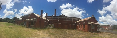
Photograph - Colour, Clare Gervasoni, Glenormiston Butter & Cheese Factory Company, 2015, 26/12/2015
The 1924 building of the Glenormiston Butter and Cheese Factory Company Limited is one of the more intact butter factories in the state. This building, together with the 1936 addition, stand free on the site and make up the total complex. Architecturally interesting, Glenormiston gains visual importance from the bi-chromatic banded chimney, one of the best diary industrial chimneys in the state, and the elegant design and detailing of the complex which indicated the added importance placed on the industry in the western district over and above mere commercial concerns. The factory is noted for its aesthetic impact gained by being situated outside the township in a clear rural situation at the foot of Mount Noorat. The Glenormiston/Trufood connection is technologically significant for its innovative role in establishing the dried skim milk powder industry, once a site of high tourist importance. Historically the well known Black family, Western District pioneers and large land holders, played an important role in establishing both Glenormiston and Trufood and the family connections operated to maintain the unusual trading links between the two.(http://vhd.heritagecouncil.vic.gov.au/places/69388/download-report, accessed 31 January 2017) In 2015 the building was neglected and in a ruinous condition. A number of colour digital images of the Glenormiston Butter & Cheese Factory Company.glenormiston butter & cheese factory company, glenormiston, factory, dairy -
 Ballarat Heritage Services
Photograph - Colour, Germano's, Yandoit Creek, 16/01/2016
Luigi Germano was from Asti, Italy. The home of the late Rene and Tony Saligari was built on the site of the former Yandoit Hills State School. The school was moved to the corner of Main Rd and Seventh Street, Yandoit Creek.Colour landscape view of a drystone house built at Yandoit Creek by Luigi Germano, and a weatherboard house built by Tony and Rene Saligari.luigi germano, yandoit creek, yandoit hills state school -
 Ballarat Heritage Services
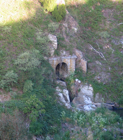
Photograph - Colour, Clare Gervasoni, Port Phillip Mine, Clunes, 2006, 07/12/2006
Remains of an arch structure on the site of the Port Phillip Mine at Clunes, Victoria.port phillip mine, clunes, mining -
 Ballarat Heritage Services
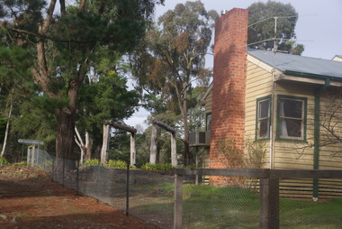
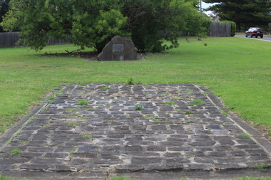
Photograph - Photograph - Colour, Site of the Portland Immigration Depot, 30/12/2016
The Portland Immigration Depot was established in 1843.Colour photograph of bluestone oin a grass lawn in Portland. It is the site of the Portland Immigration Depot.portland, immigration, bluestone, portland immigration depot, maria ross -
 Ballarat Heritage Services
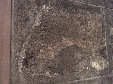
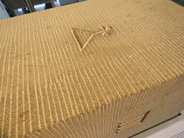
Digital Photograph, Stonemason's marks, Durham, UK, Friday, 21 October, 2016
These photographs show a reproduction of maker's marks on stone. Taken at Durham World Site Visitor Centre. -
 Ballarat Heritage Services
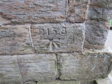
Digital Photograph, Stonemason's mark, exterior wall, Durham Cathedral, UK, 21 October 2016
Durham Cathedral is on a World Heritage Site, and the first stones were thought to be laid around 1000 - 1100 AD. Thus many marks in the stones in this cathedral are thought to date from this time. -
 Ballarat Heritage Services
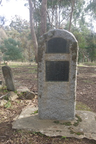
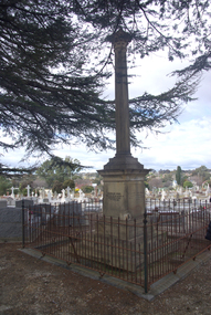
Photograph - Photograph - Colour, Burke and Wills Memorial at Bendigo Cemetery, 2018, 02/09/2018
Robert O'Hara Burke and Thomas Pope Besnard were childhood friends. As sexton of the local Back Creek Cemetery Thomas Besnard organised a subscription to raise the money for a monument to Burke, Wills and Gray. A subscription of one shilling, no more and not less, was asked so all subscribers were equal. The Bendigo monument was designed by Adam Duncan and features a Corinthian column mounted on a foundation stone, topped with a Grecian urn draped with the Union Jack. The stone for the monument was quarried from New Chum Mine. The site in the Bendigo Cemetery was selected by Besnard so the monument was on a grass knoll well clear of any other graves. The design included landscaping with a path and garden beds that provided dignified access. The Burke and Wills Monument in Bendigo has been entered on the Register of the National Estate as being important for its association with historical events and developments associated with exploration in the early days of Colony of Victoria. Two conifers remain from the original group sent by Mueller of the Melbourne Botanical Gardens to develop the garden layout on the knoll. These two trees are listed as Significant Trees by City of Greater Bendigo. The foundation block was laid on 20 August 1862 by Chairman of the Bendigo Municipality, Charles Burrows – exactly two years after the Expedition left Melbourne. A half day holiday was declared by Bendigo Council, and a procession left the Bendigo Town Hall and marched to the cemetery where 8000 people were gathered and another 4000 lined the route. John King was unable to attend due to ill health. Chairman of the Municipality of Bendigo, Charles Burrows, gave a long address, and diaries of members of the expedition, the Sandhurst Almanac, the Bendigo Advertiser, the Bendigo Independent Evening News, photographs of the deceased, photographs of Public Buildings in Bendigo, a Sydney half sovereign and all the silver coins of the Realm were wrapped in a Union Jack and placed in a niche in the foundation stone. Fifteen months later a column was erected on the foundation stone after Besnard openly criticised the Memorial Committee for their lack of action. The Bendigo Advertiser was disappointed at the location of the monument preferring a more central location and in 1893 an attempt was made to move the monument to Rosalind Park. On 19 May 1893, Mr Minto, the City Surveyor of the Bendigo MunicIpality reported it would cost £25, and no other action occurred. In 1940 the land around the memorial was sold off as grave sites and the paths and garden beds disappeared with graves now surrounding the base of the monument. The Burke and Wills Monument in Bendigo Cemetery was entered on the Register of the National Estate for its association with historical events and developments associated with exploration in the early days of Colony of Victoria. Two conifers remain from the original group sent by Mueller of the Melbourne Botanical Gardens to develop the garden layout on the knoll. These two trees are listed as Significant Trees by City of Greater Bendigo.Burke and Wills Memorial at Bendigo Cemetery, 2018Erected by the people of Bendigo in honor of the Victorian Explorers, Burke, Wills, Gray and King who first crossed the continent of Australia. King alone surviving the privation and suffering under which his three brave ill-fated companions sank. A.D. 1862. Robert O'Hara Burke, leader of the Victorian Expedition, left Melbounre 24th August 1860. Reached Carpentaria 12th Feby 1861. Died on his return at Coopers Creek, 30th June 1861. Charles Gray, died also on his return at Polygorum Swamp. 17th April 1861. William John Wills, second in command, died also near Coopers Creek, 29th June 1861. bendigo cemetery, burke and wills, burke and wills memorial, william john wills, john o'hara burke, charles gray, polygonum swamp, coopers creek, victorian expedition, carpentaria, bendigo public cemetery, bendigo remembrance park, thomas pope besnard -
 Ballarat Heritage Services
Photograph - Photograph - Colour, Dorothy Wickham, Ballarat Female Refuge, 2000
Ballarat Female Refuge was established in 1867 by a group of 26 Ballarat ladies. It was moved to the present site in Scott's Parade in 1884. It is now a private residence.Postcard size colour photgraphs showing the interior and exterior of the Ballarat Female Refuge. ballarat femail refuge, welfare, town and city mission, alexandra babies home, baby, orphanage, sarah ellis -
 Ballarat Heritage Services
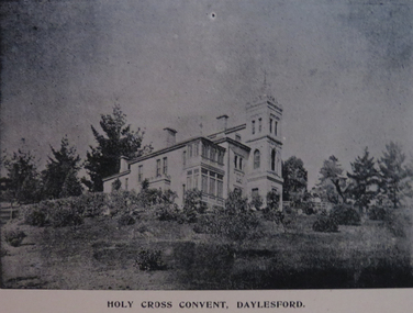
Photograph - Image, Holy Cross Convent, Daylesford, c1897
Holy Cross Convent is on the site of the Gold Commissioner's House, and it is incorporated into the architecture.Black and white image of the Daylesford Convent on Wombat Hill, surrounded by gardens. daylesford convent, presentation convent, daylesford, hold cross convent, daylesford -
 Ballarat Heritage Services
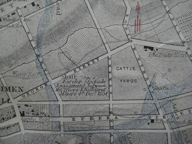
Photograph - Digital photograph, Map Detail Showing the Eureka Stockade site, 1861
Eureka Stockade is the site of the battle between government forces and miners and occurred on 3 December 1854 early one Sunday morning. Around 30 were killed, 130 arrested and 13 tried for High Treason. Many were injured in the affray. digital photographEureka Stockade Engagement between the troops and Ballarat Miners 4th December 1854. * Please note the date is recorded wrongly on the map.eureka site, map, george street, cattle yards, eureka street, ballarat, eureka stockade -
 Ballarat Heritage Services
Newspaper - Newspaper article, Newsclipping Relating to Stonemason Julien Hardy
Julien Hardy was the first discoverer of gold at Happy Valley. A stonemason, he was born at Vire, Normandy, France. He established a stone quarry on the Melbourne Road, near Warrenheip (on the site now occupied by Shady Acres Caravan Park). From here, he quarried blocks that were used in the Ballarat Town Hall.Newsclippingjulien hardy, stonemason, gold, happy valley, shady acres, warrenheip, ballarat town hall -
 Ballarat Heritage Services
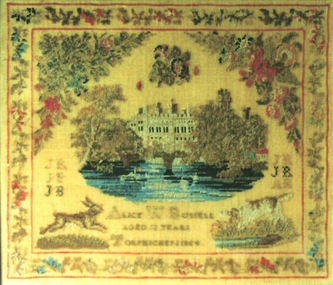
Photograph - Digital photograph, Tapestry
Alice Webb Russell embroidered this tapestry when she was 13 years of age in 1854 at Torphichen, Scotland. This is near Linlithgow Palace which is depicted in the tapestry. The initials of her family are at the side of the image. Torphichen is the site of the Preceptory of the Knights Hospitallers and is on the Scottish National Heritage.Photograph of a hand stitched tapesty.alice webb russell, torphicen, scotland, tapestry, embroidery