Showing 402 items
matching boundary street
-
 Ringwood and District Historical Society
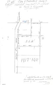
Document - Copy of Lands Department Field Notes - Parish of Ringwood, Victoria, Field Notes 1917/148 - Part of O.P. R72 - Crown Allotment 10, surveyed June 1917
5614b Foolscap size photocopy of survey map with handwritten notations. References include Wantirna Road, to Ringwood Station, Reilly Street, J. Marshall, fence to be erected on boundary, I certify that these notes are a true copy of observations and measurements made on the ground by me (signed) H.W. Moore 22/6/17. -
 Ringwood and District Historical Society
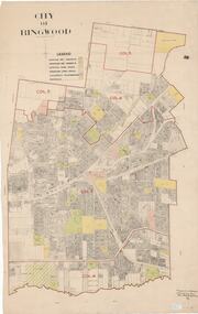
Map, City of Ringwood - Rateable Properties Layout - c.1966. Overlay showing Reserves, Open Space, Playgrounds, and Schools
A0-size (approx) map of named streets, lot-numbered properties and locality features within City of Ringwood boundary. Colour-coded legend identifying Existing Rec Reserves, Proposed Rec Reserves, Existing Open Space, Children's Playgrounds, and Schools.Scale: 8 chains to 1 inch. Map picked up in Engineer's office at old town hall prior to demolition 1971. -
 Ringwood and District Historical Society
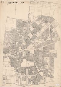
Map, City of Ringwood - Rateable Properties Layout - c.1966
A0-size (approx) map of named streets, lot-numbered properties and locality features within City of Ringwood boundary. Scale: 8 chains to 1 inch. City Engineer's signature in bottom right corner - Alan Robertson (City Engineer 1958-1987) -
 Ringwood and District Historical Society
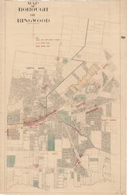
Map, Borough of Ringwood, Victoria - c.1950s
A0-size (approx) map of named streets and lot-numbered properties within Borough of Ringwood ward boundaries. Colour-coded key marking Land Under Control of Council, Factory Areas, and Business Areas.Scale: 8 chains to 1 inch. North Ward, East Ward, South Ward. -
 Ringwood and District Historical Society
Map, City of Ringwood - Rateable Properties Layout - c.1966
A0-size (approx) map of named streets, lot-numbered properties and locality features within City of Ringwood boundary. Coloured outlines of subsequent subdivisions. Seperate enlargement showing northern half of map.Scale: 8 chains to 1 inch. -
 City of Moorabbin Historical Society (Operating the Box Cottage Museum)
Newsletter, City of Moorabbin Historical Society Feb 2009, February 2009
The City of Moorabbin Historical Society was formed c 1960 by a group of Moorabbin residents who were concerned that the history of the area should be preserved. A good response to a call for items related to the historical area of Moorabbin Shire brought donations of a wide variety of artefacts which are now preserved by the current members of CMHS at Box Cottage Museum . Helen Stanley, Secretary of CMHS, began producing a Newsletter for members in April 2007 to provide current information and well researched items of historical interest.Helen Stanley has produced a bi-monthly Newsletter, 2007 - 2013, for the members of the City of Moorabbin Historical Society that contains well researched interesting historical items, notification of upcoming events, current advice from Royal Australian Historical Society , Museums Australia Victoria and activities of Local Historical Societies. The Newsletter is an important record of the activities of the CMHS. Tom Sheehy, past President of CMHS, was an Historian and Author of ‘Battlers Tamed the Sandbelt’. 2 x A4 paper printed on 3 sides Issue 10 of the bi-monthly, City of Moorabbin Historical Society Newsletter produced by Society member and Secretary, Mrs Helen Stanley in February 2009. The Victorian Bushfire tragedy around Marysville is still unfolding as this Newsletter is written. The first meeting for the year is February 22nd and subscriptions are due. An excerpt is transcribed from the City of Moorabbin Historical Society Newsletter October 1962, “A Piece of History in Ormond” by an unknown eyewitness author, describing the original “Box Cottage” situated in Mr J. Reitman’s cement products factory at 306 Jasper Road, Ormond prior to demolition. The current Editor gives information obtained from further recent research . An Article by Tom Sheehy, past President and Historian, February 1979 “The Vineyards of Moorabbin”. The ‘Brighton Estate” began when Henry Moor brought Vine cuttings from Camden NSW 1848 and they were productive after 3 years. Many Vineyards then appeared from Port Phillip Bay to East Boundary Road and produced 2/3 of the annual Victorian grape crop. Disease or insect caused failure in1858 and the land reverted to market gardens. A coloured photocopied photo of Box Cottage 2005. CITY of MOORABBIN HISTORICAL SOCIETY / FEBRUARY 2009 NEWSLETTERcity of moorabbin historical society, stanley helen, sheehy tom, melbourne, moorabbin, brighton, cheltenham, ormond, bentleigh, vineyards, fruit growing, vine diseases, winemaking, grapes, market gardeners, pioneers, early settlers, moorabbin shire, box cottage museum, dairy, port phillip bay, brighton estate, moor henry, cambden estate, reitman j., reitman w., cement, pottery, jasper road ormond, east boundary road brighton, dendy’s special survey 1851, point nepean road, south road brighton, thomas street brighton, north road brighton, county of bourke, box h., box william, bruton william, brighton brewery, parish of moorabbin, parish of prahran, markets, shingle roof, weather-board, downward mr., mckinnon -
 City of Moorabbin Historical Society (Operating the Box Cottage Museum)
Newsletter, City of Moorabbin Historical Society Apr 2009, April 2009
The City of Moorabbin Historical Society was formed c 1960 by a group of Moorabbin residents who were concerned that the history of the area should be preserved. A good response to a call for items related to the historical area of Moorabbin Shire brought donations of a wide variety of artefacts which are now preserved by the current members of CMHS at Box Cottage Museum . Helen Stanley, Secretary of CMHS, began producing a Newsletter for members in April 2007 to provide current information and well researched items of historical interest.Helen Stanley has produced a bi-monthly Newsletter, 2007 - 2013, for the members of the City of Moorabbin Historical Society that contains well researched interesting historical items, notification of upcoming events, current advice from Royal Australian Historical Society , Museums Australia Victoria and activities of Local Historical Societies. The Newsletter is an important record of the activities of the CMHS.2 x A4 paper printed on 4 sides Issue 11 of the bi-monthly, City of Moorabbin Historical Society Newsletter produced by Society member and Secretary, Mrs Helen Stanley in April 2009. Notice that Mr Travis Sellars, Friends of Cheltenham and Regional Cemeteries, will talk about ‘The Tragic 20’s’ at the meeting April 26th . Volunteers are needed to show visitors around on Open Days each month and a Roster will be made on April 26th . Suggestions are requested for the Community Grant Application to be submitted by CMHS. Historical details are condensed from ‘ The Living Harvest’ by W.T Dobson, describing the establishment of St. Peter’s Catholic School East Bentleigh 1865 on land donated by Fred Quinn , in Centre Road, East Brighton ( East Bentleigh). A photo copy of Parts of Country Portion 39 of Dendy’s Special Survey or Brighton Estate showing the Land Sales of Lot 2, & 3 North Road and Jasper Road 1841 – 1869. Interesting note on the origin of ‘Jasper Road’. 3 photocopied photographs of St Peter’s School building 1903, School Children at East Brighton Railway Station, 1903, A Lorry in the parade 1903. CITY of MOORABBIN HISTORICAL SOCIETY / APRIL 2009 NEWSLETTERcity of moorabbin historical society, stanley helen, dobson w.t., melbourne, moorabbin, brighton, friends of cheltenham and reional cemeteries, cheltenham, ormond, bentleigh, market gardeners, irish immigrants c1850pioneers, early settlers, moorabbin shire, box cottage museum, port phillip bay, brighton estate, jasper road ormond, east boundary road brighton, dendy’s special survey 1851, point nepean road, south road brighton, thomas street brighton, north road brighton, county of bourke, box h., box william, parish of moorabbin, parish of prahran, markets, shingle roof, weather-board, mr., mckinnon, were jonathan, niall rev. fr. patrick, quinn fred, elsternwick, catholic church directory 1878, hibernian society melbourne, brady peter., kennedy mr., boland mr., leary mr., gahan mr., archbishop carr, rev. fr. gough., presentation convent gardenvale, sister mary vincent, charlston john, bavarian dress band, hales jasper -
 City of Moorabbin Historical Society (Operating the Box Cottage Museum)
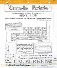
Flyer - Kinrade Estate, Bentleigh East
Kinrade Estate was not subdivided as shown in flyer. The land was purchased by Cyclone in 1950. Cyclone built a factory which manufactured wire material. This factory was closed in XXXX and a development firm purchased the land and subdivided the land into housing blocks.Example of the progress of the Municipality of MoorabbinAdvertising flyer for auction of real estate sales - plan of building blocks for saleleary avenue, charles street, peter leary, john joseph kinrade, tucker road, east boundary road, clover estate, kinrade estate, bentleigh, cyclone company, ardena court, bentleigh east -
 Bendigo Historical Society Inc.
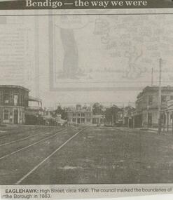
Newspaper - JENNY FOLEY COLLECTION: EAGLEHAWK
Bendigo Advertiser ''The way we were'' from 2000. Eaglehawk: High Street, circa 1900. The council marked the boundaries of the Borough in 1863. The clip is in a folder.newspaper, bendigo advertiser, the way we were -
 Bendigo Historical Society Inc.
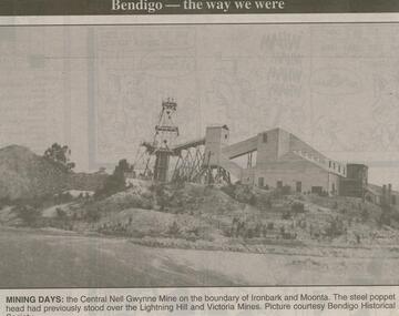
Newspaper - JENNY FOLEY COLLECTION: MINING DAYS
Bendigo Advertiser ''The way we were'' from 2000. Mining days: the Central Nell Gwynne Mine on the boundary of Ironbark and Moonta. The steel poppet head had previously stood over the Lightning Hill and Victoria Mines. Picture courtesy Bendigo Historical Society. The clip is in a folder.newspaper, bendigo advertiser, the way we were -
 Bendigo Historical Society Inc.
Photograph - BENDIGO TOWN HALL
... Street. Trees along north boundary of building. Gas lamps... down Hargreaves Street. Trees along north boundary of building ...Sepia image mounted on board. Image shows Bendigo Town Hall taken from north side, looking south down Hargreaves Street. Trees along north boundary of building. Gas lamps alongside kerb in Hargreaves Street. Market building visible alongside Town Hall.bendigo, buildings, bendigo town hall, bendigo, town hall, municipal buildings, hargreaves street -
 Bendigo Historical Society Inc.
Document - LET'S TRAVEL EAST IN 1858 - 60'S
Nine pages of handwritten account of businesses from Mitchell Street, along Lyttleton Terrace and McIvor Road to the City boundary on the Bendigo side of Murphy Street.document, let's travel east in 1858 - 60's, moorabbee sheep run, curr's sheep run, glasgow bakery, lachlan frazer, mr hardiman, steen and holm coach painters, mr h haisman coach builder, scholton and march, march and s brown, haisman factory, city hall, police court, city lockup, market square, senior citizens club, weighbridge, dunlop tyre service station, tommy burns, matt lynch, tom & mick kennedy, darling hotel, the innes, mr bullens fruit shop, bricklayers arms hotel, cheshire arms hotel, mr i boffey, newcombe's timber yard, quinns monumental establishment, alexandra fountain, cumberland hotel, sannaman's coach factory, town hall hotel, her majesties open air picture show, mr r anderson, john ohagan, sandhurst hotel, the melbourne café, haymarket hotel, the old haymarket hotel, the market ale house, the prince of wales theatre, manchester hotel, mr john doran, dr backhaus, manchester hall, the bendigo star, james griffen coach factory, mr george lansell, whitting's marine store, cartrights marine store, sandhurst flour mills, mr john buckley, moorhead hay and corn mills, brian boru hotel, mr m r?dea, mr worth, mr condon, mr c cahill, nolan family, mr sides, the nailons, mrs boyan, jacky bryant, john oconnell general store, mr pierce, mr matthews, mr neil ward, mr hagan, william clapton, mr joseph dowd, mr morris, ancient briton hotel, the woolpak, the railway bridge, ampol service station, farrells dairy, farringtons brickworks, jacksons hide & tallow yard, fergusons, royal oak hotel, mr jackson, mr knight, st marys common school no812, mrs rersol, w d quinn, mr march, mr fred randall, mr steeple, the limerick hotel, back creek police shooting range, police station, stone lockup, holts service station, steepe's butcher shop, joch, john hattam -
 Bendigo Historical Society Inc.
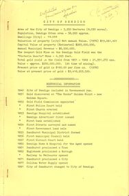
Document - ''CITY OF BENDIGO'': A DOCUMENT ''DISTRIBUTED FROM CIVIC OFFICES ON APPLICATION'' 1978
''City of Bendigo'' a document ''Distributed from Civic Offices on application'' 1978. two copies, a. and b. with different handwritten annotations. Contents - Historical Information 1840-1891; ''How Bendigo got its name''; ''Discovery of Gold''; ''Bendigo's Big Year, 1871; a history of Bendigo - in three pages; ''Education in Bendigo''; ''Information on mining in Bendigo''; Bendigo Council incl. elections, officers, revenue, ward boundaries, Mayoral Roll 1856 - 1977; Town Clerk Roll - 1856 - 1977; Town Hall details; 1891 Plebiscite; Coat of Arms details.bendigo, council, bendigo history, coat of arms, town clerk roll, mayoral roll, mining in bendigo, council elections. town hall details. -
 Bendigo Historical Society Inc.
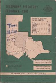
Book - TELEPHONE DIRECTORY FEBRUARY 1961, February 1961
Soft covered Telephone Directory February 1961. Districts covered are Bendigo, Castlemaine, Charlton, Deniliquin, Echuca, Kerang, Kyneton, Maryborough, Swan Hill. Cover has a green background with an outline of the map of Victoria in white. The Victorian Telephone directory boundaries are indicated and the district covered is shaded with black dots. Some handwritten jottings are written in ink on the cover. The directory contains both white and pink pages.book, bendigo, bendigo history & its people -
 Bendigo Historical Society Inc.
Book - JOAN O'SHEA COLLECTION: 150TH ANNIVERSARY OF BENDIGO BOOKLET, 1850 - 1950's
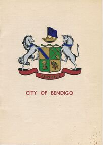
Joan O'Shea Collection. Buff Coloured Booklet City of Bendigo. 150th anniversary of Bendigo 1850s to 1950s. Image on cover coat of arms for City of Bendigo underneath word progress, left hand side horse, right hand side bullock. History of Bendigo: From Sheep Run to Provincial City in 100 years. Map of Bendigo and Surrounds Railways, Water Courses & Storage, Power, Municipal Boundaries & Land Available for Industry. Municipal District Creation 1855, Borough Proclamation 1863, Proclaimed City 1871, Area: 7992 Acres Population as of last census City of Bendigo 28,722, City of Bendigo and adjacent Urban Areas 36,909. City of Bendigo Map, The Past Prior to 1850. Icons of Bendigo The Bendigo base Hospital,Law Courts & Post Office, Primary Schools, Housing, Industry including Butter Production, Poultry Farming, Livestock Sales & Tomato Growing, Slaughter House & ordnance factory. The Present Recreation Photos: Bendigo Bowling Club, Queen Elizabeth Oval, Municipal Lawn Tennis Courts The Future of Bendigo, Bendigo Photographs From The 1950s,Cambridge Press Bendigobendigo, history, progress of bendigo 1850s on. -
 Bendigo Historical Society Inc.
Document - BENDIGO CITY INFORMATION BROCURE BARKLY WARD, 23 March 1991
Bendigo City Information Brochure Barkly Ward By-Election. Saturday, 23rd March, 1991. Brochure by the Bendigo City Council to assist Barkly Ward residents in casting their vote in Barkly Ward, 23 March, 1991. Authorised by R J Burton, Returning Officer. Map of Barkly Ward. Candidate Information, Lois Angus, David Anderson, Lynne Geri. Ward Boundaries. Hotline. Polling places: Senior Citizens Centre (Bendigo), White Hills Primary School, Lake Weeroona Pavilion, North Bendigo Scout Hall. Disabled Persons all Polling Places are accessible to disabled persons in wheelchairs.government, local, barkly ward, bendigo city information brochure barkly ward by-election. saturday, 23rd march, 1991. 23 march, 1991. authorised by r j burton, returning officer. map of barkly ward. candidate information, lois angus, david anderson, lynne geri. ward boundaries. hotline. polling places: senior citizens centre (bendigo), white hills primary school, lake weeroona pavilion, north bendigo scout hall. all polling. accessible to disabled -
 Bendigo Historical Society Inc.
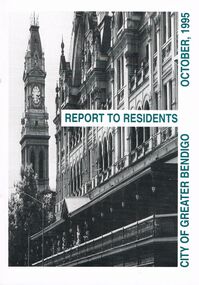
Book - BOOKLET: ''REPORT TO RESIDENTS CITY OF GREATER BENDIGO, OCTOBER 1995''
Front cover is a photo of The Shamrock Hotel. 52 paged booklet - ''Report to Residents - City of Greater Bendigo, October 1995''. Table of Contents; Commissioners; Chief Executive Officer; Council meetings; Office location and hours; ''One Telephone Number''; Committees; Ward boundaries; Elections; Customer services; Rural services; Economic development; Bendigo Tourism Board; Bendigo Trust; Events Bendigo; Capital works 1995/96; Major projects; Discovery; Bendigo Regional Arts Centre; local laws; Fire prevention; Aged and disability services; Children and family services; Environmental health; Recreation and leisure; Parks and gardens; Planning and building; Waste management; Library services; Bendigo Leisureland; Rates; Budget for 1995/96; Index. Contains some photographs and map of proposed 7 internal Wards for the City of Greater Bendigo.Richard Cambridge Printers Bendigo.bendigo, council, report, maxine crouch, maurie sharkey, perer ross-edwards, peter seamer, hadley sides, richard morriss, bernard smith, annie galvin child care centre, bendigo regional art centre, rosalind park, budget 1995/96. bendigo health care services. -
 Bendigo Historical Society Inc.
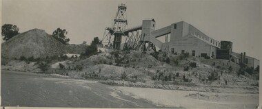
Photograph - CENTRAL NELL GWYNNE MINE
Black and white photograph of Central Nell Gwynne Mine on boundary of Ironbark and Moonta. This was one of three gold mines marked for assistance to commence the mining revival. This steel poppet head previously stood over the Lightening Hill Mine and firstly over the Virginia Mine. Bendigonians can access the site from Coath Street. Inscriptions: On back - 'MNG 53', 'Nell Gwynne' in lead pencil, 'Central Nell Gwynne' in black ink', 'Royal Historical society of Victoria, Bendigo Branch' circular blue stamp. History of object: previous Acc. No. MNG 53place, mining site -
 Bendigo Historical Society Inc.
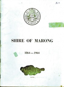
Book - SHIRE OF MARONG 1864 - 1964, 1964
Shire of Marong 1864 - 1964. A history of the shire. Contains Two (2) maps of the area on the inside back and front covers. Another illustration shows the division of the Electoral Boundaries and the types of Flora in each riding. At the back is an illustration indicating the break-up of the area with the names of The First Settlers (?) in these area. Blue cover. 36 pages. With index. B&W photos.book, bendigo, marong shire -
 Bendigo Historical Society Inc.
Document - CITY OF BENDIGO WARD BOUNDARIES
One page typewritten document titled City of Bendigo Ward Boundaries. The document details the boundaries of the Sutton, Darling and Barkly wards.government, local, city of bendigo -
 Bendigo Historical Society Inc.
Map - MAP WHITE HILL TO HUNTLY
Map of Bendigo creek and adjacent leads - White Hills to Huntly replotted from old 4 chain to 1 inch survey of 1860 by G. W. Hart - Surveyor. Base of roads and streets taken from D.L.S. 1 . 10000 base maps. Legend: battery site, puddling mill site, dam bank site, cutting altering course of creek, lead boundaries.bendigo, mining -
Bendigo Historical Society Inc.
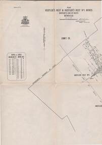
Map - HUSTLER'S REEF & HUSTLER'S REEF NO 1 MINES - PLAN OF THE HUSTLER'S REEF & HUSTLER'S REEF NO 1 MINES
Plan of the Hustler's Reef & Hustler's Reef No 1 Mines on the Hustler's Line of Reefs Bulletin No 33, Plate No XV. Plan shows the two mines with depth of levels, geological features and levels in relation to the shaft. Geological Survey of Victoria emblem and signed by H A Whitelaw, Underground Survey Office Bendigo, September 1913. Note - The Lease Boundaries shown on this plan are only in their approximate relative positions to Nos 13, Intermediate and 14 Levels of the Hustler's Reef No 1 workings, and Nos 15, 16 and 17 Levels of the Hustler's Reef workings.mining, parish map, hustler's reef & hustler's reef no 1 mines, plan of the hustler's reef & hustler's reef no 1 mines, geological survey of victoria, underground survey office bendigo, h a whitelaw, hustler's line of reefs -
Bendigo Historical Society Inc.
Map - HUSTLER'S ROYAL RESERVE NO 2 MINE - PLAN OF THE HUSTLER'S ROYAL RESERVE NO 2 MINE
Plan of the Hustler's Royal Reserve No 2 Mine on the Hustler's Line of Reefs Bulletin No 33, Plate No VI. Boundary of Leases No 8898 and 8897 shown. Various levels shown and some geographical features. Geological Survey of Victoria emblem. H . Harman, Director, W. Dickson, Secretary for Mines and The Hon. J. Drysdale Brown, Minister of Mines and signed by H Whitdon, Underground Survey Office, Bendigo, September 1913. This item has not been scanned or photographed.mining, parish map, hustler's royal reserve no 2 mine, plan of hustler's royal reserve no 2 mine, hustler's line of reefs, geological survey of victoria, h herman, w dickson, the hon j drysdale brown mlc, h whitdon -
Bendigo Historical Society Inc.
Map - HUSTLER'S ROYAL RESERVE NO 2 MINE - PLAN OF THE HUSTLER'S ROYAL RESERVE NO 2 MINE
Plan of the Hustler's Royal Reserve No 2 Mine Bulletin No 33, Plate No V. Plan shows the Hustler's Royal Reserve No 2 (Main Shaft), Hustler's Royal Reserve No 2 (Park Shaft.), the Royal Hustler's, the Imperial Hustler's and the Extended Hustler's Freehold on the Hustler's Line of Reefs. Also mentioned is the Lightning Hill Line of Reefs. Map shows some of the levels, approximate boundary of lease and the boundary of Lease No 8892 and 8897. There are also street names and the locations of jail, lagoons, Post Office, Rosalind Park and the State School, High School and Continuation School. Geological Survey of Victoria emblem. H. Herman Director, W. Dickson, Secretary of Mines and The Hon. J. Drysdale Brown MLC, Minister of Mines. Signed by zh Whitdan, Underground Survey Office, Bendigo, September 1913.mining, parish map, hustler's royal reserve no 2 mine, plan of the hustler's royal reserve no 2 mine, hustler's royal reserve no 2 (main shaft), hustler's royal reserve no 2 (park shaft), royal hustler's, imperial hustler's, extended hustler's freehold, geological survey of victoria, h herman, w dickson, the hon j drysdale brown, h whitdan, hustler's line of reefs, lightning hill line of reefs -
Bendigo Historical Society Inc.
Map - UNITED HUSTLER'S & REDAN & K. K. MINES - PLAN OF UNITED HUSTLER'S & REDAN & K. K. MINES
Plan of the United Hustler's & Redan & K. K. Mines on the Hustler's Line of Reefs Bulletin No 33 Plate No XXVII. Plan shows depth of levels, Long Gully, Hustler's Line of Reefs, Lightning Hill Line of Reefs and approximate Boundary of Lease. Also mentions Comet Co. Geological Survey of Victoria emblem and signed by H S Whitelaw, Underground Survey Office Bendigo September 1913.mining, parish map, united hustler's & redan & k. k. mines, long gully, hustler's line of reefs, lightning hill line of reefs, comet co, h s whitelaw, geological survey of victoria, underground survey office -
Bendigo Historical Society Inc.
Map - COMET MINE - LONGITUDINAL SECTION COMET MINE
Longitudinal section of the Comet Mine on the Hustler's Line of Reef Bulletin No 33, Plate No XXVI signed by H. S. Whitelaw, Underground Survey Office Bendigo, September 1913. Map shows datum lines, depths of levels, approximate boundaries and references to other plans. Note - Plates 4, 8, 13, 20, 26 and 31 form a Longitudinal Section from Fortuna Hustler's to Hustler's Consols Mine. This item has not been scanned or photographed.Geological Survey of Victoriamining, parish map, hustler's line of reef, longitudinal section of comet mine bulletin no 33 plate no xxvi, h s whitelaw, underground survey office bendigo september 1913 -
Bendigo Historical Society Inc.
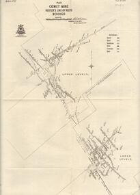
Map - COMET MINE - PLAN OF COMET MINE
Plan of the Comet Mine on the Hustler's Line of Reefs Bulletin No 33, Plate No XXIV signed by H S Whitelaw, Underground Survey Office Bendigo, September 1913. Upper and Lower Levels and approximate boundaries shown. Depths shown.Geological Survey of Victoriamining, parish map, hustler's line of reefs, comet mine plan bulletin no 33 plate no xxiv -
 Bendigo Historical Society Inc.
Map - COMET MINE - PLAN OF COMET MINE
Plan of the Comet Mine on the Hustler's Line of Reefs Bulletin No 33, Plate No XXIII. Map shows depths, Lightning Hill Anticline, Hustler's Anticline and approximate Lease Boundary. Signed by H. S. Whitelaw, Underground Survey Office Bendigo, September 1913. United Hustler's & Redan Co and Hustler's Reef Co also named on map. This item has not been scanned or photographed.Geological Survey of Victoriamining, parish map, hustler's line of reefs, comet line plan belletin no 33 plate no xxiii, lightning hill anticline, hustler's anticline, united hustler's & redan co, hustler's reef co, h s whitelaw, underground survey office bendigo september 1913 -
 Bendigo Historical Society Inc.
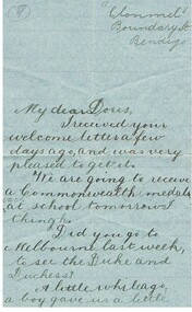
Document - MALONE COLLECTION: MACOBOY LETTERS, 1907
2 handwritten letters from Cecily Macoboy 'Clonmel' Boundary St Bendigo (now Valentine St) to her friend Doris. Also included is a piece of paper addressed to Doris from Kathleen. Part of this is written in French, and on the larger side what appears to be a song and the notes required to play this music.Cecily Macoboyperson, family, malone collection, malone collection, macoboy letters, cecily macoboy -
 Bendigo Historical Society Inc.
Map - STRUGNELL COLLECTION: HUSTLER'S LINE OF REEF, September 1913
Map, Hustler's Line of Reefs, Hustler's Reef & Hustler's Reef No.1 Mines Bendigo.Plate No. X1V (14) Comet Co. .Bulletin No 33 Signed H.A.Whitelaw. Drawing shows reef boundary lines .There is an explanatory box showing depth in feet and inches of the mines .Underground Survey Office, Bendigo.map, bendigo, hustler's reef & hustler's reef 1