Showing 259 items matching "cypress"
-
 Greensborough Historical Society
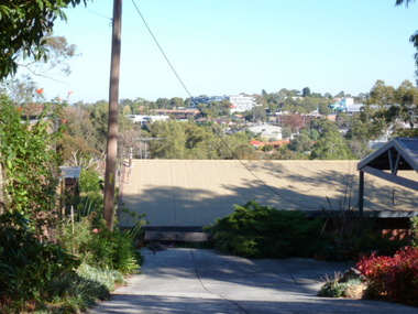
Photograph - Digital image, View of Greensborough from Delfin Crescent, 02/05/2013
This photograph of Greensborough was taken from Delfin Crescent in 2013 to show changes over 40 years, based on Ron Reynold’s sketches in the 1973 publication “Greensborough and Greenhills” published by Cypress Books. Delphin Crescent [previously known as Medhurst Street] was created about 1970 in association with the Delfin Building Company. It was at this time also, that major works on Diamond Creek Road raised the level of the road facilitating the connection of Delfin Crescent with Diamond Creek Road. [Note: 'Medhurst Street was only listed on planning maps pre 1950 when the 'street' had no residents or development.]Digital copy of colour photograph.greensborough and greenhills -
 Surrey Hills Historical Society Collection
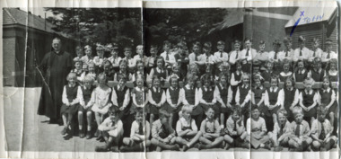
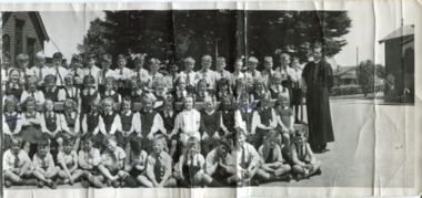
Digital photo, Our Holy Redeemer school photo, late 1950s, 1950s
School history - ref https://ourholyredeemer.cam.org.au/history In 1904 Fr. George Robinson erected a weatherboard school-hall where the present hall now stands. It was blessed and opened by Archbishop Carr on 20th November of that year. In January 1905, the Sisters of St Joseph took charge of the school. Archbishop Mannix opened and blessed the new brick school on 10th November 1918. From 1941-1972, Fr Tim Fitzpatrick was parish priest and head of the school. He is the priest on the LHS of this large school photo. Personal history: Although they lived in Prospect Street, Box Hill, John and Mary Turnbull attended Our Holy Redeemer School, as did Susan Hirst who lived across the road from the Turnbull family with her parents Ray and Shirley Hirst at 29 Prospect Street.Part of a large landscape black and white photo of a priest with a large group of children grouped as follows: Back row: 20 boys Second back row: 21 girls Second row: 16 girls Front row: 10 boys. Behind the group is a large cypress tree and to either side the church and (?) school building. The boy 4th from the right in the back row is marked with an 'x' in blue biro. This is part of a large landscape photo. The 2 pieces should be viewed as one. On front 'x' in blue biro is believed by the donor to have been made by Hughn Turnbull, his father. On rear in blue biro: "X JOHN" and " T MARY" plus in black in John Turnbull's hand "(MY SISTER)"; "SUSAN HIRST / SH (crossed out) / 3rd from RIGHT END" The donor has indicated that his father made the markings on the front of the photo. schools, our holy redeemer school, fr tim fitzpatrick, john turnbull, mary turnbull, susan hirst -
 Surrey Hills Historical Society Collection
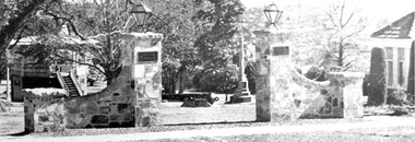
Photograph, View of Surrey Gardens looking east from Union Road
The 2 cannons in the gardens were acquired by Mr Arthur Brookes, popularly known as 'Empire Brookes'. They were from a British vessel used during the Crimean War and were originally placed in the grounds of the Guildford Road Recreation Oval. The Dimmick Gateway was erected in 1950 by the citizens of Camberwell in memory of Cr William Dimmick, JP, Mayor of Camberwell, 1935-1936 and a Councillor from 1934-1947. There is a photo of him in Mayoral robes in the City of Boroondara Library Service collection. Cr Dimmick was commonly called Roy.Black and white photo of the Dimmick Gateway in Surrey Gardens. The gateway is built as if it was designed to have a fence attached but there is none. There are 2 tall central pillars and an arched bridge to 2 smaller pillars. It appears to be constructed from a variegated slate material. There is a light on the top of each of the tall pillars and also a plaque. To the RHS of the photo is part of the Surrey Shrine, skirted by 2 cypress trees. A canon and the Memorial Cross can be seen between the gateway pillars and to the LHS of the photo the wooden bandstand can be seen.dimmick gateway, surrey gardens, surrey shrine, boer war, bandstand, parks and reserves, cr william dimmick, roy dimmick -
 Ballarat and Queen's Anglican Grammar School
Badge, Noopsi Badges celebrating 100 years of Anglican education
Ballarat Grammar’s 23 acre site facing Forest and Howitt Streets, Wendouree was chosen carefully by the Committee set up by the Church Assembly (Synod) in November 1908. Classes began for the 38 boys enrolled on 14 February 1911. The first building accommodated 90 day boys and 25 boarders. It comprised the Headmaster’s residence, three classrooms, one large dormitory, a small bathroom, two cubicles for assistant masters and the matron’s room. During the first year the property was fenced, trees and cypress hedges were planted, a carriage drive was constructed and work commenced for the School Cricket Oval. Three Noopsi Badges celebrating 100 years of Anglican education at Ballarat & Queens Anglican Grammar School. These are beaded badges in blue, yellow and brown with "100" in yellow, mounted on a safety pin. "100" in worked in yellow beadsballarat, badge, queens, 100, cegs, 2011, bgs, noopsi, century-celebration, grammar-school, qceggs -
 Surrey Hills Historical Society Collection
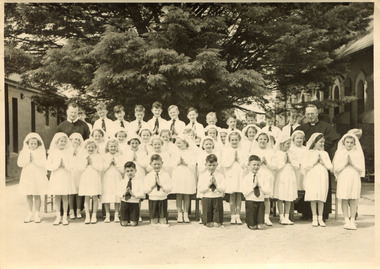
Digital photo, Our Holy Redeemer First Communion class, 1951, 1951
According to the donor, Fr Fitzpatrick is the priest on the RHS of the Communion group.This is one of a series of photos that document John Turnbull’s First Communion. They are representative of this important rite of passage in the Catholic Church in the 1950s. The sacrament of First Communion is an important tradition for Catholic families and individuals. Originally this was celebrated when a child was 10, 12 or even 14 years of age, however in 1910, Pope Pius X issued the decree Quam singulari, which changed the age at which First Communion is taken to 7 years old. Traditions of celebration surrounding First Communion usually include family gatherings and parties to celebrate the event. The first communicant wears special clothing. The clothing is often white to symbolize purity. It is more elaborate for girls but boys wear ‘Sunday best’; it could be a suit and tie or even a tuxedo. Many families have formal professional photographs taken in addition to candid snapshots in order to commemorate the event and some churches arrange for a professional photographer to attend after the ceremony. A black and white photo of 16 visible boys (plus one additional boy almost completely obscured to the right of the group), 23 girls and 2 priests. The boys are wearing shorts and white shirts with ties. The girls are wearing white dresses and veils. The children are grouped with 12 boys in the back row and 4 kneeling in the front. The girls are in the front and centre rows and the priests are either side of the group. Behind the group is a large cypress tree and to either side the church and (?) school building. One of the boys is John Turnbull. On rear in black ink: "John's 1st COMMUNION / 1951 / JOHN IS BACK ROW / 2ND FROM LEFT". our holy redeemer church, our holy redeemer school, john turnbull, fr tim fitzpatrick, first communion, children -
 Surrey Hills Historical Society Collection
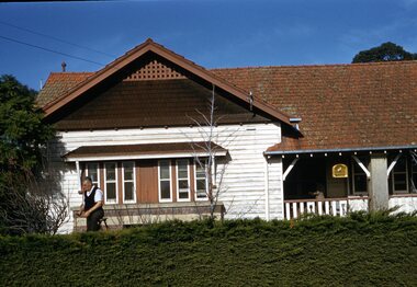
Photograph - Digital photograph, George L Coop, 688 Whitehorse Road, Mont Albert 1958, 1958
The gentleman in the photo is George Burton Coop, an architect / draughtsman. The donor, his son George Lister Coop was about 21 years of age when he took this photo in 1958 of his family home. His parents were: George Burton Coop (b c1906 Williamstown; died aged 54 years at Mont Albert) and Winsome Alice (MS: Trewartha) who married in 1936. They are first listed at this address in the electoral roll in 1937. They had 2 children: George Lister Coop - born St Georges Hospital, 8/10/1937 and Alison - born c1945. However the donor informed that he initially attended Chatham State School because his first home was the Spanish Mission style flats at 346 Whitehorse Road, opposite Brenbeal Street, Balwyn. When his grandparents died, the family moved to 688 Whitehorse Road and he then attended Mont Albert Central School. Alison being younger did not go to Chatham Primary. A digital copy of a colour photo showing detail of the front view of 688 Whitehorse Road. The house is white weatherboard in a Californian bungalow style with a tiled roof and shingles detail in a dark brown stain. The balustrades and finials of the veranda are simple with occasional feature planks with a tulip detail. A bird cage hangs from the veranda. The veranda is supported by rough-cast sturdy pillars. The house sits behind a cypress hedge. The photo was taken in winter as deciduous shrubs are bare. A gentleman astride a ladder is pruning the hedge. george l coop, whitehorse road, mont albert, californian bungalow, cypress hedge, gardening, george burton coop -
 Surrey Hills Historical Society Collection
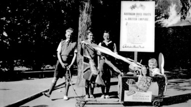
Photograph, Chatham students support the Empire, Surrey Hills, c 1947, 1947
The billycart was possibly decorated for celebrations associated with Empire Day. Image was originally copied by Chatham Primary School for inclusion in their pictorial history "A Patchwork of People - Chatham Past and Present" [ISBN 0 646 29370 2], by Susan Barnett and Julia Ashby, published in 1996 for the school's 70th anniversary. Copied for the SHNCHC with the school and donor's permission. There is also a laminated copy of it for display purposes.Black and white image of four boys and their billycart. Two are identified as Bruce Hansen, standing behind the flag and Jimmy Boyd, seated in the billycart, which is decorated with streamers, an English flag and advertising signs promoting Australian sultanas and the export of Australian dried fruit to the [British] Empire. The photo was taken in the grounds of Chatham Primary School. In the background can be seen some of the cypress trees that were planted along the side of the oval, a remnant eucalypt from the time when the land was part of J B Maling's farm and part of the shelter shed.chatham primary school, billycarts, advertising signs, empire day, bruce hansen, jimmy boyd -
 University of Melbourne, Burnley Campus Archives
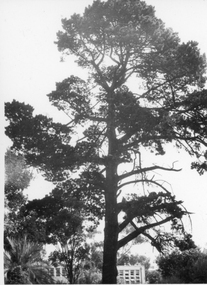
Photograph - Black and white print, Miscellaneous Photographs, Unknown
trees, garden views, fruit tree pruning, lagoon paddock, orchard, principals residence, pinus canariensis, sequoia sempervirens, pinus radiata, butia capitata, emily gibson bed -
 Surrey Hills Historical Society Collection
Digital photo, Our Holy Redeemer school photo, late 1950s (Part 2), 1950s
School history - ref https://ourholyredeemer.cam.org.au/history In 1904 Fr. George Robinson erected a weatherboard school-hall where the present hall now stands. It was blessed and opened by Archbishop Carr on 20th November of that year. In January 1905, the Sisters of St Joseph took charge of the school. Archbishop Mannix opened and blessed the new brick school on 10th November 1918. From 1941-1972, Fr Tim Fitzpatrick was parish priest and head of the school. Personal history: Although they lived in Prospect Street, Box Hill, John and Mary Turnbull attended Our Holy Redeemer School, as did Susan Hirst who lived across the road from the Turnbull family with her parents Ray and Shirley Hirst at 29 Prospect Street.Part of a large landscape black and white photo of a priest with a large group of children grouped as follows: Back row: 19 boys Second back row: 14 girls Second row: 15 girls Front row: 12 boys. Behind the group is a large cypress tree and to either side the church and (?) school building. The girl in the 2nd row, first on the left is marked with an 'T' in blue biro; the girl 3rd from the right in the same row is circled in blue biro. There is a Californian bungalow in the background. This is half of a large landscape photo and the 2 pieces should be viewed together. On front 'T' and a circle in blue biro are believed by the donor to have been made by Hugh Turnbull, his father. On rear in black: "OUR HOLY REDEEMER - SURREY HILLS / PROBABLY 1950's" schools, our holy redeemer school, fr tim fitzpatrick, john turnbull, mary turnbull, susan hirst -
![Photograph - Digital image, House St Helena and Diamond Creek Roads [Greensborough], 02/05/2013](/media/collectors/4f729f5697f83e03086015b8/items/5729bbd22162f108e8de5be2/item-media/5729bc112162f108e8de617d/item-fit-380x285.jpg) Greensborough Historical Society
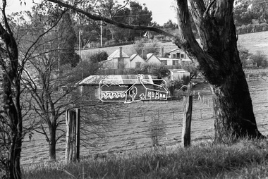
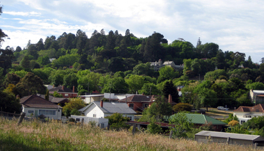
Greensborough Historical SocietyPhotograph - Digital image, House St Helena and Diamond Creek Roads [Greensborough], 02/05/2013
These photographs of the house on the corner of St Helena and Diamond Creek Roads was taken in 2013 to show changes over 40 years, based on Ron Reynold's sketches in the 1973 publication 'Greensborough and Greenhills' published by Cypress Books... which states "Built on a steep hill in a bush setting in the early 1920s, for a Dr Wood, the weatherboard house now overlooks an area of activity and change. The owners, Mr and Mrs E. 'Bluey' Blackburn, remember when their 3/4 acre building block dropped to the edge of a dirt road. Today the view from the high verandah encompasses the Main Street shopping centre, new and old bridges, new roads and houses, the Plenty River, natural bush, hills and sports grounds."Digital copy of colour photograph.greensborough and greenhills, st helena road greensborough, diamond creek road greensborough, wood family, ron reynolds -
![Photograph - Digital image, Kelly Garden Supplies [Greensborough], 02/05/2013](/media/collectors/4f729f5697f83e03086015b8/items/5729bced2162f108e8de6b52/item-media/5729bd212162f108e8de74aa/item-fit-380x285.jpg) Greensborough Historical Society
Greensborough Historical SocietyPhotograph - Digital image, Kelly Garden Supplies [Greensborough], 02/05/2013
This photograph of the former site of Kelly Garden Supplies was taken in 2013 to show changes over 40 years, based on Ron Reynold’s sketches in the 1973 publication “Greensborough and Greenhills” published by Cypress Books. The site is now part of the Civic roundabout at the top of the Greensborough By-pass. Civic Drive was associated with the building of Diamond Valley Council Offices opened by Governor Rohan Delacombe on 26/2/1972. Previously it was known as Kelly's Track which wound its way around to a house that overlooked the aqueduct bridge. Kelly's Sandpit (quarry) was the local go to place to obtain road, driveway fill and red sand for local construction. For 80 years previous Kelly's quarry supplied sand to the greater Melbourne area for the surfacing of school grounds, parks etc. Digital copy of colour photograph.greensborough and greenhills, civic drive greensborough, kelly garden supplies, ron reynolds -
 Coal Creek Community Park & Museum
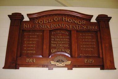
Honour Roll, Kilcunda Road School Honor Roll
This WWI Honor Roll was originally displayed in the Kilcunda Road State School (no.3337), which was located at the north east corner of the intersection of the Bena - Kongwak and Buchanans' Roads, Bena, Victoria, 3946. The school was located amongst the cypress trees at 645 Bena-Kongwak Road. The school was relocated in 2008 to the Coal Creek Community Park and Museum, 12 Silkstone Road, Korumburra, 3950 to become the Masonic Lodge building in the park display. On the west side of the intersection of the Bena - Kongwak and Buchanans' Roads is a brass plaque on a granite boulder with the following inscription TO COMMEMORATE THE DISTRICT OF KILCUNDA ROAD First Surveyed 1879. This is the site of the KILCUNDA ROAD UNITING CHURCH 1911 to 1966. Diagonally opposite at 645 Bena-Kongwak Road was the site of the KILCUNDA ROAD PRIMARY SCHOOL No: 3337, 1902 to 1975. Erected by The School Mother’s Club continuing as The Kilcunda Road Social Club 2008. One of the few remaining historic items from Kilcunda Road settlement.Honour roll of varnished wood, with three panels, an undulating shaped pediment, plain columns at sides, painted gold text and the Australian Imperial Forces insignia on base.Roll of Honor, Kilcunda Road State School. In Honor of Old Scholars of this school who served the Empire in the Great War, 1914-1919, Australian Imperial Force. (X) These made the supreme sacrifice. Sister J.E. Turner , E.N. Barge, E.F. Binding (X), E.H. Bunn, D. James (X), W.James, A. James (X), R. H. James, A.G. Rose (X), C.W. Stanlake, G. Wuchatsch, R. Wuchatsch, T.E. Young kilcunda road, honour roll, state school no.3337., wwi -
 Cheese World Museum
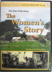
DVD, On our selection: the women's story
This is the story of the women of the bush, women who performed more than the traditional duties of wife and mother. They worked alongside their men, through good/times and bad and they were rare to complain. Six former country women of the Portland/Heywood district provide us with a snapshot of life as it was from the 1920's through to the 1960's. They speak about their own and their mother's lives, lives which have experienced the greatest material and personal changes in history. The story of the 'Remarkable Mary Stuchbery' details the struggles of a wife and family whose husband/father contracted polio shortly after returning from WWII service. Garry Kerr has produced a series of local history stories, initially for the Heywood [history group] and more recent items privately.The material contained in these interviews provides a first-hand insight into the experiences of women who were involved in carving farms from virgin bush. Their recollections of work, social activities and opportunities for their children are an invaluable primary source.Full colour DVD cover featuring image of old hip-roof weatherboard house with front verandah and skillion roof to rear with stone chimney attached to outside. Corrugated iron roof is rusty. To the left is an outbuilding. Picket and wire fencing is in the foreground, background has large cypress tree to left and gum to right. At the bottom is a series of three black and white images showing (L-R) three women in working clothes and a woman holding a baby; woman chopping wood; woman milking cow with young boy standing beside her. The back cover is yellow with images of the seven women featured showing coloured images of the interviewees beside black and white images of the interviewees when young. DVD features the same images as the front cover.Garry Kerr's LOCAL HISTORY Series 5/On Our Selection/The/Women's/Story/Produced by Garry Kerr (front) WOMEN WERE THE UNSUNG HEROES OF THE BUSH/This is the story of the women of the bush [see historical information] ... Running time 74 minutes/Plus an additional 30 minutes of/'The Remarkable Mary Stuchbery' -
 Southern Sherbrooke Historical Society Inc.
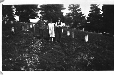
Photograph - Percy Johns, 1930s
B&W photo of Percy Johns, an unknown woman and a farm worker during potato digging at Glen Park Farm, Selby, in the 1930s. Percy Johns stands on the left, wearing a dark hat, jacket with deep pockets, and pants. He is holding a shovel in his right hand, and his left hand is on his hip. Beside him is a young unidentified woman with dark hair, who is wearing a loose dress with a drop waist. Beside her is an unidentified farm worker, wearing a hat, dark waistcoat and pants, and pale shirt. He has a pipe in his mouth. They are standing between rows of potatoes. On the left of the photo there is a row with potatoes lying on the ground. There are at least eight full bags of potatoes in the field. Behind the trio is what appears to be the cypress avenue running down to the homestead out of range on the right of the photo. -
 The Beechworth Burke Museum
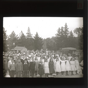
Photograph - Lantern Slide, c1900
This glass slide depicts a group of school children standing in Queen Victoria Park (previously Beechworth Botanic Gardens), circa 1900. Queen Victoria Park was first secured in 1858 by the Beechworth Council with the assistance of the Central Board of Health (CBH). The CBH was a firm believer in the socially beneficial effects of parks and other recreation areas which is why they aided the council in securing the parkland. the council held a local competition for the design of the park and decided on a plan called "Better late than never" by Hungarian nobleman, J.A. Rochlitz. The first non-native trees were planted in 1861 and have since been heritage listed on the National Trust's register of significant trees. There are nine trees located in Queen Victoria Park that are currently on the National Trust's register. These are the Loblolly Pine, Italian Cypress, Shore Pine, and the Big Cone Pine. These trees hold significance as they date back to 1875 and show rare and localised examples of these types of species which are not seen in many other places in Victoria. The trees in the background of the glass slide depict a species of the pine tree and may be some of the trees still standing in Queen Victoria Park today.This glass slide captures social and historical significance as it not only captures a moment in time of these school children, but it also shows environmental significance for the heritage trees depicted in the background.burke museum, beechworth, lantern slide, slide, glass slide, plate, burke museum collection, photograph, monochrome, queen victoria park, indigo shire, school, j.a. rochlitz, beechworth council -
 Glen Eira Historical Society
Document - GLEN HUNTLY
This file contains 3 items about land subdivision and development in Glen Huntly: 1/1 colour real estate advertisement (undated) for the auction of lots of land in Glen Huntly Park Estate, Glen Huntly to be held 06/12/1930. The poster includes1 black and white photograph (85mm x 201mm) of the Shopping Centre on Glen Huntly Road and a colour map (95mm x 107mm) of the Estate and surrounding locality. Also included on the poster is 1 black and white photograph of the Glen Huntly Park Estate and Cypress Plantation of the Glen Huntly Park. 2/1 undated advertisement for an auction of land in Glen Huntly Park to be held 19/03/1938 pursuant to an order to an order for sale made by the Supreme Court of Victoria. It includes 1 black and white photograph (52mm x 375mm) of shops along Koornang Road and 1 black and white photograph (52mm x 375mm) of shops along Glen Huntly Road. 3/1 black and white aerial photograph (undated and unattributed) (164mm x 272mm) of Glen Huntly Park Estate and surrounding area, with street names added, which indicates the second section of the Estate for sale.glen huntly, grange road, glen huntly road, watson crescent, garden avenue, wattle avenue, park avenue, mckay avenue, neville street, miller street, morgan street, truganini road, koornang road, glen huntly park and recreation reserve, glen huntly park estate, royal avenue, glen huntly railway station, tram depots, lyons street, moira avenue, katandra road, ormond, mimosa road, glen huntly park pty ltd, city of caulfield, lord h, land sales, auctions, parks and reserves, shops, elsternwick, caulfield -
 Eltham District Historical Society Inc
Photograph, George Coop, Carrucan's Dairy on Dalton Street, Eltham, c.1969, 1969
Viewed from intersection of Mount Pleasant Road and Metery Road looking northwest. The dairy is in the foreground situated on Dalton Street. An unmade Bible Street can be seen running down the hill at the left to intersect with Dalton Street. Dalton Street runs from left to right between the dairy and the Carrucan family home opposite located on the southeast corner of Bible and Dalton streets. Doug Orford recalls the dairy was at a slight angle to Dalton Street. Tim Erickson, (a nephew to Betty Erickson, nee Carrucan) reacalled (9 May 2025): the bottom front paddock ran from MeteryRoad to Mount Pleasant Road The brick dairy from 1thje 1950s had 10-15 milking cow , Jersey and Guernsey6 and the used to send the cream to Eltham Dairy The garage when Tim was a child used to house a couple of sulkies The laundry was a local home built job The small house built late 1940s for Betty Carrucan for her family The small orchard grew Quince, Apple and Plum The main block was the upper paddock Cypress trees remain present as of 2025 Originally 2 buildings but a third was added in the early 1900s for a kitchen and diningDigital TIFF file Scan of 35mm Ilford HP4 black and white transparencybible street, carrucan dairy, carrucan home, dalton street, eltham, mount pleasant road -
 Eltham District Historical Society Inc
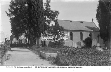
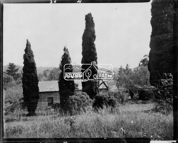
Photograph, The Rose Stereograph Company, St. Katherine's Church, St Helena. Greensborough, c.1936
View of St Katherine's Church from the path inside the Memorial Gate. Also visible several Mediterranean Cypress trees. A prominent gravestone for the Mapleton and Ellis families visible to the far left of the path. St Katherine’s Anglican Church was built in 1858, by Anthony Beale as a memorial to his late wife Katherine. The cemetery is a rare example in Victoria of a traditional English parish church with its private graveyard and is of State Significance. Rose Chapel with its stained-glass windows of local historical significance, commemorates casualties of the Beale family in World War One. This glass plate negative was used to manufacture postcards (1:1 printing) for commercial sale by the Rose Sterograph Company and its subsidiaries. George Rose founded the Rose Stereograph Company in 1880 and was joined by Herbert (Bert) Cutts in the early 20th Century. The pair formed a lifetime working partnership and strong personal friendship. Assisted by George’s two sons, Herbert George and Walter, and later by Neil Cutts, the Rose Stereograph Company continued its operations for more than 140 years. The company was initially built on stereographs, but as cinema took over and stereographs fell out of fashion, the Rose Stereograph Company developed Australia’s first commercially viable photographic postcard business. Specialising in postcards of iconic historical moments and significant landmarks, The Rose Stereograph Company became a staple of the Australian travel industry.This remarkable collection of glass plate negatives, transparencies, and postcards – arguably Australia’s most significant photography collection outside of public hands – has been passed down through the generations, surviving war, relocation, and the harsh Victorian climate. The historic Rose Stereograph collection is the culmination of George Rose’s dream of capturing and preserving precious moments in time and remains the legacy of the Rose and Cutts families. It is with great sadness that the Cutts family says goodbye to a collection that spans five generations and 140 years. The Cutts family understands that for these historically important pieces to rest with one family is to deny others the pleasure of their custodianship.Glass Plate Negative Size: 9.2 x 14 cmSt. Catherine's Church, St Helena, Greensborough, Published by W. M. Butterworth No. 1postcard, travel, rose stereograph company, glass plate negative, greensborough, st helena, w. m. butterworth, st katherine's church, memorial gate, mapleton, ellis, mediterranean cypress, peter and elizabeth pidgeon collection -
 Eltham District Historical Society Inc
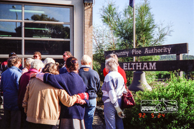
Photograph, Eltham Fire Station, Main Road, Eltham Heritage Tour, 24 May 1992, 24/05/1992
ELTHAM HERITAGE TOUR The Society excursion on 24th May 1992 was arranged by David Bick, leader of the team carrying out the Shire's heritage study. David selected a number of sites or buildings identified in the study, some of them lesser known components of the Shire's heritage. The tour commenced at the Eltham Shire Office at 10.00 am. Travel was by private car and mini-bus with stops at about twelve locations for commentary by David.It included a short walk in Hurstbridge and lunch at Kinglake. Highlights of the tour included: - 10 am Leave from Shire Offices - 3 Important Trees - A Physical Link to Eltham's First Settlers - Toorak Mansion Gates - A Surviving Farm House - An Intact Circa 1900 Main Street - First Settlers - Gold Miners, and Timber-getters - An Early Hotel - A Pioneering Homestead - Changing Eltham Shire - 20th Century - 4 pm Afternoon Tea and Finish Tour Extract from ELTHAM CULTURAL HERITAGE TOUR (Newsletter No. 85, July 1992, by Bettina Woodburn) "Commencing with a quick walk to see the magnificent bell at the Eltham Fire Station, we then 'drove along Arthur Street. Here were examples of what constitutes the building environment of Eltham. Massed among the wattles and eucalypts were golden cypress and pines; No. 50 was an exotic 'old English' manor-house; No. 93 had bluestone gateposts, from Fenton Road Toorak (as with Montsalvat, using re-cycled building material was very much the trend); past the natural Reserve dedicated to the artist Walter Withers, a plaque on a huge boulder; and on both sides houses in the various modes - timber with wrought iron decor, brick-some more recent than others, decades of 'suburbia'."Record of the Society's history and activities and highlighting various aspects of the Heritage Study undertaken by David Bick used to create the future heritage overlay for the Shire of Eltham and later Nillumbik Shire.Roll of 35mm colour negative film, 4 stripsKodak Gold 100 5095eltham, main road, shire of eltham historical society, activities, heritage tour, cfa -
 Eltham District Historical Society Inc
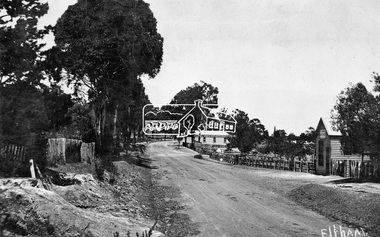
Negative - Photograph, Tom Prior, Main Road near Eltham Railway Station, c.1910
View looking south along Main Road, Eltham from near present day Luck Street. On the immediate right is a fence with the words “Hot Water” painted on it followed by William J Capewell’s butcher shop, then the slaughter yard and saleyards with the entrance access to the railway station. Contained within the saleyards facing the street, a small shelter with the name H.H. Clark upon it. Horace Harold Clark was the son of Eltham State School’s first Head Teacher, David George Clark. As well as being a farmer, he was an Estate Agent and conducted auction sales, presumably from this shelter. The large weatherboard building on the corner (opposite present-day Arthur Street) with signs for Summer Drinks and Hot Water painted on the side is Luther and Ada Haley’s General Store and Bakery, built 1902. This was the first building in what is now Eltham’s present shopping town centre. Haley previously ran the General Store and Bakery on the corner of Main Road and York Street until his lease expired and the premises were bought by Mrs Sarah Burgoyne in 1902. The store later was known as Staff's Store. In the distance approximately mid-way between the Butcher shop and the Bakery are the tops of what appears to be two cypress trees, which could well be the trees in front of the Shillinglaw Cottage facing Main Road. On the eastern (left) side of Main Street is Haley’s Paddock, which was used on occasions for community picnics. Capable of holding 10,000 people, with ample shade and hilly surroundings it was an ideal place for any community gathering such as the State Schools’ Picnic in 1904. Picture dated as c.1910 based on similar picture published in the Weekly Times, Feb. 1912. Kerb and channelling added 1923. Cross Ref: 610 (looking north), 611 (later stage), 613. Same as 705 (though in better condition)This photo forms part of a collection of photographs gathered by the Shire of Eltham for their centenary project book,"Pioneers and Painters: 100 years of the Shire of Eltham" by Alan Marshall (1971). The collection of over 500 images is held in partnership between Eltham District Historical Society and Yarra Plenty Regional Library (Eltham Library) and is now formally known as the 'The Shire of Eltham Pioneers Photograph Collection.' It is significant in being the first community sourced collection representing the places and people of the Shire's first one hundred years.Digital image 4 x 5 inch B&W Neg 120 format B&W negative (spare)shire of eltham pioneers photograph collection, eltham, main road, butcher, eltham railway station, railway station, w.j. capewell, baker, eltham town centre, general store, luther haley, reynolds prior collection, shops, haley's paddock, hot water, m.m. clark, sign, summer drinks, eltham sale yards, eltham slaughter yard, staffs general store -
 Eltham District Historical Society Inc
Negative - Photograph, Shillinglaw Cottage, 17 Oct. 1963
Shilinglaw Cottage in its original location on Main Road Eltham with the three Mediterranean Cypress trees (“Shillllinglaw trees”) in the garden. Note a fourth pine to the right. This image was taken shortly before its relocation. Believed to be have been taken by John Collins, 17 Oct 1963 as per other images held by the State Library of Victoria Author / Creator: John T Collins 1907-2001 , photographer. J.T. Collins Collection, La Trobe Picture Collection, State Library of Victoria. Shillinglaw Cottage is significant to Eltham’s local history. It is one of the earliest known buildings still in existence. Records suggest that the cottage was built circa 1859 by a man named Cochrane, believed to be Thomas Cochrane, in conjunction with George Stebbings though it is not known what Stebbings’s contribution was. It is made from hand made bricks laid in a Flemish bond pattern. In the 1960s it was marked for demolition to make way for the construction of new council buildings but a community campaign saved the cottage and it was re-located. It is believed Stebbings owned the cottage between 1874 and 1888. According to Margaret Ball’s (2017) book Shillinglaw Family of Eltham 1660-2007, Thomas Cochrane and family lived there from 1867 to 1874 however this is contrary to the records of assessable rates levied by the Eltham District Road Board, established in 1858, which shows Cochrane was the owner occupier (in Little Eltham) of approximately 25 acres of cultivated land and 25 acres of pastureland upon which a hut was sited in 1860. It is suspected that George Stebbings may have acquired the property from Cochrane in 1874 as it is noted that he had a tenant for a period, James Rossiter, who was the editor for the Evelyn Observer in Kangaroo Ground in 1874 (LATE SHIRE OFFICE AT KANGAROO GROUND (1934, February 16). Advertiser (Hurstbridge, Vic. : 1922 - 1939), p. 5. Retrieved February 25, 2022, from http://nla.gov.au/nla.news-article56743657). In 1881 Phillip Shillinglaw became the ratepayer for the cottage though Stebbings retained ownership until 1888 at which time it was transferred to Shillinglaw.Shillinglaw Cottage is itself historically, aesthetically and socially significant to the Shire of Nillumbik and is registered on the Victorian Heritage Database. This photo forms part of a collection of photographs gathered by the Shire of Eltham for their centenary project book, "Pioneers and Painters: 100 years of the Shire of Eltham" by Alan Marshall (1971). The collection of over 500 images is held in partnership between Eltham District Historical Society and Yarra Plenty Regional Library (Eltham Library) and is now formally known as 'The Shire of Eltham Pioneers Photograph Collection.' It is significant in being the first community sourced collection representing the places and people of the Shire's first one hundred years.Digital image 4 x 5 inch B&W Negsepp, shire of eltham pioneers photograph collection, eltham, shillinglaw cottage, significant tree -
 Ballarat Heritage Services
Photograph - Digital photographs, L.J. Gervasoni, Snow at the Wombat Hill Botanic Gardens, Daylesford, c2012-2016
The Daylesford Botanic Gardens are of historic, scientific (botanic), and aesthetic significance to the State of Victoria. The Daylesford Botanic Gardens are historically significant as a fine example of a regional botanic garden demonstrating the typical characteristics of a carriage drive, informal park layout, decorative structures and works such as the memorial tower, conservatory, rotunda, cascade and fernery, which contrasts with the open lawns planted with specimen trees, areas of intensive horticultural interest and close proximity to a township developed during the mid to late nineteenth century. The Daylesford Botanic Gardens are historically significant for the design input by noted landscape designer William Sangster, and for the survival of his 1884 plan, which is a rare example of a plan from this prolific garden designer. The Daylesford Botanic Gardens are of scientific (botanic) significance for the extensive conifer collection and cool climate plants. The Gardens contain an outstanding collection of conifers and other mature trees, many of which were donated by renowned botanist Ferdinand von Mueller. Significant trees include Pinus ponderosa (Western Yellow Pine), Pinus coulteri (Big Cone Pine), twoAbies nordmanniana (Caucasian Fir), Abies pinsapo, (Spanish Fir) and a Cedrus atlantica f. glauca(Blue Atlas Cedar), Pinus wallichiana (Bhutan Pine), Pinus pinaster (Maritime Pine), Sequoiadendron giganteum (Giant Redwood), (Monkey Puzzle) and Aesculus hippocastanum (Horse Chestnut), many the largest or finest examples in Victoria. Other outstanding trees include a Tilia cordata (Small-leaved European Linden), a row of Cupressus lusitanica (Mexican cypress), a Quercus robur (English Oak) planted in 1863, avenues of Dutch Elms and a rare Quercus leucotrichophora (Himalayan Oak). The Daylesford Botanic Gardens are of aesthetic significance as a rare example of a botanic garden spectacularly sited on an extinct volcanic cone which allows a panoramic view, aided by the 1938 Pioneers’ Memorial Tower, as well as vistas within and out of the gardens and from the township to the gardens. As the most prominent local landmark, the Garden’s vertical dominance in the landscape provides a dark contrast to the elms avenues, oaks and other deciduous species. (Heritage Victoria Register, )Digital imagesdaylesford, snow, weather, climate, winter, daylesford botanic gardens, botanic gardens, wombat hill, wombat hill botanic gardens, pinetum, trees, reservoir -
 Ballarat Heritage Services
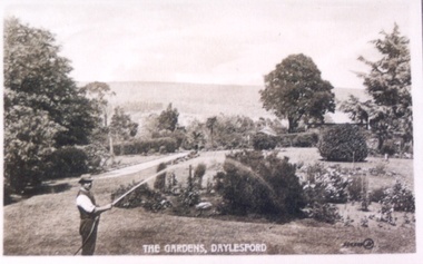
Photograph - Postcard, Wombat Hill Gardens, Daylesford
The Daylesford Botanic Gardens are of historic, scientific (botanic), and aesthetic significance to the State of Victoria. The Daylesford Botanic Gardens are historically significant as a fine example of a regional botanic garden demonstrating the typical characteristics of a carriage drive, informal park layout, decorative structures and works such as the memorial tower, conservatory, rotunda, cascade and fernery, which contrasts with the open lawns planted with specimen trees, areas of intensive horticultural interest and close proximity to a township developed during the mid to late nineteenth century. The Daylesford Botanic Gardens are historically significant for the design input by noted landscape designer William Sangster, and for the survival of his 1884 plan, which is a rare example of a plan from this prolific garden designer. The Daylesford Botanic Gardens are of scientific (botanic) significance for the extensive conifer collection and cool climate plants. The Gardens contain an outstanding collection of conifers and other mature trees, many of which were donated by renowned botanist Ferdinand von Mueller. Significant trees include Pinus ponderosa (Western Yellow Pine), Pinus coulteri (Big Cone Pine), twoAbies nordmanniana (Caucasian Fir), Abies pinsapo, (Spanish Fir) and a Cedrus atlantica f. glauca(Blue Atlas Cedar), Pinus wallichiana (Bhutan Pine), Pinus pinaster (Maritime Pine), Sequoiadendron giganteum (Giant Redwood), (Monkey Puzzle) and Aesculus hippocastanum (Horse Chestnut), many the largest or finest examples in Victoria. Other outstanding trees include a Tilia cordata (Small-leaved European Linden), a row of Cupressus lusitanica (Mexican cypress), a Quercus robur (English Oak) planted in 1863, avenues of Dutch Elms and a rare Quercus leucotrichophora (Himalayan Oak). The Daylesford Botanic Gardens are of aesthetic significance as a rare example of a botanic garden spectacularly sited on an extinct volcanic cone which allows a panoramic view, aided by the 1938 Pioneers’ Memorial Tower, as well as vistas within and out of the gardens and from the township to the gardens. As the most prominent local landmark, the Garden’s vertical dominance in the landscape provides a dark contrast to the elms avenues, oaks and other deciduous species. (Heritage Victoria Register, )Black and white postcard of Wombat Hill Botanical Gardens, Daylesford.wombat hill botanical gardens, daylesford, gardener, wombat hill botanic gardens -
 Ballarat Heritage Services
Photograph - Digital photographs, L.J. Gervasoni, Wombat Hill Botanic Gardens 150 anniversary event Daylesford community event, 2013
The Daylesford Botanic Gardens are of historic, scientific (botanic), and aesthetic significance to the State of Victoria. The Daylesford Botanic Gardens are historically significant as a fine example of a regional botanic garden demonstrating the typical characteristics of a carriage drive, informal park layout, decorative structures and works such as the memorial tower, conservatory, rotunda, cascade and fernery, which contrasts with the open lawns planted with specimen trees, areas of intensive horticultural interest and close proximity to a township developed during the mid to late nineteenth century. The Daylesford Botanic Gardens are historically significant for the design input by noted landscape designer William Sangster, and for the survival of his 1884 plan, which is a rare example of a plan from this prolific garden designer. The Daylesford Botanic Gardens are of scientific (botanic) significance for the extensive conifer collection and cool climate plants. The Gardens contain an outstanding collection of conifers and other mature trees, many of which were donated by renowned botanist Ferdinand von Mueller. Significant trees include Pinus ponderosa (Western Yellow Pine), Pinus coulteri (Big Cone Pine), twoAbies nordmanniana (Caucasian Fir), Abies pinsapo, (Spanish Fir) and a Cedrus atlantica f. glauca(Blue Atlas Cedar), Pinus wallichiana (Bhutan Pine), Pinus pinaster (Maritime Pine), Sequoiadendron giganteum (Giant Redwood), (Monkey Puzzle) and Aesculus hippocastanum (Horse Chestnut), many the largest or finest examples in Victoria. Other outstanding trees include a Tilia cordata (Small-leaved European Linden), a row of Cupressus lusitanica (Mexican cypress), a Quercus robur (English Oak) planted in 1863, avenues of Dutch Elms and a rare Quercus leucotrichophora (Himalayan Oak). The Daylesford Botanic Gardens are of aesthetic significance as a rare example of a botanic garden spectacularly sited on an extinct volcanic cone which allows a panoramic view, aided by the 1938 Pioneers’ Memorial Tower, as well as vistas within and out of the gardens and from the township to the gardens. As the most prominent local landmark, the Garden’s vertical dominance in the landscape provides a dark contrast to the elms avenues, oaks and other deciduous species. (Heritage Victoria Register, )Digital imagesvictoria, 150, anniversary, botanic, gardens, wombat hill, botanic gardens, heritage, celebration, garden party, daylesford, people, crowd, community, john hawker, john madigan, stilt, trees, owls, wombat hill botanic gardens -
 Ballarat Heritage Services
Photograph - digital photographs, Lisa Gervasoni, Wombat Hill, Daylesford, c2006-2016
The Daylesford Botanic Gardens are of historic, scientific (botanic), and aesthetic significance to the State of Victoria. The Daylesford Botanic Gardens are historically significant as a fine example of a regional botanic garden demonstrating the typical characteristics of a carriage drive, informal park layout, decorative structures and works such as the memorial tower, conservatory, rotunda, cascade and fernery, which contrasts with the open lawns planted with specimen trees, areas of intensive horticultural interest and close proximity to a township developed during the mid to late nineteenth century. The Daylesford Botanic Gardens are historically significant for the design input by noted landscape designer William Sangster, and for the survival of his 1884 plan, which is a rare example of a plan from this prolific garden designer. The Daylesford Botanic Gardens are of scientific (botanic) significance for the extensive conifer collection and cool climate plants. The Gardens contain an outstanding collection of conifers and other mature trees, many of which were donated by renowned botanist Ferdinand von Mueller. Significant trees include Pinus ponderosa (Western Yellow Pine), Pinus coulteri (Big Cone Pine), twoAbies nordmanniana (Caucasian Fir), Abies pinsapo, (Spanish Fir) and a Cedrus atlantica f. glauca(Blue Atlas Cedar), Pinus wallichiana (Bhutan Pine), Pinus pinaster (Maritime Pine), Sequoiadendron giganteum (Giant Redwood), (Monkey Puzzle) and Aesculus hippocastanum (Horse Chestnut), many the largest or finest examples in Victoria. Other outstanding trees include a Tilia cordata (Small-leaved European Linden), a row of Cupressus lusitanica (Mexican cypress), a Quercus robur (English Oak) planted in 1863, avenues of Dutch Elms and a rare Quercus leucotrichophora (Himalayan Oak). The Daylesford Botanic Gardens are of aesthetic significance as a rare example of a botanic garden spectacularly sited on an extinct volcanic cone which allows a panoramic view, aided by the 1938 Pioneers’ Memorial Tower, as well as vistas within and out of the gardens and from the township to the gardens. As the most prominent local landmark, the Garden’s vertical dominance in the landscape provides a dark contrast to the elms avenues, oaks and other deciduous species. (Heritage Victoria Register, )Colour photograph of Wombat Hill Botanical Gardens, Daylesford.heritage, daylesford, townscape, wombat hill, wombat hill botanical gardens, wombat hill botanic gardens -
 Ballarat Heritage Services
Photograph - Digital photographs, L.J. Gervasoni, Wombat Hill in the Fog, c2015
The Daylesford Botanic Gardens are of historic, scientific (botanic), and aesthetic significance to the State of Victoria. The Daylesford Botanic Gardens are historically significant as a fine example of a regional botanic garden demonstrating the typical characteristics of a carriage drive, informal park layout, decorative structures and works such as the memorial tower, conservatory, rotunda, cascade and fernery, which contrasts with the open lawns planted with specimen trees, areas of intensive horticultural interest and close proximity to a township developed during the mid to late nineteenth century. The Daylesford Botanic Gardens are historically significant for the design input by noted landscape designer William Sangster, and for the survival of his 1884 plan, which is a rare example of a plan from this prolific garden designer. The Daylesford Botanic Gardens are of scientific (botanic) significance for the extensive conifer collection and cool climate plants. The Gardens contain an outstanding collection of conifers and other mature trees, many of which were donated by renowned botanist Ferdinand von Mueller. Significant trees include Pinus ponderosa (Western Yellow Pine), Pinus coulteri (Big Cone Pine), twoAbies nordmanniana (Caucasian Fir), Abies pinsapo, (Spanish Fir) and a Cedrus atlantica f. glauca(Blue Atlas Cedar), Pinus wallichiana (Bhutan Pine), Pinus pinaster (Maritime Pine), Sequoiadendron giganteum (Giant Redwood), (Monkey Puzzle) and Aesculus hippocastanum (Horse Chestnut), many the largest or finest examples in Victoria. Other outstanding trees include a Tilia cordata (Small-leaved European Linden), a row of Cupressus lusitanica (Mexican cypress), a Quercus robur (English Oak) planted in 1863, avenues of Dutch Elms and a rare Quercus leucotrichophora (Himalayan Oak). The Daylesford Botanic Gardens are of aesthetic significance as a rare example of a botanic garden spectacularly sited on an extinct volcanic cone which allows a panoramic view, aided by the 1938 Pioneers’ Memorial Tower, as well as vistas within and out of the gardens and from the township to the gardens. As the most prominent local landmark, the Garden’s vertical dominance in the landscape provides a dark contrast to the elms avenues, oaks and other deciduous species. (Heritage Victoria Register, )Black and white photograph of a treed landscape covered with fog. The trees are in the Daylesford Botanical Gardens on Wombat Hill.wombat hill botanic gardens, wombat hill, daylesford, daylesford botanic gardens, fog, weather, arboretum -
 Ballarat Heritage Services
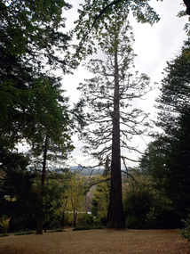
Photograph - Photograph - Colour, Clare Gervasoni, Wombat Botanic Gardens, Daylesford, 2019, 23/04/2019
The Daylesford Botanic Gardens are of historic, scientific (botanic), and aesthetic significance to the State of Victoria. The Daylesford Botanic Gardens are historically significant as a fine example of a regional botanic garden demonstrating the typical characteristics of a carriage drive, informal park layout, decorative structures and works such as the memorial tower, conservatory, rotunda, cascade and fernery, which contrasts with the open lawns planted with specimen trees, areas of intensive horticultural interest and close proximity to a township developed during the mid to late nineteenth century. The Daylesford Botanic Gardens are historically significant for the design input by noted landscape designer William Sangster, and for the survival of his 1884 plan, which is a rare example of a plan from this prolific garden designer. The Daylesford Botanic Gardens are of scientific (botanic) significance for the extensive conifer collection and cool climate plants. The Gardens contain an outstanding collection of conifers and other mature trees, many of which were donated by renowned botanist Ferdinand von Mueller. Significant trees include Pinus ponderosa (Western Yellow Pine), Pinus coulteri (Big Cone Pine), twoAbies nordmanniana (Caucasian Fir), Abies pinsapo, (Spanish Fir) and a Cedrus atlantica f. glauca(Blue Atlas Cedar), Pinus wallichiana (Bhutan Pine), Pinus pinaster (Maritime Pine), Sequoiadendron giganteum (Giant Redwood), (Monkey Puzzle) and Aesculus hippocastanum (Horse Chestnut), many the largest or finest examples in Victoria. Other outstanding trees include a Tilia cordata (Small-leaved European Linden), a row of Cupressus lusitanica (Mexican cypress), a Quercus robur (English Oak) planted in 1863, avenues of Dutch Elms and a rare Quercus leucotrichophora (Himalayan Oak). The Daylesford Botanic Gardens are of aesthetic significance as a rare example of a botanic garden spectacularly sited on an extinct volcanic cone which allows a panoramic view, aided by the 1938 Pioneers’ Memorial Tower, as well as vistas within and out of the gardens and from the township to the gardens. As the most prominent local landmark, the Garden’s vertical dominance in the landscape provides a dark contrast to the elms avenues, oaks and other deciduous species. (Heritage Victoria Register, )A tree in the Wombat Hill Gardens.wombat botanical gardens, daylesford botanical gardens, daylesford, trees, wombat hill botanic gardens -
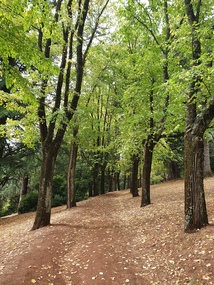 Ballarat Heritage Services
Photograph - Photograph - Colour, Clare Gervasoni, Wombat Botanic Gardens, Daylesford, 2019, 23/04/2019
The Daylesford Botanic Gardens are of historic, scientific (botanic), and aesthetic significance to the State of Victoria. The Daylesford Botanic Gardens are historically significant as a fine example of a regional botanic garden demonstrating the typical characteristics of a carriage drive, informal park layout, decorative structures and works such as the memorial tower, conservatory, rotunda, cascade and fernery, which contrasts with the open lawns planted with specimen trees, areas of intensive horticultural interest and close proximity to a township developed during the mid to late nineteenth century. The Daylesford Botanic Gardens are historically significant for the design input by noted landscape designer William Sangster, and for the survival of his 1884 plan, which is a rare example of a plan from this prolific garden designer. The Daylesford Botanic Gardens are of scientific (botanic) significance for the extensive conifer collection and cool climate plants. The Gardens contain an outstanding collection of conifers and other mature trees, many of which were donated by renowned botanist Ferdinand von Mueller. Significant trees include Pinus ponderosa (Western Yellow Pine), Pinus coulteri (Big Cone Pine), twoAbies nordmanniana (Caucasian Fir), Abies pinsapo, (Spanish Fir) and a Cedrus atlantica f. glauca(Blue Atlas Cedar), Pinus wallichiana (Bhutan Pine), Pinus pinaster (Maritime Pine), Sequoiadendron giganteum (Giant Redwood), (Monkey Puzzle) and Aesculus hippocastanum (Horse Chestnut), many the largest or finest examples in Victoria. Other outstanding trees include a Tilia cordata (Small-leaved European Linden), a row of Cupressus lusitanica (Mexican cypress), a Quercus robur (English Oak) planted in 1863, avenues of Dutch Elms and a rare Quercus leucotrichophora (Himalayan Oak). The Daylesford Botanic Gardens are of aesthetic significance as a rare example of a botanic garden spectacularly sited on an extinct volcanic cone which allows a panoramic view, aided by the 1938 Pioneers’ Memorial Tower, as well as vistas within and out of the gardens and from the township to the gardens. As the most prominent local landmark, the Garden’s vertical dominance in the landscape provides a dark contrast to the elms avenues, oaks and other deciduous species. (Heritage Victoria Register, 2025)An avenue of trees in the Wombat Hill Gardens. wombat botanical gardens, daylesford botanical gardens, daylesford, trees