Showing 392 items
matching department of lands and survey
-
 Bendigo Historical Society Inc.
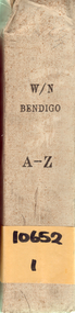
Document - DEPARTMENT OF LANDS AND SURVEY: WIRE NETTING ADVANCE REGISTER BENDIGO REGION
... DEPARTMENT OF LANDS AND SURVEY: WIRE NETTING ADVANCE...Department of Lands and Survey...Department of Lands and Survey Wire Netting Advance... ORGANISATION Government Department of Lands and Survey Department ...Department of Lands and Survey Wire Netting Advance register, Bendigo region. Large hard cover book with yellow card pages, representing individual properties in the Bendigo area. Written on spine of book: "W/Bendigo, A-Z, 10652,1" Dates in book from 1929 - 1939.organisation, government, department of lands and survey -
 Bendigo Historical Society Inc.
Map - PANNOOMILLOO : COUNTY OF BENDIGO, 1957
... and reproduced at the Department of Lands and Survey, Melbourne 1957... and reproduced at the Department of Lands and Survey, Melbourne 1957 ...Map. Pannoomilloo, County of Bendigo, Pannoobamawm, Milloo, Diggorra, Warragamba. Elmore Cohuna Railway. Waranga Mallee Channel. By authority W.M. Houston, Government Printer, Melbourne. Drawn and reproduced at the Department of Lands and Survey, Melbourne 1957. Price 2/-. (number 83 in map cupboard 1)W.M. Houston, Government Printer, Melbourne.map, bendigo, pannoomilloo -
Bendigo Historical Society Inc.
Map - NOLAN : COUNTY OF BENDIGO, 7-5-30
... , Government Printer, Melbourne. Drawn and reproduced at the Department... Printer, Melbourne. Drawn and reproduced at the Department ...Map. Nolan, County of Bendigo, Egerton, Elmore, Goornong, Campaspe River, Northern Railway. By Authority H.J. Green, Government Printer, Melbourne. Drawn and reproduced at the Department of Lands and Survey, Melbourne, Victoria.7-5-30. Price 2/-. (number 78 in map cupboard 1)H.J. Green, Government Printer, Melbourne.map, bendigo, nolan -
Bendigo Historical Society Inc.
Map - JANIEMBER WEST : COUNTY OF BENDIGO, September 1955
... at the Department of Lands and Survey, Melbourne. Price 2/-.September 1955..., Government Printer. Drawn and reproduced at the Department of Lands ...Map. Janiember West, County of Bendigo, Powlett, Janiember East, Jarklan, Kinypanial, River Loddon, Kelsh's Lagoon. By authority W.M. Houston, Government Printer. Drawn and reproduced at the Department of Lands and Survey, Melbourne. Price 2/-.September 1955. (number 64 in map cupboard 1)W.M. Houston, Government Printermap, bendigo, janiember west -
Bendigo Historical Society Inc.
Map - PARISH OF SHELBOURNE : COUNTY OF BENDIGO, 11-12-15
... . Photographed at the Department of Lands and Survey, Melbourne.... Photographed at the Department of Lands and Survey, Melbourne ...Map. Parish of Shelbourne, County of Bendigo, Marong, Lockwood, Ravenswood, Bradford, Laanecoorie, Woodstock. Photographed at the Department of Lands and Survey, Melbourne by W.J.Butson, 11-12-15. Price 1/-. By authority Albert J. Mullett, Government Printer, Melbourne. (number 32 in map cupboard 1)Albert J. Mullett, Government Printer, Melbourne.map, bendigo, shelbourne -
Bendigo Historical Society Inc.
Map - EGERTON : COUNTY OF BENDIGO, 1-3-30
... at the Department of Lands and Survey, Melbourne. Price 2/-. 1-3-30.... Photo-Lithographed at the Department of Lands and Survey ...Map. Egerton, County of Bendigo, Minto, Diggorra, Elmore, Nolan, Goornong, Bagshot, Whirrakee. Bendigo Creek. By authority J.J. Green, Govt. Printer. Photo-Lithographed at the Department of Lands and Survey, Melbourne. Price 2/-. 1-3-30. (number 47 in map cupboard 1)J.J. Green, Govt. Printer.map, bendigo, egerton -
Bendigo Historical Society Inc.
Map - REDCASTLE : COUNTY OF BENDIGO, 10-8-08
... at the Department. of Lands and Survey, Melbourne by T.F. McGaraun 10-8-08.... Photo-Lithographed at the Department. of Lands and Survey ...Map. Redcastle, County of Bendigo, County of Rodney, Cornella, Cherrington, Dargile, Crosbie, Cornella Creek, Redcastle Creek, Mount Camel, Township of Redcastle. Photo-Lithographed at the Department. of Lands and Survey, Melbourne by T.F. McGaraun 10-8-08. (number 109 in map cupboard 1)T.F. McGaraunmap, bendigo, redcastle -
Bendigo Historical Society Inc.
Map - HAWKESTONE : COUNTY OF BENDIGO, December 1953
... and reproduced at the Department of Lands and Survey, Melbourne. December... at the Department of Lands and Survey, Melbourne. December 1953. Price 5 ...Map. Hawkestone, County of Bendigo, County of Talbot, Sutton Grange, Redesdale, Faraday, Elphinstone, Metcalfe, Coliban River. By authority W.M. Houston, Government Printer. Drawn and reproduced at the Department of Lands and Survey, Melbourne. December 1953. Price 5/-. (number 97 in map cupboard 1)W.M. Houston, Government Printer.map, bendigo, hawkestone. -
Clunes Museum
Document (Item), DEPT. OF LANDS AND SURVEY, RENEWALS GARDEN LICENCE 5/, 1890-1892
... DEPARTMENT OF LANDS AND SURVEY...RECEIPT BOOK - DEPARTMENT OF LANDS AND SURVEY LICENCE... BOOK - DEPARTMENT OF LANDS AND SURVEY LICENCE TO ENTER UPON ...RECEIPT BOOK - DEPARTMENT OF LANDS AND SURVEY LICENCE TO ENTER UPON CROWN LANDS NOT EXCEEDING IN AREA ONE ACRE AS SPECIFIED HEREUNDER FOR PURPOSE OF GARDEN AND RESIDENCE.NILlocal history, licence, garden, department of lands and survey -
Clunes Museum
Administrative record - BOOK, GARDEN LICENCE 5/
... RECEIPT BOOK. DEPARTMENT OF LANDS AND SURVEY. LICENCE... BOOK. DEPARTMENT OF LANDS AND SURVEY. LICENCE TO ENTER UPON ...RECEIPT BOOK. DEPARTMENT OF LANDS AND SURVEY. LICENCE TO ENTER UPON CROWN LANDS NOT EXCEEDING IN AREA ONE ACRE AS SPECIFIED, HEREUNDER FOR PURPOSE OF GARDEN AND RESIDENCE.BLUE COVERED RECEIPT BOOK CONTAINING PAYMENTS FOR GARDEN LICENCE NOd 188181 TO 188200 DATED MARCH 1885 TO NOVEMBER 1885local history, local gov., council, licence, garden -
Bendigo Historical Society Inc.
Map - JANIEMBER WEST : COUNTY OF BENDIGO, September 1955
... and reproduced at the Department of Lands and Survey, Melbourne... and reproduced at the Department of Lands and Survey, Melbourne ...Map. Janiember West, County of Bendigo. Loddon River, Janiember East, Powlett, Kinypanial, Jarklan. Welsh's Lagoon. By authority W.M. Houston, Government Printer, Melbourne. Drawn and reproduced at the Department of Lands and Survey, Melbourne, September 1955, Price 5/-. (number 66 in map cupboard 1)W.M. Houston, Government Printer, Melbourne.map, bendigo, janiember west -
Bendigo Historical Society Inc.
Map - KAMAROOKA : COUNTY OF BENDIGO, 29-8-21
... at the Department of Lands and Survey, Melbourne by W.J. Butson 29-8-21.... Photo-Lithographed at the Department of Lands and Survey ...Map. Kamarooka, County of Bendigo, Milloo, Warragamba, Minto, Whirrakee, Tandarra, Piccaninny Creek, Dingee. By authority A.J. Mullett, Govt. Printer. Photo-Lithographed at the Department of Lands and Survey, Melbourne by W.J. Butson 29-8-21. Price 1/-. (number 63 in map cupboard 1)A.J. Mullett, Govt.Printermap, bendigo, kamarooka -
Bendigo Historical Society Inc.
Map - TARNAGULLA : COUNTY OF BENDIGO, 1959
... and reproduced at the Department of Lands and Survey, Melbourne, 1959... at the Department of Lands and Survey, Melbourne, 1959. Price 5/- per sheet ...Map. Tarnagulla, County of Bendigo, Sheet 3, Kingower, Glenalbyn, Inglewood, Loddon River, Derby, Gladstone. Drawn and reproduced at the Department of Lands and Survey, Melbourne, 1959. Price 5/- per sheet. By authority A.C. Brooks, Government Printer, Melbourne. (number 35 in map cupboard 1)A.C. Brooks Government Printer, Melbourne.map, bendigo, tarnagulla -
Bendigo Historical Society Inc.
Map - CORNELLA : COUNTY OF BENDIGO, 13-4-32
... -Lithographed at the Department of Lands and Survey, Melbourne. 13-4-32..., Govt. Printer. Photo-Lithographed at the Department of Lands ...Map. Cornella, County of Bendigo, County of Rodney, Colbinabbin, Gobarup, Redcastle, Toolleen, Kangaroo Creek, Cornella Creek. By authority H.J. Green, Govt. Printer. Photo-Lithographed at the Department of Lands and Survey, Melbourne. 13-4-32. Price 2/-. (number 123 in map cupboard 1)H.J. Green, Govt.Printermap, bendigo, cornella -
Bendigo Historical Society Inc.
Map - BRIDGEWATER : COUNTY OF BENDIGO, 6-10-27
... at the Department of Lands and Survey Melbourne by W.J. Butson, 6-10-27... Railway. Photo-Lithographed at the Department of Lands and Survey ...Map. Bridgewater, County of Bendigo, Inglewood, Salisbury, Derby, Leichardt, Yarraberb, Yarrayne, Bullock Creek, Loddon River, Sandhurst and Inglewood Railway. Photo-Lithographed at the Department of Lands and Survey Melbourne by W.J. Butson, 6-10-27. Price 1/-. (number 53 in map cupboard 1)W.J. Butsonmap, bendigo, bridgewater -
Bendigo Historical Society Inc.
Map - BAMAWM : COUNTY OF BENDIGO, November 1954
... at the Department of Lands and Survey, Melbourne. November 1954. Price 5.... Houston, Government Printer.Drawn and reproduced at the Department ...Map. Bamawm, County of Bendigo. Sheet 2, Pannoobamawm, Diggorra. Elmore to Cohuna Railway Line. Township of Lockington. By authority W.M. Houston, Government Printer.Drawn and reproduced at the Department of Lands and Survey, Melbourne. November 1954. Price 5/- per sheet. (number 52 in map cupboard 1)W.M. Houston, Government Printermap, bendigo, bamawm -
Bendigo Historical Society Inc.
Map - YARRABERB : COUNTY OF BENDIGO, 23-2-15
... at the Department of Lands and Survey, Melbourne by W.J. Butson 23-2-15.... Photographed at the Department of Lands and Survey, Melbourne by W.J ...Map. Yarraberb, County of Bendigo, Salisbury, Yallook, Neilborough, Nerring, Leichardt, Bridgewater. L5373. Photographed at the Department of Lands and Survey, Melbourne by W.J. Butson 23-2-15. Price 1/-.By authority: Albert J. Mullett, Government Printer, Melbourne. (number 16 in map cupboard 1)By authority Albert J. Mullett, Government Printer.map, bendigo, agricultural lands -
Bendigo Historical Society Inc.
Map - YALLOOK : COUNTY OF BENDIGO, 1957
... at the Department of Lands and Survey, Melbourne,1957. Distances shown... at the Department of Lands and Survey, Melbourne,1957. Distances shown ...Map. Yallook, County of Bendigo, Talambe, Neilborough, Yarraberb, Salisbury, Pompapiel. Drawn and reproduced at the Department of Lands and Survey, Melbourne,1957. Distances shown on the plan are derived from original surveys of varying dates and whilst approximately correct do not necessarily conform to modern standards of accuracy. For survey information application should be made to the central plan office, or to the office of titles. Some ink scibbles appear at the right top of this map. Price 2/-. (number 14 in map cupboard 1)By Authority W.M.Houston, Govt.Printer,Melbourne.map, bendigo, yallook -
Bendigo Historical Society Inc.
Map - KIMBOLTON : COUNTY OF BENDIGO, 1966
... , Government Printer, Melbourne. Drawn and reproduced at the Department..., Melbourne. Drawn and reproduced at the Department of Lands ...Map. Kimbolton, County of Bendigo. Eppalock, Lyell, Knowsley, Langwornor, Redesdale, County of Dalhouse, County of Rodney, Campaspe River, Coliban River,By authority A.C.Brooks, Government Printer, Melbourne. Drawn and reproduced at the Department of Lands and Survey, Melbourne, 1966, Price $1.00 (number 65 in map cupboard 1)A.C. Brooks, Government Printer, Melbourne.map, bendigo, kimbolton -
Bendigo Historical Society Inc.
Map - MAP: BENDIGO SHEET 2, 1910, 1910
... of map taken for research purposes. Map prepared by Department... purposes. Map prepared by Department of Lands and Survey, Melbourne ...Map. Map with timber ends, showing names of property owners. Bendigo from Olinda Street west to Prouses Road and Bennet / Wattle Street to Dooley Street in the north. Copy of map taken for research purposes. Map prepared by Department of Lands and Survey, Melbourne by T.F. McGauran 4.1.10 ( 1910 )map, bendigo, bendigo, residence, residence areas, 1910, map -
Bendigo Historical Society Inc.
Map - TANDARRA : COUNTY OF BENDIGO, 14-3-24
... at the Department of Lands and Survey, Melbourne by W.J. Butson,14-3-24... at the Department of Lands and Survey, Melbourne by W.J. Butson,14-3-24 ...Map. Tandarra, County of Bendigo, Talambe, Yallook, Neilborough, Whirrakee, Kamarooka. Photo-Lithographed at the Department of Lands and Survey, Melbourne by W.J. Butson,14-3-24. Price 1/-.Myers Creek, Tandarra Estate. By authority Mullett, Government Printer, Melbourne. (number 24 in map cupboard 1)Albert J. Mullett, Government Printer, Melbourne.map, bendigo, tandarra -
Bendigo Historical Society Inc.
Map - CAMPBELL COLLECTION: BENDIGO AND DISTRICT MAPS, June 1953
... . Drawn and reproduced at the Department of Lands and Survey... and reproduced at the Department of Lands and Survey, Melbourne, Victoria ...Map. Marong, County of Bendigo, Scale 40 chains to 1 inch. Woodstock, Leichardt, Nerring, Sandhurst, Lockwood, Shelbourne. Drawn and reproduced at the Department of Lands and Survey, Melbourne, Victoria. By Authority : W.M. Houston, Government Printer. June 1953. Price 2/-. (number 403 in map cupboard 1)W.M. Houston, Government Printer.map, bendigo, agricultural lands -
Bendigo Historical Society Inc.
Map - BAGSHOT : COUNTY OF BENDIGO, November 1948
... and reproduced at the Department of Lands and Survey, Melbourne, Victoria... at the Department of Lands and Survey, Melbourne, Victoria. November 1948 ...Map. Bagshot. County of Bendigo, Huntly, Whirrakee, Egerton, Goornong, Ellesmere, Wellsford. Reedy Creek, Sandy Creek. Drawn and reproduced at the Department of Lands and Survey, Melbourne, Victoria. November 1948, Price 2/-. By authority J.J. Gourley, Government Printer, Melbourne. (number 46 in map cupboard 1)J.J. Gourley, Government Printer, Melbourne.map, bendigo, bagshot -
Bendigo Historical Society Inc.
Map - GOORNONG : COUNTY OF BENDIGO, September 1943
... . Drawn and reproduced at the Department of Lands and Survey... at the Department of Lands and Survey, Melbourne, Victoria. September 1943 ...Map. Goornong, County of Bendigo, Egerton, Bagshot, Ellesmere, Muskerry, Campaspe, Nolan, Campaspe River, Town of Goornong. By authority : H.E. Daw, Government Printer, Melbourne. Drawn and reproduced at the Department of Lands and Survey, Melbourne, Victoria. September 1943, Price 2/-. (number 44 in map cupboard 1)H.E. Daw, Government Printer, Melbourne.map, bendigo, goornong -
Bendigo Historical Society Inc.
Map - CROSBIE : COUNTY OF BENDIGO, 28-9-76
... at the Department of Lands and Survey, Melbourne, J. Noune,28-9-76. (number... 1878. Photo-Lithographed at the Department of Lands and Survey ...Map. Crosbie, County of Bendigo, County of Rodney, Mt. Pleasant Creek, Weston, Toolleen, Redcastle, Dargile, Knowsley East. W.E. Porter, draughtsman, August 1878. Photo-Lithographed at the Department of Lands and Survey, Melbourne, J. Noune,28-9-76. (number 113 in map cupboard 1)W.E. Porter, Draughtsmanmap, bendigo, crosbie -
Bendigo Historical Society Inc.
Map - CAMPBELL COLLECTION: BENDIGO AND DISTRICT MAPS, March 1947
... chains to 1 inch. Drawn and reproduced at the Department of Lands.... Drawn and reproduced at the Department of Lands and Survey ...Map. Mandurang, County of Bendigo, Sandhurst, Strathfieldsaye, Sedgwick, Sutton Grange, Ravenswood, Lockwood. Scale 40 chains to 1 inch. Drawn and reproduced at the Department of Lands and Survey, Melbourne, March 1947, price 2/-. By Authority : J.J. Gourley, Government Printer, Melbourne. (number 402 in map cupboard 1)J.J. Gourley, Government Printer.map, bendigo, allotments -
Bendigo Historical Society Inc.
Map - CAMPBELL COLLECTION: BENDIGO AND DISTRICT MAPS, August 1952
... . Drawn and reproduced at the Department of Lands and Survey... at the Department of Lands and Survey, Melbourne, Victoria, August 1952 ...Map. Nerring, County of Bendigo, Yarraberb, Neilborough, Leichardt, Marong, Sandhurst, Huntly. Scale 20 chains to 1 inch. Drawn and reproduced at the Department of Lands and Survey, Melbourne, Victoria, August 1952. Price 2/-. By Authority J.J. Gourley, Government Printer, Melbourne. (number 404 in map cupboard 1)J.J. Gourley, Government Printermap, bendigo, allotments -
Bendigo Historical Society Inc.
Map - CAMPBELL COLLECTION: BENDIGO AND DISTRICT MAPS, 1963
... . Drawn and reproduced at the Department of Lands and Survey.... Drawn and reproduced at the Department of Lands and Survey ...Map. Sedgwick, County of Bendigo. Scale 20 chains to 1 inch. Strathfieldsaye, Eppalock, Lyell, Mandurang, Sutton Grange, County of Talbot. By Authority A.C. Brooks,Government Printer, Melbourne. Drawn and reproduced at the Department of Lands and Survey, Melbourne.1963. Price 2/-. (number 405 in map cupboard 1)A.C. Brooks, Governmenr Printer, Melbourne.map, bendigo, allotments -
Bendigo Historical Society Inc.
Map - WOODSTOCK : COUNTY OF BENDIGO, 4-7-35
... and Laanecoorie Railway. Drawn and reproduced at the Department of Lands... Railway. Drawn and reproduced at the Department of Lands ...Map. Woodstock, County of Bendigo, Derby, Leichardt, Marong, Shelbourne, Laanecoorie, Tarnagulla. Bradford Creek, Maldon and Laanecoorie Railway. Drawn and reproduced at the Department of Lands and Survey, Melbourne, Victoria.4-7-35. Price 2/-. By authority H.J. Green,Govt. Printer. (number 41 in map cupboard 1)H.J. Green, Govt. Printer.map, bendigo, woodstock -
Bendigo Historical Society Inc.
Map - RUNNYMEDE : COUNTY OF BENDIGO, 8-12-13
... at the Department of Lands and Survey, Melbourne by W.J. Butson.8-12-13... Pleasant Creek. Photo-Lithographed at the Department of Lands ...Map. County of Bendigo, County of Rodney, Burnewang, Elmore, Nolan, Campaspe, Colbinabbin, Burramboot, Corop, Township of Runnymede, Campaspe River, Mount Pleasant Creek. Photo-Lithographed at the Department of Lands and Survey, Melbourne by W.J. Butson.8-12-13. Price 1/-. (number 107 in map cupboard 1)W.J. Butsonmap, bendigo, runnymede