Showing 191 items
matching eaglehawk road bendigo
-
 Melbourne Tram Museum
Document - Personal Papers, H. S McComb, "Gazette", 1920's
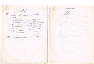
Set of quarto hand written sheet pinned together for each year with some typed sheets, listing notices in the Victorian Government Gazette of non-Melbourne suburban tramways - timber tramways, proposed lines. Items for 1898 and 1898 - carbon copies. 1885 - Ballarat and the Grand Fern Tree Gully Hotel 1886 - Ballarat, Coburg, Moorabbin and Ballarat 1887 - Beaumaris, Koondrook, Swan Hill, Sorento, Eaglehawk, Sandhurst (Bendigo) Ballarat, Yarrawonga, Warragul, Coburg 1888 - Ballarat, Eaglehawk, Geelong, Coburg, Moorabbin, Caulfield, Northcote 1889 - Ballarat, Bullen, Boroondara, Nunawading, Northcote 1890 - Moorabbin, Caulfield, Traralgon, Oakleigh 1898 - Northcote, 1899 - Northcotetrams, tramways, tramways, government gazette, ballarat, coburg, moorabbin, bendigo, geelong, northcote -
 Melbourne Tram Museum
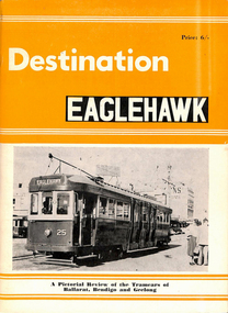
Book, Compiled by K.S.Kings, Edited J.Richardson, "Destination Eaglehawk", 1965
Book, 48 pages, "Destination Eaglehawk", with orange colour card covers, printed, with photographs, brief review of history of Ballarat, Bendigo and Geelong SECV Tramcars with some notes on the tramway systems themselves. No maps. Published by Traction Publications Canberra 1965, dedicated to Wal Jack.trams, tramways, secv, ballarat, bendigo, geelong -
 Melbourne Tram Museum
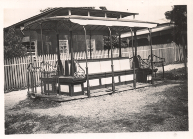
Photograph - Old cable tram dummy - Eaglehawk, Ken Train, 9/2/1941
Photograph shows a former Melbourne cable tram dummy or grip car placed on the ground without its wheels and in use as a shelter, near the Eaglehawk tram terminus, Feb. 1941. Photo by Ken Train.Demonstrates the use of former Melbourne cable tram dummy or grip cars as a low cost shelter.Photograph - black and white with typed notes on rear.9/2 4I. Old cable tram dummy, near Eaglehawk tram terminus, Bendigo." Ken Magor stamp with "per K Train".cable trams, grip car, dummy, shelters, eaglehawk, bendigo -
 Melbourne Tram Museum
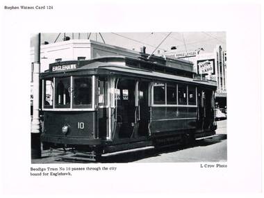
Photograph - Illustration/s, Stephen Watson, c1960
Printed illustration on light weight card, of Bendigo No. 10. Printed by Stephen Watson, as Card No. 124. Photo by L. Crow. Photo taken late 1950's or early 1960 prior to the application of dash canopy lighting and warning stripes. Photo in Mitchell St. Bendigo, with an advertisement for Astor Radio in the background. Tram has the destination of Eaglehawk..trams, tramways, bendigo, tram 10 -
 Melbourne Tram Museum
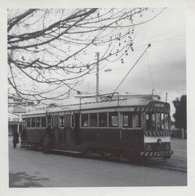
Photograph - Black & White Photograph/s, late 1960's
Black and white photograph of Bendigo No. 3 at the Eaglehawk terminus late 1960's or early 1970's. Has passengers boarding the tram. The tram has the destination of Quarry Hill.On rear in pencil "Max Tract Ex Geelong, Ex MMTB ex Hawthorn TT"trams, tramways, maximum traction, secv, bendigo, tram 3 -
 Bendigo Historical Society Inc.
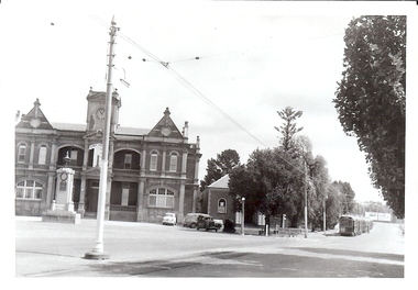
Photograph - BASIL MILLER COLLECTION: TRAMS - EAGLEHAWK
Black and white photo showing trams on Sailors Gully Road, Eaglehawk. Eaglehawk Town Hall and War Memorial on left, and 3 Bogie trams on right. Number 'C922' stamped on the back of photo.basil miller, bendigo trams -
 Bendigo Historical Society Inc.
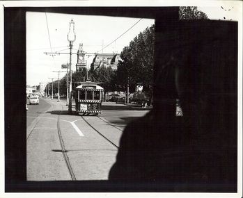
Photograph - BASIL MILLER COLLECTION: NUMBER 7 TRAM
Black and white photograph taken while on board tram, of another tram heading up Pall Mall, destined for North Bendigo line. Post Office, Law Courts and City Family Hotel are all visible ion the background. Stamped in black on the back of photo: Photograph by Claver P. Carroll 79 Eaglehawk Road Eaglehawk. No. TR25. There are two copies of this photo.Claver P. Carrollbasil miller, bendigo trams -
 Bendigo Historical Society Inc.
Document - Hustlers, Sheepshead and Deborah lines of reef
Albert Richardson was a mining historian who wrote widely on the mines of the Bendigo Goldfield. The park opposite the Goldmines Hotel in Marong Road, is named in his honour. Five page document, hand written by Albert Richardson on lined foolscap and edited with cross-outs and insertions, . The mines along the Hustlers line of reef and the Sheepshead line of reef are described. Mines listed on Hustlers line of reef: Fortuna Hustlers (1888 - 1913), shaft 2,240 feet at rear of Buckell and Jeffrey's offices; Royal Hustlers Reserve No. 2 - two shafts 'City" 860 feet, now covered by R.S.L. building Pall Mall, steel poppet legs 60 ft high and 'Park Shaft" at rear of Camp Hill School, 1,775 feet, steel poppet legs 60 feet high; Hustlers Hill Group first worked by Jonathan Harris in 1853 and bounded by Valentine, Anderson and Ironbark Creek to the north and Milroy Street to the east, one of first areas worked for quartz reefing. It with Garden Gully line west and Victoria Hill Ironbark, formed by far the richest cross section of the Bendigo Goldfield. Great Extended Hustlers (1865-1921) close to intersection of Anderson Street and Hustlers Road, mullock heap against road and shored up around shaft, steel poppet legs now at Wattle Gully mine, Chewton, large winding machine, air compressor south of shaft and 36 head crushing battery. Hustlers Reef (Old Hustlers) and Hustlers Reef No. 1, two shafts, main 2,210 feet, about 220 yards east of Moran Street and against Fenton Street. , No. 1 shaft 1,140 feet and about 155 yards east of Moran Street. Lansell's Comet, Lightining Hill line, 2.100 feet, on Comet Hill approx 70 yards west of Holmes Road, near Comet Creek, steel poppet legs. United Hustlers and Redan (1876-1918), main Redan, 1,830 feet about 155 yards west of Sandhurst Roead, in line with Comet Hill State School, this hill known as Redan Hill. North, or New Hustlers, once known as Agnew Hustlers, wooden poppet legs, south side, Kneebone Street, Eaglehawk. Derby line, Johnson's No. 3, South Johnson's (east shaft of Collman and Tacchi) 439 feet on west wide of Woods Street, south of Wetherall Street. Paddy's Gully Line, south to north, some shafts - Lansell's 'Sandhurst" ('Needle") Eaglehawk Road shaft 2,425 feet, about 50 yards east of Needle Loops, a brick square sided chimney with Cleopatra Needle top. British American, 789 feet, just south of Holdsworth Road. Collman and Tacchi, main shaft 2,588 feet, 60 yards west of Eaglehawk Road, California Gully. Deborah Line of Reef, The Deborah (1932-1954) shaft 2.017 feet, west of Adams Road and south of Abel Street, Quarry Hill. North Deborah (1937 - 1954) shaft 1,151 feet, Breen Street, Quarry Hill, steel poppet legs. Central Deborah (1939-1954) shaft 1,347 feet Sheepshead line of reef, Lansell's South Red, White and Blue, shaft 2,124 feet, north east of Bellevue Road and 220 yards east of Adams Road. The New Red, White and Blue Consolidated (Big Blue) main shaft 2,416 feet. Lansell's Bendigo Battery 105 head, north of 'Big Blue" on his freehold lease, commenced crushing on 24th February 1895. After closing was erected as the Showground's Industrial Hall, July 1926. North Red, White and Blue, burnt down February 1926, new company 1934, closed 1938. Document is part of the Albert Richardson Collection of Bendigo mining history. bendigo, gold mining, deborah line of reef, sheepshead line of reef, hustlers line of reef, royal hustlers reserve mine, hustlers hill group of mines, great extended hustlers, hustlers reef no. 1, lightning hill line, old comet, collman and tacchi, lansell's comet, north deborah, central deborah, dhrrpdhrsf linr og trrg, new red, white and blue consolidated mine, big blue, lansell's bendigo battery, north red, white and blue mine, albert richardson collection -
 City of Greater Bendigo - Civic Collection
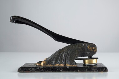
Ceremonial object - Common Seal, Rural City of Marong et al
The first local government authority for Marong was the Marong Road District (an early form of single-purpose local government), which was proclaimed on 19 August 1860. Its boundary was altered twice in 1862 and on 12 December 1864 it was re designated as a Shire. It absorbed Raywood Borough in 1915, and was proclaimed a Rural City in 1990. On 2 December 1994, with the creation of Greater Bendigo City Council, it was abolished through the amalgamation which took place between Bendigo City, Eaglehawk Borough, Huntly Shire, part of McIvor Shire, part of Metcalfe Shire and Strathfieldsaye Shire to form the City of Greater Bendigo. This embosser would have been used over the years by the local council authority. Decorated hand operated cast iron embosser with 50mm stamp head attached. Gold painted decorations on body of embosser only. Lever is also cast iron. Well used showing all over signs of wear. Stamp is for the Rural City of MarongRural / City / of / Marong -
 Bendigo Historical Society Inc.
Map - WALL MAP
Paper on canvas wall map. Street and Road map of City of Greater Bendigo, Borough of Eaglehawk and Surrounding Districts. Wooden hanging rod on top edge. Plastic rod on lower edge. Light brown background. Tw hanging tapes at centre of top hanging rod. Printed in black and red. Includes Street indexes, historical information and key to points of interest.eaglehawk, map -
 Bendigo Historical Society Inc.
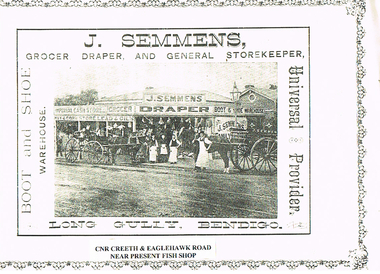
Photograph - LONG GULLY HISTORY GROUP COLLECTION: J SEMMENS GENERAL STORE
BHS CollectionPhotocopy of a photo of J Semmens General Store, Long Gully, Bendigo. Under the photo is printed on white paper Cnr Creeth & Eaglehawk Road near present Fish Shop. The photo shows the store with the name J Semmens Draper, Grocer, Imperial Cash Store, Hay & Corn Store, Lead & Oils, Boot & Shoe Warehouse. In front of the store is a cart with the name on it with an employee standing at the horse's shoulder, three other employees in front of the store and a horse and buggy with someone sitting in the buggy. Various items are hanging from the edge of the veranda. There is a printed border around three sides of the page.bendigo, history, long gully history group, the long gully history group - j semmens general store