Showing 213 items
matching eastern view
-
 Melbourne Tram Museum
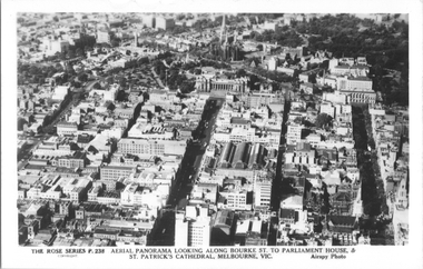
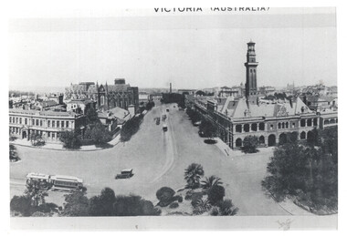
Postcard, Rose Stereograph Co, "Aerial Panorama looking along Bourke St.", mid 1940s
Rose Series postcard No. P 238, titled "Aerial Panorama looking along Bourke St. to Parliament House & St Patrick's Cathedral, Melbourne - Airspy photo" - There are buses in Bourke Street. Note the three large roof spans of the Eastern Market in the middle of the photo. Photo dated around mid-1940s.Yields information about east end of both Bourke and Collins Streets in the mid 1940s.Postcard - printed real photograph with Rose Stereograph Co. name on the rear.aerial views, melbourne, bourke st, collins st, eastern market -
 Melbourne Tram Museum
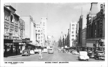
Postcard, Rose Stereograph Co, "Bourke St, Melbourne", late 1940s
Rose Series postcard No. P 2745, titled "Bourke St, Melbourne". Photo taken from between Exhibition and Russell Streets looking west, with two double deck buses and one single deck bus in the view. The cable tram track remains in position. Photo late 1940s.Yields information about the eastern end of Bourke St in the late 1940s.Postcard - printed real photograph with Rose Stereograph Co. name on the rear.tramways, trams, bourke st, buses, mmtb buses -
 Melbourne Tram Museum
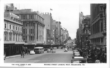
Postcard, Rose Stereograph Co, "Bourke Street Looking West, Melbourne", late 1940s
Rose Series postcard No. P 4693, titled "Bourke Street Looking West, Melbourne". Photo taken from the north side of Bourke St between Swanston St and Russell St. Has a number of double decker and single deck buses in the view. A W2 class tram is waiting on the south side of Bourke Street in Swanston Street. Photo late 1940s. The former cable tram tracks remain in the street. the Foys Department store is on the right. Yields information about the eastern end of Bourke St in the late 1940s.Postcard - printed real photograph with Rose Stereograph Co. name on the rear.tramways, trams, bourke st, buses, mmtb buses, leyland, td5c class, w2 class, swanston st -
 Melbourne Tram Museum
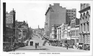
Postcard, Rose Stereograph Co, "Lonsdale Street Melbourne', c1933
Rose Series postcard No. P 3645, titled "Lonsdale Street Melbourne', looking east from Queen Street. Has several cable trams in the far distance at Swanston Street. In the view is the Myer Emporium Lonsdale Street store and the Eastern Hill fire station tower. There are adverts for Dulux, Tribune, Wynss, Fox films, A E Hoad? Stillwell Stephens. The cable trams in Lonsdale Street west of Elizabeth Street closed in early 1935 and the remainder in 1939. Yields information about Lonsdale St c1933.Postcard - printed real photograph with Rose Stereograph Co. name on the rear.Has the 3rd part of a letter to Ken on the rear.trams, tramways, cable trams, lonsdale st, myer -
 Melbourne Tram Museum
Postcard, "A Glimpse of Collins St Melbourne Victoria", mid 1900's?
Image of Collins St looking west from Russell St with two cable trams in the view. Includes the Town Hall. Printed mid-1900's. Titled "A Glimpse of Collins St Melbourne Victoria". On the rear is a handwritten message and address - the removal of the stamp has obscured name. No printer details other than a number "B135/841" and in the bottom right hand corner "No. 8". Second copy in good order.Yields information about Collins St eastern end.Divided back postcard featuring a coloured image - Two copies held.trams, tramways, collins st, cable trams, town hall -
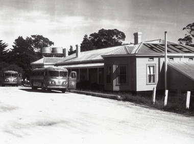 Lakes Entrance Historical Society
Photograph - Kalimna Hotel, 1960c
This is the before paired photograph used in the 150 year, Lakes Entrance 1858-2008 display.|The after paired photograph number is 01335.1|Also one 12 x 16 framed photograph used in room display.| The hotel was owned by Ansett and used by their coaches for a meal stop-off point. The Kalimna is often referred to as the Hotel with a View.Black and white enlarged photograph showing original Kalimna Hotel prior to a fire in 1962 which burnt the old bar on the Eastern end of the hotel. Dirt road at front with two Ansett buses and people in front of hotel. Two water tanks, three chimneys and hotel painted on top of roof. Lakes Entrance Victoria,restaurant, hotels, room display -
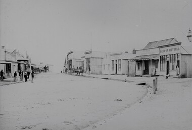 Stawell Historical Society Inc
Photograph, Upper Main Street with the London Chartered Bank on the right, Mr W Muir Produce Dealer & the Bank of Victoria 1866
Main Street. On Right is London Chartered Bank. W Muir Produce Dealer. Bank of Victoria. Part of a collection of Photographs by Mr. O.G. Armstrong as commissioned by the Shire of Stawell for the Inter-colonial and Paris Exhibition in Melbourne in 1866. Another view of the top or eastern end of Main Street 1866. It is almost the same area as in photo No 14 but looking westward towards the Grampians. Streetscape with bend of road in foreground. Bank of Victoria prominent on right side of image.stawell businesses streetscape -
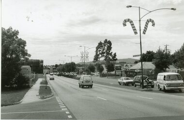 Ringwood and District Historical Society
Photograph, Ringwood black and white photographs
Black and white photographMaroondah Hwy. view East from bonview Ave near proposed site of Eastern Ring Road -
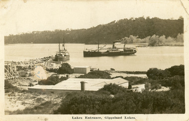 Lakes Entrance Historical Society
Postcard - SS Wyrallah, SS Manawatu, c1910
Sepia toned postcard showing view of New Works buildings at north end of eastern pier. Cunninghame Arm in front of buildings, Reeves River left in distance. SS Wyrallah steaming past, and SS Manawatu at pier. Jemmy's Point, Mt Barkly, and Kalimna hills in background. Photo taken from top of dune. Smoke issuing from SS Wyrallah funnel. Carstairs boarding house in centre foreground. Lakes Entrance VictoriaLakes Entrance - Gippsland Lakes ships and shipping, piers, historic site -
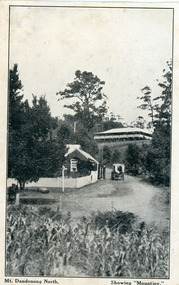 Mt Dandenong & District Historical Society Inc.
Photograph, Mt Dandenong North. Showing "Mountjoy"
... . There were commanding views of the eastern ranges and the city.... There were commanding views of the eastern ranges and the city ...The building with the white picket fence is the Beulah Tea Gardens opened by Eliza Hand c1904 at The Gap (now FiveWays). The building is still operating as a cafe. The Tourist Road does not yet exist. Old Coach Road comes into the picture from the right and the horse and cart is heading up Ridge Road. The elm trees can be seen on the left. The building up on the hill is the Mountjoy Guest House. ‘Mountjoy’ was built by the Paynter family in 1905. It had fourteen bedrooms, a dining room and sitting room, kitchen with a big wood burning range and verandahs on three sides. There were commanding views of the eastern ranges and the city to the west. Ellis Jeeves purchased ‘Mountjoy’ in 1908 and it soon became a popular tourist destination, the coach yards making it a centre of the district. ‘Mountjoy’ is a central feature of many photographs of Kalorama in the 1900s. The building burned down in 1975. Mt. Dandenong North was renamed Kalorama in 1926.Black and white postcard showing a horse and cart on road between two buildings.On front ; Mt. Dandenong North. Showing "Mountjoy."postcard, mountjoy, guest house, beulah tea room, beulah, mt dandenong north, kalorama -
 Melbourne Tram Museum
Photograph - Victoria Parade and Gisborne St - cable trams
Photo shows the intersection of Victoria Parade looking south possibly from the Eastern Hill Hotel or adjacent building. Shows the Eastern Hill fire station, St Patricks and the Eye and Ear hospital. The are a number of cable trams in the view, including the signal box. Has the words "Victoria Australia" on top of the photo. Demonstrates a photo showing the intersection of Victoria Parade and Gisborne St.Black and white print with a plain back.tramways, cable trams, eastern hill, victoria parade, gisborne st -
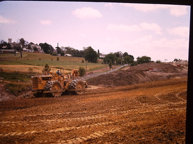
 Kew Historical Society Inc
Photograph - Construction of the F19 [Eastern Freeway], Ron Setford, November 1971
... the development of the F19 (later renamed Eastern) Freeway through ...Ron Setford and his wife Grace Setford lived in Tanner Avenue, East Kew, from c.1946 to c.1995. A keen photographer, he recorded the changing face of Kew over a 20 year period. Apart from 30 photographs of built structures and places in Kew dating from 1960 and 1961, 145 of his 35mm colour slides chronicle the development of the F19 (later renamed Eastern) Freeway through the Yarra Valley in Kew over a five year period from c.1972 to c.1977. This important collection was donated to the Society by his granddaughter in 2025.This collection of 175 35mm slides is of local and statewide significance, owing to its subject matter, particularly the major development of road transport infrastructure during the 1970s with the construction of the Eastern Freeway. The photographer also took care to annotate and date most of his slides which enable the researcher to pinpoint temporal and spatial locations.View of earth moving equipment during the construction of the freeway, with Kew Mental Hospital in the background. "Eastern Freeway / Nov 71"ron setford, eastern freeway, f19 freeway -
 Kew Historical Society Inc
Photograph - Construction of the Eastern Freeway (F19), Ron Setford, 1971
Ron Setford and his wife Grace Setford lived in Tanner Avenue, East Kew, from c.1946 to c.1995. A keen photographer, he recorded the changing face of Kew over a 20 year period. Apart from 30 photographs of built structures and places in Kew dating from 1960 and 1961, 145 of his 35mm colour slides chronicle the development of the F19 (later renamed Eastern) Freeway through the Yarra Valley in Kew over a five year period from c.1972 to c.1977. This important collection was donated to the Society by his granddaughter in 2025.This collection of 175 35mm slides is of local and statewide significance, owing to its subject matter, particularly the major development of road transport infrastructure during the 1970s with the construction of the Eastern Freeway. The photographer also took care to annotate and date most of his slides which enable the researcher to pinpoint temporal and spatial locations.View of earth moving vehicle at the beginning of the construction of the Eastern (F19) Freeway in 1971. Kew Mental Hospital in the background.Nilron setford, eastern freeway, f19 freeway -
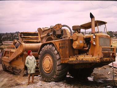 Kew Historical Society Inc
Photograph - Construction of the Eastern Freeway (F19), Ron Setford, November 1971
Ron Setford and his wife Grace Setford lived in Tanner Avenue, East Kew, from c.1946 to c.1995. A keen photographer, he recorded the changing face of Kew over a 20 year period. Apart from 30 photographs of built structures and places in Kew dating from 1960 and 1961, 145 of his 35mm colour slides chronicle the development of the F19 (later renamed Eastern) Freeway through the Yarra Valley in Kew over a five year period from c.1972 to c.1977. This important collection was donated to the Society by his granddaughter in 2025.This collection of 175 35mm slides is of local and statewide significance, owing to its subject matter, particularly the major development of road transport infrastructure during the 1970s with the construction of the Eastern Freeway. The photographer also took care to annotate and date most of his slides which enable the researcher to pinpoint temporal and spatial locations.Closeup view of earth moving vehicle at the beginning of construction of the Eastern (F19) Freeway in 1971 with woman standing beside mover."Eastern Freeway / Nov 71"ron setford, eastern freeway, f19 freeway -
 Canterbury History Group
Photograph - Corner view of shops south east facing shop at Maling Road and Bryson Street, Jan Pigot, 27/03/1993 12:00:00 AM
Coloured photograph of the south eastern facing corner of Maling Road and Bryson Street shops entitled The Blockcanterbury, maling road, shops, telegraph poles, victorian architecture, trees -
Canterbury History Group
Photograph - View of the eastern corner shop No. 8 of Theatre Place, Jan Pigot, 27/03/1993 12:00:00 AM
... View of the eastern corner shop No. 8 of Theatre Place... Place called Home Sweet Home Photograph View of the eastern ...Coloured photograph of the door of the shop at the eastern corner of Theatre Place called Home Sweet Homecanterbury, maling road, shops, theatre place -
 Kew Historical Society Inc
Photograph - Construction of the Eastern Freeway (F19), Ron Setford, November 1971
Ron Setford and his wife Grace Setford lived in Tanner Avenue, East Kew, from c.1946 to c.1995. A keen photographer, he recorded the changing face of Kew over a 20 year period. Apart from 30 photographs of built structures and places in Kew dating from 1960 and 1961, 145 of his 35mm colour slides chronicle the development of the F19 (later renamed Eastern) Freeway through the Yarra Valley in Kew over a five year period from c.1972 to c.1977. This important collection was donated to the Society by his granddaughter in 2025.This collection of 175 35mm slides is of local and statewide significance, owing to its subject matter, particularly the major development of road transport infrastructure during the 1970s with the construction of the Eastern Freeway. The photographer also took care to annotate and date most of his slides which enable the researcher to pinpoint temporal and spatial locations.Closeup view of earth moving vehicle at the beginning of construction of the Eastern (F19) Freeway in 1971"Eastern Freeway / Nov 71"ron setford, eastern freeway, f19 freeway -
 Kew Historical Society Inc
Photograph - Construction of the Eastern Freeway (F19), Ron Setford, November 1971
... the development of the F19 (later renamed Eastern) Freeway through ...Ron Setford and his wife Grace Setford lived in Tanner Avenue, East Kew, from c.1946 to c.1995. A keen photographer, he recorded the changing face of Kew over a 20 year period. Apart from 30 photographs of built structures and places in Kew dating from 1960 and 1961, 145 of his 35mm colour slides chronicle the development of the F19 (later renamed Eastern) Freeway through the Yarra Valley in Kew over a five year period from c.1972 to c.1977. This important collection was donated to the Society by his granddaughter in 2025.This collection of 175 35mm slides is of local and statewide significance, owing to its subject matter, particularly the major development of road transport infrastructure during the 1970s with the construction of the Eastern Freeway. The photographer also took care to annotate and date most of his slides which enable the researcher to pinpoint temporal and spatial locations.View of earth moving vehicle at the beginning of the construction of the Eastern (F19) Freeway in 1971"Eastern Freeway / Nov 71"ron setford, eastern freeway, f19 freeway -
 Kew Historical Society Inc
Photograph - Construction of the Eastern Freeway (F19), Ron Setford, March 1972
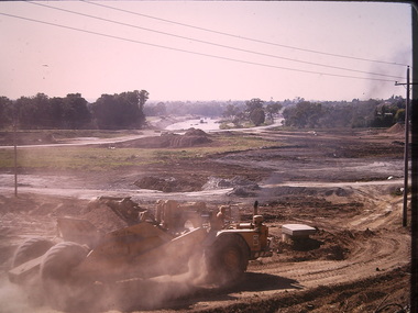
Ron Setford and his wife Grace Setford lived in Tanner Avenue, East Kew, from c.1946 to c.1995. A keen photographer, he recorded the changing face of Kew over a 20 year period. Apart from 30 photographs of built structures and places in Kew dating from 1960 and 1961, 145 of his 35mm colour slides chronicle the development of the F19 (later renamed Eastern) Freeway through the Yarra Valley in Kew over a five year period from c.1972 to c.1977. This important collection was donated to the Society by his granddaughter in 2025.This collection of 175 35mm slides is of local and statewide significance, owing to its subject matter, particularly the major development of road transport infrastructure during the 1970s with the construction of the Eastern Freeway. The photographer also took care to annotate and date most of his slides which enable the researcher to pinpoint temporal and spatial locations.Panoramic view of the Yarra Valley in March 1972 showing the early stages of the construction of the F19 (Eastern) Freeway. The photo shows the construction of an embankment to contain the new river course of the Yarra."Eastern Freeway / New river course preparing for embankment / Mar 72"ron setford, eastern freeway, f19 freeway -
![Photograph - F19 [Eastern Freeway] signage, Ron Setford](/media/collectors/550653872162f11fb04854aa/items/67cbd645494c4da380443cdc/item-media/67cbd667494c4da380443e24/item-fit-380x285.jpg) Kew Historical Society Inc
Kew Historical Society IncPhotograph - F19 [Eastern Freeway] signage, Ron Setford
... / Eastern Freeway" View of a sign stating the start date ...Ron Setford and his wife Grace Setford lived in Tanner Avenue, East Kew, from c.1946 to c.1995. A keen photographer, he recorded the changing face of Kew over a 20 year period. Apart from 30 photographs of built structures and places in Kew dating from 1960 and 1961, 145 of his 35mm colour slides chronicle the development of the F19 (later renamed Eastern) Freeway through the Yarra Valley in Kew over a five year period from c.1972 to c.1977. This important collection was donated to the Society by his granddaughter in 2025.This collection of 175 35mm slides is of local and statewide significance, owing to its subject matter, particularly the major development of road transport infrastructure during the 1970s with the construction of the Eastern Freeway. The photographer also took care to annotate and date most of his slides which enable the researcher to pinpoint temporal and spatial locations.View of a sign stating the start date of construction on the Eastern (F19) Freeway"Title slide / Eastern Freeway"ron setford, eastern freeway, f19 freeway -
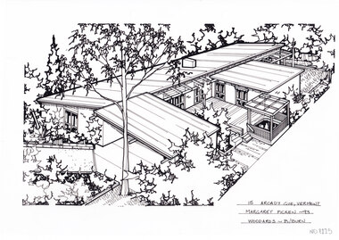 Whitehorse Historical Society Inc.
Artwork, other - Ink Line Drawing, Margaret Picken, 15 Arcady Gve., Vermont, 1993
A property illustration by Margaret Picken Commissioned by a real estate agency for the purpose of advertising 15 Arcady Gve., Vermont This property is listed as having sold for $178,000 in 1995 Made by using Rotring ‘Rapidigraph’ drafting pens with Rotring ink on Rapidigraph polyester drafting film, double matte. Trained as a cartographic draftsman within the mining industry, Margaret Picken is an artist who worked producing property illustrations for real estate agencies in eastern suburbs of Victoria from 1983-2005. Retiring from the industry as technological changes favored coloured photography over illustrations, and commissioning companies over sole contractors.This artwork is of Historical Significance as a record of local domestic architecture.A black ink line drawing on drafters film by Margaret Picken, of a black and white line drawing of a single story brick house from a angled birdseye view, on a left to right diagonal. On the left, a horizontal driveway leads to a connected carport, with the main of the house of the left. Wrapping around a central decked courtyard. There is a backyard in the background in the upper right corner. There are two hole punch holes just below centre of the upper edge15 Arcady Gve., Vermont Margaret Picken -93 Woodards - B/Burnwhitehorse historical society, schwerkolt cottage, housing, architecture, margaret picken, house, garden, real estate, vermont -
 Lakes Entrance Historical Society
Album - Oil Drilling Lakes Entrance, Charlie Carpenter, 1936 c
Photograph album containing views of oil drilling operations in Lakes Entrance area particularly Eastern Bore Lakes Entrance Victoriaoil drilling, local history, oil and gas industry -
 Lakes Entrance Historical Society
Postcard - Lakes Entrance viewed from Jemmys Point, Rose Series, 1925 c
Post and rail fence beside highway and no vegetation on sand dunes eastern part of Cunninghame ArmBlack and white postcard showing view of Cunninghame Arm from Jemmys Point, gravel Princes Highway, North Arm bridge and end of town Lakes Entrance VictoriaNearing Lakes Entrance on the Princes Highwaytownship, waterways -
 Lakes Entrance Historical Society
Postcard - New Works Lakes Entrance, 1920 c
Also a second black and white postcard with view of entrance taken from Kalimna hill 05365.1 showing the western side housesColoured postcard of the entrance and New Works buildings showing end of Bullock Island with huts and other buildings on the Eastern/ New Works side of the Entrance Lakes Entrance Victoriawaterways, houses -
 Clunes Museum
Photograph, KODAK, 1999
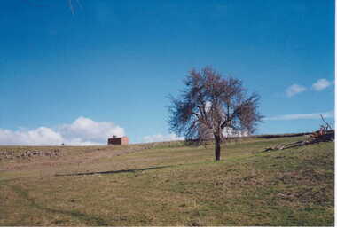
VIEW OF POWDER MAGAZINE USED IN MINING DAYS TO STORE EXPLOSIVES. BUILDING MATERIALS SOLID BRICKCOLOURED PRINT PHOTOGRAPH OF POWDER MAGAZINE EXTERIOR. SITUATED IN A PADDOCK ON SMEATON ROAD APPROX. 2 KM. FROM TOWNSHIP ON LEFT HAND SIDE. LEAFLESS TREE IN FOREGROUND - FALLEN TREE BESIDE IT EASTERN ASPECT.local history, photography, photographs, mining -
 Lakes Entrance Historical Society
Photograph - The Entrance Lakes Entrance, 1920 c
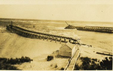
Also two other black and white photographs taken at same time , one of the ocean end of western pier and one of eastern pier taken looking towards Kalimna and Jemmys Point 05294.1 and 05294.2Black and white photograph of view of the entrance to Gippsland Lakes showing east and west piers and kiosk building next to boardwalk to eastern pier Lakes Entrance Victoriawaterways, piers -
 Whitehorse Historical Society Inc.
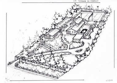
Artwork, other - Ink Line Drawing, Margaret Picken, 103 Terrara Rd. Vermont, circa 1985-2005
A property illustration by Margaret Picken Commissioned by a real estate agency for the purpose of advertising 103 Terrara Rd. Vermont. This property is listed as having sold in for $400,000 in 1986, and having been sold twice in the interim, sold again in 2004 for $1,080,000. Made by using Rotring ‘Rapidigraph’ drafting pens with Rotring ink on Rapidigraph polyester drafting film, double matte. Trained as a cartographic draftsman within the mining industry, Margaret Picken is an artist who worked producing property illustrations for real estate agencies in eastern suburbs of Victoria from 1983-2005. Retiring from the industry as technological changes favored coloured photography over illustrations, and commissioning companies over sole contractors.This artwork is of Historical Significance as a record of local domestic architecture.A black ink line drawing on drafters film by Margaret Picken, of a birds eye view of a property shown on the diagonal. In the bottom left corner a gated driveway winds toward the upper right, through landscaped gardens. Leading up to a separate multi car garage. There is a sperate annex left of the garage, and the main two story house further back. At the every end of the property is a tennis court.103 Terrara Rd. Vermontwhitehorse historical society, schwerkolt cottage, housing, architecture, margaret picken, house, garden, real estate, vermont, vermont south -
 Whitehorse Historical Society Inc.
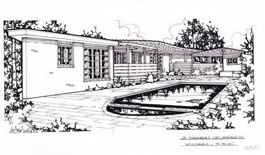
Artwork, other - Ink Line Drawing, Margaret Picken, 14 Shearers Crt., Vermont Sth, 1996
A property illustration by Margaret Picken Commissioned by a real estate agency for the purpose of advertising 14 Shearers Crt., Vermont Sth. This property is listed as having sold for $240,000 in 1996 Made by using Rotring ‘Rapidigraph’ drafting pens with Rotring ink on Rapidigraph polyester drafting film, double matte. Trained as a cartographic draftsman within the mining industry, Margaret Picken is an artist who worked producing property illustrations for real estate agencies in eastern suburbs of Victoria from 1983-2005. Retiring from the industry as technological changes favored coloured photography over illustrations, and commissioning companies over sole contractors.This artwork is of Historical Significance as a record of local domestic architecture.A black ink line drawing on drafters film by Margaret Picken, of a single story, L shape, brick house viewed from the tiled backyard with sunken pool. There is a hole punched semi circle cut out on the upper edge of the artwork.14 Shearers Crt., Vermont Sth Woodards - B/Burnwhitehorse historical society, schwerkolt cottage, housing, architecture, margaret picken, house, garden, real estate, vermont, vermont south -
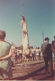 Lakes Entrance Historical Society
Photograph - Australian Anglers Association Carnival and Convention Lakes Entrance c1955
04308.1, 12 x 13 cmColour photograph of campers from Carpenters Camp Park viewing a large shark caught at sea and hanging on the Eastern Wharf Lakes Entrance Victoria c1965. Also a black and white photograph of the Australian Anglers Association Carnival and Convention marquee set up on Esplanade shows two memorial cypresses a number of cars parked and onlookers near marquee taken 1955 cevents, fishing, caravan parks, gippsland lakes