Showing 316 items
matching ethel street
-
 Port Melbourne Historical & Preservation Society
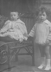
Photograph - David and Ronald Hume, 1919
Photo of David Hume - (on right) and brother Ronald Hume. Local residents of South Melbourne . Mother was Ethel, father David, and two more brothers Norm and George. Photo taken early 1900sfamilies, david hume, ronald hume, vera hume, ethel hume, norm hume, george hume -
 Port Melbourne Historical & Preservation Society
Photograph - Women workers, Swallow & Ariell, 1920s
Photograph of women workers at Swallow & Ariell in the 1920s. One of the workers - not identified - is Ethel SHARMAN who later became the mother of the Hume boys noted in cat no.3793families, industry - food, business and traders - bakers, ethel sharman, vera hume -
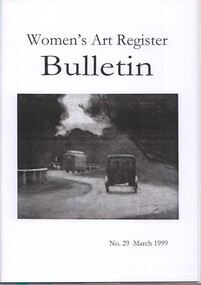 Women's Art Register
Women's Art Register Bulletin
Magazineclarice beckett, gail stiffe, liza mccosh, judy horacek, rosemary mangiamele, ethel burrows 1882-1976, amelia burrows 1860-1927, amy lakides 1918-1927, beatrice tait 1922-1993 -
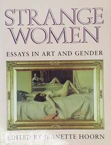 Women's Art Register
Book - Anthology, Jeanette Hoorn, Strange Women. Essays in Art and Gender, 1994
The masculine landscape tradition was seen as the 'true' national identity in the early 20th century while the new Modernist painting of women was seen as marginal and incidental. This text looks behind the commonly held narratives of art criticism to present a new reading of gender in Australian painting.Booknon-fictionThe masculine landscape tradition was seen as the 'true' national identity in the early 20th century while the new Modernist painting of women was seen as marginal and incidental. This text looks behind the commonly held narratives of art criticism to present a new reading of gender in Australian painting.grace cossington smith, thea proctor, margaret preston, grace crowley, hilda fix nicholas, sybil craig, ethel carrick -
Port Melbourne Historical & Preservation Society
Document - Research report, Robyn Clinch, History of some Women of Port Melbourne, Nov 2002
A project funded by City of Port Phillip Cultural DevelopmentHistory of some Women of Port Melbourne, book reporting on research conducted for the Port Melbourne Historical and Preservation Society by Robyn Clinch November 2002, 61pp. Bound with black plastic comb. Colour photographs. Two black and white copies in C.22.01families, women, domestic life, robyn clinch, gabriel maree alaston dawson, mary ann 'ma' bennett mccormack, sarah jean bunsell, ethel mary howe, jane mckenna slaven, winifred mary prest woodruff, caroline jean 'minnie' coleman (kornman) beazley, jane rendall nee harrison -
 Port Melbourne Historical & Preservation Society
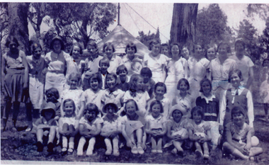
Photograph, Douglas Smallpage?, Ross St Baptist Sunday School, 1930s - 1940s
Digital image of Ross St Baptist Sunday School picnic in early 1930s. Hard copies of photos of similar period at 1876 .01-.24education - primary schools, religion - baptist church, doug smallpage, keith jenkins, roland harris, valerie young, ethel croxon, joy duncan, iris caton, myrna jackson, william lowson, ross street -
 Coal Creek Community Park & Museum
Bottle, glass, c. 1862 - c.1934
TROVE : Age (Melbourne, Vic. : 1854 - 1954), Saturday 11 October 1862, page 8 ‘…..AYER'S SARSAPARILLA FOR PURIFYING THE BLOOD; A compound remedy, designed to be the most effectual Alterative that can be made. It is a concentrated extract of Para Sarsaparilla, so combined with other substances of still greater alternative power as to afford an effective antidote for the diseases Sarsaparilla is reputed to cure. It is believed that such a remedy is wanted by those who suffer from Strumous complaints, and that one which will accomplish their cure must prove of immense service to this large class of our afflicted fellow-citizens. How completely this compound will do it has been proven by experiment on many of the worst cases to be found of the following complaints : — Scrofula and Scrofulous complaints, Eruptions and Eruptive Diseases, Ulcers, Pimples, Blotches, Tumora, Salt Rheum, Scald Head, Syphillis and Syphillitic Affections, Mercurial Disease, Dropsy, Neuralgia or Tic Doloreux, Debility, Dyspepsia and Indigestion, Erysipelas, Rose, or St. Anthony's Fire, and, indeed, the whole class of complaints arising from impurity of the blood. This compound will be found a great promoter of health, when taken in the Spring, to expel the foul humors which fester in the blood at that season of the year. By the timely expulsion of them many rankling disorders are nipped in the bud. Multitudes can, by the aid of this remedy, spare themselves from the endurance of foul eruptions and ulcerous sores, through which the system will strive to rid itself of corruptions, if not assisted to do this through the natural channels of the body by an alternative medicine. Cleanse out the vitiated blood whenever you find its impurities bursting through the skin in pimples, eruptions, or sores ; cleanse it when you find it is obstructed and sluggish in the veins ; cleanse it whenever it is foul, and your feelings will tell you when. Even where no particular disorder is felt, people enjoy batter health, and live longer, for cleansing the blood. Keep the blood healthy, and all is well; but with this pabulum of life disordered, there can be no lasting health. Sooner or later something must go wrong, and the great machinery of life is dis ordered or overthrown. Sarsaparilla has, and deserves much, the reputation of accomplishing these ends. But the world has been egregiously deceived by preparations of it, partly because the drug alone has not all the virtue that is claimed for it, but more because many preparations, pretending to be concentrated extracts of it, contain but little of the virtue of Sarsaparilla, or anything else. _ During late years, the public have been misled by large bottles, pretending to give a quart of Extract of Sarsaparilla for one dollar. Most of these have been frauds upon the sick, for they not only contain little, if any, Sarsaparilla, but often no curative properties whatever. bitter and painful disappointment has followed the use of the various extracts of Sarsaparilla which flood the market, until the name itself is justly despised, and has become synonymous with imposition and cheat. Still, we call this compound Sarsaparilla, and intend to supply such a remedy as shall rescue the name from the load of obloquy which rests upon it. And we think we have ground for believing it has virtues which are irresistible by the ordinary run of the diseases it is intended to cure. In order to secure their complete eradication from the system, the remedy should be judiciously taken according to directions on the bottle. Prepared by DR. J. C; AYER and CO., Lowell, Mass. HENRI J. HART, Sole Wholesale Agent, 21 Queen street south. Sub-agents required for all the interior towns.’ TROVE : Herald (Melbourne, Vic. : 1861 - 1954), Monday 12 November 1934, page 4 DOCTORS SHOW QUICK WAY TO END STOMACH TROUBLE Miss Ethel Phillips, Like Numbers of Victorian People, Surprised to Find How Quickly Freedom from Indigestion Improves Health, Increases Vigor and Makes One's Complexion Healthier and More Radiant. More and more Victorian people are finding that the way one looks and feels depends largely on one's digestion. And .they have learned that Ayer's Sarsaparilla — by ending indigestion — gives one increased strength, steadier nerves, clearer skin, and the improved appearance that can come only from improved health. (Photo) : HOSPITAL NURSE ENDS GASTRIC INDIGESTION BY TEMPTING TASTE OF SARSPARILLA AT MEALTIME Tall clear aqua tinted glass bottle, rectangular in section, with rectangular panels impressed on four sides with embossed text in the four panels. A shallow dome impression on the base containing embossed text.Side 1 : 'AYER'S'. Side 2 : 'COMPOUND EXT.' Side 3 : 'LOWELL MASS. U.S.A.'. Side 4 : 'SARSAPARILLA'. Base 'C57'.ayer's, sarsaparilla, compound extraction -
Port Melbourne Historical & Preservation Society
Document - Calendar 2021, Pat Grainger and PMHPS members, Historic Port Melbourne - Women of Port, September 2020
Researched, written and designed by Pat GRAINGER and PMHPS members"Historic Port Melbourne - Women of Port 2021" Produced by PMHPS. Black and white cover with portrait of Caroline LIARDET and dog. PMHPS logo at top right.ladies harbour lights guild, religion - anglican (holy trinity), norah howard nee mallet, janne ray, caroline liardet, sarah stella edwards, sarah whiteman, eli (dick) edwards, women's welcoming committee, george samson, albert 'joe' budd, mary elizabeth freame, mary ada a'beckett, lady foster, ethel godfrey, alice tracey, stan howard, joan round, jean schinck, jenny tserkezidis, joyce dermott, diane perazzo, heather wale, mother anthony, lilian 'lil' goss nee johnson, peggy howard nee antonio, george baines, mary mcleavy, lyn mcleavy, jan soldatos nee harris, anna robieson, liana thompson, destiny deacon, jude munro, wendy morris, janet bolitho, lyn allison, bernadene voss, moira findlay, fiona mcconnell, beris campbell, rosie bray, pat grainger, janet phillicia batty, margaret addicoat, thomas edwards, norm goss snr, mary anthony byrne, sarah jane 'jennie' baines nee hunt, annie samson nee anderson, sister norma jean barnett, jane rendall nee harrison -
 Port Melbourne Historical & Preservation Society
Photograph - Group containing Ethel Mavis Nyman, c.1945
Photograph of eight women. Back Row L - R - D. MONTAGUE; A LEADEN; M WALTON. Middle Row L - R - P. NICOL; J. FRY; E. NYMAN (Ethel Mavis NYMAN). Front Row L - R - D. POTTER; C. JONES Ethel NYMAN (17), who lived in Coburg ,was murdered on Port Melbourne Beach on the evening of 2 Feb 1946. Her killer was apprehended the next day.Small sepia photograph of 8 women against a bush background On reverse names of the women plus * Found murdered under Station Pierport melbourne beach, p. nicol, j fry, ethel mavis nyman, d potter, c jones, a leaden, m walton, d montague -
 Port Melbourne Historical & Preservation Society
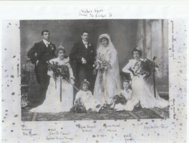
Photograph - Wedding of Walter ELDEN & Agnes MENNIE, 1901
Wedding couple Walter Ricard ELDEN & Agnes Mabel MENNIE, stand in the centre with best man , George BLENKOON. Seated on left is a cousin Ethel CATLIN and on the right Isabella DOW. Two young girls sit in front of the bride & groom. Edith CATLIN is on the right but the other girl is unknown.Photocopy of 1901 wedding goup -Walter Richard ELDEN and Agnes Mabel MENNIE & attendants.Walter & Agnes lived at 54 Evans Street, Port Melbourne. celebrations- weddings, walter richard elden, agnes mabel mennie, isabella dow, edith catlin, ethel catlin, george blenkoon -
 Bendigo Historical Society Inc.
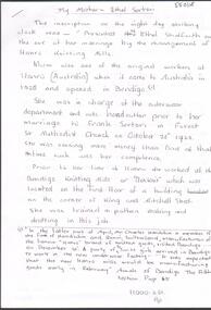
Document - HANRO COLLECTION: ETHEL SERTORI MEMOIRS, 2018
Handwritten Memoir of Ethel Sertori, one of the original workers at Hanro when the factory opened in 1926. Three pages.Ethel Sertoriperson, individual, ethel sartori -
 Bendigo Historical Society Inc.
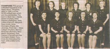
Newspaper - JENNY FOLEY COLLECTION: CHAMPIONS
Bendigo Advertiser "The way we were" from Wednesday, July 7, 2004. Champions: this group of softballers had plenty to be happy about. This photo, taken in 1946, is of the NCSN softball team which won the premiership. The team is back row: Gertie Sexton ( forbes), Ethel Pearson (Gallagher), Betty Collins (Cannon), Margaret Ryan (Lock), Anne Donnington (Flack), Win Jennings. Front row: Mase Calligan (Purdon), Bernice Mulqueen (Bormeo), Mary Mason (Brosman), Kath Pearson (Pannell) and Rae Domington (Dalty).newspaper, bendigo advertiser, the way we were -
 Bendigo Historical Society Inc.
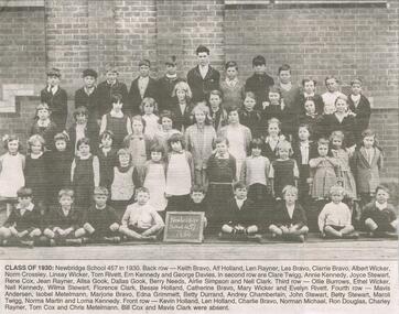
Newspaper - JENNY FOLEY COLLECTION: CLASS OF 1930
Bendigo Advertiser "The way we were" from Friday, April 22, 2005. Class of 1930: Back row: Keith Bravo, Alf Holland, Len Rayner,Les Bravo, Clarrie Bravo, Albert Wicker, Norm Crossley, Linsay Wicker, Tom Rivett, Ern Kennedy ang George Davies. Second row: Clare Twigg, Annie Kennedy, Joyce Stewart, Rene Cox, Jean Rayner, Allsa Gook, Dallas Gook, Berrie Needs,, Airlie Simpson and Nell Clark. Third row: Ollie Burrows, Ethel Wicker, Nell Kennedy, Wilma Stewart, Florence Clark, Bessie Holland, Catherine Bravo, Mary Wicker and Evelyn Rivett. Fourth row: Mavis Andersen, Isobel Metelmann, Marjorie Bravo, Edna Grimmett, Betty Durrand, Audrey Chamberlain, Jon Stewart, Betty Stewart, Maroli Twigg, Norma Martin and Lorna Kennedy. Front row: Kevin Holland, Len Holland, Charlie Bravo,Norman Michael, Ron Douglas, Charley Rayner, Tom Cox and Chris Metelmann. Bill Cox and Mavis Clark were absent.newspaper, bendigo advertiser, the way we were -
 Bendigo Historical Society Inc.
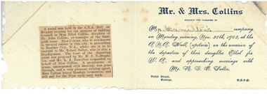
Document - HAMILTON COLLECTION: INVITATION, 30/11/1903
Document. Invitation to a Social Evening at the ANA Hall 30/11/03 to Mr Hamilton to attend to farewell Miss Ethel Collins, who was departing for W.A. to marry Mr Robert Salter. Newspaper report of the evening posted inside the invitation.performing arts, elocution, invitation -
 Bendigo Historical Society Inc.
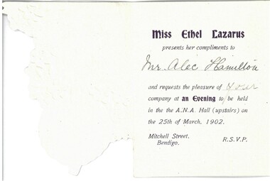
Document - HAMILTON COLLECTION: INVITATION, 25 March 1902
Document. Tri-fold invitation to Mr Alec Hamilton to attend ''An Evening'' at the ANA Hall on 25th March 1902, from Miss Ethel Lazarus.performing arts, elocution, invitation -
 Bendigo Historical Society Inc.
Newspaper - JENNY FOLEY COLLECTION: GROUP SHOT
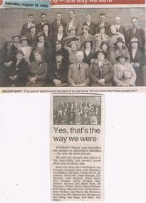
Bendigo Advertiser "The way we were" from Saturday, August 16, 2003. Group shot: Warren Winzar has identified the people in this picture. The picture was taken in the mid 1930s. Back row from left: Les Holland, Les Stewart, Norman Hart, Jack Simpson, Syd Wicker, Bill Hart, Frank Bruce, Mr. Dobbin. Third row: Jessie Ramsay, Lily Michael, Leila Ramsay, Edna Apoo, Kay Grogan, Molly Grogan, May Malone. Second row: ethel Hart, Ms. Simpson, Flossie Bruce, Mary Holland, Edie King, Alice Burrows, Stella Bravo, Gert Wicker, Lily Finch, Ms. Peterson. Front row: Mrs. Mackenzie, Ms. Rayner, Mrs. King, Jim King,Mrs. Hart, Mrs. Bravo.newspaper, bendigo advertiser, the way we were -
 Bendigo Historical Society Inc.
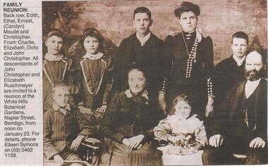
Newspaper - JENNY FOLEY COLLECTION: REUNION
Bendigo Advertiser "The way we were" from Thursday, January 6, 2005. Reunion: Back row: Edith, Ethel, Ernest, Carolyn Maude and Christopher. Front: Charlie, Elizabeth, Dolly and John Christopher. All descendants of John Christopher and Elizabeth Ruschmeyer are invited to a reunion.newspaper, bendigo advertiser, the way we were -
 Bendigo Historical Society Inc.
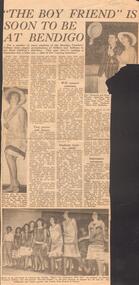
Document - LA TROBE UNIVERSITY BENDIGO COLLECTION: 'THE BOY FRIEND'
A Bendigo advertiser article titled 'The Boy Friend is Soon To Be At Bendigo'. This article includes photos of the Bendigo Teachers' College cast rehearsing for 'The Boy Friend'. (a) A photo of Noel Thompson and Eileen Florence rehearsing their song 'I could be happy with you'. (b) A photo of Ethel Prichard who plays the role of the French maid Hortense. (c) The third photo is of the cast singing 'Wont you charlston with me?' Dated C 1960.bendigo, education, performing arts, la trobe university bendigo collection, collection, bendigo teachers' college, bendigo teachers' college students, bendigo, education, tertiary education, drama, musical, entertainment, music, dancing, costume, theatre, performing arts, photo, photograph -
Bendigo Historical Society Inc.
Document - GOLDEN SQUARE METHODIST CHURCH TENNIS CLUB GRAND CONCERT & SOCIAL, c1930
Golden Square Methodist Church Tennis Club Grand Concert & Social held in the school Hall. Tuesday June 2nd, at 7.45 c1930. Participants Misses A and L Saunders, Mr Will Brown, Miss Ethel Cravino, Miss Lila Peatling, Master Duncan McDonald. Miss Irene Dorrity, Mr A Kirby, Miss Lily Walker, Mr Hector Taylor, Miss Audrey Courtis, Mr Irvine Brimacombe and Nellie Roach. Accompaniste Miss A Saunders, Chairman Mr R Saunders. Admission 6d. Lydia Pethard Hon. Sec. Printed by Cambrige Press, The Printers, Bendigo. Copy a is in excellent condition and unmarked. Copy b is in excellent condition but has be written on across top May 12th 1929 Welcome Home along bottom on front Welcome Show March 27 1919 June 26th 1919 Oct 2nd 1919. On back is written: Back to Numurkah 23rd to 29th March 1951 meat with G & H & their grandsons Geo & David Back to Huntly 1939 took mother 8 & 9th April.Cambridge Press, The printers, Bendigoprogram, music, golden quare methodist tennis club, golden square methodist church tennis club grand concert & social held in the school hall. c1930. participants a and l saunders, will brown, ethel cravino, lila peatling, duncan mcdonald. irene dorrity, r a kirby, lily walker, hector taylor, audrey courtis, irvine brimacombe and nellie roach. accompaniste a saunders, chairman r saunders. admission 6d. lydia pethard hon. sec. printed by cambrige press, the printers, bendigo. copy a is in excellent condition and unmarked. copy b is in excellent condition but has be written on across top may 12th 1929 welcome home along bottom on front welcome show march 27 1919 june 26th 1919 oct 2nd 1919. on back is written: back to numurkah 1951 meat with g & h & their grandsons geo & david back to huntly 1939 took mother 8 & 9th april. -
 Bendigo Historical Society Inc.
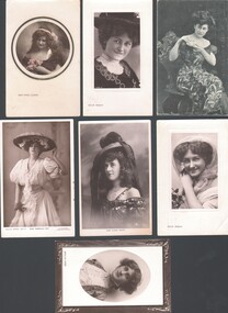
Postcard - WES HARRY COLLECTION: 7 POSTCARDS, 1907 - 09
Group of seven postcards depicting actresses, addressed to Mrs. A. Stephens : (a) Miss Tittell Brune, (b) Phyllis Dare, (c) Miss Gabrielle Ray, (d) Miss Carrie Moore, (e) Delia Mason, (f) Miss Ethel Oliver, (g) Delia Mason.postcard, photograph, actresses, delia mason, ethel oliver, carrie moore, gabrielle ray, phyllis dare, tittell brune, actresses, theatre -
 Bendigo Historical Society Inc.
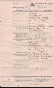
Document - DEATH CERTIFICATE: ETHEL DAISY FIELD, 1946
Document: Death certificate of Ethel Daisy Field, descendant of George Lansell. Died 11th. October, 1946, 24 Booth Street, Arncliffe, Rockdale.NSW Govt.place, fortuna, family history, fortuna, lansell, bendigo. ethel daisy field -
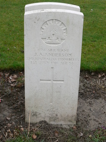 Victorian Interpretive Projects Inc.
Photograph - Colour, Mark Banning, Photograph of the gravestone of John A. Alexander, 2014, 18/02/2014
John Austin Anderson was the son of Daniel William and Elizabeth Jane Anderson, and husband of Ethel M. Anderson of 312 Ripon Street South, Ballarat. John Anderson was a sergeant with the 2nd Australian Tunnelling Company. He was 34 years of age when he was killed in action in France on 01 July 1916. Anderson is buried at Cite Bonjean Military Cemetery, Armentieres.Four digital images images of the headstones for J.A. Anderson in the Cite Bonjean Military Cemetery, Armentieres, taken by Mark Banning on 18 February 2014. world war one, wwi, war, cemetery, headstone, alexander, j.a. alexander., mmm -
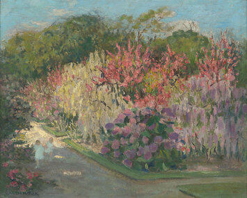
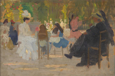 Benalla Art Gallery
Painting, Ethel CARRICK, In the Luxembourg Gardens (Champs Elysee), c. 1910
Born: Uxbridge, Middlesex, England 1872; Active Australia from 1908; Died: Melbourne, Victoria, Australia 1952ImpressionismGift of Mrs Erma Ledger, 1981Garden setting with figures and chairs. Carved gold painted timber frame.Recto: Not signed; Not dated; Not titledgarden, figures, chairs, australian art -
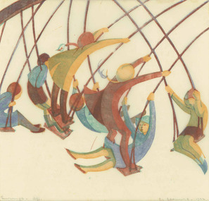 Benalla Art Gallery
Print, Ethel SPOWERS, Swings, 1932
Born: Melbourne, Victoria, Australia 1890; Died: 1947ModernismBennett Bequest, 2000 Figures depicting children on swings. Gold painted wooden frame.Recto: Signed and dated "E.L.Spowers - 1932" in grey ink l.r.c of composition; Titled "Swings - 21/50" in grey ink l.l.c.print, japanese tissue paper, children, playing, swings, linocut, australian art -
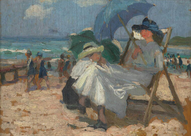 Benalla Art Gallery
Painting, Ethel CARRICK, Beach scene, Sydney (Manly Beach), c. 1910
Born: Uxbridge, Middlesex, England 1872; Active Australia from 1908; Died: Melbourne, Victoria, Australia 1952ImpressionismGift of Pamela Davies, 2005Seaside landscape with seated figure and figures on sand and in the water.Recto: Not signed; Not dated; Not titledbeachscape, figures, summer, sand, waves, umbrella, australian art -
 Benalla Art Gallery
Painting, Ethel CARRICK (FOX), In the Botanic Gardens, 1913, 1913
Born: Uxbridge, Middlesex, England 1872; Arrived: Melbourne, Victoria, Australia c.1914; Lived and worked: France 1905-1913, Australia: 1908 and 1913, Europe, Middle East and Asia 1916- c.1936; Died: Melbourne, Victoria, Australia 1952ImpressionismLedger Gift, 1980Garden setting with flowers, trees and small figures running down a path. Bronze brushed carved timber frame.Recto: Signed "CARRICK FOX" in deep navy oil in l.l.c of composition; Not dated; Not titledpainting, garden, figures, flowers, children, trees, path -
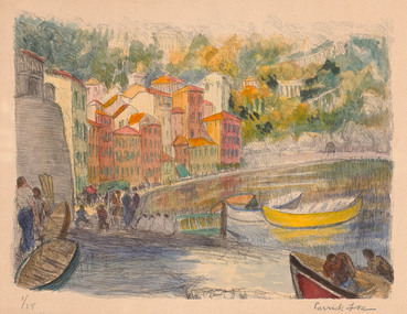 Benalla Art Gallery
Print, Ethel CARRICK, (Houses. Water. Boats), Not dated
Born: Uxbridge, Middlesex, England 1872; Arrived: Melbourne, Victoria, Australia c.1914; Lived and worked: France 1905-1913, Australia: 1908 and 1913, Europe, Middle East and Asia 1916- c.1936; Died: Melbourne, Victoria, Australia 1952ImpressionismMajor Basil MacNay Bequest, Gift of Arts Victoria, 1998Hand-coloured lithograph depicting colourful buildings, boats and figures along shoreline. UnframedRecto: Signed "Carrick Fox" in black pencil in l.l.c of composition; "1/25" in black pencil in l.r.c of compositon; Not dated; Not titledprint, waterscape, boats, houses, bridge, figures, europe, trees, hill, water -
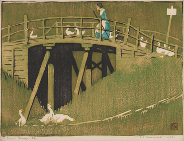 Bendigo Art Gallery
Print - Work on paper, Ethel SPOWERS, The Green Bridge, 1926-1927
l.r; ELS seal, l.r; The Green Bridge 27, l.r; E.L Spowers 1926print, printmaker, printmaking, woodblock, female artist, linocut, bridge, ducks, farming, farm, countryside -
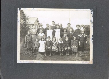 Clunes Museum
Photograph, c1908
Sepia photograph mounted on cardboard of pupils at the Tourello schoolOn Reverse; (written in blue biro) Tourello School Back Row: Chrissie Turnbull, Chris McRae, Colin Robertson, Arthur Roberts, Les Martin, Nicholas Grenfell, Miss Christie, unknown Middle Row: Bill Boyd, Bessie Scarffe, Ethel Turnbull, Lillian Roberts, Alec McRae, Bert Turnbull, Evelyn Grenfell Sitting: Cyril Boyd, Rene Trewin, Alex Trewin, Lyn Turnbull, Bill Grenfell, Norman Martin, unknown Stamped: W.H. Poiner Albert Street Clunes poiner, tourello, school -
Clunes Museum
Document - NOTEBOOK
.1 Grey hardcover notebook containing handwritten personal notes taken by Enid Steart during the years 1995-1996 as a member of the Clunes C.W.A. (Country Women's Association) .2 Typed copy of the Clunes Branch Annual Report 1994-1995 signed by Enid Steart, Hon. Secretary. .3 Programme of the C.W.A. Australia Day Dinner held Thursday 26th January 1984, Phyllis Quick Group President and Olive Ritchie Group Secretary .4 Programme of songs presented with the compliments of Mrs. V. Egan Group President, Ballarat Group (undated) .5.6 Newspaper cuttings with photographs (undated) of the 25th year of celebrating Australia Day, .3 Handwritten names of Clunes C.W.A. members Enid Steart, Amy Vinicombe, Janet Illegible, Lois Ritchie, Judith Ritchie, Lena Wattleworth, Inez Mahar, Ethel Johson, Grace Dore, Win Ross, Margaret Grenfell, Janet Rowe.clunes cwa, 25th australia day celebrations