Showing 205 items matching "eucalyptus tree"
-
 Chiltern Athenaeum Trust
Photograph
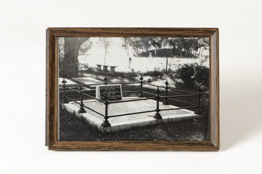
This black and white photograph of the grave of A.W. Eustace is believed to have been taken in September 1987 at the Chiltern New Cemetery. Alfred William Eustace, an Australian artist, was born in the small village of Ashbury, Berkshire, England, the son of John Eustace, Head Game-keeper to the Earl of Craven at the beautiful Ashdown Park. He migrated to Australia with his wife and children in 1851 and camped next to the Ullina and Eldorado Runs on the Black Dog Creek at Chiltern, which was owned by the Withers family and was in excess of 55,000 acres of grazing land. A.W. Eustace was employed as a shepherd by Jason Withers and while tending his flocks in the solitude of the bush, Eustace turned his attention to painting and music to while away the long and weary hours. He endeavoured to capture the spirit of the bush painting on board, canvas or tin plate, but as these materials were not always readily available he then started painting on large round eucalyptus leaves from the White and Red Box trees that grew around about him. About 1856 he painted a small picture of the famous Woolshed goldrush and during the next few years became well known in North-East Victoria. John Sadlier, a police officer stationed at Beechworth said that Eustace painted 'some really exquisite scenes. He was of an easy-going dreamy temperament, a student of nature only, despising the works of men. Unfortunately his drawings were on eucalyptus leaves, the largest and roundest he could find and not on canvas, and no doubt have all perished long ago.' In 1876 the Melbourne Age newspaper reported, 'Eustace’s celebrated paintings on gum leaves are again attracting attention,…Mr Eustace is an elegant artist…he seems without effort to catch the colour and spirit of Australian scenery…' In 1864 A.W. Eustace held an Art Union in Albury, and again in 1884 in Ballarat. He exhibited at the Victorian Academy of Arts in 1877 and also held an exhibition of gum leaf paintings at Stevens Gallery, Melbourne in 1893. By 1896 he was receiving orders from heads of states in Europe, with his works acknowledged by Queen Victoria, Emperor Frederick of Germany and the Czar of Russia, as well as the Governors of New South Wales and Victoria. His paintings reflected his ability to paint the sky in his realistic style which is still noted by art critics of the day. A.W. Eustace was also a skillful taxidermist. The collection of birds and animals that are in the Beechworth Museum collection are examples of his taxidermy skill. When not doing his work, painting or taxidermy, he regularly contributed letters and verse to the Chiltern newspaper, The Federal Standard. A book of verse in his hand writing was presented to The Athenaeum Trust by his relatives from the Boadle family. In the 1870’s he became interested in spiritualism often being involved in lively debate at lectures and séances. Alfred William Eustace died in 1907 and is buried in the Chiltern New Cemetery with his wife Sarah and one of his daughters, Elizabeth.A. W. Eustace, as well as being a well-known Australian artist, was a significant member of the Chiltern community.Black and white photograph of the grave of A.W. Eustace, under glass, in a metal frame.Sticker on back: 184 (original Registration number)a. w. eustace, grave, chiltern new cemetery -
 Chiltern Athenaeum Trust
Photograph
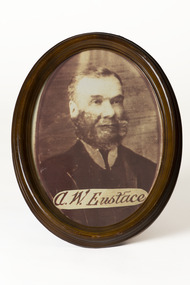
Alfred William Eustace (1820-1907), an Australian artist, was born in Berkshire, England, where he was an assistant gamekeeper to the Earl of Craven at Ashdown Park. He migrated to Australia with his wife and children in 1851 and camped beside the Ullina and Eldorado Runs on the Black Dog Creek at Chiltern, which was in excess of 50,000 acres of grazing land. A.W. Eustace was employed as a shepherd by Jason Withers and while tending his flocks in the solitude of the bush, Eustace turned his attention to painting and music to while away the long and weary hours. He endeavoured to capture the spirit of the bush and painted on board, canvas or tin plate, but as these materials were not always readily available he then started painting on large round eucalyptus leaves from the White and Red Box trees that grew around about him. He became known as the "Bush Artist." About 1856 he painted a small picture of the famous Woolshed goldrush and during the next few years became well known in North-East Victoria. John Sadlier, a police officer stationed at Beechworth said that Eustace painted 'some really exquisite scenes. He was of an easy-going dreamy temperament, a student of nature only, despising the works of men. Unfortunately his drawings were on eucalyptus leaves, the largest and roundest he could find and not on canvas, and no doubt have all perished long ago.' In 1876 the Melbourne Age newspaper reported, 'Eustace’s celebrated paintings on gum leaves are again attracting attention,…Mr Eustace is an elegant artist…he seems without effort to catch the colour and spirit of Australian scenery…' In 1864 A.W. Eustace held an Art Union in Albury, and again in 1884 in Ballarat. He exhibited at the Victorian Academy of Arts in 1877 and also held an exhibition of gum leaf paintings at Stevens Gallery, Melbourne in 1893. By 1896 he was receiving orders from heads of states in Europe, with his works acknowledged by Queen Victoria, Emperor Frederick of Germany and the Czar of Russia, as well as the Governors of New South Wales and Victoria. His paintings reflected his ability to paint the sky in his realistic style which is still noted by art critics of the day. A.W. Eustace was also a skilful taxidermist. The collection of birds and animals that can be seen at the Beechworth Museum are examples of his taxidermy skill. When not doing his work, painting or taxidermy, he regularly contributed letters and verse to the Chiltern newspaper, The Federal Standard. A book of verse in his hand writing was presented to The Athenaeum Trust by the Boadle family. In the 1870’s he became interested in spiritualism often being involved in lively debate at lectures and séances. Alfred William Eustace died in 1907 and is buried in the Chiltern New Cemetery with his wife Sarah and one of his daughters, Elizabeth. A.W. Eustace was a significant member of the Chiltern community during the 19th century and his artwork was displayed widely, even in European royal homes.Copy of sepia photograph of A.W. Eustace in a brown wooden oval frame with a copy of A.W. Eustace's signature across the bottom of the photograph.Sticker on back: 194 Sticker on back: MADE IN/ CHINA/ FABRIQUE 'AU/CHINEa.w.eustace, photograph, chiltern -
 Chiltern Athenaeum Trust
Photograph - Reproduction
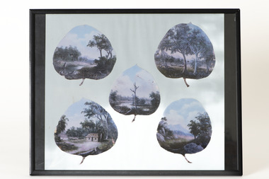
These copies of five oil on gum leaf paintings by Alfred William Eustace (1820-1907) display the subjects and detail of his small gum leaf paintings. A.W. Eustace, a well-known Australian artist, was born in Berkshire, England, where he was an assistant gamekeeper to the Earl of Craven at Ashdown Park. He migrated to Australia with his wife and children in 1851 and worked on the Ullina and Eldorado Runs on the Black Dog Creek at Chiltern, which was in excess of 50,000 acres of grazing land. A.W. Eustace was employed as a shepherd by Jason Withers and while tending his flocks in the solitude of the bush, Eustace turned his attention to painting and music to while away the long and weary hours. He endeavoured to capture the spirit of the bush and painted on board, canvas or tin plate, but as these materials were not always readily available he then started painting on large round eucalyptus leaves from the White and Red Box trees that grew around about him. He became known as the "Bush Artist." About 1856 he painted a small picture of the famous Woolshed goldrush and during the next few years became well known in North-East Victoria. John Sadlier, a police officer stationed at Beechworth said that Eustace painted 'some really exquisite scenes. He was of an easy-going dreamy temperament, a student of nature only, despising the works of men. Unfortunately his drawings were on eucalyptus leaves, the largest and roundest he could find and not on canvas, and no doubt have all perished long ago.' In 1876 the Melbourne Age newspaper reported, 'Eustace’s celebrated paintings on gum leaves are again attracting attention,…Mr Eustace is an elegant artist…he seems without effort to catch the colour and spirit of Australian scenery…' In 1864 A.W. Eustace held an Art Union in Albury, and again in 1884 in Ballarat. He exhibited at the Victorian Academy of Arts in 1877 and also held an exhibition of gum leaf paintings at Stevens Gallery, Melbourne in 1893. By 1896 he was receiving orders from heads of states in Europe, with his works acknowledged by Queen Victoria, Emperor Frederick of Germany and the Czar of Russia, as well as the Governors of New South Wales and Victoria. His paintings reflected his ability to paint the sky in his realistic style which is still noted by art critics of the day. A.W. Eustace was also a skillful taxidermist. The collection of birds and animals that can be seen at the Beechworth Museum are examples of his taxidermy skill. When not doing his work, painting or taxidermy, he regularly contributed letters and verse to the Chiltern newspaper, The Federal Standard. A book of verse in his hand writing was presented to The Athenaeum Trust by the Boadle family. In the 1870’s he became interested in spiritualism often being involved in lively debate at lectures and séances. Alfred William Eustace died in 1907 and is buried in the Chiltern New Cemetery with his wife Sarah and one of his daughters, Elizabeth.Alfred William Eustace was a well-known self-taught Australian artist who was known worldwide for her unique oil on gum leaf paintings. He was also a prominent Chiltern citizen.Copies of five A.W.Eustace oil paintings on gum leaf, under glass, displayed on blue paper in a black metal frame.alfred eustace, gum leaf painting, chiltern -
 Whitehorse Historical Society Inc.
Plaque - Commemorative Plaque, 1970s
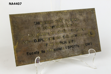
Brass commemorative plaque. This Tree was planted in commemoration of 100 years of State Education and completion of the school oval 17th March 1973. Eucalyptus Maculata (Spotted Gum)As aboveschool, equipment -
 Ballarat Heritage Services
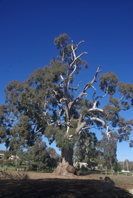
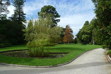
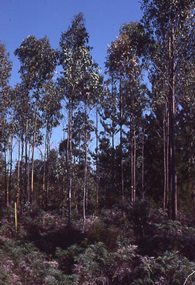
Photograph - Photograph - Colour, Clare Gervasoni, Big Tree, Guildford, Victoria, 2017, 16/07/2017
The Big Tree is listed a a tree of State significance on the National Trust's Register of Significant Trees of Victoria for its outstanding size, curious fusion of branches, as an outstanding example of the species and as an important landmark.A number of colour photographs of Guildford's Big Tree - a River Red Gum (Eucalyptus camaldulensis). The tres is believed to be one of the largest examples of the species in Victoria, and has been recorded as having a height of 30 metre, a canopy spread of 34 metres, and a trunk circumference of 9.35 metres. The tree was already an ancient giant when white settlers first arrived in the 1840s. On Saturday evening, February 28th 2015, just as dusk was falling, Guildford was hit hard by tornado-like winds, felling the big cottonwood tree down by the river, and tearing limbs from the iconic Big Tree, reducing it by an estimated one third. The debris has been cleared since then and the tree seems to have survived its ordeal, though its size is certainly diminished.big tree, guidlford, river red gum -
 Bendigo Historical Society Inc.
Newspaper - LYDIA CHANCELLOR COLLECTION: TREES, 1960's
A box with a picture of trees on the front. It contains cuttings of articles relating to trees taken from 'The Bendigo Advertiser' 1955-1963. It also includes pictures of trees from magazines in the 1960s and a book titled 'Australian Eucalyptus.' The book was compiled by B.G. Mulllins. Published by Horwitz Int.'Australian Eucalyptus. By B.G. Mulllins. Published by Horwitz Intsciences, general, trees, lydia chancellor, collection, trees, environment, heritage, nature, place, sciences -
 Bendigo Historical Society Inc.
Document - PETER ELLIS COLLECTION: LETTER, 20th August, 1980
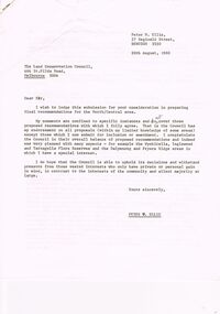
Letter (11 Pages) from Peter N Ellis to the Land Conservation Council. Letter refers to proposed State parks - Kamarooka State Park and Whipstick State Park. other areas mentioned are the Wellsford Forest, Mandurang Forest, Lockwood Forest, Waanyaraa, Fryerstown, Whipstick Hill (Flagstaff Hill) and Black Rock. Other areas are Wellsford/Axedale Forest, Sugarloaf Range, Mandurang Forest, Main Coliban Channel, Lockwood Forest, Tarnagulla/Dunolly Forest, Fryerstown, Seven Sisters (between Huntly and Goornong). Plant and tree life in each area is mentioned including the cutting of eucalypt for the production of Eucalyptus oil.person, individual, peter ellis oam, peter ellis collection, land conservation council, kamarooka state park, whipstick state park, eucalyptus oil production, fncv victorian naturalist, d j paton, bendigo field naturalists club, wellsford forest, mandurang forest, main coliban channel, lockwood forest, waanyaras, fryerstown, whipstick hill (flagstaff hill), parish of neilborough, old underground water race, puddling machine, srwsc -
 Buninyong & District Historical Society
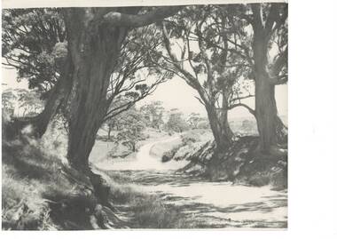
Photograph - B/W photograph, Bon Strange (nee Lorensini) photographer, View from Mount Buninyong, c1935
... eucalyptus landscape trees "Bon thinks the same big tree on left ...Record of landscape 1930'sRecord of landscape 1930'sBlack and white photograph of view from Mount Buninyong through eucalyptus tress, road winding downhill, mid 1930's."Bon thinks the same big tree on left was painted by John Rowell in his painting in the Art Gallery." mount buninyong, eucalyptus, landscape, trees -
 Friends of Westgarthtown
Bottle
Clear glass bottle oval shaped. Embossed on back J. Bosisto Richmond. Paper label on front reads "Bossisto's Parrot Brand Oil of Eucalyptus".Paper label on front of bottle reads " A valuable external remedy for rheumatism lumbago, sciatica, sprains, chilblains, whooping cough, Croop, asthma, bronchitis, sore throat and all other painful afflictions whenever stimulating applications is required. The oil taken internally in five to six drop doses on loaf sugar and inhaled over hot water is recognised as many medical authorities as almost a specific in the treatment of common cold and influenza. A few drops sprinkled on a cloth and suspended in a sick room renders the air refreshing. Rubbed lightly on the face and hands it prevents attacks from mosquitoes. Full directions for use on full wrapper around bottle. Bosistos Eucalyptus Oil is the genbuine essence of the Tree distilled from E. Ihumosa and other speicies best known to contain the medicial purposes of the oil in the most perfect combination for general medical use. Embossed on back of bottle reads J. Bosisto Richmond.medicine, first aid, bosisto, richmond, eucalyptus, domestic, remedy, oil. -
 University of Melbourne, Burnley Campus Archives
Photograph - Black and white print, 395/31A
"Original residence of Curator of Egg-Laying Competition. Spindly tree close to house is Eucalyptus citriodora planted by Mrs. Macauley's mother Mrs. Roberts." THKcurator, egg laying, competition, eucalyptus, mrs. macauley, mrs. roberts, e. m. gibson collection -
 University of Melbourne, Burnley Campus Archives
Album - Digitised, Joanne Morris, Visit to Burnley April 2014, 2014
Collection of digitised photographs taken in preparation for the Class of 1973 Reunion in 2014. Garden views and buildings. Donated by Joanne Morris, former student, in June 2014. See Digitised photos- Garden Views folder- Visit to Burnley April 2014. (1) Luffmann Ponds. (2) Administration Building. (3) Emily Gibson Beds and Ginkgo biloba. (4) Looking towards Native Garden. (5) Oak tree. (6) Looking towards Rose Garden. (7) Looking towards Stream Garden and Fern Garden. (8) Looking towards Rose Garden. (9) Plaque at entrance to Field Station. (10) New gates at entrance to Field Station donated by the Friends of Burnley Gardens. (11, 12) Field Station. (13) Plaque in Herb Garden commemorating Enid Carberry. (14) Fountain in Herb Garden commemorating Enid Carberry. (15) Forestry Building. (16-18) Inside Forestry Building. (19) Sugar Gum Table Setting donated by the Friends of Burnley Gardens. (20) Plaque on Sugar Gum Table commemorating Geoff Olive. (21, 22) View of Luffmann Ponds and Summer House. (23) Plaque at Luffmann Ponds. (24) Luffmann Ponds. (25) View of former Egg-Curator's Residence from Nursery. (26) Back of Nursery. (27,28) The Burnley entry for the Melbourne International Flower and Garden Show 2014. (29) Back of Administration Building. (30) Plant Science Laboratories. (31) Student Amenities Building. (32-34) Plant Science Laboratories. (35) Citriodora Court. (36) Eucalyptus maculata at entrance to Native Garden. (37) Native Garden, James Hitchmough Grasslands. (38) Garden view. (39) Inside the Hall. (40,41) Roof Garden. (42,43) Library. (44-50) Views of the Quad and classrooms. (51) Dairy. (52) Building 904,(Centre for Urban Horticulture) now Waterway Ecosystem Research Group. (53) Yarra Boulevard entrance.class 1973, class reunion, garden views, buildings, joanne morris, students, luffmann ponds, administration building, emily gibson beds, ginkgo biloba, native garden, oak tree, rose garden, stream garden, fern garden, field station, friends of burnley gardens, plaques, herb garden, enid carberry, fountain, forestry building, sugar gum table, geoff olive, summer house, egg-curator, residence, nursery, melbourne international flower and garden show, 2014, plant science laboratories, student amenities building, citriodora court, eucalyptus, james hitchmough grasslands, roof garden, library, quad, classrooms, dairy, centre for urban horticulture, waterway ecosystem research group, yarra boulevard entrance -
 University of Melbourne, Burnley Campus Archives
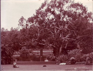
Photograph - Sepia print, View of Botanic Gardens, Unknown
... trust significant tree register eucalyptus camaldulensis royal ...This tree is included in the Degree Horticultural thesis of Christine M. Hill, 1991 wherein a full page of information is provided - Tree 29.Sepia photograph. View of lake with 2 children on the lawn. Eucalyptus camaldulensis is the "Lion's Head Tree" on the National Trust Significant Tree Register. Photographs B91.409 to B91.417 appear to have come from the same photograph album.lake, lawn, lion's head tree, national trust significant tree register, eucalyptus camaldulensis, royal botanic gardens, botanic gardens -
 University of Melbourne, Burnley Campus Archives
Photograph - Colour prints, John Rayner, Trees, 1978
... Boulevard Richmond melbourne eucalyptus cedars trees (1) Eucalyptus ...(1) Eucalyptus cladocalyx, Sugar Gum (2) Cedrus deodara, Himalayan Cedareucalyptus, cedars, trees -
 University of Melbourne, Burnley Campus Archives
Album - 35mm Colour slides, Arboriculture Diseases, 1980-1981
Box of slides labelled "P.C. & Ben A?" Appear to be photographs of pests and diseases of pine trees - Phytophthera cinnamomi? 1 labelled "Sirex" Sirex Wood Wasp?" Mostly May 80 and Apr 81. Other labels: E. Smithii Gully Peppermint Orbost Vic, Portable ...? built Dec 93, Kew Swift & Building Melb Water.sirex wood wasp, phytophthera cinnamomi, arboriculture, excursion, pests, eucalyptus smithii, gully peppermint, orbost, diseases, kew swift -
 University of Melbourne, Burnley Campus Archives
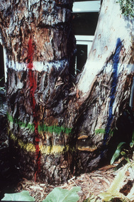
Album - 35mm Colour slides, E. mannifera Trial, 2000
... Boulevard Richmond melbourne trials 2000 eucalyptus mannifera trees ...18 slides labelled "E. mannifera Trial". Dated June 2000. Trees with coloured bands painted on them. Labeled cross sections of wood. Fungi.trials, 2000, eucalyptus mannifera, trees, arboriculture -
 Tarnagulla History Archive
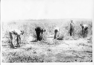
Photograph of Eucalyptus harvesters, Eucalyptus harvesters, circa 1890-1920
... eucalyptus distilling forestry plants trees Monochrome photograph ...Murray Comrie Collection. This is a reasonable copy of an older original. Copy probably made by Murray Comrie in the 1960s. Monochrome photograph of men harvesting Eucalyptus foliage, possibly at or near Arnold West.arnold west, industries, agriculture, eucalyptus, distilling, forestry, plants, trees -
 Tarnagulla History Archive
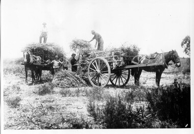
Photograph of Eucalyptus harvesters with wagons, Eucalyptus harvesters with wagons, circa 1890-1920
... eucalyptus distilling forestry plants trees horses transport ...Murray Comrie Collection. This is a reasonable copy of an older original. Copy probably made by Murray Comrie in the 1960s. Monochrome photograph of men loading Eucalyptus foliage onto two horse-drawn wagons, possibly at or near Arnold West.arnold west, industries, agriculture, eucalyptus, distilling, forestry, plants, trees, horses, transport -
 Eltham District Historical Society Inc
Photograph - Digital Photograph, Marguerite Marshall, Hawthorn hedges, Eltham-Yarra Glen Road, Kangaroo Ground, 3 October 2006
Hawthorn hedges are important reminders of Kangaroo Ground's Scottish heritage. They are Registered on the Victorian Heritage Register. They are "historically significant because the planting of hawthorn hedges reflects the adoption of Eurorpean farming techniques by the Kangaroo Ground population in the period following settlement and because the grid pattern of paddocks that the Hawthorn hedges define is very different to today's farm landscapes." Covered under Heritage Overlay, Nillumbik Planning Scheme. Published: Nillumbik Now and Then / Marguerite Marshall 2008; photographs Alan King with Marguerite Marshall.; p21 Hawthorn hedges bordering Kangaroo Ground’s gently rolling farmlands are important reminders of its Scottish heritage and are rare so close to Melbourne.1 As early as the 1840s newly arrived farmers from Scotland planted hawthorn hedges around their properties, to protect crops from the numerous kangaroos and wallabies. Many of these hedges survive today. These farmers had the good fortune to settle some of the most fertile land available for cropping in the Colony of Victoria. At that time the black volcanic soil could sustain an amazing two crops a year. By the mid 1850s, 500 acres (202ha) of wheat were growing in Kangaroo Ground. But the crops were threatened by kangaroos, which were so plentiful, that Surveyor-General, Robert Hoddle, named the district Kangaroo Ground in 1838. As post-and-rail fences proved inadequate barriers for the bounding kangaroos, the Scots planted hawthorn hedgerows as they had done in Scotland. Some also used the hedges to net birds, presumably for the table. Interestingly the farmers in the bordering townships of Panton Hill and Christmas Hills, did not plant hawthorn hedges around their properties. Perhaps it was because by the time they settled in the 1860s and 1870s most of the wildlife had been gunned down by residents.2 The canny Scots planted the hedges on public land outside their own farms, as the hedgerows could spread to about five yards (five m) in width. With this impenetrable barrier Kangaroo Ground’s industrious farmers flourished to gain the economic power that saw the Shire of Eltham governed from Kangaroo Ground for 79 years (1858-1937). The Scots jealously guarded their land, so hard to get in Scotland. That is why they refused to release any of it ‘for local roads to follow easier grades as was the case in surrounding districts where roads generally followed ridgelines or streams’.3 Instead the roads were built in accordance with the magnetic bearings of their first survey in 1847 whether that suited the steep topography or not. This could force traffic to diverge when wet through Greensborough and Diamond Creek. Until 1921, the Eltham-Yarra Glen Road beside Wellers Restaurant, ‘dipped down into the upper reaches of Stony Creek’.4 Later some corners were compulsorily cut for the increasing motor traffic. As late as the 1960s, corners were cut to form sweeping curves above and alongside the Kangaroo Ground Cemetery and opposite the Emergency Operations Centre. In the latter case, the farmers – understanding their hedgerows as important heritage – insisted upon their reinstatement to conform to the altered road alignment. Kangaroo Ground’s ancient manna gums also point to the district’s history and to that of the hedgerows. The Aboriginal people had transformed the original forests into grasslands with the fires they lit to attract kangaroos, (which the Scots were to exclude by planting hedgerows). But the Wurundjeri hunters left the gums (Eucalyptus vimminalis cygnetensis), on the grasslands as ‘stalking trees’ to hunt kangaroos. The hawthorn hedges in Kangaroo Ground were neglected for around 60 years from about the middle of the 20th century. Bushfires had created gaps and the hedgerows were not trimmed. Then in late 2005, local historian Mick Woiwod, formed a group to lobby the Nillumbik Shire to restore the hedges, which could last for many centuries. Some hedges in parts of Britain date back to AD 800.5 Although the original Scottish farmers have gone, the hedges are a reminder of when they flourished in the district, which has changed little in 150 years.This collection of almost 130 photos about places and people within the Shire of Nillumbik, an urban and rural municipality in Melbourne's north, contributes to an understanding of the history of the Shire. Published in 2008 immediately prior to the Black Saturday bushfires of February 7, 2009, it documents sites that were impacted, and in some cases destroyed by the fires. It includes photographs taken especially for the publication, creating a unique time capsule representing the Shire in the early 21st century. It remains the most recent comprehenesive publication devoted to the Shire's history connecting local residents to the past. nillumbik now and then (marshall-king) collection, eltham-yarra glen road, hawthorn hedgerow, kangaroo ground -
 Merbein District Historical Society
Photograph, Girl near River Red tree Merbein, c.1950's
merbein girl, eucalyptus -
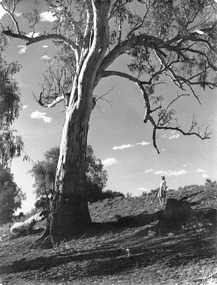
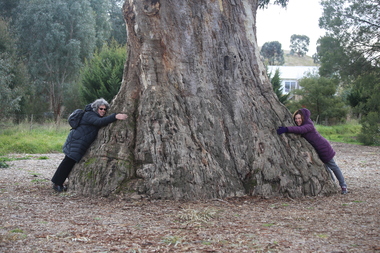 Ballarat Heritage Services
Photograph - Photograph - Colour, Clare Gervasoni, Clare Gervasoni and Ann Gervasoni at the Guildford Big Tree, 2017, 16/07/2017
The Big Tree is listed a a tree of State significance on the National Trust's Register of Significant Trees of Victoria for its outstanding size, curious fusion of branches, as an outstanding example of the species and as an important landmark.A photographs of Guildford's Big Tree - a River Red Gum (Eucalyptus camaldulensis). The tre-es is believed to be one of the largest examples of the species in Victoria, and has been recorded as having a height of 30 metre, a canopy spread of 34 metres, and a trunk circumference of 9.35 metres. The tree was already an ancient giant when white settlers first arrived in the 1840s. On Saturday evening, February 28th 2015, just as dusk was falling, Guildford was hit hard by tornado-like winds, felling the big cottonwood tree down by the river, and tearing limbs from the iconic Big Tree, reducing it by an estimated one third. The debris has been cleared since then and the tree seems to have survived its ordeal, though its size is certainly diminished.big tree, guidlford, river red gum -
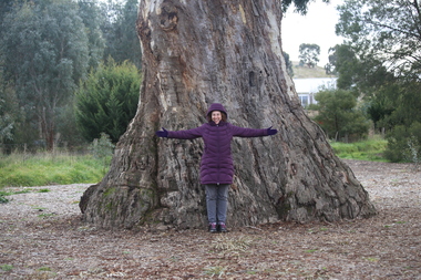 Ballarat Heritage Services
Photograph - Photograph - Colour, Clare Gervasoni, Ann Gervasoni at the Guildford Big Tree, 2017, 16/07/2017
The Big Tree is listed a a tree of State significance on the National Trust's Register of Significant Trees of Victoria for its outstanding size, curious fusion of branches, as an outstanding example of the species and as an important landmark.A photographs of Guildford's Big Tree - a River Red Gum (Eucalyptus camaldulensis). The tre-es is believed to be one of the largest examples of the species in Victoria, and has been recorded as having a height of 30 metre, a canopy spread of 34 metres, and a trunk circumference of 9.35 metres. The tree was already an ancient giant when white settlers first arrived in the 1840s. On Saturday evening, February 28th 2015, just as dusk was falling, Guildford was hit hard by tornado-like winds, felling the big cottonwood tree down by the river, and tearing limbs from the iconic Big Tree, reducing it by an estimated one third. The debris has been cleared since then and the tree seems to have survived its ordeal, though its size is certainly diminished.big tree, guidlford, river red gum -
 University of Melbourne, Burnley Campus Archives
Photograph - Black and white prints, Publicity Branch Victorian Department of Agriculture et al, Plants, 1957-1963
Black and white photographs, many labelled. Flowers, trees, propagation, signs, etc. Some for Journal articles. Publicity Branch Victorian Department of Agriculture: (1) 2 copies, C.1768A "Camellias Geraniums." (2) c.1262D "Anemone japonica." ((4) c.1262K "Hibiscus Wilder's White." (5) "Peace." (7) D521A Fruit tree. (8) c.1262E "Helenium autumnale." (9) c.1262I "Gerri Hock?" (12) c.1262F "Golden Ash. " (13) Struck cuttings 05 7.6.57. (14) "Kumquat." (15) Path to Principal's Residence. (16) A479 "Thujopsis dolobrata. Make an excellent tub specimen of the spreading type." (17) A477 "Aucuba japonica variegata. A very good foliage shrub for tubs. Sept '63 Jnl." (18) Struck cutting. (19-22) Arum, different views. (23) 2 copies ? (24) "June garden notes," small tree with roots. (25, 26) Different views ? (27)Pittosporum crassifolium. (28) "For Dec article (This is the one to use) Polyanthus are attractive & easily managed pot plants. (29) 2 copies ? (30) ? (31) Tubers. (32) "Oct Jnl" "Dividing the tubers. This is necessary to ensure that one eye is left etc." (33) Divided tuber. (34) Aucuba in pot. (35) ? (36) "Thuja plicata aurea a good tub plant of pyramid form." (37) "Buxus sempervirens. he English Box makes a neat, compact, low hedge." (38) "Cupressus torulosa is useful for a high narrow hedge for screening." (39) Sign giving information about different fertilizer treatments. (40) Sign comparing yield of Jonathons & Democrats with fertilzers. (41) "Russell Lupins." (42, 43) Different views ? (44) Soil profile in hole. (45) "Cyclamen is a good subject flowering over winter period." (46) "Cyclamen." (47) "Chabbads? & Malmaisons are suitable for bedding & make good cut flowers." (48) A478 "Seedlings." (49) A487 2 copies Roses in vase. (50) C.1767.E "Angophora 5-6 years." (51) C.1769.C "Jan '60 Jul. Ginko biloba Maidenhair Tree." (52) C.1768.C "Thuja plicata aurea, Golden Willow, Pinus radiata." (53) C.1762.I Vegetables. (54) A512 ?. (55) C.1767.C 2 copies "Eucalyptus torquata." (56) C.1769C 2 copies "Eucalyptus ficifolia." (57) C.1769.C 2 copies "Callistemon lanceolata( Bottle Brush.) (59) C.1769.B 2 copies "Pepperomias." (58) C.1769.F 2 copies "Melaleuca styphelioides (Paper Bark Tree.) (60) C.1769.D 2 copies "African Violets." (61) C.1768.F 2 copies "Pelargonium." (62) C.1768.B 2 copies "Tilia europea (Linden Tree.) Department of Agriculture Biology Branch: (6) Neg No 06 24.11.59 "A struck cutting of Rhododendron var. Alice. For a rhododendron this popular & beautiful variety strikes readily." (13) 05 5.6.57 Struck cuttings. No provenance: (3) "Araucaria excelsa, ?, ?, Metrosideros tomentosa." (10) "Thuja rheingold." (11) "Border of Geraniums (zonal Pelargoniums." (14) "Kumquat." (15) Path to Principal's Residence." (18) Struck cuttings. (19-22) Different views of Arum. (23) 2 copies ? (24-26) "June garden notes." Small tree with roots. (27) "Pittosporum crassifolium." (28) "For Dec article (This is the one to use) Polyanthus are attractive & easily managed pot plants." (29) 2 copies ? (30) ? (31) Tubers. (32) "Oct Jnl Dividing the the tubers. This is necessary to ensure that one eye is left etc." (33) Divided tuber. (34) Aucuba in pot. (35) ? (36) "Thuja plicata aurea a good tub plant of pyramid form. (37) "Buxus sempervirens. The English Box makes a neat, compact, low hedge." (38) Cupressus torulosa is useful for a high narrow hedge for screening." (39) Sign in Orchard giving information about different fertilizer treatments. (40) Sign in Orchard comparing yield of Jonathans and Democrats with fertilizers used. (41) "Russell lupins. (42-43) Different views ? (44) Soil profile in hole. (45) "Cyclamen is a good subject flowering over Winter period." (46) Cyclamen. (47) "Chabbads? & Malmaisons are suitable for bedding & make good cut flowers." flowers, trees, propagation, signs, camellias, geraniums, anemone japonica, hibiscus, fruit trees, principal's residence -
 Eltham District Historical Society Inc
Work on paper - Folio, Register of Significant Trees, Shire of Eltham, c.1993
... arthurs creek road, blue gum (eucalyptus globulus), canary... road, hurst tree, hurstbridge, ironbark (eucalyptus tricarpa ...In 1983, the National Trust advised the Shire of Eltham that it was investigating a number of trees within the shire which had been nominated for recording the Register of Significant Trees of Victoria. The trees involved were described in the Shire of Eltham Historical Society Newsletter No. 29, March 1983 as follows:- 1. Eucalyptus melliadora (Yellow box) . a) An outstanding mature specimen 42 metres high in Laughing Waters Road, Eltham. b) Another mature specimen in Arthurs Creek road, Hurstbridge is reported to be the tree under which the bushranger Robert Bourke was tied after he shot and killed Henry Hurst in 1866 . 2. Quercus robur (English Oak). a) "Donaldson's Oak", Donaldsons Road, Kangaroo Ground was planted by John Donaldson from seed collected from Windsor Great Park in 1878. b) "Wippells Oak". This now misshapen tree is located on the St. Andrews Road near the Kangaroo Ground Fire Station. Its origins may have been similar to Donaldson's Oak, and as a young tree it apparently slipped from higher up the hill during wet weather. Both oaks are of local historical importance. 3. Eucalyptus globulus (Blue Gum). A large mature specimen at the corner of the Kangaroo Ground-St. Andrews Road and Bakehouse Road, Panton Hill. 4. Plantanas acerifolia (Plane tree) A number of trees forming the Avenue of Honour to Eltham's First World War soldiers along Main Road between Dalton and Pitt Streets, Eltham. 5. Pinus canariensis (Canary Island Pine), Pinus pinea, (Stone pine) and Cedras altlantica, (Cedar) These trees are located at the Hurst family graves in the grounds of the Hurstbridge Pre-school Centre. In 1991 the Shire of Eltham introduced controls into its planning scheme to protect sites of architectural, historic or conservation interest and significant trees. The controls were approved by the Minister for Planning and Housing. As advised in the Shire of Eltham Historical Society Newsletter No. 78, May 1991, a planning permit is required to demolish or alter any listed building or to destroy, lop or remove any listed tree. Provision is made for comments to be obtained from the National Trust or Historic Buildings Council in considering any applications. The buildings and trees listed were: Buildings: 250 Bolton Street Eltham (former Walter Withers home) "Rosehill" - Bonds Road Lower Plenty St Andrews Church of England - St Andrews "Montsalvat" - Hillcrest Avenue Eltham St Margarets Church and former vicarage - Pitt Street Eltham Presbyterian Church - Kangaroo Ground Parks and Environment Office (former police quarters) Main Road Eltham Former Court House - Main Road Eltham "Shillinglaw Cottage" - Main Road Eltham "The Robins" - Kangaroo Ground Road Warrandyte Trees: "Donaldsons Oak" - Donaldsons Road Kangaroo Ground Yellow Box - Laughing Waters Road Eltham Yellow Box - Arthurs Creek Road Hurstbridge Wippells Oak - St Andrews Road Kanqaroo Road Pines and Cedar - Hurst family cemetery Greysharps Road Hurstbridge Yellow Box - Parsons Road Eltham A large Blue Gum at Panton Hill has been listed but has recently died (1991). In 1993 work by Council Parks and Environment staff and volunteers resulted in the preparation of a Significant Tree Register listing forty-one trees or groups of trees. According to Shire of Eltham Historical Society Newsletter No. 91, March 1993, a similar number remained to be assessed for inclusion in the register. There is a wide range of indigenous and planted trees on private and public land and extending through the Shire of Eltham from Lower Plenty to Kinglake. Most can be viewed from publicly accessible locations. The Significant Tree Register lists 41 trees or groups of trees throughout the Shire. It contains a wide range of naturally occurring and planted trees. They have been assessed according to eleven criteria including size, age, rarity, historical value and the like. The list includes large old Red Gums at Lower Plenty, historic Oaks at Kangaroo Ground and Mountain Ash at Kinglake. The register includes a set of slides showing each tree. Garry Bartlett of the Council's Parks and Environment Section and Faye Shepherd were extensively involved in establishment of the register (Newsletter No. 93, November 1993). In 1999 Niliumbik planners prepared an amendment to the Planning Scheme to provide protection for approximately 200 of the places listed in the heritage studies and also in the Significant Tree Register commenced by the Eltham Council (Eltham District Historical Society Newsletter No. 127, July 1999. In 2004, The Register of Significant Trees was presented to the Eltham District Historical Society by Nillumbik Shire Council as part of a wider collection of of its memorabilia of the former Eltham Shire Council (EDHS Newsletter No. 159, July 2004. Album of loose handmade paper sheets contained within a handmade slip cover constructed of handcrafted card with encapsulated flora material (flowers, vines, ferns) and tinted. Each page also contains an embedded/adhered fern leaf also tinted with lacqueur or similar, text as appropriate in ink by hand calligraphy. Each page also has a white protective sheet cut to size and adhered to back surface with sticky tape and folded over face of page. Pages variously have photographs and coloured masks adhered with a gum resin. Over time much of this resin has let go and photos/masks have been reattached using acid free archival safe adhesive. 15 pages 41 x 29 cm inclusive of 3 blank pages. Slip case 42 x 30 x 1 cm; face cover of slip case has broken off at left hand margin as insufficient depth/flexibility for contents.arthurs creek road, blue gum (eucalyptus globulus), canary island pine (pinus canariensis), couties road, donaldsons oak, donaldsons road, eltham, english oak (quercus robur), eucalyptus melliodora, graysharps road, hurst tree, hurstbridge, ironbark (eucalyptus tricarpa), ironbark hill, kangaroo ground, kangaroo ground-kinglake road, laughing waters road, panton hill hotel, panton hill, parsons road, significant trees register, sonia van bodegraven, sonjart, stone pine (pinus pinea). atlantic cedar (cedrus atlantica), wippells oak, yellow box gum (eucalyptus melliodora), yellow box gum -
University of Melbourne, Burnley Campus Archives
Album - Black and white and colour slides, Teaching Horticulture, 1952-1969
Large collection of slides used for teaching Horticulture. Difficult to identify whether they were taken at Burnley. Labelled and numbered 1-2501. Some dated but spread over 1950's to 1960's. Also 57 slides similar to 1-50 labelled but not numbered. Some photographs have been catalogued elsewhere. Missing numbers have been mixed up with other photographs. 1-50 Mostly fungal diseases. 57 slides not numbered - fungal diseases. 1-29 Mostly mosses. 31-41 Mostly liverworts and hornworts. 43-60 Ferns. 61-73 selaginella. 75-84 Ferns 85-114 Gymnosperms 115-1236 Miscellaneous 117-141 Angiosperms 142-294 Biology 296-307 Orchidaceae 311-316 Acacias 796-841 Trees 866-889 Roses 955-984 Eucalyptus 1009-1046 Greenhouse. 1052-1086, 1097-1152 Propagating fruit trees. 1087-1090 Cacti. 1151-1187 Planting and pruning principles. 1196-1218 Orchard, Nursery. 1211 June 1956. 1215 8/3/57. 1228-1258 Orchard Management. 1263-1345 Crafting and reworking. 1346-1373 Bulk handling. 1390-1400 Leaf scorch. 1424-1472 Vegetables.1473-1512 Potatoes, Research farm Toolangi 2/54. 1514-1686 Garden Design. 1688-1695 Cow Paddock, and in flood. 1958, Students. 1795-1798 P.R.I. 1823 Rolling the Surface (New Admin Building)1828-32.1831-1838 Beaumaris Feb 1958.1840-1846 P. Vejjajiva's Farewell 23.2.1958. Pruning Day 2/7/60. 1977-1990 Genetics. 1991-2018 Weeds. 2020-2-50 Erosion. 2023 10/65 and soil conservation. 2072-2136 Fertilizers. 2144-2149 Rhizobia 1950's. 2155-2157 Lime. 2160-2228 Plough, Cultivators, etc. 2246-2296 Tatura 12/59. 2301-2237 Beef and Dairy Cattle. 2338-2354 Sheep. 2355-2372 Crops. 2357-2363 1952. 2364 1958. 2373-2397 Fodder conservation 1952-1956. 2398-2411 Fences. 2398-2406 11/52. 2418-2248 Longerenong Field day 1964. 2451-2455 Boom Sprayer 1960. Glasshouse Wagga Agric College Oct 69. Apr 84 M3 16-18 Cultivator? 2458-2483 Hydraulics,Power Farming Dec 1966-Mar 1967. 2487-2488 Hydraulics Vane Pump Construction. 2491-2500 Mechanics. 2501 Rack Shaker. Extra 13 Pond life. Some slides see B18.0001: 1676, 1684, some between 1711-1792, 1881, some between 1911-1953.Not scanned yet.teaching, horticulture, greenhouse, propagation, pruning, cacti, planting, orchard nursery, orchard management, grafting and reworking, potatoes, toolangi, garden design, lagoon paddock, beaumaris excursion, p.vejjajiva, lagoon paddock in flood, fungal diseases, genetics, weeds, erosion, fertilizers, rhyzobia, lime, cultivation, tatura, cattle, sheep, crops, fodder, fences, hydraulics, mechanics, longerenong, cow paddock, plough, cultivator, boom sprayer, wagga agricultural college, vane pump -
 Bendigo Historical Society Inc.
Slide - Peter Ellis Collection, the Whipstick and Eucalyptus Oil Production, c1970-1972
When the numerous gold mines declined in production, the eucalyptus oil industry became an important source of work. The first eucalyptus oil producer in Bendigo was a chemist called Richard Sandner who operated a plant and refinery in Bridge Street from 1876. By 1900, many other distillers operated on the northern edge of Bendigo and in the Whipstick. In 1926, the Forest Commision established a eucalyptus distillery at Gunyah in Wellsford State Forest. See the Wellsford Forest Note for more information. Today, there are just two eucalypt distilleries operating in Bendigo. Most of the world’s eucalyptus oil is now produced overseas. Peter Ellis Collection: eight slides of Whirrakee Wattle regeneration near Bagshot, Eucalyptus History museum, Ruedin's Steam Traction engine, Eucalyptus oil condensor and a Mallee roller to rip out the eucalytpus trees. Peter was a chemistry lecturer at the Bendigo Institute of technology.history, bendigo, peter ellis collection, bendigo institute of technology, b.i.t., whipstick bendigo, bendigo state forests, eucalyptus oil, malle roller, whirrakee wattle, bagshot, steam traction engine, eucalyptus oil condensor