Showing 1617 items matching "farming"
-
 Phillip Island and District Historical Society Inc.
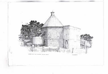
Drawing, Chicory kilns by D. Leversha
Chicory farming was popular on the Island. Chicory was sent to Melbourne to be mixed with coffee, especially during WW2Historical2 copies of black & white sketches of chicory kilns drawn by D. Levershachicory farming, chicory kilns, f. b. morgan-payler, d. leversha -
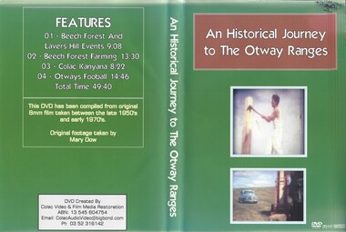 Otway Districts Historical Society
DVD, An Historical Journey to the Otway Ranges
Beech Forest and Lavers Hill Events / Beech Forest Farming / Colac Kanyana / Otway FootballHome videos of People and Events in the Otway Ranges. Taken between the late 1950's and early 1970s. Original footage taken by Mary Dow.beech forest / lavers hill / otway football -
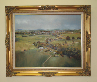 South Gippsland Shire Council
Painting. Oil, Leongatha Landscape
Framed oil painting titled: "Leongatha Landscape" painted by Harris Smith. Features scene of farming property in the foreground and township of Leongatha in the distance. Rolling hills, flora, buildings and sky. Gold decorative frame with cream textured vinyl window mount. Painted in shades of browns, greens, blues and yellows. -
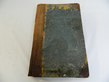 Kiewa Valley Historical Society
Ledger - Tawonga Store 1915 to 1920s, c1915
The Tawonga Store was a general store in the Upper Kiewa Valley providing for a farming community. This store which had a variety of items was the main store for many of the farming families who would travel on horse and cart to make weekly trips to the store for supplies. This ledger was used by the owner of Tawonga Store to keep a record of items sold and to whom. George Potter owned the Tawonga Store before 1920. Whit Potter, George's son, worked with his father for many years. Attached to this ledger is a sheaf of letters which were sent to the Potter's, which are relevant to the day to day operation of a General Store. The ledger gives a comprehensive list of what type of items the residents of the Kiewa Valley purchased during this period, thus has great historical significance. It is well provenanced and very good interpretive capacity. Green linen covered cardboard cover. Brown (leather look) paper spine. Inside cover is red and green marbled paper. It has an alphabetic index at front. 262 ledger pages, the edges of which have been marbled.Ledger - printed on a red square embossed in gold on a brown thick paper spinetawonga, general store, book-keeping, ledger, george potter, whit potter -
 Narre Warren and District Family History Group
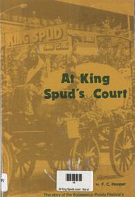
Book, FC Hooper, At King Spud's Court: the story of the Kooweerup Potato Festival's first ten years (1972-1982), 1982
A chronicle of the first decade (1972–1982) of the Kooweerup Potato Festival in Victoria, Australia. It delves into the history, community involvement, and cultural significance of this unique festival, which celebrated the region's rich potato farming heritage.108 p.; 22 cmnon-fictionA chronicle of the first decade (1972–1982) of the Kooweerup Potato Festival in Victoria, Australia. It delves into the history, community involvement, and cultural significance of this unique festival, which celebrated the region's rich potato farming heritage. koo wee rup potato festival, koo wee rup (vic.), kooweerup (vic.) -
 Kiewa Valley Historical Society
Papers - Memoir
Mary was born on 6th May 1939 and describe dairy farming in the Kiewa Valley throughout the years to c2020A handwritten family history of dairying in the Kiewa Valley consisting of 8 pages written with blue biro. A memoir by Mary Cardwell nee Creamer 'My early days of dairying in Kiewa Valley.'All pages are torn at the top.mary cardwell, dairy farming, kiewa valley, women -
 Phillip Island and District Historical Society Inc.
Photograph, Anderson Family, 1869
Brickworks situated on large farming area. Built soon after his arrival on Phillip Island in 1868.Brickworks in rural setting. Slender tree trunks in foreground alongside river. Post and wire fence with slip-rail gate. Large brick building and pavilion-type sheds with canvas awnings. Wood piled up outside.local history, photography, photographs, slides, film, buildings, historic, brick works of robert anderson snr, at phillip island, black & white photograph, mrs emma anderson jacobs -
 Heytesbury District Historical Society Inc.
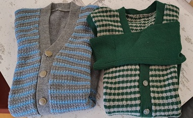
Clothing - Mens Cardigans
The cardigans were knitted by Gavan Deppeler's Grandmother for her husband in the 1930's. They were a farming family.Two hand knitted striped cardigans (2441.1, 2441.2). 1930's. One is dark green and grey stripes, The other is pale blue and grey stripes. Each is a slightly different pattern of narrow stripes with V- neckline and grey buttons down front. They have been well worn with some wear and holes.farming history, cardigans, hand made -
 National Wool Museum
Drawing, Robert Lloyd, Squatter game, 1980
Original concept drawing of the board game Squatter by Mr Robert Lloyd. Squatter is a wool themed board game. With more than 500,000 games sold in Australia as of 2007, it is the most successful board game ever produced in Australia. NOTE THIS IS THE ORIGINAL ATTEMPT /I MADE TO PUT DOWN ON PAPER/ MY ORIGINAL CONCEPT OF/ THE AUSTRALIAN FARMING GAME/ SQUATTER,,(SIGNED) Robert Lloyd/ 24th January 1980 (THIS WAS 6 YEARS BEFORE / PUBLICATION OF ....15/11/91sheep stations - management wool growing squatters, lloyd, mr robert, australia, sheep stations - management, wool growing, squatters, squatter board game -
 Warrnambool and District Historical Society Inc.
Document (collection) - Minute Books and Financial Records of Warrnambool Young Farmers Club, 1970s
Collection of records kept by the Secretary and Treasurer of the Warrnambool Young Farmers Club and handed in by a former memberRecords of a local club (four items)These records are kept in an A4 archival folder in our Collections section in our Archives RoomMinute books and financial records of local club (4 items)farming in the warrnambool districtfarming in the warrnambool district -
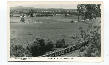 Orbost & District Historical Society
black and white postards, Rose Stereograph Company, 1940s -1950s
These postcards are part of the Rose series of photograph / postcards taken around Victoria. Rose was born in Clunes in 1861 and later worked in his father’s boot-making business in Prahran while studying photography. In 1880 he founded the Rose Stereograph Company and became famous for producing stereographs, or stereoviews, which gave the illusion of being in 3D when seen through a hand-held viewer, a big craze of the era. Rose produced stereoviews of the Western Front during the First World War. In all, he took about 9000 images in about 38 countries. As stereographs lost popularity in the 1920s, Rose switched to production of postcards and decorative cards, and he and the photographers who followed took thousands of scenes around Victoria as well as interstate that became iconic images of Australian life.These postcards are pictorial records of Orbost in the mid 20th century.Postcards such as these were a way of showing the scenic attractions of Orbost to potential tourists.Three black / white postcards of views over the Orbost flats and railway viaduct. 3183.1 is of a railway viaduct in the foreground and farming flats. 3183.2 is a view over the Orbost flats taken from Grandview Lookout. 3183.3 is a view from the Grandview Lookout showing the back of a woman looking across a rail fence. 3183.1 - bottom front - Rose Series P 478 SNOWY RIVER FLATS, ORBOST VIC 3183.2 - bottom front - Rose Series P 49 ORBOST, FROM GRANDVIEW HEIGHTS,VIC 3183.3 - bottom front - Rose Series P 14443 A VIEW FROM THE LOOKOUT, ORBOST, VICpostcards-orbost rose-series orbost-railway-viaduct grandview-lookout-orbost -
 Bendigo Historical Society Inc.
Photograph - The Wilkin Family of Sedgwick - Isaac and Letitia Barcley, 1800s-1900s
The Phil Wilkin Collection contains a series of 11 Items. The related items can be found by clicking on the reference link below. The following history of the Young family and their descendants who lived at the Springs is provided by Phil Wilkin. His Great Grandparents were Frances Young and August Wirth. Phil has also provided notes on the Wilkin Family and some history of the gold mining in Sedgwick. Frances Young's parents Joseph and Margaret Young owned the property called "The Old Place, Preston Vale or Wellington Flat" at Sedgwick near the Springs. Joseph Young owned and Managed the Standard Brewery which was located at Campbells Creek during the late 1800’s early 1900’s. Joseph and Margaret are buried in the Harcourt cemetery. In 1880 August Wirth lived at Mosquito Creek (Lake Eppalock, Victoria) when he married Frances Young. In 1902 they moved to part of Joseph Young's property. They milked cows and sold cattle for a living. One of their children Charles Wirth (Phil Wilkin's Grandfather) bought the land in 1935 after his parents had died. Charles Wirth was a councillor and also was president of the Shire of Strathfieldsaye. The "Old Place" was part of the property owned by members of the family. The old house at the Springs was burnt out by bushfire in January 1944 and much of the stonework was later vandalized by campers. The original Coliban Water Works were designed in 1863 by the Irish engineer Joseph Brady. The system included 70 kilometres of open water channels, aqueducts, syphons and tunnels to carry water (by gravity) from the Coliban River at Malmsbury, north to Castlemaine and Bendigo. Sedgwick is a locality in Central Victoria, Australia. It is located in the City of Greater Bendigo. Facilities include a public hall that opened in 1958 and CFA Rural fire station. It was named Upper Emu Creek until 1901 when it was renamed as Sedgwick after British geologist Adam Sedgwick.Seven historical documents of Isacc and Letitia Barcley who were associated with the Wilkin Family and also with the Springs near Sedgwick. There are 182 photos in this series and can be found at 8683.1 to 8683.11. The series also includes photos of the surrounding farming land and the remains of an old house. There are also some notes on the pioneers of the district.history, bendigo, coliban water, joseph brady, irrigation, the springs, sedgwick, phil wilkin collection, joeseph and margaret young, letitia and isacc barclay -
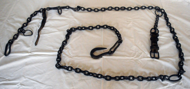 Orbost & District Historical Society
iron chain, First half 20th century
This was probably used on a farming property and would have been attached to various horse-drawn farm implements and machinery.Horses were a vital part of the agricultural industry in Orbost before the mechanisation of farm machinery. This item is associated with that time.A heavy iron chain for attaching to a horse drawn implement. It has a strong hook at one end and a large ring at the other. It has several ring attachments and straps which have been added with wiring.chain farming -
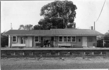 Tatura Irrigation & Wartime Camps Museum
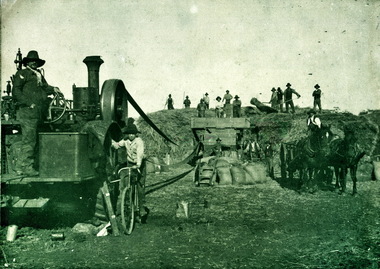
Photograph - Photographs, Railway station
Railway station- eight images|Rail siding at Rosella Factory|Photo No 8 "Better Farming Train" 1928.8 photographs -
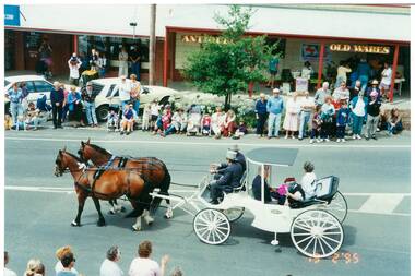 Buninyong & District Historical Society
Photograph - Colour photograph, Buninyong Gold King Festival Feb.Feb.1995, view of Warrenheip Street, Buninyong Gold King Festival Feb.Feb.1995, view of Warrenheip Street
The Gold King festival celebrated transport and notable characters associated with Buninyong's early gold mining and farming days.The Gold King Festival was held for many years and was an important community celebration in the late 20th centuryColour photo, Buninyong Gold King Festival Feb.Feb.1995, view of procession featuring a horse drawn vehicle carrying "Simon de Soza" and Topsy Nevitt (Festival) directorBuninyong Festival, 19 February 1995mining, gold king, de soza, transport, dress, procession -
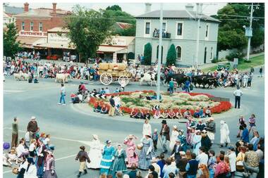 Buninyong & District Historical Society
Photograph - Colour photograph, Buninyong Gold King Festival Feb.Feb.1995, view of Roundabout, Buninyong Gold King Festival Feb.Feb.1995, view of Roundabout
The Gold King festival celebrated transport and notable characters associated with Buninyong's early gold mining and farming days.The Gold King Festival was held for many years and was an important community celebration in the late 20th centuryColour photo, Buninyong Gold King Festival Feb.Feb.1995, view of procession featuring a cattle drawn wagon, livestock and pedestrians in 19th century period dress negotiating the roundabout taken from the Crown HotelBuninyong Festival, 19February 1995mining, gold king, de soza, transport, dress, procession -
 Buninyong & District Historical Society
Photograph - Colour photograph, Buninyong Gold King Festival Feb.Feb.1996, view of new De Soza Stage, Buninyong Gold King Festival Feb.Feb.1996 view of new De Soza Stage
The Gold King festival celebrated transport and notable characters associated with Buninyong's early gold mining and farming days.The Gold King Festival was held for many years and was an important community celebration in the late 20th centuryColour photo, Buninyong Gold King Festival Feb.Feb.1995, view of the opening of the new De Soza stage in De Soza Park BuninyongDe Soza Stage opened 17 February 1996mining, gold king, de soza, de soza stage opening -
 Greensborough Historical Society
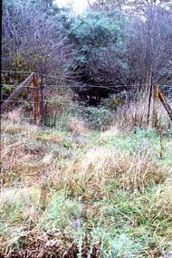
Slide - Photograph, John Ramsdale, Poorly managed farmland: Slide 121, 1990s
Photograph shows a post and wire fence with bushland beyond, and example of poorly managed farmland, thistles in foreground.Part of the John Ramsdale collection of slides and audio visual material.Colour photograph scanned from slide.No caption. Printed maker's mark on slide "Kodak Kodachrome Slide"weeds, farming -
 Orbost & District Historical Society
Photograph - Photograph off Albert Trewin
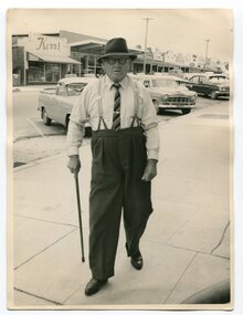
Albert (Abby) Trewin (b.21.03.1876 d. 01.07.1970) was part of the Trewin family who were early settlers at Jarrahmond near Orbost. Albert was born at Kingston near Ballarat, shifted to Jarrahmond where the house was called "Hillview", located 3 miles from Orbost on the B Road. The Trewin selection at Jarrahmond had many big trees on it and because these looked a bit like Jarrah trees from Western Australia, they names their property Jarrahmond (which became the district location and the name of Jarrahmond School). He cleared the land with bullocks, horses, crosscut saws, burned the stumps, burying some logs which were too big to burn. Then they milked cows, planted maize, had pigs, drove the pigs to Bairnsdale or to Waygara (c. 1915 when the train reached Waygara) on a buggy track through the bush. Pigs went to Dandenong Bacon Factory where they were processed into Dandy Ham. This photograph appears to be c.1950s - 1960s.A photograph of one of Jarrahmond's earliest settlers.B/W photograph of a man walking along a footpath. He is wearing a hat and has a walking stick in his right hand. He is wearing braces, white long-sleeved shirt, striped tie, glasses, polished black shoes. Behind him are vehicles and buildings (shops). jarrahmond, farming -
 Ballaarat Mechanics' Institute (BMI Ballarat)
Harvesting
This photograph is from the Max Harris Collection held by the Ballaraat Mechanics' Institute. Please contact BMI for all print and usage inquiries.harvesting, farming -
 Ballaarat Mechanics' Institute (BMI Ballarat)
Harvesting
This photograph is from the Max Harris Collection held by the Ballaraat Mechanics' Institute. Please contact BMI for all print and usage inquiries.harvesting, farming -
 Clunes Museum
Functional object - TRAPPING HOE
Metal head with wooden handleNilagricultural tool, farming -
Tatura Irrigation & Wartime Camps Museum
Book, Register of Lands 54-55, 1955
Records of apportioned Water Rights for farmers in Tatura District 1954-1955Books - Irrigation|Rural Industry - Irrigationirrigation, farming -
 Anglesea and District Historical Society
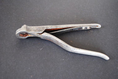
Animal Ear Punch
Animal ear punch (for identification).No discernable markings.ear punch, farming -
University of Melbourne, Burnley Campus Archives
Document, "So you want to buy a farm", c. 1980
Course outline, notes, reference material. Incl. "Marcus Oldham Farm. Part 1. A description, analysis andhistory of the farm" by R.G. Ashby (c. 1979) 64pp.courses, farming -
 National Wool Museum
Photograph
Photograph of hurdles, taken at Mr A. McKenzie's property at Jeparit. Used to make replica hurdles for Gallery One, NWM.farming, national wool museum -
 Rutherglen Historical Society
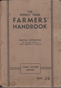
Book, The Weekly Times Farmers Handbook, c1940
Farmers Handbook compiled from articles from practical information from the Rural Section of the Weekly Times. Third Revised Edition.farming, weekly times -
 Tarnagulla History Archive
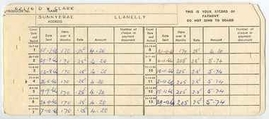
Poultry Levy Collection Booklet, 1960s
Donald Clark Collection.A Poultry Levy Collection Booklet used by Donald Clark of Llanelly in the 1960s.government, farming -
 Tarnagulla History Archive
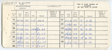
Poultry Levy Collection Booklet, 1960s
Donald Clark Collection.A Poultry Levy Collection Booklet used by Donald Clark of Llanelly in the 1960s.government, farming -
 Mont De Lancey
Book, W. Fream, LL.D, Elements of Agriculture A Textbook, 1892
An English textbook for elementary work on Agriculture adapted for use in rural and other schools and classes.A plain blue hardcover textbook, Elements of Agriculture by W. Fream, LL.D. The spine has the title, author symbol for The Royal Agricultural Society of England, price 2/6 and the publisher John Murray written in gold lettering. it has three parts to the contents, the soil, the plant and the animal along with an Index of plants and a general index. At the back there are listed pamphlets published by the Society and books relevant to the topic. Diagrams, illustrations, tables and charts are included. 450p.non-fictionAn English textbook for elementary work on Agriculture adapted for use in rural and other schools and classes.agriculture, farming