Showing 274 items matching "former shire hall"
-
 Glenelg Shire Council Cultural Collection
Photograph - Photograph - Timber Structure, n.d
... Sourced from Casterton Town Hall (former Shire of Glenelg)... Town Hall (former Shire of Glenelg) Coloured photograph. Same ...Sourced from Casterton Town Hall (former Shire of Glenelg)Coloured photograph. Same structure as 7295. ?inside corner, round poles and sleepers bolted together holding up walls of slats and vertical boards. 7295 -
Glenelg Shire Council Cultural Collection
Photograph, c. 1963
... Sourced from Casterton Town Hall (Former Shire of Glenelg)... Town Hall (Former Shire of Glenelg) Black and white photo. Same ...Sourced from Casterton Town Hall (Former Shire of Glenelg)Black and white photo. Same subject as 7277, 7278, but head and shoulders only -
Glenelg Shire Council Cultural Collection
Photograph, n.d
... Sourced from Casterton Town Hall (Former Shire of Glenelg)... Town Hall (Former Shire of Glenelg) Coloured photograph. Same ...Sourced from Casterton Town Hall (Former Shire of Glenelg)Coloured photograph. Same as 7297 -
Glenelg Shire Council Cultural Collection
Photograph - Photograph - Meeting of Viscount de Lisle, Governor General of Australia and Cr. H. D. Mitchell, Shire President, 25/10/1963
... Sourced from Casterton Town Hall (former Shire of Glenelg)... Town Hall (former Shire of Glenelg) Coloured photograph ...Sourced from Casterton Town Hall (former Shire of Glenelg)Coloured photograph of Viscount de Lisle, Governor General of Australia, being greeted by Cr. H. D. Mitchell, Shire President, at Casterton Town Boundary, on 25th Oct. 1963. The photograph is in a cream folder, with green manufacturer's information -
Glenelg Shire Council Cultural Collection
Photograph - Photograph - Dam at Chetwynd, n.d
... Sourced from Casterton Town Hall (former Shire of Glenelg)... Town Hall (former Shire of Glenelg) Coloured photograph. Fire ...Sourced from Casterton Town Hall (former Shire of Glenelg)Coloured photograph. Fire prevention dam at Chetwynd. -
Glenelg Shire Council Cultural Collection
Photograph, n.d
... Sourced from Casterton Town Hall (Former Shire of Glenelg))... Town Hall (Former Shire of Glenelg)) Back: Round, purple ...Sourced from Casterton Town Hall (Former Shire of Glenelg))Black and white photo. Same as 7256Back: Round, purple, photographer's stamp. -
Glenelg Shire Council Cultural Collection
Photograph - Photograph - Soil Erosion Casterton, n.d
... Sourced from Casterton Town Hall (Former Shire of Glenelg))... Town Hall (Former Shire of Glenelg)) Back: Round, purple ...Sourced from Casterton Town Hall (Former Shire of Glenelg))Black and white photo. Man standing near culvert under road, shows erosion of banksBack: Round, purple, photographer's stamp -
Glenelg Shire Council Cultural Collection
Photograph - Photograph - Glenelg Shire Council administration staff Casterton Victoria, c. 1963
... Sourced from Casterton Town Hall (former Shire of Glenelg)... Town Hall (former Shire of Glenelg) Black and white photo ...Sourced from Casterton Town Hall (former Shire of Glenelg)Black and white photo. Administration staff at Shire of Glenelg, Casterton Victoria. -
Glenelg Shire Council Cultural Collection
Photograph - Photograph - Erosion, Casterton, Victoria, n.d
... Sourced from Casterton Town Hall (Former Shire of Glenelg)... Town Hall (Former Shire of Glenelg) Back: Purple, round ...Sourced from Casterton Town Hall (Former Shire of Glenelg)Black and white photo. Erosion near Casterton.Back: Purple, round, photographer's stamp -
Glenelg Shire Council Cultural Collection
Photograph - Photograph - Casterton, Victoria, n.d
... Sourced from Casterton Town Hall (Former Shire of Glenelg)... Town Hall (Former Shire of Glenelg) Black and white photo ...Sourced from Casterton Town Hall (Former Shire of Glenelg)Black and white photo. Outskirts of Casterton -
Glenelg Shire Council Cultural Collection
Photograph - Photograph - Casterton, Victoria, n.d
... Sourced from Casterton Town Hall (Former Shire of Glenelg)... Town Hall (Former Shire of Glenelg) Back: Black stamp - 003755 ...Sourced from Casterton Town Hall (Former Shire of Glenelg)Black and white photo. View of residential area of CastertonBack: Black stamp - 003755 -
Glenelg Shire Council Cultural Collection
Photograph - Photograph - Casterton, Victoria, c. 1963
... Sourced from Casterton Town Hall (Former Shire of Glenelg)... Town Hall (Former Shire of Glenelg) Back: Black stamp - 003755 ...Sourced from Casterton Town Hall (Former Shire of Glenelg)Black and white photo. View of Casterton, residential areaBack: Black stamp - 003755 -
Glenelg Shire Council Cultural Collection
Photograph - Photograph - Casterton, Victoria, c. 1963
... Sourced from Casterton Town Hall (Former Shire of Glenelg)... Town Hall (Former Shire of Glenelg) Back: 'Pine plantation near ...Sourced from Casterton Town Hall (Former Shire of Glenelg)Black and white photo, showing pine plantation near CastertonBack: 'Pine plantation near Casterton' - handwritten, pencil. Blue biro line, arrowed each end, drawn across photo. '3" 'above line -
Glenelg Shire Council Cultural Collection
Photograph - Photograph - Casterton, Victoria, n.d
... Sourced from Casterton Town Hall (Former Shire of Glenelg)... Town Hall (Former Shire of Glenelg) Back: Round, purple ...Sourced from Casterton Town Hall (Former Shire of Glenelg)Black and white photo. Erosion near Casterton, man standing near hole in paddockBack: Round, purple, photographer's stamp -
Glenelg Shire Council Cultural Collection
Photograph - Photograph - Casterton, Victoria - Erosion bank, n.d
... Sourced from Casterton Town Hall (Former Shire of Glenelg)... Town Hall (Former Shire of Glenelg) Black and white photo, same ...Sourced from Casterton Town Hall (Former Shire of Glenelg)Black and white photo, same as 7227 (soil erosion, river bank) -
Glenelg Shire Council Cultural Collection
Photograph - Photograph - Casterton Victoria, n.d
... Sourced from Casterton Town Hall (former Shire of Glenelg)... Town Hall (former Shire of Glenelg) Black and white photo ...Sourced from Casterton Town Hall (former Shire of Glenelg)Black and white photo. Large diameter concrete pipes, man standing beside them. -
Glenelg Shire Council Cultural Collection
Photograph - Photograph - Rural Scene, n.d
... Sourced from Casterton Town Hall (Former Shire of Glenelg)... Town Hall (Former Shire of Glenelg) Black and white photo. Man ...Sourced from Casterton Town Hall (Former Shire of Glenelg)Black and white photo. Man from 7212 on side of road with small black and white dog. Car from 7211, 7212 on road. -
Glenelg Shire Council Cultural Collection
Photograph - Photograph - Casterton, Victoria, n.d
... Sourced from Casterton Town Hall (Former Shire of Glenelg)... Town Hall (Former Shire of Glenelg) Back: Black stamp - 001434 ...Sourced from Casterton Town Hall (Former Shire of Glenelg)Black and white photo. View of Casterton from elevated position. Shows street running through centre of townBack: Black stamp - 001434 -
Glenelg Shire Council Cultural Collection
Photograph - Photograph - Casterton, Victoria, c. 1963
... Sourced from Casterton Town Hall (Former Shire of Glenelg)... Town Hall (Former Shire of Glenelg) Back: Black stamp '003826 ...Sourced from Casterton Town Hall (Former Shire of Glenelg)Black and white photo. Same as 7267Back: Black stamp '003826' -
Glenelg Shire Council Cultural Collection
Photograph, n.d
... Sourced from Casterton Town Hall (Former Shire of Glenelg)... Town Hall (Former Shire of Glenelg) Back: 'FIRE PREVENTION DAM ...Sourced from Casterton Town Hall (Former Shire of Glenelg)Coloured photograph. Same subject as 7293, different viewBack: 'FIRE PREVENTION DAM CHETWYND' hand printed in blue biro -
Glenelg Shire Council Cultural Collection
Photograph - Photograph - Casterton, Victoria, c. 1963
... Sourced from Casterton Town Hall (Former Shire of Glenelg)... Town Hall (Former Shire of Glenelg) Back: Black stamp ' 004144 ...Sourced from Casterton Town Hall (Former Shire of Glenelg)Black and white photo. Similar to 7278, slightly different view.Back: Black stamp ' 004144' -
Glenelg Shire Council Cultural Collection
Photograph - Photograph - Rock Crusher, J. T. Somerville, photographer, Casterton, n.d
... Sourced from Casterton Town Hall (former Shire of Glenelg... Town Hall (former Shire of Glenelg) D. Jennings Back: Round ...Sourced from Casterton Town Hall (former Shire of Glenelg) D. JenningsBlack and white photo of rocks going down chute in rock crusher.Back: Round, purple, photographer's stamp -
Glenelg Shire Council Cultural Collection
Photograph - Photograph - Department of Repatriation, c. 1920
... Sourced from Casterton Town Hall (former Shire of Glenelg... Town Hall (former Shire of Glenelg) D. Jennings Front ...Sourced from Casterton Town Hall (former Shire of Glenelg) D. JenningsBlack and white photo of large group of people, the Department of Repatriation, War Pension Section, taken outside building. Photo is glued to buff-coloured card.Front: 'Department of Repatriation WAR PENSION SECTION 1920' in white on bottom right of photograph 'C. J. Frazer PHOTO. MELBOURNE' - bottom right of mount -
Glenelg Shire Council Cultural Collection
Photograph - Photograph - The Lodge, c. 1963
... Sourced from Casterton Town Hall (former Shire of Glenelg... Town Hall (former Shire of Glenelg) D. Jennings Back ...Sourced from Casterton Town Hall (former Shire of Glenelg) D. JenningsColoured photograph of a painting of 'The Lodge'Back: 'The Lodge, Muntham Edgar' - handwritten, blue biro 'Mrs Edgar' - pencil -
 Hume City Civic Collection
Photograph
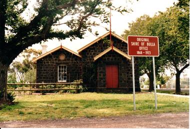
... The former bluestone Bulla Shire Hall building... melbourne The former bluestone Bulla Shire Hall building ...The former bluestone Bulla Shire Hall building was constructed in 1867 and remained the centre of local government until the early 20th century when the administration was moved to Sunbury. In the 1990's the Alister Clark Rose Garden was established in the surrounding grounds. The garden is open to the public all the year round. In 1999 the rose garden was officially opened.A coloured photograph of the front elevation of the original Shire of Bulla offices. It is a bluestone building, double fronted with a pitched roof on both wings and above the porch. The woodwork trims have been painted in cream and red. The double wooden front door is painted red. The sign outside the building indicates the former function of the building and its importance.ORIGINAL/SHIRE OF BULLA/OFFICE/1868-1923shire of bulla, council chambers, rose gardens, rose growing, bulla township, roses, clark, alistair, george evans collection -
 Hume City Civic Collection
Photograph
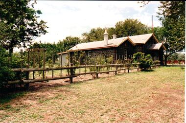
... The former bluestone Bulla Shire Hall building... melbourne The former bluestone Bulla Shire Hall building ...The former bluestone Bulla Shire Hall building was constructed in 1867 and remained the centre of local government until the early 20th century when the administration was moved to Sunbury. In the 1990's the Alistair Clark Rose Garden was established in the surrounding grounds. The garden is open to the public all the year round. In 1999 the rose garden was officially opened.A coloured photograph of the side garden and the bluestone building which was the shire offices of the former Shire of Bulla. A treated pine fence runs along the front of the property. The roses in the garden are supported with the stakes and there is a backdrop of trees behind the building.shire of bulla, council chambers, rose gardens, rose growing, roses, bulla township, clark, alistair, george evans collection -
 Eltham District Historical Society Inc
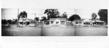
Negative - Photograph, Ian McDonald (Shire of Eltham), Main Road, between Arthur Street and Dudley Street, Eltham, 4 Jan. 1968
... L-R: Former Shire Hall and Shire Office, Photographer shop... melbourne L-R: Former Shire Hall and Shire Office, Photographer shop ...L-R: Former Shire Hall and Shire Office, Photographer shop, Barber shop, Fire Station, Hardware shop and Commercial Bank of Australia. Copied from an original document produced by Ian McDonald (Eltham Shire Council) 1970. During the period 1969-1971 photos were being collected for a proposed publication on the history of the Shire of Eltham as part of its centenary celebrations in 1971 (managed by the Shire of Eltham Historical Society and Alan Marshall). The publication was Pioneers & Painters (1971), edited by Alan Marshall. The document titled "Shows area sold to Woolworths" consisted of a panorama of three B&W photo prints creating a panorama of the frontage along Main Road (SEPP_0744) and a single B&W photo print of the Shire of Eltham offices and Hall on the corner of Arthur Street and Main Road (SEPP_0737) along with typed and hand written notes by Ian McDonald. The panorama (SEPP_0744) was captioned in typewritten text "Old Shire Office and Hall, etc - Frontage of 285 feet along Main Road" and in pencil the date "4-1-68" The single image of the shire offices (SEPP_0737) was captioned in typewritten text "Main Road and Arthur Street Corner" In addition, the following handwritten notes in pencil: " I took these photos from the new fire station - the building in the middle is the old fire station - Moved to Research for the Scouts 1970" and signed "IMcD"This photo forms part of a collection of photographs gathered by the Shire of Eltham for their centenary project book,"Pioneers and Painters: 100 years of the Shire of Eltham" by Alan Marshall (1971). The collection of over 500 images is held in partnership between Eltham District Historical Society and Yarra Plenty Regional Library (Eltham Library) and is now formally known as the 'The Shire of Eltham Pioneers Photograph Collection.' It is significant in being the first community sourced collection representing the places and people of the Shire's first one hundred years.Digital image 4 x 5 inch B&W Negsepp, shire of eltham pioneers photograph collection, eltham, main road, arthur street, dudley street -
 City of Greater Bendigo - Civic Collection
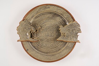
Decorative object - Ceramic platter, Bendigo Pottery, Strathfieldsaye Shire 1866 - 1991, 1991
... ) Strathfieldsaye Shire Hall is one of The City of Bendigo's earliest...) Strathfieldsaye Shire Hall is one of The City of Bendigo's earliest ...Graham Masters is a potter based at Sweenies Creek, just outside Bendigo, Victoria who specialises in a patented technique of low relief stoneware depicting Australian animals and landscapes. He obtained a Diploma of Art and Design in Ceramics from the Bendigo Institute of Technology in 1973, then operated a pottery for a year in Bendigo, before becoming an employee, then a partner at Maldon Pottery, Victoria with Neville Wilson and Thomas Metcalf. He left Maldon to set up his own pottery at Sweenies Creek in 1984. (1.) (Judith Pearce). Built in 1869, the (former) Strathfieldsaye Shire Hall is one of The City of Bendigo's earliest surviving public buildings. Designed by George Steane and built by George Pallett in 1869 the Strathfieldsaye Shire Hall has aesthetic significance as a purpose built Shire Hall designed in the Free Classical manner. It is also of importance as an early example of the novel system of cavity wall construction. The building is largely intact and unaltered. Other important elements include the arched portico of the main entrance with brick arched features on either side; the brick quoining and dressings to the round arch windows; the three gabled roof; and the matching chimneys that reinforce the symmetrical design. The Hall has social significance as a temporary schooling facility in the 1870s and as a flood refuge in 1889. The Strathfieldsaye Shire Hall is a brick building designed in the Free Classical manner. This style was favoured by the Public Works Department for a number of public buildings including Shire Halls and courthouses. The form includes a central taller volume flanked by matching smaller gables. In the case of the Shire Hall these would be occupied by the Shire Secretary and Shire Engineer whilst the larger volume was the council chamber. The portico at the front is designed with a flat arch in the centre and matching smaller arches each side. The face red brick is unadorned apart from a plain string course at the roof springing point, brick quoining and dressings to the round arch windows. There are matching chimneys that are located to reinforce the symmetrical design and the original roof is believed to have been slate but is now corrugated iron. Large wheel thrown ceramic platter with a shallow well, broad flaring ledge and raised on a high foot rim. Rim decorated with slab rolled gum trees protruding on centre left and right sides of plater. which reflect the low relief image of trees and the Strathfieldsaye Shire Hall on the surface of the plate. Glazed with golden brown and cream. Front centre top; 'Shire of Strathfieldsaye'. Front lower centre '1866 - 1991 - 125 Years'. Signed 'G Master / 1991' on rim centre right. Reverse; signed 'G Master' / 1991. Bendigo Pottery stamp.shire of strathfieldsaye, bendigo pottery -
 Eltham District Historical Society Inc
Document, Russell Yeoman, Tour of Historic Buildings and Locations, 1978
... shopping development was occupied by the former Eltham Shire... Shire Offices and Hall. The hall was paid for by public ...Self guided heritage tour information produced by the Shire of Eltham Historical Society for 1978 Eltham Community Festival of 36 locations each numbered on accompanying map. Locations and detail provided current to 1978: 1. ELTHAM SHOPPING CENTRE Whilst very little remains in the centre of historical importance, this area has interest as the "village" which developed over many years following the opening of the railway from Melbourne in 1902. Previously the shopping centre had been spread out over a long length of Main Road to the south. Shops have been continuously demolished or remodelled and the majority of buildings date from the 1950's or later. The recently erected Post Office replaced the "old" Post Office opened on the same site only in 1958. 2. WOOLWORTHS ELTHAM VILLAGE Part of the site of this modern shopping development was occupied by the former Eltham Shire Offices and Hall. The hall was paid for by public subscription whilst the Council raised a loan for the offices. The combined building was opened in 1941. It served as office and Council meeting place until 1965 and as the hall until its demolition in 1970. 3. ELTHAM WAR MEMORIAL The complex of buildings adjoining the present Shire Offices were financed by public subscription as a Memorial following World War II. Their construction and for many years their operation was organised by the now disbanded Eltham War Memorial Committee. The original buildings were the; Infant Welfare Centre, Children’s Library (now War Memorial Hall and Dental Clinic) and Kindergarten. In later years the Elderly Citizens Club was built at the rear. 4. ELTHAM SHIRE OFFICES These offices were opened in 1965 and extended in 1971 to provide additional office accommodation and the Eltham Library. They represent the last of a long line of offices and meeting places of the Eltham Shire Council and its predecessor the Eltham District Road Board. The building occupies the former site of Shillinglaw Cottage. The three tall cypress trees which stood in front of the Cottage have been retained as a feature of the office surrounds. 5. OUR LADY'S CHURCH AND SCHOOL The Catholic Church and School complex opposite the Shires Offices shows a number of stages in the development of Eltham township. The recently constructed church adjoins its predecessor (now the parish centre). Many years ago the Catholic Church was located opposite Wingrove Park and the present central site follows the northerly drift of the township. 6. SHILLINGLAW COTTAGE The Cottage was built in 1859 by George Stebbing, a local builder who was responsible for a number of other prominent buildings in the area. Its removal from the site of the Shire Offices and re-erection on the present site was financed by public subscription. It is built of handmade bricks laid in Flemish Bond with an unusual design featuring burnt "leader" bricks over the whole facade. The Cottage is occupied by Eltham Fleececrafts and will be open during the Festival and at other times during weekends. It is classified by the National Trust. 7. RAILWAY BRIDGE The timber trestle bridge over the Diamond Creek was built in 1901. Whilst all of its timbers have been replaced at various times over the years the only change to its character has been the addition of pylons and wiring for electric trains in 1923. It is one of very few similar bridges remaining in the metropolitan area. In 1976 a proposal to replace the bridge with an earth embankment and large culvert pipes was abandoned following community protests. The bridge, however, remains under threat because of the necessity for future deuplication of the railway line. 8. ELTHAM CENTPAL PARK The area between the railway and the creek has for many years been used as a park which included Eltham' s main football oval. The access road, Panther Place is named after Eltham's team playing in the Diamond Valley League. In recent years a large area extending to Bridge Street and locally known as the Town Park has been landscaped and added to the area. The excellent blending of the park with the natural landscape of the creek valley has earned a National Trust Landscape Classification. 9. OLD BAKERY On the southern corner of York Street and Main Road is an old house with a shop front which was for many years the local baker's shop. The brick bakery at the rear is of somewhat later vintage than the house. 10. BRIDGE STREET CUTTING Before reconstruction of Main Road this intersection had deep cutting embankments on all four corners, forming a distinctive feature of the entrance to Eltham. Roadworks and private development have levelled the land on the low side of the road. A memorial to the Eltham soldiers of World War I which was located at the north-western corner is now situated at the Eltham R.S.L. 11. HILLTOP MILK BAR For many years this was the site of the Eltham Post Office under the control of the Hunniford family and later their descendants the Burgoynes. It was transferred to this site in 1855, although at that time the building apparently fronted Bridge Str e et. The site contained Eltham's first telephone exchange. The post office was relocated in 1954 but the shop was operated until recently by the Burgoyne family who still own the surrounding land. 12. UNITING CHURCH and former C.B.A. BANK The former Methodist Church was built in 1880 by George Stebbing. The Sunday School extension was built in 1929 and there have been more recent extensions. The adjoining opportunity shop was built as a bank in 1874 and purchased by the Methodist Church in 1954. 13. R.S.L. HALL, TELEPHONE EXCHANGE These relatively recent buildings occupy the site of a row of shops forming part of the early ribbon of business development along Main Road. In front of the R.S.L. building is the World War I Memorial relocated from the corner of Bridge Street and Main Road. 14. ELTHAM COMMUNITY CENTRE Australia's first mudbrick "community building" was opened in April this year. Part of the site of the building was purchased in 1856 by Henry Dendy (of Brighton fame). At the rear of the land near the creek was a steam flour mill whilst Dendy's house was at the Main Road frontage of the land. His purchase totalled about 2 Ha (5 acres) and included land on the opposite side of Maria Street (Main Road). Dendy became a prominent member of the Eltham community and served one term as President of the Eltham District Road Board. In 1867 Dendy sold his land and business to William Ford of Malmsbury and shifted to Walhalla. The avenue of trees leading past the Community Centre to the creek may well have bordered the track to the mill. 15. ELTHAM HOTEL The original part of this hotel was built in 1927 following the burning of the former Watson's Eltham Hotel on the same site. The car park on the opposite side of Main Road was also the site of a hotel variously known over the years as; the Fountain of Friendship, the Fountain and the Evelyn Arms. As the Fountain of Friendship it was the first meeting place of the Eltham District Road Board in 1856. 16. ST. MARGARET'S CHURCH, PITT STREET In 1860 Henry Dendy was appointed Chairman of a committee to establish a church of England in Eltham. He donated part of his land in Pitt Street and in 1861 the church was opened. It was built by George Stebbing and remains in a well preserved state today. Th adjoining old vicarage is now named Dendy Hou se. A new mudbrick church hall is under construction on the site. The church and Dendy House are now listed on the Register of Historic Buildings. 17. NO. 86 PITT STREET Cottage built by George Stebbing and believed to be his home for some years in the 1850s. 18. LIVING AND LEARNING CENTRE The house was built in the 1850s with the kitchen at the front being added about 40 years later. By the creek below the house a number of early Eltham industries were located. These included a tannery and a brewery. 19. ELTHAM COURT HOUSE A Court of Petty Sessions was established in Eltham in 1858 and the present building dates from 1860. It is the oldest public building remaining in Eltham. In its early days the building was used as the meeting place and office of the Eltham District Road Board and as an overflow classroom for the local school. The Court House has been classified by the National Trust. The citation states that it is an example of the simple form of early brick Court House with gabled roof and porch. 20. LANDS DEPARTMENT OFFICE This building is the former police station and is probably of about the same age as the Court House. The lockup at the rear has been demolished but the old stables remain as garages. A licence was first granted for a police station at Eltham in 1856. 21. JARROLD COTTAGE The old Cottage opposite Dalton Street was formerly owned by the Jarrold family. Early records indicate that this was the building leased from the Jarrolds as a temporary police station prior to construction of the building on the corner of Brougham Street. The small building on the corner of the property was used as a boot repairer's shop. The elevated studio at the rear is a more recent construction by the present owners. 22. STATE SCHOOL RESIDENCE Erected in 1891 23. WINGROVE COTTAGE This building fills an important place in the history of Eltham and is now used as a medical clinic. It was built in 1858 for Charles S. Wingrove who was Secretary to the Eltham District Road Board and Shire Council from 1858 to 1904. During part of this period he was also Shire Engineer and was Secretary to the Heidelberg Road Board. The house was used as the office of the Board and Council for many years. Wingrove is buried in the cemetery at St. Helena. 24. WINGROVE PARK The parkland opposite Wingrove Cottage has been named after Charles Wingrove. The old Manna Gums are an outstanding feature of the park. 25. ELTHAM FRI.MARY SCHOOL NO. 209 The school first opened in the slab building in 1855 and operated from the present site since 1857. The oldest part of the present school is the stone building erected in 1876. The first school teacher, David Clark remained at the school until 1888. This school is the government township and has always been known as the Eltham School. An earlier school (no.371) known as Little Eltham School operated in Swan Street from 1853 to 1872. 26. "SHOESTRING" This house was built for school teacher David Clark. It has been extensively extended in recent years but the extensions do not detract from the character of the older part of the building. 27. ELTHAM CEMETERY The cemetery contains the graves of many of the district's pioneers . 28. MONTSALVAT This unique complex of buildings was commenced in 1935 by the late Justus Jorgensen and its development has extended over many years. Montsalvat has exerted a significant impact on Eltham The earth and stone construction of many of the buildings has influenced local architecture to a great extent and it has served as a "nerve centre" of the local artistic community. Montsalvat is open to the public for a small charge. 29. MAIN ROAD BRIDGE This location has been the main crossing of Diamond Creek since the earliest days of settlement. The present concrete bridge was erected in 1925 .and was preceded by a number of timber bridges. 30. ELTHAM LOWER PARK This park, being an unusually large flat area for Eltham, was originally the local racecourse. Horse races were held here from 1855 and the area was gazetted as a reserve for a racecourse and recreation reserve in 1857. The park is well known as a venue for school "bird days" and more recently as the site of the Diamond Valley Railway. This miniature railway features scale models of modern and old locomotives and rolling stock and has operated on this site since 1961 . Before that the railway operated at Chelsworth Park, Ivanhoe. 31. FALKINER HOUSE Frederick Falkiner was one of the earliest settlers in the Eltham township area and occupied a substantial leasehold prior to the first land sales. Early records show that Falkiner was the subject of a number of complaints from his neighbours but he has nevertheless been considered a prominent enough citizen to have a street named for him. This house was the home of Evelyn (Ely) Falkiner a member of Frederick's family. 32. WEST HOUSE Behind the large house on the hill is an early house built by the West family. This was relocated from a site near the front of the land by the present owner Mr. Fabbro. 33. FALKINER HOUSE This very old house is believed to have been the home of Frederick and may have been Eltham's first post office. Falkiner was the first post master for a short period. in 1854/55. 34. WITHERS HOUSE This house was the home of famous artist Walter Withers who shifted here from Heidelberg in 1903. 35. ELTHAM HIGH SCHOOL This school celebrated its jubilee this year, having commenced as the Eltham Higher Elementary School 50 years ago. 36. DIAMOND CREEK FOOTWAY If returning from the High School to the town centre the footpath by the bank of the Diamond Creek provides a pleasant route to finish your walk. The creek is a major tributary of the Yarra River. Together with its own major tributaries Arthurs Creek and Running Creek it commences on the southern slopes of the Dividing Range at Kinglake. It gives the name Diamond Valley to an area extending well beyond its actual drainage catchment.Recognition of the significance of various landmarks to the history of the Eltham community as of 1978‘shoestring’, 1978, bridge street cutting, burgoyne store, c.b.a. bank, diamond creek trail, eltham cemetery, eltham central park, eltham community centre, eltham community festival, eltham court house, eltham festival, eltham high school, eltham hotel, eltham lower park, eltham primary school, eltham railway trestle bridge, eltham shire offices, eltham shopping centre, eltham state school no. 209, eltham village, eltham war memorial, falkiner house, heritage trail, hilltop milk bar, jarrold cottage, lands department office, living, living and learning centre, main road bridge, montsalvat, old bakery, our eltham artistic recollections, our lady help of christian’s church, our lady help of christian’s primary school, pitt street, post office, r.s.l. hall, shillinglaw cottage, st margaret’s church, state school residence, stebbing cottage, telephone exchange, uniting church, west house, wingrove cottage, wingrove park, withers house, woolworths -
 Kiewa Valley Historical Society
Photograph - Mt Beauty Community Centre original colour plan and photos of upgrade in 2000, 1. Dated March 22nd, 1962 2. Photographs taken during renovations in 2000
The Community Centre was built in the early 1950’s as an all-purpose hall for the social and recreational use of the workers and families employed on the Victorian state government Kiewa Hydro-electric scheme. The hall was originally called Mt Beauty Recreation Centre and later changed to Mt Beauty Community Centre. It has been the heart of the community for over 65 years and had a heritage listing put on it around the year 2000. The Alpine Shire secured a heritage grant and the hall was restored to its former glory in 2000. In heritage circles it is claimed that the hall is the best example of a 1950’s construction town community hall, which is still functioning anywhere in AustraliaThe Community Centre was and is a very important part of life in the small remote community of Mount Beauty and a range of activities have taken place in the Community Centre over the past 65 years- Picture theatre; Dances and balls; A physical education and boxing club run by Alex McCollough for 30 years; School and social club concerts; Girls gymnastics; Drama group productions, revues and pantomimes; Callisthetics and ballet; Badminton; Wedding receptions and birthday parties; Music festival events; Staging area in times of natural disaster; The library for many years; Shire and community meetings; Secondary College gymnasium for many years and shelter for the Community Market in inclement weather 1 – 1972 specifications for colour scheme of original Mt Beauty Recreation centre, Typed on buff foolscap paper with small colour swatches and letter of explanation to Mr A.J. McCullough. 2 – Set of 10 colour photographs of the upgrade and extension to Mt Beauty Community Centre undertaken in 2000. Photos mounted 2 to a page on blue copy paper. 3. Second copy of No.1 above. Also - typed A4 sheet re history of "The Mount Beauty Community Centre"1 – Header on pages-Mate’s Colour Bar Personal Colour Scheme for Recreation Centre Mt Beauty Vic. 21/3/62. Accompanying letter to A.J McCullough signed by Colour Consultant Ena Chatuein 2. First page of photos, written in black felt marker – Mt Beauty Community Centre 30/11/00 mt beauty, community centre