Showing 12057 items
matching geo-map
-
 Narre Warren and District Family History Group
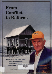
Book, Doug Thompson, From conflict to reform : from 5-1-1798 Geo. Bass into Mornington Peninsula Shire constituted 15-12-1994, 1997
Part autobiography of Doug Thomspon, part history of Hastings Shire and the Hastings - Western Port Historical Society.non-fictionPart autobiography of Doug Thomspon, part history of Hastings Shire and the Hastings - Western Port Historical Society. shire of hastings, western port settlement, douglas m thompson -
 Melbourne Tram Museum
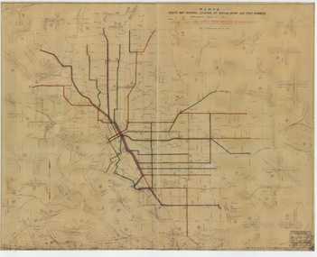
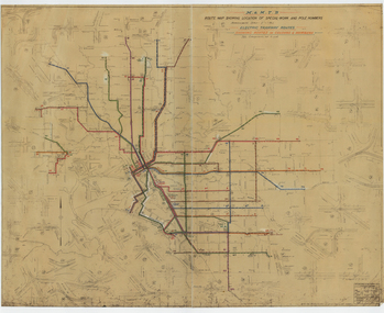
Drawing, Melbourne & Metropolitan Tramways Board (MMTB), "Route Map showing location of special work and pole numbers" "All night tram routes in colours", late 1941
Map of the system shown at two inches = 1 mile. Drawing No. P5799. Shows crossovers, track layouts at junctions, signal cabins roads, railways, and stations. Originally signed by Perway Engineer - 20/12/1940, though originally drawn in 1922. Has been marked up in colour pencil to show the all-night routes and the individual services. The plan shows the lines to Maribyrnong Munitions works along Cordite Ave and Wests Road and the track from Moonee Ponds to Union Road, opened in July 1941, but not the extension to Essendon Airport built in 1942.Demonstrates a detail drawing of Melbourne tramways, junctions and pole numbers.Drawings - dyeline cloth-backed print - titled - "Route Map showing the location of special work and pole numbers" and subtitled - "All night tram routes in colours". trams, tramways, mmtb, trackwork, tramways, junction, map, world war 2, night trams -
 Bacchus Marsh & District Historical Society
Map, Mooradoranook Parish Map, County of Grant
A single page paper map showing the map for the Parish of Mooradanook in the County of Grant. Cadastral map showing land ownership. The map is pasted into a bound volume containing 76 maps or plans in total. High resolution digital image stored on BMDHS computer network. Photo lithographed at the Department of Lands and Survey Melbourne by T. F. McGauran, 27.11.06mooradoranook parish maps, mooradoranook parish plan, bacchus marsh region parish plans -
 Bacchus Marsh & District Historical Society
Map, Mouyong Parish Map, County of Grant
A single page paper map showing the map for the Parish of Mouyong in the County of Grant. Cadastral map showing land ownership. The map is pasted into a bound volume containing 76 maps or plans in total. High resolution digital image stored on BMDHS computer network. Photo lithographed at the Department of Lands and Survey Melbourne by T. F. McGauran, 9. 4. 07mouyong parish plan, mouyong parish maps, bacchus marsh region parish plans -
 Warrnambool RSL Sub Branch
Map - 1947 Minesweeping map, North Queensland minesweeping map, unknown
1947 an after-effect od WW2Laminated A3 Map plus A4 map in pocket (copies of original)shows location of minefields to be cleared in 1947 and names of minesweeping ships!947 ran history -
 National Vietnam Veterans Museum (NVVM)
Map, Map of Area Surround Luscombe Airfield
Laminated map of military installations surrounding Luscombe Airfield. No identification of the map.luscombe field -
 Bacchus Marsh & District Historical Society
Map, Myrniong Parish Map 1904
A single page paper map showing the map for the Parish of Myrniong in the County of Bourke. A cadastral map showing parish boundaries and land ownership. The map is pasted into a bound volume containing 76 maps or plans in total. High resolution digital image stored on BMDHS computer network. myrniong parish plan, myrniong parish maps, bacchus marsh region parish plans -
 Bacchus Marsh & District Historical Society
Map, Parwan Parish Map, County of Grant, 1909
A single page paper map showing the map for the Parish of Parwan in the County of Grant. A cadastral map showing parish boundaries and land ownership. The map is pasted into a bound volume containing 76 maps or plans in total. High resolution digital image stored on BMDHS computer network. Photo-lithographed at the Department of Lands and Survey, Melbourne by T.F. McGauran, 7.7.09. bacchus marsh region parish plans, parwan parish maps, parwan parish plan -
 Bacchus Marsh & District Historical Society
Map, Blackwood Parish Map, County of Bourke, 1892
A single page paper map showing the map for the Parish of Blackwood in the County of Bourke. A cadastral map showing parish boundaries and land ownership. The map is pasted into a bound volume containing 76 maps or plans in total. High resolution digital image stored on BMDHS computer network. Photo-lithographed at the Department of Lands and Survey, Melbourne by T.F. McGauran 14.7.92bacchus marsh region parish plans, blackwood parish plan, blackwood parish maps -
 Bacchus Marsh & District Historical Society
Map, Blackwood Parish Map, County of Bourke, 1905
A single page paper map showing the map for the Parish of Blackwood in the County of Bourke. A cadastral map showing parish boundaries and land ownership. The map is pasted into a bound volume containing 76 maps or plans in total. High resolution digital image stored on BMDHS computer network. Photo-lithographed at the Department of Lands and Survey, Melbourne by T.F. McGauran 21.7.05bacchus marsh region parish plans, blackwood parish plan, blackwood parish maps -
 Bacchus Marsh & District Historical Society
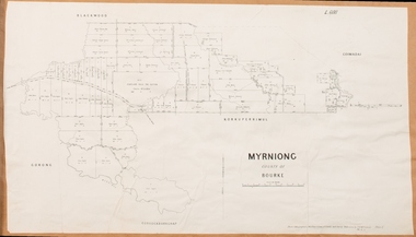
Map, Myrniong Parish Map, County of Bourke, 1882
A single page paper map showing the map for the Parish of Myrniong in the County of Bourke. A cadastral map showing parish boundaries and land ownership. The map is pasted into a bound volume containing 76 maps or plans in total. High resolution digital image stored on BMDHS computer network. Photo-lithographed at the Department of Lands and Survey, Melbourne by J. Noone, 17.7.82myrniong parish plan, myrniong parish maps, bacchus marsh region parish plans -
 Bacchus Marsh & District Historical Society
Map, Trentham Parish Map 1905 Copy 1
A single page paper map showing the map for the Parish of Trentham in the Counties of Dalhousie and Bourke. A cadastral map showing parish boundaries and land ownership. The map is pasted into a bound volume containing 76 maps or plans in total. High resolution digital image stored on BMDHS computer network. Photo-lithographed at the Department of Lands and Survey, Melbourne by T.F. McGauran 22.3.05 trentham parish maps, trentham parish plan, bacchus marsh region parish plans -
 Bendigo Military Museum
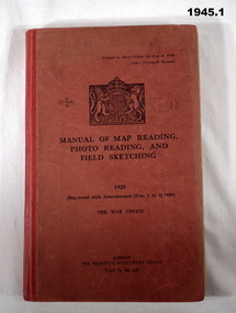
Manual - TRAINING SERIES, 2), .3), & .4) Her Majesty's Stationery Office, Manual of Map Reading, Photo Reading, and Field Sketching, 1) 1929, Reprint 1939; .2) 1955; .3) 1957; .4) 1958
Training Manuals - War Office London 1920 - 1939. .1) Red coloured cardboard with red coloured buckram, spine, black print on front & Coat of Arms. 166 pages, cut, plain, off white paper with black & white & coloured maps & diagrams. .2), .3) & .4) Red coloured cardboard with red coloured buckram, spine, black print on front. Cut, plain, off white paper with black & white & coloured maps & diagrams. .2) 132 pages. .3) 80 pages. .4) 69 pages. .1) “1929 Reprinted with amendments No's 1 to 4 1939” .2) “1955 Part 1 Map Reading” .3) “1957 Part III Field Sketching” Front fly leaf in red ballpoint pen: “S Sgt Moore / LAD” .4) “1958 Part II Air Photo Reading”books-military history, technical, documents - maps -
 Melbourne Athenaeum Archives
Booklet, Walking the City of Literature / A Literary Map of Melbourne, 2017
Athenaeum library is listed Booklet / MapMarkings of Melbourne's Bookstores and Libraries. athenaeum library, melbourne -
 Ringwood RSL Sub-Branch
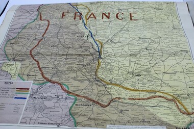
Souvenir - Map of France, Battlefront lines marked on map.1918
Map of France -
 Melbourne Tram Museum
Drawing, Melbourne & Metropolitan Tramways Board (MMTB), "Route Map showing location of special work and pole numbers" "Electric Tramway Routes - showing routes in colours and numbers", late 1941
Map of the system shown at two inches = 1 mile. Drawing No. P5799. Shows crossovers, track layouts at junctions, signal cabins roads, railways and stations. Originally signed by Perway Engineer - 20/12/1940, though originally drawn in 1922. Has been marked up in coloured pencil to show the routes and route numbers. The plan shows the lines to Maribyrnong Munitions works along Cordite Ave and Wests Road and the track from Moonee Ponds to Union Road, which opened in July 1941, but not the extension to Essendon Airport built-in 1942. See Reg Item 1561 for a 1963 version and 1683 for a 1987 versionDemonstrates the use of a MMTB drawing to show tram routes and their route numbers at the time.Drawings - dyeline cloth backed print - titled - "Route Map showing location of special work and pole numbers" and subtitled - "Electric Tramway Routes - showing routes in colours and numbers". trams, tramways, mmtb, trackwork, tramways, junction, map, world war 2 -
Federation University Historical Collection
Map, Robinson's Ballarat Street Map, c1972, 1970s
A coloured fold-out street map of Ballarat. It also includes a district road map.ballarat, map, ballarat streets -
Federation University Historical Collection
Map, Map of Vitilevu showing vehicular roads, native tracks, villages, provinces, 1935
Printed map on paper backed onto linen with small inset maps of Nandi and Singatoka map, vitilevu, singatoka, nandi -
 Bendigo Military Museum
Photograph - Royal Australian Survey Corps - Map Production Processes, c1990
This is a collection of 20 photographs of Royal Australian Survey Corps phases of map production at the School of Military Survey, Bonegilla, the Army Survey Regiment, Bendigo, and the Army Map Depot, Bandiana circa 1990. Colour photos are on 35mm slide film and were scanned at 96 dpi. They are part of the Army Survey Regiment’s Collection. Photo .1P was probably taken on a survey station overlooking Lake Hume near Albury-Wodonga. The field party occupying the survey station was likely from a Map Control Survey course conducted by the School of Military Survey, Bonegilla. This survey station was part of a geodetic network used in field survey training and RASvy’s Lake Hume Test Range. Photos .3P to .16P were taken at the Army Survey Regiment, Bendigo and photos .17P & .18P were taken at the Army Map Depot, Bandiana. Photo .19P depicts a map of RASvy’s ARA units before the disbandment of 5th Field Survey Squadron, Perth and 2nd Field Survey Squadron, Sydney in 1990. This is a collection of 20 photographs of map production processes taken at the School of Military Survey, Bonegilla, the Army Survey Regiment, Bendigo, and the Army Map Depot, Bandiana circa 1990. Colour photos are on 35mm slide film and were scanned at 96 dpi. They are part of the Army Survey Regiment’s Collection. Photo .2P is printed on photographic and scanned at 300 dpi. .1) – Photo, colour, c1980s. Geodetic Surveying: AN/PRR-14 Geoceiver antenna on hill surrounding Lake Hume. Series 3 Land Rover, field party tent and survey station beacon in background. .2) – Photo, black & white, c1980s. Geodetic Surveying: AN/PRR-14 Geoceiver antennas set up at the School of Military Survey, Bonegilla, Victoria. .3) – Photo, colour, c1990. Aerotriangulation: Wild PUG4 point transfer device, SSGT Bruce Hammond. .4) – Photo, colour, c1990. Aerotriangulation: Zeiss (Jena) Stecometer, SSGT Bruce Hammond. .5) – Photo, colour, c1990. Aerotriangulation: computer tape maintenance, SSGT Noel McNamara. .6) – Photo, colour, c1990. AUTOMAP 2: computer tape maintenance, SPR Nadine (Paul) Read. .7) - Photo, colour, c1990s. AUTOMAP 2: Optronics 4040 scanning/film output in Lithographic Squadron, SGT Sherri (Dally) Burke. .8) - Photo, colour, c1990s. AUTOMAP 2: Benson verification plotter output, SPR Nadine (Paul) Read. .9) – Photo, colour, c1990. Aerotriangulation: data management, SGT Neil ‘Ned’ Kelly. .10) & .11) - Photo, colour, c1990s. AUTOMAP 2: Wild B8 Aviograph stereoplotter Feature Extraction, unidentified technician. .12) - Photo, colour, c1990s. AUTOMAP 2: Graphic Edit Workstation, SPR Nadine (Paul) Read. .13) - Photo, colour, c1990s. AUTOMAP 2: Graphic Edit Workstation, SPR Dawn Hoadley. .14) & .15) - Photo, colour, c1990s. AUTOMAP 2: Graphic Edit Workstation, unidentified technician. .16) – Photo, colour, c1990s. Heidelberg Speedmaster 102 computer-controlled five colour lithographic offset printing press. .17) & .18) – Photo, colour, c1990s. Army Map Depot, unidentified storeman, Bandiana. .19) – Photo, colour, c1990. RASvy ARA Unit Locations before disbandment of field units in Perth and Sydney. .20) – Photo, colour, c1990. Set of overlapping aerial photography..1P, .3P to .20P - Some equipment is identified on the frame of the 35mm slides.royal australian survey corps, rasvy, army survey regiment, army svy regt, fortuna, asr, school of military survey, army map depot -
 Kew Historical Society Inc
Plan - Subdivision Plan, Jas R Mathers Son & McMillan, Eastlawn Estate : East Kew Auction Sale, 1914
The Kew Historical Society's map collection includes a substantial number of real estate subdivision plans, mainly of Kew but also of surrounding suburbs in Melbourne. Most of the subdivision plans date from the 1920s and 1930s when the districts old homes and local farmland were being split up to accommodate residential growth in the postwar period. These early plans were assembled by a local firm, Jas R Mather & McMillan, which had an office in Cotham Road. Many of the plans, and sometimes photos, were annotated by the agents.Subdivision plans are historically important documents used as evidence for the growth of suburbs in Australia. They frequently provide information about when the land was sold as well as evidence relating to surveyors and real estate and financial agents. The numerous subdivision plans in the Kew Historical Society's collection represent working documents, ranging from the initial sketches made in planning a subdivision to printed plans on which auctioneers or agents listed the prices for which individual lots were sold. In a number of cases, the reverse of a subdivision plan in the collection includes a photograph of a house that was also for sale by the agent. These photographs provide significant heritage information relating house design and decoration, fencing and household gardens.The photograph may also be aesthetically significant depending on the importance of the photographic atelier.The ‘Eastlawn Estate’ was surveyed and ready for auction in March 1914, three months before the outbreak of World War I. Sixty-six allotments, created on the ‘order of Mr & Miss Preston’ surrounded the mansion of Woodlands in Harp Road. Woodlands formed part of the Estate, being advertised as lot 1. The allotments faced High, Station and Wright Streets, Harp and Normanby Roads, and Woodlands Avenue. Pru Sanderson in the Kew Conservation Study (Vol.2, 1988) wrote that the Eastlawn Estate ‘covered the western half of the failed Harp of Erin Estate’. Contemporary advertisements promoted the Eastlawn Estate as: ‘There will be no more convenient district nor pleasant Suburb than East Kew for the busy business man. When the Electric Tram is laid, he will be able to journey quickly and pleasantly direct from Collins Street to his home in the Eastlawn Estate in about 20 minutes’. The actual plans of subdivision were included in advertisements in The Argus and in the local newspapers."C" top left. Various annotations.subdivision plans - kew, station street, normanby road, high street, woodlands avenue, harp road, woodlands - kew -
 Kew Historical Society Inc
Map, Robert Russell, Map Shewing the Site of Melbourne and the Position of the Huts & Buildings Previous to the Foundation of the Township by Sir Richard Bourke in 1837
Map shows the first layout of Melbourne by Government surveyor Robert Russell, who accompanied Governor Richard Bourke in 1837. The surveyed blocks extend from present-day Flinders Street to Lonsdale Street, and Spring Street to Spencer Street, with extensive vacant land west to a salt lake (afterwards Batman's Swamp, later drained), north beyond Flagstaff Hill and south towards South Melbourne. Vegetation coverage is indicated, and tracks and existing buildings and cultivated land are shown.Printed map was created by Day & Haghe, Lithographers to the Queen, sometime after 1838, when the company received its Royal appointment. Copies of the 1837 map exist in several major map collections in Australia; most are uncoloured. This particular map is the earliest in the Kew Historical Society's map collection. It is a nationally significant artefact. Black and white lithographed map hand-coloured in blue and yellow gouache of the town of Melbourne in 1837. In contrast to the original lithograph, the river and the township blocks are coloured blue and yellow. A similar, partly coloured copy is in the collection of the University of Melbourne.maps - melbourne - 1830s, governor sir richard bourke, robert russell - surveyor, cartography -
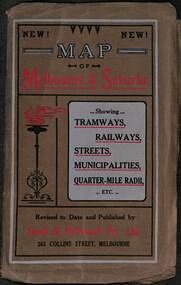 Melbourne Tram Museum
Map, Sands McDougall, Map of Melbourne and Suburbs showing Tramways, Railways, Streets, postal districts, Quarter-Mile Radii etc", c1919
Shows railways, cable and electric tram lines c1919. One of a number of maps produced by Sands McDougall of Collins St. Includes the MTOCo zoo horse tram lines, the PMTT, HTT and MBCTT lines, but not the FNPTT or the FTT lines. See items 2885 and 6573 for other editions. Yields information about Melbourne c1919 and its public transport lines. Produced by Sands and McDougall Pty Ltd of Collins St Melbourne. folded sheet of paper 6 sections wide x 6 sections or folds deep contained within a brown paper cover titled "Map of Melbourne and Suburbs showing Tramways, Railways, Streets, postal districts, Quarter-Mile Radii etc", showing both cable and electric tramways. maps, melbourne, cable trams, tramways, railways, horse trams, nmetl, vr trams, sands mcdougall, mbctt, pmtt, htt, zoo horse tramway -
4th/19th Prince of Wales's Light Horse Regiment Unit History Room
Booklet, Manual of Map Reading, Air Photo Reading & Field Sketching Part 1 Map Reading 1955, 1955
Hard covered booklet for use of officer, NCOs and candidates for commission in the British Army and RAF explaining how to use a map and how to extract information from it. 4 copiesWO Code No 8868map reading -
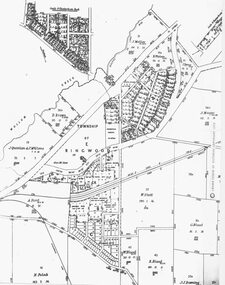 Ringwood and District Historical Society
Photograph, Parish Map - Township of Ringwood - 1890
Written on backing sheet, 'SLV Parish Map Collection. Vol.67, Fol. 43, 1890'. Catalogue card reads, 'SLV Parish Map Collection 1890. (Township of Ringwood). -
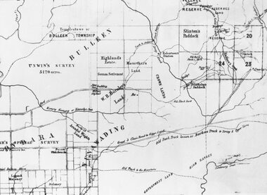 Ringwood and District Historical Society
Photograph, Circa 1855 Parish Map including Bulleen, Nunawading, and eventual site of Ringwood below blocks 23 & 24
Catalogue card reads, "C1858 Parish Map - Nunawading, Ringwood & Scoresby". -
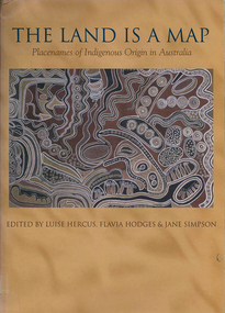 Victorian Aboriginal Corporation for Languages
Book, Luise Hercus, The land is a map : placenames of Indigenous origin in Australia, 2002
Place names often evoke important information about features of the environment and their place in Indigenous knowledge. On the other hand, place names given by European settlers are largely arbitrary.Maps, b&w photographs, b&w illustrations, word listsplace names, wik, cape york peninsula, ngalakgan, alawa, marra, yukgul, kaurna, yuwaalaraay, yuwaaliyaay, gamilaraay, ngiyampaa -
 Bendigo Military Museum
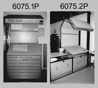
Photograph - Equipment used in Map Production at the Army Survey Regiment, 1991
These nine photographs of technical equipment were provided to the Directorate of Survey as input to the 1990-1991 Annual Report. The equipment in Photos .1P and .2P were used to evaluate/validate colour values on printed maps. The equipment in Photo .3P is a daylight film processor. The Optronix 5040 Laser Scanner/Plotter was shown in Photos .4P to .6P. The Print Room’s Map Handling Station in photo .7P provided ergonomic benefits to the Printer Technician and improved despatching productivity. The Optical Disk Archive and Retrieval System (ODARS) equipment in .8P was optical "platter" disk technology for the secure and long term archive storage of large amounts of digital map data. Map data was transferred from large reels of magnetic tape. As most map type (letters and names) generation was done in Automap 2, The ITEK Typesetter shown in photo .9P was close to obsolete in 1991. At this time it was used to generate map type for other RASvy units, contractors and sections still performing manual map production at Army Svy Regt.This is a set of photographs of Army Survey Regiment technical equipment taken in 1991. The photographs were printed on photographic paper and are part of the Army Survey Regiment’s Collection. The photographs were scanned at 300 dpi. .1) - Photo, black & white, 1991, Colour Evaluation Workstation No 1, Lithographic Squadron .2) - Photo, black & white, 1991, Colour Evaluation Workstation No 2, Lithographic Squadron .3) - Photo, black & white, 1991, Daylight film processor, Lithographic Squadron, Daylight Working Contacting Frames in background. .4) - Photo, black & white, 1991, Optronix 5040 Laser Scanner/Plotter, Lithographic Squadron .5) - Photo, black & white, 1991, Optronix 5040 Laser Scanner/Plotter, Lithographic Squadron .6) - Photo, black & white, 1991, Optronix 5040 Laser Scanner/Plotter, Lithographic Squadron .7) - Photo, black & white, 1991, Map Handling Station, Lithographic Squadron .8) - Photo, black & white, 1991, Optical Disk Archive and Retrieval System (ODARS), Cartographic Squadron .10) - Photo, black & white, 1991, Optronix 5040 Laser Scanner/Plotter, Lithographic Squadron .9) - Photo, black & white, 1991, ITEK Typesetter, Cartographic Squadron.1P, .2P, .4P to .10P – equipment description annotated on back .3P - no annotation.royal australian survey corps, rasvy, army survey regiment, army svy regt, fortuna, asr, litho, automap -
 Federation University Historical Collection
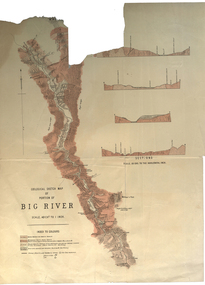
Plan, Geological Sketch Map of Portion of Big River
Printed map on paperscale, index to colours, sectionsgeological sketch map, plan, big river, mount wills, geology -
Federation University Historical Collection
Map, Topographical Map Creswick A & B
Printed map on papercreswick, clunes, lexton, waubra, smeaton -
 Federation University Historical Collection
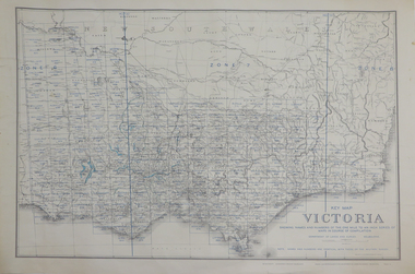
Map, Key Map of Victoria, 1917, 13/12/1917
Printed colour mapvictoria