Showing 2951 items matching "highways"
-
 Whitehorse Historical Society Inc.
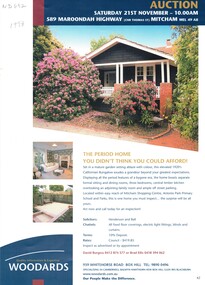
Pamphlet, The Period home you didn't think you could afford, 1/11/1998 12:00:00 AM
Advertising brochure for a period home at 589 Maroondah Highway,Advertising brochure for a period home at 589 Maroondah Highway, Mitcham for auction on 21 November 1998Advertising brochure for a period home at 589 Maroondah Highway,auctions, maroondah highway, mitcham, no 589, whitehorse road -
 Whitehorse Historical Society Inc.
Document, Full steam for Eastlink
Work continuing on Mullum Mullum Valley tunnels and Ringwood bypass and Maroondah Highway bridge (photos).Work continuing on Mullum Mullum Valley tunnels and Ringwood bypass and Maroondah Highway bridge (photos).Work continuing on Mullum Mullum Valley tunnels and Ringwood bypass and Maroondah Highway bridge (photos).eastlink, ringwood bypass, maroondah highway, mullum mullum valley, deep creek road, mitcham, eastern freeway extension, tunnels -
 Whitehorse Historical Society Inc.
Photograph, Tally Ho Land
Coloured photo of Tally Ho Land, Corner Springvale Road and Burwood Highway before development.tally ho -
 Whitehorse Historical Society Inc.
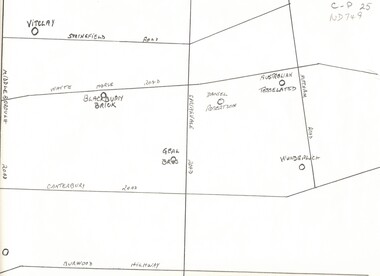
Map, Potteries, n.d
Sketch map of location of potteries in the area bounded by Middleborough, Springfield, Mitcham Roads and Burwood Highway.Sketch map of location of potteries in the area bounded by Middleborough, Springfield, Mitcham Roads and Burwood Highway.Sketch map of location of potteries in the area bounded by Middleborough, Springfield, Mitcham Roads and Burwood Highway.potteries, vitclay pipes pty ltd, blackburn brick and tile co., geal bros., wunderlich limited, australian tesselated tile co. pty ltd., daniel robertson australia pty ltd -
 City of Kingston
Photograph - Black and white, c. 1950
This image shows a sealed road running along South Road, although with a wide gravel shoulder. The railway crossing gates were hand operated. This image is one of many in the collections that focuses on the railway. The development of the railway was crucial to the ongoing development of the area. Community life often sprang up along and beside the railway.Black and white photograph of the railway crossing at South Road, Moorabbin, viewed from Nepean Highway. Handwritten in blue ink on reverse: 217 Handwritten in red ink on reverse: 80%moorabbin, railway, railway crossing -
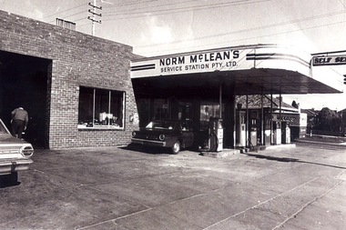 Whitehorse Historical Society Inc.
Photograph, McLean's Garage, East Burwood 1960s
Renovated by Norm McLeanBlack and white Photo of McLean's Garage on corner Middleborough Road & Burwood Highway as renovated in 1960smclean's garage, east burwood -
Lakes Entrance Historical Society
Map - Map Lake King Princes Highway
Map showing Lake King Princes Highway showing different points in Lake King for fishingfishing, guide -
 Lakes Entrance Historical Society
Photograph - Bonang Highway, East Gippsland Victoria, Marie Fish, Martins Creek Bridge, 1990 c
Colour photograph of wooden bridge over Martins Creek on Bonang Highway East Gippsland Victoriabridges, riv, roads and streets, engineering -
Lakes Entrance Historical Society
Domestic object - Souvenir Ashtrays
Collection of three glass ashtrays with photographs of Esplanade, Princes Highway, Jemmys Point Lakes Entrancetourism, mementos -
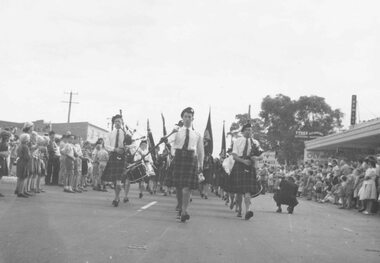
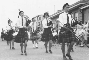 Ringwood and District Historical Society
Photograph, City of Ringwood celebrations, 1960
Black and white photographImage shows bands in procession along Maroondah Highway. -
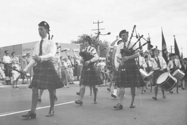 Ringwood and District Historical Society
Photograph, City of Ringwood celebrations, 1960
Black and white photographImage shows bands in procession along Maroondah Highway. -
 Ringwood and District Historical Society
Photograph, City of Ringwood celebrations, 1960
Black and white photographImage shows bands in procession along Maroondah Highway. -
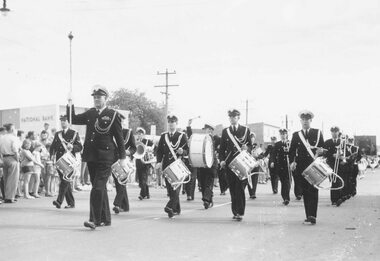 Ringwood and District Historical Society
Photograph, City of Ringwood celebrations, 1960
Black and white photographImage shows band in procession along Maroondah Highway -
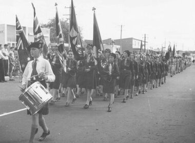 Ringwood and District Historical Society
Photograph, City of Ringwood celebrations, 1960
Black and white photographImage shows marchers in procession along Maroondah Highway. -
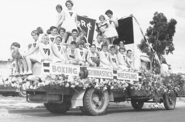 Ringwood and District Historical Society
Photograph, City of Ringwood celebrations, 1960
Black and white photographImage shows floats in procession along Maroondah Highway. -
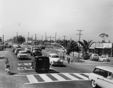 City of Kingston
Photograph - Black and white, c. 1957
Copy black and white photograph of railway level crossing on Nepean Highway Moorabbin before excavations for the below ground rail crossing. The level crossing gates are closed and five cars are waiting, while other cars can be seen coming in the opposite direction. A woman with a child in a pram is walking along the road, and a number of men, probably construction workers, are standing behind a barricade on the right hand side of the road. Gilbey's Gin distillery is visible in the background. TCopy black and white photograph of railway level crossing on Nepean Highway Moorabbin before excavations for the below ground rail crossing. The level crossing gates are closed and five cars are waiting, while other cars can be seen coming in the opposite direction. A woman with a child in a pram is walking along the road, and a number of men, probably construction workers, are standing behind a barricade on the right hand side of the road. Gilbey's Gin distillery is visible in the background. Handwritten in blue ink on reverse: 57-465C Handwritten in red ink on reverse: 71% A red circle has been drawn around all handwritten text.moorabbin, railway station, railway crossing, suburbs, cars, local production -
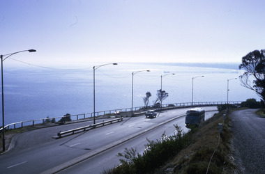 Robin Boyd Foundation
Slide, Robin Boyd, 1967
Colour slide in a mount. View of Port Phillip Bay, Nepean Highway, Olivers Hill, Frankston, VictoriaMade in Australia / 20 / JUN 67M1 / Encircled 44 (Handwritten)slide, robin boyd -
Clunes Museum
Map
A MAP OF THE BOROUGH OF CLUNES. SCALE 20 CHAINS TO 1 INCH. MAIN HIGHWAYS NAMED. NO STREET NAMESdocument maps, borough of clunes map -
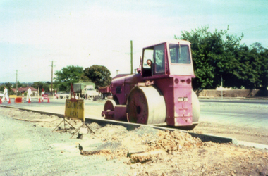 Whitehorse Historical Society Inc.
Photograph, Canterbury Road Vermont
Coloured print of a 110 slide of the making of the dual highway of Canterbury Road Vermont, near Mitcham Road.canterbury road vermont, mitcham road, vermont, roads and streets -
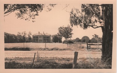 Rutherglen Historical Society
Image, c1980
Photograph of Fairfield House and Cellars, possibly during its restoration. House, Cellars and grounds were purchased and restored by Mrs Melba Slamen, the Great-Granddaughter of the original builder, George Francis Morris.Black and white photograph of Fairfield House and Cellars, taken from the other side of the Murray Valley HighwayWritten on back of photo: "S/S A [letter in circle] Fairfield"fairfield house, melba slaman, george francis morris, morris family -
![Photographs [Series], Noel Kelly, Chandler Highway Bridge Construction, 11/07/2018](/media/collectors/550653872162f11fb04854aa/items/5c2f52bd21ea670d20783d9e/item-media/5c2f53b221ea670d2079233e/item-fit-380x285.jpg) Kew Historical Society Inc
Kew Historical Society IncPhotographs [Series], Noel Kelly, Chandler Highway Bridge Construction, 11/07/2018
A selection of photographs taken in July/August 2018 recording work on the old and new Chandler Highway Bridges.chandler highway bridge, noel kelly, railway viaduct - river yarra -
 Kew Historical Society Inc
Photograph, Chandler Highway Bridge, 1930s
The railway viaduct linking the Outer Circle railway from Kew to Fairfield was constructed in the 1890s. In the 1930s it was converted into a motorway bridge.Photocopy of a photograph of the bridge linking Kew and Fairfield. Dated to the 1930s following the construction off the Chanler Highway.outer circle railway, viaduct (kew fairfield), john monash, chandler highway bridge -
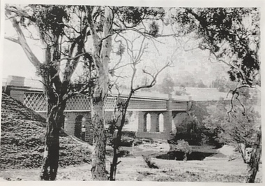
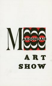 Ringwood and District Historical Society
Pamphlet, 1970 Maroondah Art Show Catalogue
Ringwood Jaycees presents The Thirds Annual 1970 Maroondah Art Show at Eastland, Maroondah Highway, RingwoodTuesday 31st March to Saturday 11th April. Raising money for the Maroondah Hospital Appeal. -
 Whitehorse Historical Society Inc.
Photograph - Colour Photograph, Tally Ho Business Park 2003
Tally Ho Business Park was developed by Land Lease, commencing in 1988, and then CGA Bryson from the late 1990's. It was completed in 2002. The land on which it stands was previously the site of the Tally Ho Boys Home. This home was run, from 1903-1986 by the Wesley Central Mission, which caters for boys from the slums. It closed in 1986.Coloured photograph of Tally Ho Business Park in the early stages, looking north towards Burwood Highway.tally ho, business park, 2003 -
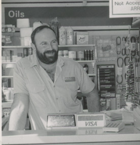 Lakes Entrance Historical Society
Photograph - Esso Service Station, Lakes Post Newspaper, 1991
Black and white photograph of David Fileder of Esso Service Station Princes Highway Lakes Entrance Victoriabusinesses, people -
 Lakes Entrance Historical Society
Postcard - Bullock Island Lakes Entrance, H D Bulmer, 1950 c
Bullock Island and first traffic bridge. Bullock Island has no development. North Arm bridge and Princes Highway in foreground, New Works area across Cunninghame Arm in distance Lakes Entrance Victoria. Also a cut down colour photograph of second humpy bridge to Bullock Island donated by M Fish number 04208.1 size 3 x 13 cm|Also two black and white photographs numbers 04208.2 and 04208.3 in SparesColour tinted postcard of Bullock Island and first traffic bridge. Bullock Island has no development. North Arm bridge and Princes Highway in foreground, New Works area across Cunninghame Arm in distance Lakes Entrance Victoria. Also a cut down colour photograph of second humpy bridge to Bullock Island donated by M Fish number 04208.1 size 3 x 13 cm|Also two black and white photographs numbers 04208.2 and 04208.3 in Spares Bullock Island and Bridge Lakes Entrance waterways, gippsland lakes, islands, vegetation -
 Melbourne Tram Museum
Letter, Australian Electric Traction Association (AETA), "Proposal to build a tramline down Nepean Highway to Southland", May. 1977
Letter with supplementary document - "Proposal to build a tramline down Nepean Highway to Southland", advocating residents support a study into a possible tram line to Southland, May 1977. The Nepean Highway was being widened at the time. Produced by the AETA. Printed by duplicating process on white foolscap paper.trams, tramways, public transport, mmtb, proposals, moorabbin -
 Ringwood and District Historical Society
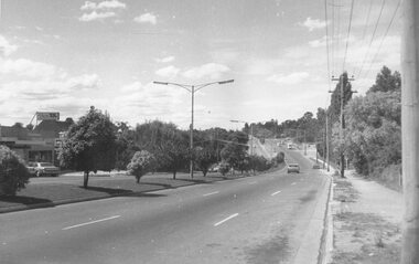
Photograph, Maroondah Highway East, Ringwood in 1973. Eastward view along Maroondah Highway towards Mount Dandenong Road
Black and white photographTyped on back of photograph: "Maroondah Highway by the lake. Looking east towards Mt. Dandenong Rd. - 1973". Ringwood Lake is on the right hand side of the highway. -
 Ringwood and District Historical Society
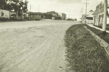
Photograph, Cnr Maroondah Hwy and Ringwood Street, Ringwood. (undated)
Written on back of photograph, "Left hand side of picture: Post Office on corner of Maroondah Highway and Ringwood Street. Right hand side Ibbotson & Sons Highway and corner store, corner Maroondah Highway and Wantirna Road. In distance old cool stores." -
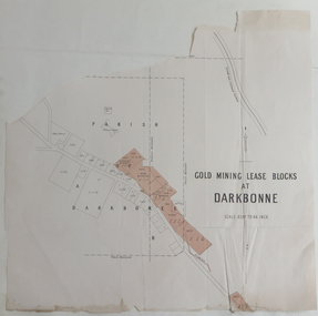 Federation University Historical Collection
Plan, Goldmining Lease Blocks at Darkbonne, c1887
This map was originally inserteed into the Reports of Mining Registrars for the Quarter ender 30th June 1887.Paper plan showing Goldmining Lease Blocks at Darkbonne, north west of and near St Arnaud, on the Sunraysia Highway. darkbonne, st arnaud, new bendigo mine, alpha mine, working miners mine, chinese camp, donald/st arnaud railway, saint arnaud, darkbonne state school