Showing 293 items matching "landscape construction"
-
 Glen Eira Historical Society
Photograph, Dalny Road, 11, Murrumbeena, 2001
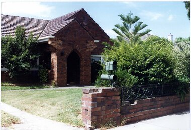
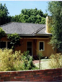
Originally labelled "Beauville Estate, Established 1936, Still Thriving 65 years on, 10th March 2001", the Beauville Estate Album contains colour photographs of houses in the Estate. They were taken around the time of the Beauville Estate’s 65th Heritage Celebration held on 10/03/2001 and donated to the Caulfield Historical Society shortly afterwards. Photographer unknown. City of Glen Eira’s Heritage Management Plan Vol 2 p79 (this is p84 of the pdf version) – HO12 Beauville Estate and environs, Murrumbeena: The Beauville Historic Area is important at the State level as the first large housing estate undertaken by the AV Jennings Construction Co, later Jennings Group Limited, Victoria’s largest home builder. It is important also as a very early estate development incorporating a range of features other than houses and including made roads, shops and recreation facilities. In this respect it was the forerunner of the comprehensively planned housing estate of the post war era. The estate is distinguished by its aesthetic values, as is the earlier and comparable Hillcrest Estate, which are formed by a combination of restrained diversity in house styles, with the exception of no. 30 in the emerging International style, and by a landscaped garden environment. Colour photograph of an unpainted variegated brown brick house with decorative brickwork. Other features include tiled roof, enclosed porch with an arched entrance and black metal lantern and open window on the left side , garden, drive and a low slightly damaged unpainted brick fence with cast iron work railing in the foreground with a cast iron work letterbox on top.11murrumbeena, houses, architectural styles, 1930's, inter war style, a.v. jennings, av jennings, jennings, brick houses, beauville estate, dalny road, porches, sir albert victor jennings, a v jennings construction co, beauville estate heritage area, glen eira city council, architectural features, jennings group limited, land subdivision, gardens, beauville historic area, brick features, arches, cast iron work, letterboxes, brick walls -
 Glen Eira Historical Society
Photograph, Dalny Road, 15, Murrumbeena, 2001
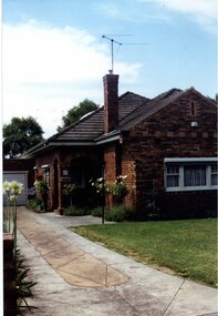
Originally labelled "Beauville Estate, Established 1936, Still Thriving 65 years on, 10th March 2001", the Beauville Estate Album contains colour photographs of houses in the Estate. They were taken around the time of the Beauville Estate’s 65th Heritage Celebration held on 10/03/2001 and donated to the Caulfield Historical Society shortly afterwards. Photographer unknown. City of Glen Eira’s Heritage Management Plan Vol 2 p79 (this is p84 of the pdf version) – HO12 Beauville Estate and environs, Murrumbeena: The Beauville Historic Area is important at the State level as the first large housing estate undertaken by the AV Jennings Construction Co, later Jennings Group Limited, Victoria’s largest home builder. It is important also as a very early estate development incorporating a range of features other than houses and including made roads, shops and recreation facilities. In this respect it was the forerunner of the comprehensively planned housing estate of the post war era. The estate is distinguished by its aesthetic values, as is the earlier and comparable Hillcrest Estate, which are formed by a combination of restrained diversity in house styles, with the exception of no. 30 in the emerging International style, and by a landscaped garden environment. Colour photograph of an unpainted variegated brown brick house and garage with decorative brickwork. Other features include tiled roof, porch, tall feature chimney with a TV aerial attached, white-framed sash windows, awnings, white garage door and a concrete driveway.15murrumbeena, houses, architectural styles, 1930's, inter war style, a.v. jennings, av jennings, jennings, brick houses, beauville estate, dalny road, sir albert victor jennings, a v jennings construction co, beauville estate heritage area, glen eira city council, architectural features, jennings group limited, land subdivision, gardens, beauville historic area, brick features, garages (private), porches, arches, chimneys, sash windows, drives, awnings -
 Glen Eira Historical Society
Photograph, Dalny Road, 15, Murrumbeena, 2001
Originally labelled "Beauville Estate, Established 1936, Still Thriving 65 years on, 10th March 2001", the Beauville Estate Album contains colour photographs of houses in the Estate. They were taken around the time of the Beauville Estate’s 65th Heritage Celebration held on 10/03/2001 and donated to the Caulfield Historical Society shortly afterwards. Photographer unknown. City of Glen Eira’s Heritage Management Plan Vol 2 p79 (this is p84 of the pdf version) – HO12 Beauville Estate and environs, Murrumbeena: The Beauville Historic Area is important at the State level as the first large housing estate undertaken by the AV Jennings Construction Co, later Jennings Group Limited, Victoria’s largest home builder. It is important also as a very early estate development incorporating a range of features other than houses and including made roads, shops and recreation facilities. In this respect it was the forerunner of the comprehensively planned housing estate of the post war era. The estate is distinguished by its aesthetic values, as is the earlier and comparable Hillcrest Estate, which are formed by a combination of restrained diversity in house styles, with the exception of no. 30 in the emerging International style, and by a landscaped garden environment. Colour photograph of an unpainted variegated brown brick house with decorative brickwork. Other features include tiled roof, double-arched porch, 2 tall feature chimneys, white-framed sash windows, awnings, a concrete driveway and a trimmed hedge with an unpainted low brown brick pillar and fence in the foreground.15murrumbeena, houses, architectural styles, 1930's, inter war style, a.v. jennings, av jennings, jennings, brick houses, beauville estate, dalny road, porches, sir albert victor jennings, a v jennings construction co, beauville estate heritage area, glen eira city council, architectural features, jennings group limited, land subdivision, gardens, beauville historic area, brick features, arches, chimneys, sash windows, awnings, brick fences, hedges -
 Glen Eira Historical Society
Photograph, Dalny Road, 23, Murrumbeena, 2001
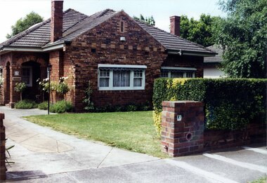
Originally labelled "Beauville Estate, Established 1936, Still Thriving 65 years on, 10th March 2001", the Beauville Estate Album contains colour photographs of houses in the Estate. They were taken around the time of the Beauville Estate’s 65th Heritage Celebration held on 10/03/2001 and donated to the Caulfield Historical Society shortly afterwards. Photographer unknown. City of Glen Eira’s Heritage Management Plan Vol 2 p79 (this is p84 of the pdf version) – HO12 Beauville Estate and environs, Murrumbeena: The Beauville Historic Area is important at the State level as the first large housing estate undertaken by the AV Jennings Construction Co, later Jennings Group Limited, Victoria’s largest home builder. It is important also as a very early estate development incorporating a range of features other than houses and including made roads, shops and recreation facilities. In this respect it was the forerunner of the comprehensively planned housing estate of the post war era. The estate is distinguished by its aesthetic values, as is the earlier and comparable Hillcrest Estate, which are formed by a combination of restrained diversity in house styles, with the exception of no. 30 in the emerging International style, and by a landscaped garden environment. Colour photograph of a cream rendered brick house with unpainted decorative variegated brown brick features including on the porch and chimney. Other features include tiled roof, sash windows, concrete path, garden pots, established garden and a low unpainted lighter variegated brown brick fence in the foreground with '23' on the left hand pillar beside the black cast iron work gate. 23murrumbeena, houses, architectural styles, 1930's, inter war style, a.v. jennings, av jennings, jennings, brick houses, beauville estate, dalny road, porches, brick features, sir albert victor jennings, a v jennings construction co, beauville estate heritage area, glen eira city council, architectural features, jennings group limited, land subdivision, gardens, beauville historic area, chimneys, sash windows, brick fences, cast iron work gates, rendered houses -
 Glen Eira Historical Society
Photograph, Dalny Road, 25, Murrumbeena, 2001
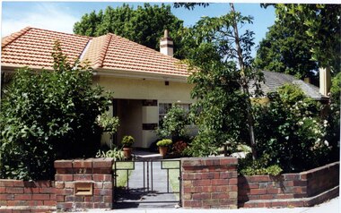
Originally labelled "Beauville Estate, Established 1936, Still Thriving 65 years on, 10th March 2001", the Beauville Estate Album contains colour photographs of houses in the Estate. They were taken around the time of the Beauville Estate’s 65th Heritage Celebration held on 10/03/2001 and donated to the Caulfield Historical Society shortly afterwards. Photographer unknown. City of Glen Eira’s Heritage Management Plan Vol 2 p79 (this is p84 of the pdf version) – HO12 Beauville Estate and environs, Murrumbeena: The Beauville Historic Area is important at the State level as the first large housing estate undertaken by the AV Jennings Construction Co, later Jennings Group Limited, Victoria’s largest home builder. It is important also as a very early estate development incorporating a range of features other than houses and including made roads, shops and recreation facilities. In this respect it was the forerunner of the comprehensively planned housing estate of the post war era. The estate is distinguished by its aesthetic values, as is the earlier and comparable Hillcrest Estate, which are formed by a combination of restrained diversity in house styles, with the exception of no. 30 in the emerging International style, and by a landscaped garden environment. Colour photograph of a light tan rendered brick house with a small curved additional roof jutting over the front door. Other features include tiled roof, white framed windows, door and guttering, feature chimney and a low unpainted variegated brown brick fence in the foreground with bushes and lawn behind the fence. Tall trees behind the house.murrumbeena, houses, architectural styles, 1930's, inter war style, a.v. jennings, av jennings, jennings, brick houses, beauville estate, dalny road, sir albert victor jennings, a v jennings construction co, beauville estate heritage area, glen eira city council, architectural features, jennings group limited, land subdivision, gardens, beauville historic area, rendered houses, chimneys, brick fences -
 Glen Eira Historical Society
Photograph, Dalny Road, 13, Murrumbeena, 2001
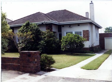
Originally labelled "Beauville Estate, Established 1936, Still Thriving 65 years on, 10th March 2001", the Beauville Estate Album contains colour photographs of houses in the Estate. They were taken around the time of the Beauville Estate’s 65th Heritage Celebration held on 10/03/2001 and donated to the Caulfield Historical Society shortly afterwards. Photographer unknown. City of Glen Eira’s Heritage Management Plan Vol 2 p79 (this is p84 of the pdf version) – HO12 Beauville Estate and environs, Murrumbeena: The Beauville Historic Area is important at the State level as the first large housing estate undertaken by the AV Jennings Construction Co, later Jennings Group Limited, Victoria’s largest home builder. It is important also as a very early estate development incorporating a range of features other than houses and including made roads, shops and recreation facilities. In this respect it was the forerunner of the comprehensively planned housing estate of the post war era. The estate is distinguished by its aesthetic values, as is the earlier and comparable Hillcrest Estate, which are formed by a combination of restrained diversity in house styles, with the exception of no. 30 in the emerging International style, and by a landscaped garden environment. Colour photograph of a white rendered brick house with decorative unpainted variegated brown brick features including a panel and column. Other features include tiled roof, porch, 2 tall rendered chimneys, concrete driveway, variegated brown brick garage with white door and a low unpainted matching brick fence in the foreground with established bushes and lawn behind.13murrumbeena, houses, architectural styles, 1930's, inter war style, a.v. jennings, av jennings, jennings, brick houses, beauville estate, dalny road, sir albert victor jennings, a v jennings construction co, beauville estate heritage area, glen eira city council, architectural features, jennings group limited, land subdivision, gardens, beauville historic area, rendered houses, brick features, porches, chimneys, garages (private), brick fences -
 Glen Eira Historical Society
Album - Album page, Ripponlea, 192 Hotham Street, Circa 1972
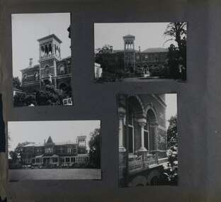
This photograph is part of the Caulfield Historical Album 1972. This album was created in approximately 1972 as part of a project by the Caulfield Historical Society to assist in identifying buildings worthy of preservation. The album is related to a Survey the Caulfield Historical Society developed in collaboration with the National Trust of Australia (Victoria) and Caulfield City Council to identify historic buildings within the City of Caulfield that warranted the protection of a National Trust Classification. Principal photographer thought to be Trevor Hart, member of Caulfield Historical Society. Most photographs were taken between 1966-1972 with a small number of photographs being older and from unknown sources. All photographs are black and white except where stated, with 386 photographs over 198 pages.From Victorian Heritage Database citation for Rippon Lea H0614 https://vhd.heritagecouncil.vic.gov.au/places/427(as at 23/10/2020) Rippon Lea was commenced in 1868 by Frederick Sargood, a most successful politician and merchant. He was born in England in 1834 and arrived in Melbourne in 1850. He soon joined his father's wholesale soft goods firm, spending some time as its manager on the goldfields. Sargood entered the Legislative Council in 1874. He was Victoria?s first Minister for Defence in 1883. Sir Frederick Sargood was created CMG. In 1885 and KCMG in 1890 as a reward for his contribution to public life. He died suddenly in 1903. Rippon Lea was designed by the leading firm of architects, Reed and Barnes. Joseph Reed had travelled in Europe in 1863, including northern Italy. When he returned he introduced the use of polychromy. While not the first examples, Rippon Lea and the Independent Church in Collins Street were the best and set a fashion which became a distinctly Melbourne style, particularly used for houses and churches. Its popularity was possible because of the new availability of different coloured bricks. Reed's fine Lombardic Romanesque details soon became debased by others. As Sargood's family grew and his fortunes prospered, Rippon Lea was extended to include 33 rooms - a complete mansion. The cast iron porte cochere and the northern conservatory were added in 1897. The architects were Taylor and Fitts. The ballroom was added in 1882 and remodelled in 1889. Many alterations have changed the interior and exterior during the ownerships of Benjamin Nathan and later his daughter Mrs Louisa Jones in the 1930s and are in their own right of significance. Sir Thomas Bent owned the property from 1903 until 1911 but never lived there. He subdivided much of the land. The original garden dates from about 1868, and it seems that William Guilfoyle of the Botanic Gardens was involved. It was redesigned in a more natural style in the 1880s by Sargood and his head gardener, Adam Anderson. The lake, waterfalls, fernery, hill and grotto are balanced by mighty deciduous trees and conifers. These are interspersed with, but never dominated by Australian species such as eucalyptus and other exotics. The sinuous drive with its carefully prepared approach to the house is notable. The original vegetable gardens, orchard and outer paddocks no longer survive. The shade house is important as the largest known in Australia and possibly the world. Its curved plan and form of construction are particularly notable. It was built about 1884.Page 91 of Photograph Album with four photographs (two portrait and two landscape) of various external views of Ripponlea.Handwritten: SOUTH [under top left photo] / SOUTH [under top right photo] / WEST [under bottom left photo] / 91 [bottom left]trevor hart, elsternwick, mansion, hotham street, frederick sargood, reed and barnes, cast iron porte cochere, conservatory, 1860's, 1890's, ballroom, 1880's, benjamin nathan, louisa jones, thomas bent, sir thomas bent, william guilfoyle, adam anderson, lake, grotto, shade house, portico, ripponlea, victorian, sir frederick sargood, architects, taylor and fitts, rippon lea, polychrome bricks, lombardic romanesque style -
 Ringwood and District Historical Society
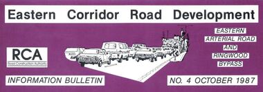
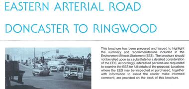
Newsletter, Eastern Arterial Road and Ringwood Bypass Information Bulletin - October 1987
Tri-fold A4 size brochure (6 pages) issued by Road Construction Authority reporting on specialist studies currently being undertaken for the Eastern Corridor Road Development investigations. Topics include Air Quality Study, Landscape and Recreation, Public Transport Study, Bypass Preferred Route, Long Term Access Strategy, Road Design. A government decision on the road development strategy proposal public exhibition commencing in November 1987 for 4 months could be made later in 1988. -
 Ringwood and District Historical Society
Newsletter, Eastern Arterial Road Doncaster to Ringwood Environment Effects Statement Summary Brochure - November 1987
8-page A4 size brochure issued by Road Construction Authority reporting on the proposed extension of the Eastern Freeway between Doncaster and Ringwood. Topics include Community Consultation, Initial Four Lane Development, Estimated Capital Costs, Traffic Effects, Public Transport, Landscape Creek and Visual Aspects, Pedestrian/Bicycle Access, Noise, Air Quality, Lighting, Construction Impacts. -
 Ringwood and District Historical Society
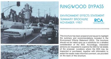
Newsletter, Ringwood Bypass Environment Effects Statement Summary Brochure - November 1987
8-page A4 size brochure issued by Road Construction Authority reporting on the proposed Ringwood Bypass. Topics include Community Consultation, Estimated Capital Costs, Traffic Effects, Property Effects, Mullum Mullum Creek, Landscape Development, Pedestrian/Bicycle Access, Noise, Air Quality, Compatability with Ringwood District Centre Development, Vehicle & Traffic Aspects, Lighting, Construction Impacts, Extension to Canterbury Road, Public Transport. -
 Bendigo Historical Society Inc.
Slide - RALPH BIRRELL COLLECTION: EIG SCHOOL, c1966
EIG School - Ralph Birrell Collection. - Construction of Latrobe Uni. C1967. Bendigo Institute of Technology, Engineering School, Applied Science. Bull dozer landscaping the area at LaTrobe University.Kodakeducation, tertiary, latrobe university bendigo, eig school - ralph birrell collection. - construction of latrobe uni. c1967. bendigo institute of technology, engineering school, applied science. bull dozer landscaping latrobe university -
 Bendigo Historical Society Inc.
Photograph - RAILWAYS COLLECTION: RAILWAY BRIDGES AND VIADUCTS
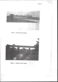
RAILWAYS COLLECTION -6 x Unbound Photocopied double sided pages giving information on the construction of the Bendigo Railway Line including Black and white photos of Railway Bridges and Viaducts - which show the Saltwater River bridge , Jacksons Creek Viaduct, Riddell Creek Bridge, Campbell's Creek Road bridge, Forest creek viaduct and Malmsbury Viaduct the photos are grainy in appearance.photograph, landscape -
 Bendigo Historical Society Inc.
Slide - RALPH BIRRELL COLLECTION: EIG SCHOOL, c1966
EIG School - Ralph Birrell Collection. - Construction of Latrobe Uni. C1966, 1972. Bendigo Institute of Technology, Engineering School, Applied Science. View of building with round theatre behind it. Landscaping yet to be done.Kodakeducation, tertiary, latrobe university bendigo, eig school - ralph birrell collection. - construction of latrobe uni. c1966, 1977. bendigo institute of technology, engineering school, applied science. building round theatre behind landscaping no done -
 Monbulk RSL Sub Branch
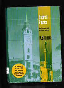
Book, Melbourne University Press, Sacred places : war memorials in the Australian landscape, 2008
After the slaughter of the First World War, Australians embarked on a remarkable programme of war memorial construction. These memorials, large and small, stand everywhere in the Australian landscape. They embody what Australians have wanted to say about the service and death of their compatriots in overseas wars. They express pride, grief, and perceptions of God, empire and nation, becoming the holy sites of a new civil and nationalist religion -- the cult of Anzac." "In this moving and beautifully written book, award-winning historian Ken Inglis traces the development of the Anzac cult, as well as looking at those who rejected it. Sacred Places also examines a paradox: why, as Australia's wars recede in memory, have these memorials and what they stand for become more cherished than ever? In this updated third edition, that question is pursued into the first decade of a new century.Index, notes, ill, p.640.non-fictionAfter the slaughter of the First World War, Australians embarked on a remarkable programme of war memorial construction. These memorials, large and small, stand everywhere in the Australian landscape. They embody what Australians have wanted to say about the service and death of their compatriots in overseas wars. They express pride, grief, and perceptions of God, empire and nation, becoming the holy sites of a new civil and nationalist religion -- the cult of Anzac." "In this moving and beautifully written book, award-winning historian Ken Inglis traces the development of the Anzac cult, as well as looking at those who rejected it. Sacred Places also examines a paradox: why, as Australia's wars recede in memory, have these memorials and what they stand for become more cherished than ever? In this updated third edition, that question is pursued into the first decade of a new century.war memorials - australia, soldiers memorials - australia -
 Buninyong & District Historical Society
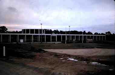
Photograph - Original Photograph of site of BIAE, Ballarat Institute of Advanced Education (Federation University), 1968
Colour photograph of construction site of Ballarat Institute of Advanced Education 1968The construction of the Mt. Helen campus in the 1970s was an important milestone in the expansion of tertiary education in the Central HighlandsColour photograph of Ballarat Institute of Advanced Education construction site 1968Mt. Helen Site, Beginnings of BIAEeducation, ballarat institute of advanced education, federation university, landscape, mt. helen -
 Buninyong & District Historical Society
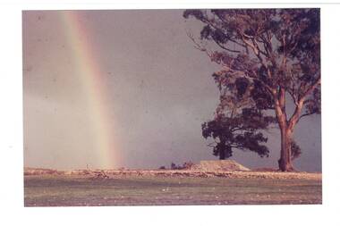
Photograph - Photograph colour of Green Hill, View of Green Hill from Ballarat Institute of Advanced Education (Federation University) site, 1968
Colour photograph of site of Ballarat Institute of Advanced Education 1968 showing Green HillThe construction of the Mt. Helen campus in the 1970s in the predominately rural area was an important milestone in the expansion of tertiary education in the Central HighlandsColour photograph from Ballarat Institute of Advanced Education construction site toward Green Hill 1968Mt. Helen Site - Eastern end towards Green Hill 1968education, ballarat institute of advanced education, federation university, landscape, mt. helen, green hill -
 Buninyong & District Historical Society
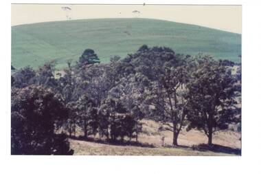
Photograph - Photograph colour of site of Mt Helen Ballarat Institute of Advanced Education 1968, View of Ballarat Institute of Advanced Education (Federation University) site Mt Helen, 1968
Colour photograph of site of Ballarat Institute of Advanced Education 1968 showing Mount BuninyongThe construction of the Mt. Helen campus in the 1970s in the predominately rural area was an important milestone in the expansion of tertiary education in the Central HighlandsColour photograph of Ballarat Institute of Advanced Education site Mt Helen toward Mount Buninyong1968Mt. Helen - Towards Mt Buninyong from N.W. 1968 Before Campus Beginseducation, ballarat institute of advanced education, federation university, landscape, mt. helen, mount buninyong -
 Tatura Irrigation & Wartime Camps Museum
Photograph, Goulburn Waranga Main Channel Construction, 1957
Taken by photographer for State Rivers and Water Supply Commission.Large black and white photograph dry mounted on to cream board. Landscape scene depicting newly excavated ground with solitary man within scene.Below photograph: "GOULBURN WARANGA MAIN CHANNEL CONSTRUCTION / CHANNEL EXCAVATION AND BEACHING / LOOKING DOWNSTREAM" victoria state rivers and water supply commission, goulburn waranga main channel, goulburn, waranga -
 Robin Boyd Foundation
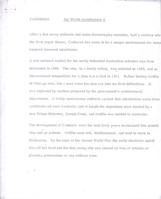
Document - Manuscript, Robin Boyd, Canberra, 1967
Boyd outlines the history of Canberra's design and construction. He argues that Canberra's strength is its planning and axially-based landscaping, but that it lacks the buildings which make the Le Corbusier's Chandigarh interesting. Boyd is highly critical of Chandigarh as an urban environment and concludes that for non-architects, planning and connection to nature is more important than buildings.Original manuscript published as 'Canberra Master Plan: Walter Burley Griffin' in World Architecture 4, John Donat (ed.), Viking Press 1967, pp 202-205.Typewritten (p/copy), quarto, 6 pageswalter burley griffin, canberra, john overall, lake burley griffin, oscar niemeyer, le corbusier, chandigarh, city beautiful, garden city, urban planning, robin boyd, manuscript -
 Hume City Civic Collection
Photograph, c 1978
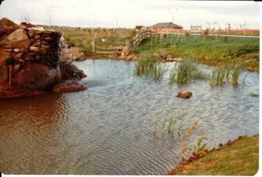
On 4th August 1978 the construction of the Goonawarra Estate commenced. The estate was formerly known as the Goonawarra Farm and overlooked the Sunbury Township and the Jacksons Creek Valley. Plans for the development included a golf course, houses and community and recreational facilities. The golf course opened in 1980 and the housing construction continued throughout the last two decades of the twentieth century and into the twenty first century.A coloured photograph of the reflecting pool at the entrance of the Goonawarra Golf Club. The surrounding area has been landscaped and a display home is in the distance.goonawarra golf club, goonawarra farm, goonawarra housing estate, housing developments, sharkey, robert b., kilkenny homes, australian ideas homes pty.ltd., glamor homes, craftsmen homes., villa bella homes, george evans collection -
 Hume City Civic Collection
Photograph, 1/11/1980
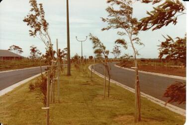
On 4th August 1978 the construction of the Goonawarra Housing Estate commenced. The estate was formerly known as the Goonawarra Farm and overloked the Sunbury town area and Jacksons Creek valley. Plans for the new development included a gold course, housing, community and recreational facilities. The construction continued througout the last two decades of the twentieth century and into the twenty first century.A coloured photograph of Francis Boulevard at the Goonawarra Estate showing the entrances and landscaping and looking south to Sunbury Road and Jacksons Hill (Sheoak Hill).goonawarra farm, goonawarra golf club, goonawarra housing estate, kilkenny homes, craftsmen homes., australian ideas homes pty.ltd., villa bella homes, glamor homes, george evans collection -
 Nillumbik Shire Council
Painting: Walter WITHERS (b.1854 Warwickshire, UK — d.1914 Eltham, Aus), Trestle Bridge, Eltham, c.1903-10
Walter Withers was a significant Australian landscape artist and a member of the Heidelberg School of Australian Impressionists. In 1903 Withers bought 'Southernwood', a house on 2½ acres (1 ha) at Eltham, to which he added a studio. Because of ill health, he lived during the week at his studio in Oxford Chambers, Melbourne, and on weekends and holidays with his family at Eltham until his death in 1914. The Eltham rail bridge is a unique and valuable historic relic of an earlier steam locomotive transport era in the Diamond Creek Valley and has long formed an important part of a magnificent Eltham landscape. When built in 1902 it was close to the terminus point of the Heidelberg-Eltham rail extension, on the route of the proposed Diamond Valley Railway that was then planned to continue much further up the valley towards Kinglake. This bridge is situated in attractive river-valley parkland amidst the tall and spreading manna gums and candlebarks of the Diamond Creek Valley. The Alistair Knox Park river-valley landscape, of which the timber trestle bridge is an important visual component, has been classified by the National Trust. Large manna gum and candlebark trees adorn the adjacent creek banks, and historic Shillinglaw Cottage is also part of this much-prized Eltham landscape. Eltham is home to a historic wooden railway trestle bridge. Mainly of timber-pier and timber-beam construction, but varied by a few longer steel-joists spans on timber piers at the main stream channel, this substantial bridge has almost two hundred metres of timber deck. Built in 1902, it is the only railway bridge of predominantly timber construction that is still in regular use as an integral part of Melbourne's metropolitan electric railway network and one of extremely few timber rail bridges in the State that still carry trains. Apart from its important continuing social function as a carrier of rail transport for the Hurstbridge line, this impressive bridge and its beautiful parkland environs contribute much to the character of Eltham township and that town's special reputation as an historic centre of environmental and conservation concerns. This section of the Diamond Creek Valley was the subject of a Walter Withers painting in the earliest years of the twentieth century and has strong historic links with our Heidelberg School of painters. Watercolour painting on paper of Eltham's Trestle Bridge in the middle of the day. A small section of the wooden bridge is located to the left of the painting. The focus is predominately on the wattle, manna gum and candlebark trees that is to the right of the bridge. The golden hues typically represent the australian sunlight and landscape. "W.W" in gothic script on the lower right side of the painting. Not dated. withers, eltham, trestle bridge, railway, watercolour -
 Nillumbik Shire Council
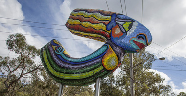
Public Art: Deborah HALPERN, 'Queen of the Shire'; Location: Cnr Kangaroo Ground-Warrandyte Rd & Research-Warrandyte Rd, North Warrandyte, 2015
Deborah Halpern was raised in Nth Warrandyte. Her connection to the area and the significant contribution that she and her family (founding members of Potters Cottage) have made to the artistic heritage and culture of the Shire is acknowledge with the commission of this piece. Deborah Halpern is a highly recognised and respected local artist with an acclaimed national reputation in the arts community. This work is a gateway piece, welcoming residents and visitors into the Shire from the southern end of the boundary. 'Queen of the Shire' reflects the creative spirit that flows endlessly in the Shire, inspired by the landscape. This work forms part of a series of sculptures that Halpern has created along the banks of the Yarra in Melbourne ('Angel' - Birrarung Marr and 'Ophelia' - Southgate). This sculpture is an excellent example of Halpern’s ouvere and 'tile construction' technique for which she is renowned. Materials: coloured glass tiles, fibreglass, aluminium, steel. A sweeping stylised (female) form covered in bright and colourful tiles held aloft by two steel poles. queen, sculpture, semi-abstract, stylised, glass, tiles, public art, halpern, ek prac 2015 -
 Ballarat Heritage Services
Photograph - Colour, Bessibelle Drystone Sheep Wash, 2016, 24/04/2016
The Bessiebelle Sheepwashes and Yards complex is located on the former 14,000 acre Ardonachie Run, established in 1848 by pastoralist Samuel Gorrie, then carrying 6,000 sheep. In 1864 this run was subdivided into smaller runs, and the sheep washes were located within Mount Eccles and Lake Gorrie Run. The date of construction of the washes and walls is not known, although they were probably constructed within the period 1848-1864. The Bessiebelle Sheepwashes and Yards are probably the largest and most sophisticated surviving example of a traditional pastoral property sheepwash in Victoria. They clearly demonstrate the large network of races, yards and folds necessary for washing thousands of sheep over a short period of time. The Bessiebelle sheep washes apparently predate later technological changes and the necessity for hot water washing. The Bessiebelle sheepwashes and yards are of landscape significance as a cultural landscape which has been both modified by, and cleverly adapted to, an annual process that was of critical importance within the pastoral calendar. The drystone walls and races appear to evolve from the rocky terrain, and have a strong organic affinity with the prevailing harsh landscape. The drystone walls demonstrate a high level of craftsmanship and skill in their construction, and reflect the extensive scale of pastoral operations across the landscape. The Bessiebelle sheepwashes and yards are of archaeological significance to the State of Victoria. The site has not been fully surveyed but its complexity strongly suggests a potential to reveal more about the washing processes and associated pastoral occupation and activity in the area.(Heritage Victoria)drystone, bessibell, sheep race, sheep wash, agriculture -
 Ballarat Tramway Museum
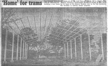
Newspaper, The Courier Ballarat, " 'Home' for trams", 16/05/1972 12:00:00 AM
Yields information about the construction of the depot building for the BTPS in the south Gardens Reserve and the landscape at the time.Newspaper clipping from The Courier, Ballarat, dated Tuesday, 16/5/1972 titled " 'Home' for trams". Features a photograph of the erected steelwork for the new BTPS tram depot in the South Gardens Reserve. One of a large group of newspaper cuttings from John Bainbridge, 7/4/02. See Reg Item 3819 for a print of the actual photograph.btps, depot, buildings -
 Ballarat Tramway Museum
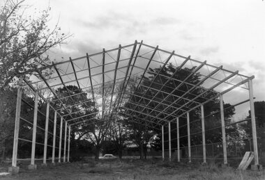
Photograph - Black & White Photograph/s, The Courier Ballarat, 15/5/1972
Newspaper photograph taken by The Courier of the steel framework for the BTPS depot in the south Gardens reserve. Photo taken 15/5/1972, published 16/5/1972. See Reg. Item 2203 for the photo used in the newspaper clipping. Collected by Alan Bradley from the Ballarat Courier early 1980's. See Reg Item 4654 for a similar photo, along with 9434, and 3819.Yields information about the construction of the depot building for the BTPS in the south Gardens Reserve and the landscape at the time.Black and White copy photograph with publisher details on the rear.On rear stamped "Copyright, The Ballarat Courier Proprietary Limited."tramways, trams, btps, depot, gardens, buildings -
 Ballarat Tramway Museum
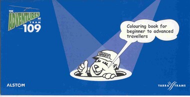
Domestic object - Colouring Book, Yarra Trams and Warwick Hook, "The Adventures of Tram 109", Dec 2003?
12 page colouring book, with heavy card covers, titled "The Adventures of Tram 109", with illustrations by Warwick Hook, published at the time of the opening to Box Hill of route 109 from Mont Albert. Published jointly by Alstom and Yarra Trams. Features 10 pages of landscape size cartoons each featuring a single story line and a four panel cartoon, with a title and Harry the construction worker panel at the ends. Has Yarra trams logo and web site on the rear cover.tram, trams, box hill, yarra trams, route 109 -
 Ballarat Tramway Museum
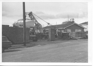
Photograph - Black & White Photograph/s - set of 2, mid 1972
Yields information about the construction of the depot building for the BTPS in the south Gardens Reserve and the landscape at the time.Black and white photograph of the bike or bicycle shed at the old SEC Depot Ballarat being lifted by a Bob Davies crane onto a truck for transport front the depot mid 1972 - part of the demolition work undertaken at the depot. Possibly one of the last buildings to be removed. trams, tramways, depot, bike shed, demolition -
 Kew Historical Society Inc
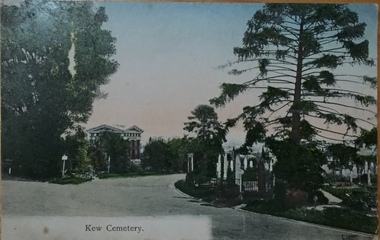
Postcard, Unknown, Kew Cemetery, 1905
This view of the Boroondara General (Kew) Cemetery is dated to 1905 by the inscription and postmark on the reverse. It provides an important visual record of this part of the Cemetery. The postcard can be used to identify the original configuration of the roads and vegetation, some of which was subsequently removed (eg the bunya pine at right). On the Victorian Heritage Database, the construction period given for the Springthorpe Memorial is given as 1897-1907, yet this view of the Memorial in 1905 would suggest that it was virtually completed at an earlier date. (It should be noted that additions such as the wheel of life sculpture were not completed until 1910).This dated photograph is historically important as its inscription confirms it to be one of the earliest postcard representations of the Boroondara General (Kew) Cemetery. It also provides visual evidence of the size and extent of the landscaping by 1905, particularly the layout of the roads (now altered), plantings of the period, and the extent of the land occupied by the Springthorpe Memorial and its gardens, which was subsequently reduced by the trustees of the cemetery in the 1930s. Panoramic view of the entrance driveway in Boroondara General (Kew) Cemetery. At left can be seen the Springthorpe Memorial, and further down on the left the entrance gate, or one of the gates, to the Memorial. Inscribed on reverse: "Miss Brown / Shuan [sic] / Grosvenor Street / M. Brighton. Love from Mother Oct 28th 1905" Postmark: "Melbourne 8 / 2 PM, 28/10/05".springthorpe memorial, boroondara general (kew) cemetery, postcards -- cemeteries -
 Kew Historical Society Inc
Photograph, J F C Farquhar, Railway Bridge Over the Yarra, 1891
At the beginning of the 1890s, the Kew businessman and Town Councillor, Henry Kellett, commissioned J.F.C. Farquhar to photograph scenes of Kew. These scenes included panoramas as well as pastoral scenes. The resulting set of twelve photographs was assembled in an album, Kew Where We Live, from which customers could select images for purchase.The preamble to the album describes that the photographs used the ‘argentic bromide’ process, now more commonly known as the gelatine silver process. This form of dry plate photography allowed for the negatives to be kept for weeks before processing, hence its value in landscape photography. The resulting images were considered to be finely grained and everlasting. Evidence of the success of Henry Kellett’s venture can be seen today, in that some of the photographs are held in national collections.It is believed that the Kew Historical Society’s copy of the Kellett album is unique and that the photographs in the book were the first copies taken from the original plates. It is the first and most important series of images produced about Kew. The individual images have proved essential in identifying buildings and places of heritage value in the district.Completed in November 1890, the railway viaduct (now the Chandler Highway Bridge) linked Kew and Fairfield. The viaduct is significant as the most substantial extant engineering remnant of the Outer Circle Railway Line. Opened in March 1891, the viaduct crossed the Yarra River in a single span, atop three supporting brick pillars. Following the closure of the railway line in 1927, and the construction of the Chandler Highway in 1930, the bridge was used for vehicular traffic. In 1891 when this panoramic photograph was taken, the grounds of what was then the Kew Lunatic Asylum extended down to the River and eastward beyond the viaduct. The landscape surrounding the Asylum was planted with traditional exotic trees such as Oaks, Pines and Cedars, and landmark trees from northern Australia such as the Hoop Pine. Remnant indigenous trees such as the River Red Gum, Yellow Box and Lightwood were scattered around the site, including beside the Yarra River.Railway Bridge Over the Yarrakew illustrated, kew where we live, photographic books, henry kellett, railway viaduct - - kew (vic)