Showing 420 items
matching localities
-
 Glen Eira Historical Society
Document - Nithsdale
Photocopied copy of flyer for forthcoming subdivision of Caulfield Heights Estate on 27/10/1888. Includes locality plan and subdivisions. Photocopied copy of flyer for forthcoming sale of properties and mansion, Nithsdale on 18/09/1889, includes map of area.carriages and coaches, caulfield heights estate, caulfield north, maxwell grove, kambrook road, neerim road, blake street, bambra road, racecourse road, auctioneers, station street, glen eira road, paynes j., mansion, beauchamp brothers -
 Bendigo Historical Society Inc.
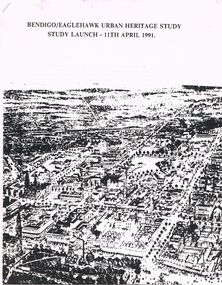
Document - BENDIGO/EAGLEHAWK URBAN HERITAGE STUD: STUDY LAUNCH 11TH APRIL 1991, 11/04/1991
Bendigo/Eaglehawk Urban Heritage Study - Study Launch 11th April 1991. Three page document with attachments and appendices. Details of Purpose of the Study; Management of the Study (including names of consultants); budget area, strategy, timing etc. Three pages (illustrated of places to visit (46 numbered localities); map of Eaglehawk with 24 numbered locations; Appendices.City of Bendigo, Borough of Eaglehawk, The Historic Buildings Council, Victoria National Estate Committeebendigo, council, heritage study, heritage study, bendigo, eaglehawk. historic building council, victoria national building committee. -
 Ringwood and District Historical Society
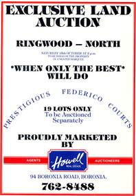
Pamphlet, Land Auction Brochure - Federico Courts Estate, Ringwood North, Vic. Circa 1988
Bifold brochure advertising auction of 19 residential allotments on Saturday 15th October, (1988?). Brochure includes terms of sale, description of subdivision features and local facilities, with locality map. Subdivision includes Federico Court and Gilston Way, Ringwood North. Agents/Auctioneers - B.S. Howell Real Estate, 94 Boronia Road, Boronia, (Phone) 762 8488. -
 Bendigo Historical Society Inc.
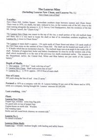
Document - THE LAZARUS MINE - NOTES ON THE THE LAZARUS MINE
One siix page handwritten and three typed copies of notes on the The Lazarus Mine including the Lazarus New Chum and the Lazarus No 1 on the New Chum Line of Reef. Notes include locality, depth of shafts, size of lease, plant, early history, the Lazarus Company, Prominence, Best Gold and Total Gold Yields. Notes prepared by Albert Richardson.document, gold, the lazarus mine, the lazarus mine, notes on the the lazarus mine, lazarus new chum, lazarus no 1, australian headquarters survey unit, george lansell, new chum hill, b c v 8 studios, sheepshead, central red white & blue, mr lazarus, lansell's 222, old chum mine, lazarus company, mr george gibbs, lansell's fortuna, ballerstedt, mr barnet lazarus, the black lead, the white lead, mount alvernia hospital, mines dept special edition 'australian mining standard' 1/6/1899, mines dept booklet 'bendigo goldfield' 1936, mines dept annual and quarterly reports, annals of bendigo mining sections 1868 - 1910, a richardson, the bendigo goldfield registry j n macartney 1/3/1871 -
 Bendigo Historical Society Inc.
Document - NEW CHUM RAILWAY MINE - NOTES ON THE NEW CHUM RAILWAY MINE
Typed copies of handwritten notes on the New Chum Railway Mine on the New Chum Line of Reef. Notes include depth of shaft (4,318 feet), Size of lease, locality, plant - includes poppet legs,winding engine, two engine houses, crushing battery, early history, where the best gold was found, prominence, total gold production and dividends.document, gold, new chum railway mine, new chum railway mine, notes on the new chum railway mine, w d c denovan, mr piper, rourke & henderson's claim, mines dept special edition australian mining standard 1/6/1899, mines dept booklet 'bendigo goldfield' g brown 1936, 'annals of bendigo' mining sections 1890 to 1910, a richardson -
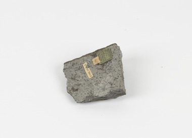 The Beechworth Burke Museum
Geological specimen - Spotted Slate, Unknown
This specimen was recovered from Sedgwick, VIC. Spotted slate is a fine-grained porphyroblastic metamorphic rock with a number of compounds including muscovite, quartz, graphite with cordierite poikiloblasts and more. The cordierite poikiloblasts are rounded crystals that size up to 2.5 mm. the growth of these crystals is in response to metamorphism of low to medium intensity. The town Sedgwick was named after British geologist Adam Sedgwick This specimen is part of a larger collection of geological and mineral specimens collected from around Australia (and some parts of the world) and donated to the Burke Museum between 1868-1880. A large percentage of these specimens were collected in Victoria as part of the Geological Survey of Victoria that begun in 1852 (in response to the Gold Rush) to study and map the geology of Victoria. Collecting geological specimens was an important part of mapping and understanding the scientific makeup of the earth. Many of these specimens were sent to research and collecting organisations across Australia, including the Burke Museum, to educate and encourage further study.A solid rectangular hand-sized spotted slate specimen in a shade of light grey with darker flecks throughout Spotted Slate / Locality: Sedgwick Victoria | This is an early specimen / from the Quarter sheet / map. See sample 62 / page 18. Described as 'Spotted Slate' but these / days we would call it spotted hornfels / C. William 15/4/21 slate, spotted slate, victoria, beechworth, burke museum, geological specimen, mineralogy, sedgwick, sedgwick victoria, spotted slate specimen -
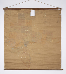 Warrnambool and District Historical Society Inc.
Map - Soldier Settlement Map, Soldier Settlement Commission, Tarrone Estate Alex Boyd, 1940s
This is a map of the Tarrone Soldier Settlement land divisions probably produced by the Soldier Settlement Commission. The map is incomplete with lots 48,49 and 50 missing. The Soldier Settlement Commission purchased 23,373 acres of Tarrone Station from the Boyd brothers in 1947 and the sub divided lots were occupied by soldier settlers commencing in 1949. Tarrone Station was established in 1840 by Doctors Kilgour and Bernard and the Boyd brothers secured the free hold in the 1890s and retained it until 1947. The map hung for many years in the Warrong school near Hawkesdale.This map is of considerable interest as an original item from the establishment of the Tarrone Soldier Settlement..The map is made of brown cloth and creased. The edges are tattered and there is a piece missing at the top. It is a map of allotments, hand drawn and with faded colours in red, blue and yellow. The names of localities and land holders are hand written in ink and chalk. The map is contained within two pieces of wood at the bottom and the top. There are two screws and a cord to hang on a wall. A scale of measurement is shown under the map. tarrone soldiers settlement, boyd brothers tarrone -
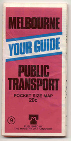 Ballarat Tramway Museum
Map, Ministry of Transport, "Melbourne Public Transport Map" - "No. 9", 1979
Pocket size - folded - public transport map of Melbourne, printed in colour on paper, showing public transport services in greater Melbourne and an index of localities. The Central zone area shown in detail. On the rear, route numbers and line maps of tram routes and train lines or services. Includes private bus routes. Printed for the Ministry of Transport. Issue No. 9. Dated 1979.trams, tramways, melbourne, map, routes -
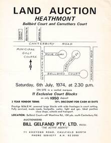 Ringwood and District Historical Society
Flyer - Land Auction, Carruthers Estate, Heathmont, Victoria - 1974
Double-sided page advertising auction of 11 allotments on Saturday, 6th July, 1974, with locality map and plan of subdivision in Carruthers Court and Bellbird Court, Heathmont. $950 deposit, 3 year vendor terms, 10% discount for cash 60 days. Handwritten notation indicating Lot 22 "sold for $127,000 - all other lots passed in around $11,000".Auctioneers - Bill Gelfand Pty. Ltd., R.E.S.I. 71 Kooyong Road, Caulfield North, Phone 5090211 A.H. 523050. -
 Bendigo Historical Society Inc.
Document - NEW CHUM RAILWAY MINE - NOTES ON THE NEW CHUM RAILWAY MINE
Handwritten notes (copy) on the New Chum Railway Mine on the New Chum Line of Reef. Notes include depth of shaft, (At the time, the New Chum Railway Mine and the Victoria Quartz were the deepest in the world), size of lease, locality, plant, engine houses, crushing battery, early history, where the best gold was found, prominence, total gold production and dividends.document, gold, new chum railway mine, new chum railway mine, notes on the new chum railway mine, victoria quartz, great extended hustler's coy, w d c denovan, mr piper, rourke & henderson's claim, young chum reef, thorpe's reef, shenandoah reef, mines dept. special edition australian mining standard 1/6/1899, mines dept booklet bendigo goldfield geo brown 1936, annals of bendigo mining sections 1880 to 1910, a richardson -
 Bendigo Historical Society Inc.
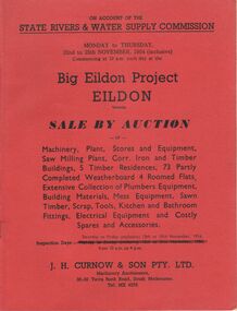
Document - IAN DYETT COLLECTION: AUCTION CATALOGUE - BIG EILDON PROJECT
Two red covered auction catalogues for an auction on account of the State Rivers & Water Supply Commission on the 22nd to 25th November, 1954 (inclusive) held at the Big Eildon Project, Eildon, Victoria. Lots sold include Machinery, plant, stores and equipment, Saw Milling Plant, corr. Iron and timber buildings, 5 timber residences, 73 partly completed weatherboard 4 roomed flats, extensive collection of plumbers equipment, building materials, mess equipment, sawn timber, scrap, tools, kitchen and bathroom fittings, electrical equipment and costly spares and accessories. Catalogue has a Locality Plan of Eildon, photo, locality and description of the Eildon Sawmill. Photos of completed houses, incomplete flats and plan showing layout of flat unit, photo of flat block (Completed). Also Building Kits - Designs and Component Lists.business, auctioneers, j h curnow & son pty ltd, ian dyett collection - auction catalogue - big eildon project, state rivers & water supply commission, j h curnow & son pty ltd, eildon sawmill, prahran telegraph printing co -
 Eltham District Historical Society Inc
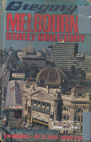
Book, Gregory's Melbourne Street Directory of Melbourne and suburbs and metropolitan road guide (8th edition) extends to Laverton, Deer Park, Epping, Diamond Creek, Lilydale, Olinda, Belgrave, Doveton and Mornington, 1973
This is the 8th edition of Gregory's Melbourne Street Directory, fully revised and up-to-date for this edition published December 1973. It is a comprehensive guide to the streets and localities of Melbourne and suburbs at that time. The colour maps are arranged in double-page spreads. Names of streets and suburbs are arranged alphabetically in the index to streets.Hard copy with plastic cover. 382 p. streets, melbourne - maps, roads -
 Bendigo Historical Society Inc.
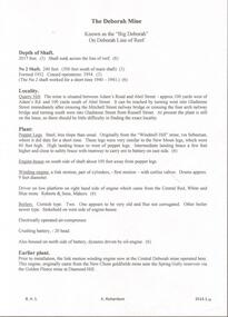
Document - DEBORAH MINE - NOTES ON THE DEBORAH MINE
One hand written notes, one typed and three carbon copies of notes on the Deborah Mine. Notes include depth of shaft, locality, plant, engine house, winding engine, boilers, crushing battery, earlier plant, prominence, best gold, gold yield and dividends. References: Mines Dept. Booklet Bendigo Goldfield 1936, Mines Dept. Quarterly and Annual Reports and A. Richardson.mine, gold, deborah mine, deborah mine, notes on the deborah mine, mines dept. booklet bendigo goldfield 1936, mines dept quarterly and annual reports, a. richardson -
Bendigo Historical Society Inc.
Map - CAMPBELL COLLECTION: BENDIGO AND DISTRICT MAPS, 21-8-1972
Map. Shire of Strathfieldsaye Locality Plan. Scale 1 inch=1 mile. Drawn by M.Higgs 21-8-1972, Shire of Huntly, Shire of McIvor, City of Bendigo, Shire of Marong, Shire of Maldon, Shire of Metcalfe, Lake Eppalock, Axedale Township, Strathfieldsaye Township, Melbourne to Bendigo Railway Line, Big Hill Tunnel, Mt.Herbert 1596. (number 398 in map cupboard 1)M.Higgs 21-8-1972map, bendigo, locality plan -
 Bendigo Historical Society Inc.
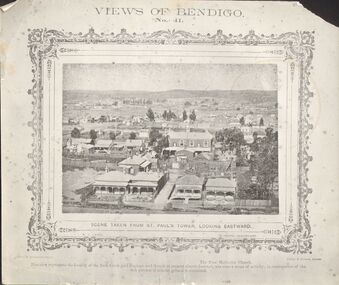
Photograph - DILLON-SHALLARD COLLECTION: VIEWS OF BENDIGO
Views of Bendigo No.41. Scene Taken from St Paul's Tower Looking Eastward. The Free Methodist church. This view represents the locality of the Back Creek gold diggings, and tough at present almost deserted, was once a scene of activity; in consequences of the rich patches of alluvial ground it contained. Photo by N.J. Caire Sandhurst. Casey&Wenborn's Print. On the back a stamp of Ray Dalton BendigoN.J. Cairne -
 Bendigo Historical Society Inc.
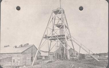
Postcard - POSTCARD. GREAT EXTENDERED HUSTLERS, 1865
Postcard. ROYAL HISTORICAL SOCIETY OF VICTORIA. Bendigo Branch Great Great Extended Hustlers. Locality. Hustlers Hill, Nth Bendigo Formed 1865 - Last production 1921 Depth of Shaft - 3470 feet Poppet Legs - Steel, 70 feet high Winding Engine: First motion 8ft. Drums. Golde Very Rich Total yield - 300,000 ozs. Dividends pounds 375,000 -
 Melbourne Tram Museum
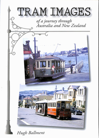
Book, Carl Segnit, Hugh Ballment, "Tram Images - of a journey through Australia and New Zealand", 2009
Book - 120 pages+ card cover + jacket, perfect bound, portrait format, titled "Tram Images - of a journey through Australia and New Zealand" by Hugh Ballment, published by Hugh Ballment. Has Hugh Ballment's signature on the title page. Design by Carl Segnit. Published 2009. Has a table of preface by Hugh and table of contents, listing the cities covered and topics and index of localities.trams, tramways, australian trams, new zealand tramways, melbourne, cable trams -
 Bendigo Historical Society Inc.
Document - NEW RED, WHITE & BLUE CONSOLIDATED MINE - NOTES ON THE NEW RED, WHITE & BLUE CONSOLIDATED MINE
One handwritten and five typed copies of notes on the New Red, White & Blue Consolidated Mine on the Sheepshead Line of Reef. Notes include locality, depth of shaft, plant, early history, leading mine, prominence, untimely end, gold production and a note referring to the poppet legs from the main shaft which were removed to the Central Deborah Mine. Albert Richardson Collectiondocument, gold, new red, white & blue consolidated, new red, white & blue consolidated mine, notes on the new red, white & blue consolidated mine, the union, new red white & blue mine, mr george lansell, central deborah mine, special edition australian mining standard 1/6/1899, mines dept booklet 'bendigo goldfield' 1936, mines dept annual and quarterly reports, annals of bendigo mining section 1889 - 1935 inclusinve, a richardson -
Glen Eira Historical Society
Plan - Ristori
Real Estate leaflet for the subdivision sale of the Ristori Estate & Residence on 31/05/1919 by Yeo, Crosthwaite & Co. A map of the 24 subdivisions available plus a locality plan are included along with details of separate sale on 04/06/1919 of the weatherboard buildings, rooms, stables & glass house.house names, 'ristori', land sales, sewerage, glen eira road, brick houses, land subdivision, orrong road, glasshouses, yeo crosthwaite & co melbourne, ripponlea, stables, ristori estate, auctions, drainage, liscard street, st. georges road, balaclava road, glen huntly road, glenhuntly road, elsternwick station, hotham street, weatherboard buildings, elsternwick -
 Bendigo Historical Society Inc.
Book - Geographical dictionary
The Gazetteer presents an extensive a to z list of Victorian towns and villages, lakes, rivers and creeks, islands, bays, hills and mountains, runs and other localities and features. Entries include latitude and longitude, populations, proximity to other towns, local industries, coach and mail runs, hotels, churches and schools.Bailliere's Victorian Gazetteer and road guide containing the most recent and accurate information as to every place in the colony. Brown hardcover book, on the spine: Victorian Gazetteer with map 1865. The first and last pages are advertisements. The book has 442 pages listing every place in the colony. The map is not included. Compiled by Robert P. Whitworth. Published by Bailliere, Regent Street Unreadable name on first page and the name of F. Houston in blue pen on first page geographic dictionary, colony of victoria -
Clunes Museum
Administrative record - BOOK, DEPARTMENT OF LANDS AND SURVEY, LICENCE
RECEIPTS ISSUED BY DEPARTMENT OF LANDS AND SURVEY TO CUT AND TAKE AWAY WOOD. ISSUED EACH QUARTER. LOCALITY - ALL CROWN LANDS, NOT BEING IN STATE FORESTS OR RESERVES FOR ANY SPECIAL PURPOSE. GUM, STRINGYBARK, BOX, MESSMATE AND OTHER KINDS OF EUCALYPTUS TIMBER EXCEPTING RED GUM AND IRON BARK.BLUE CARDBOARD COVERED BOOK CONTAINING TIMBER LICENCES FOR ORDINARY WOOD, COSTING 5/- .1 ISSUED 1886 - 1887 RECEIPT NUMBERS 181901 - 181925 .2 ISSUED 1885 - 1886 RECEIPT NUMBERS 185276 - 185300 DETAILS OF NAMES OF PERSONS LICENCES ISSUED TO ATTACHED TO BACK OF BOOKSlocal history, receipt books, early citizens, wood licences -
 Ringwood and District Historical Society
Flyer, Land Sale Advertisement - State School Estate, Ringwood, Victoria - 1923
The date of the flyer as circa 1920 can be estimated from the references to the (decision on) "electrification of the Croydon Railway Line" which eventually occurred in 1923, letting of tenders for the state school building which opened in 1924, and the "proposed new railway station" (East Ringwood) which opened in 1925, Advertisement for State School Estate, Ringwood - 26 residential allotments for sale near East Ringwood State School development site and 7 minutes walk from proposed new railway station (East Ringwood). Includes location map and terms of sale.Locality plan includes King Street and Government Roads (Later Everard Road, Holland Road, Purser Avenue, and Charles Street). (Agents) J.B. McAlpin, Estate Agent and Subdivisional Manager, Ringwood (Opposite Station), and F.V. Parker, Estate Agent, Main Street, Ringwood. -
![Mount St. George, Addis Bay / [by] Nicholas Caire, circa 1876](/media/collectors/550653872162f11fb04854aa/items/57833f9fd0cdd1176c6828f5/item-media/57833ffdd0cdd1176c685980/item-fit-380x285.jpg) Kew Historical Society Inc
Kew Historical Society IncPhotograph, Anglo-Australasian Photographic Company, Mount St. George, Addis Bay, c. 1876
Nicholas Caire was born on Guernsey in the Channel Islands in 1837. He arrived in Adelaide with his parents in about 1860. In 1867, following photographic journeys in Gippsland, he opened a studio in Adelaide. From 1870 to 1876 he lived and worked in Talbot in Central Victoria. In 1876 he purchased T. F. Chuck's studios in the Royal Arcade Melbourne. In 1885, following the introduction of dry plate photography, he began a series of landscape series, which were commercially successful. As a photographer, he travelled extensively through Victoria, photographing places few of his contemporaries had previously seen. He died in 1918. Reference: Jack Cato, 'Caire, Nicholas John (1837–1918)', Australian Dictionary of Biography.An original, rare photograph from the series 'Views of Victoria: General Series' by the photographer, Nicholas Caire (1837-1918). The 60 photographs that comprise the series were issued c. 1876 and reinforced a neo-Romantic view of the Australian landscape to which a growing nationalist movement would respond. Nicholas Caire was active as a photographer in Australia from 1858 until his death in 1918. His vision of the Australian bush and pioneer life had a counterpart in the works of Henry Lawson and other nationalist poets, authors and painters.‘Mount St. George, Addis Bay’ : Views of Victoria (General Series) No.56 : Albumen silver photograph | Photo on card with Title and Description on reverse | Mounted 24 x 30 cm; Photo 12 x 17 cm.On Reverse: ‘Addis Bay is situated to the north-east of Appollo Bay, and very near Cape Patten. This mountain is 6,000 feet high, and commands one of the finest views on the Cape Otway Ranges. The ascent is a somewhat difficult one, but visitors to this locality not unfrequently make this a favourite outing.’nicholas caire (1837-1918), landscape photography -
 University of Melbourne, Burnley Campus Archives
Plant specimen - Pressed Plant Collection, Mary Connors (née Lee), Burnley College student pressed and hand decorated plant collection of 13 Families, 1952-1953
Plant specimens collected and pressed by Mary Connors (née Lee) who graduated in 1953 with Certificate of Competency. Her daughter has rearranged the pages into 2 A4 lever arch ring binders. Collection depicting 13 families. 2 A4 Lever arch files with 25.5 x 20.5 cm plain paper sheets 1 pressed plant to a page arranged by families. Title page for each family with hand drawn and coloured examples. Specimens (faded) attached with cellotape. Some photocopied information sheets about certain families added after 1950's. Latin identification and Labels for 13 Plant families, Genus, Species, Common Name, Locality, Collector and Remarks. Some photocopied information sheets of plant families. A Proteaceae, Compositae, Leguminosae, Myrtaceae and B Orchidaceae, Graminaeae, Liliaceae, Amaryllidaceae, Iridaceae, Cruciferae, Rosaceae, Solanaceae, Scrophulariaceae plant specimen, mary connors (née lee), 1953, student assignments, burnley college, certificate of comptency -
 Federation University Historical Collection
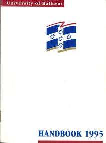
Book - Handbook, University of Ballarat Handbook, 1995, 1995
The University of Ballarat was formed in 1994, and is a predecessor organisation of Federation University Australia. White covered book with blue and maroon printing and logo. Information includes staff, admission policies and procedures, fees, Aboriginal and Torres Strait Islander Students, Scholarships, accomodation, International Students, courses, units, academic regulations, E.J. Barker Library Regulations, Appeals, Non-Sexist language, Student discipline, Academic Board Policy, Student Union, Enrolment, Parking, Campus plan, Locality map.university of ballarat handbook, courses, student association, marg thorne, mary rhyne, vicki anwyl, jenny geddes, wendy keyte, lynne billstone-convery, toni palmer, mary williams, steve blomeley, jenny gallagher, tracey fox -
Kew Historical Society Inc
Plan - Pointed Firs Estate, Camberwell North, 1936
Subdivision plans and real estate flyers/brochures reveal a number of aspects of urban development and history. The Kew Historical Society's collection of these plans, as well as advertisements extracted from magazines, cover key aspects of community development and architectural history of Kew and Kew Eat as well as surrounding suburbs. While most of the plans in the collection were gifted to the Society by the former City of Kew, a number of other plans and advertisements have been donated by individuals, of which this is an example.Original multi-page sales brochure of the Pointed Firs Estate, advertised as located in Camberwell North, but now in Balwyn North. The 4-page bifold brochure includes promotional material as well as a detailed plan of the 28 lots for sale, a photograph of the locality with the plan overlaying it, as well as aerial photos and street views. The estate included lots in Doncaster Road, Thackeray Street, Houghton Street, an dMaud Street. pointed firs estate -- balwyn north, subdivisions -- balwyn north (vic.) -
 Bendigo Historical Society Inc.
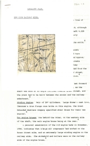
Document - ALBERT RICHARDSON COLLECTION: NEW CHUM RAILWAY MINE, GOLDEN SQUARE
Three-page typed document plus map. Document details location and history of the New Chum Railway Mine, Golden Square and includes: depth of shaft, size of lease, locality, poppet legs, winding engine, engine houses, crushing battery, best gold obtained, prominence, and total gold production and dividends. References provided. Document forms part of research referred to in Albert Richardson's paper 2264.70.bendigo, mining, new chum railway gold mine -
 Surrey Hills Historical Society Collection
Book, Marc Fiddian, Six stamps please: a tableau of Australian post offices, 1989
Once a community's size and importance could be gauged from its post office. The post office, especially in the 19th century, reflected the growth and prosperity of its locality. The boom in post office building was from the mid-1860s to the early 1890s. Invariably a post office was built in a prime location, frequently on a street corner.This book provides a cross section of the various styles of post offices built in city, suburb and country town, and who the post offices serve around Australia. Softback book of 83 pages, with numerous black and white photos; post offices are described alphabetically by town.surrey hills post office, post offices, official buildings, architectural styles, (mr) marc fiddian -
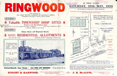 Ringwood and District Historical Society
Flyer, Township Shop Sites and Residential Allotments Sale By Public Auction, Ringwood, Victoria - 1926
Advertisement for eight township shop sites and five residential allotments for sale by Public Auction on the land in Ringwood on Saturday, 29th May, 1926, with location map, and summary of local features and services. Locality plan highlights sites for auction in Nelson Street, Seymour Street and Whitehorse Road. (Agents) Knight & Harwood, 315 Collins Street, Melbourne, Phones 10615, 10616 Central, in conjunction with J.B. McAlpin, Estate Agent, Opposite Railway Station, Ringwood, Phone Ringwood 7. -
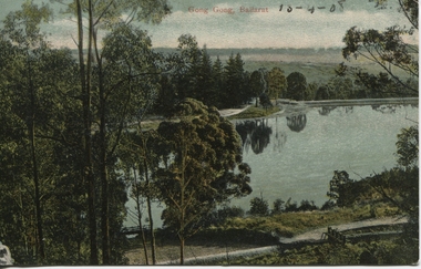 Ballarat Heritage Services
Photograph - Postcard, Gong Gong, Ballarat, 1908
Gong Gong was a locality in Ballarat East, near Fellmongers. A reservoir was built there. Situated only 10 minutes drive from the Ballarat CBD. In 2019 Gong Gong Reservoir Park is set in natural bush surrounds. There are scenics views, picnic and BBQ facilities with toilet facilities available on weekends. It is located along the Yarrowee River.photograph of Gong Gong reservoir 1908Gong Gong Ballarat - 13-4-1908 verso - note to Miss M I Wise, Gutheridge Parade, Salew. hewitt's yarrowee soap works, fellmongery, tannery, gong gong, mair street, daylesford road, o'deas, kinnane's, quin's, nestors