Showing 335 items
matching map box
-
 Whitehorse Historical Society Inc.
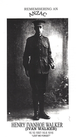
Article - School Project, Remembering an ANZAC, 1/06/1997 12:00:00 AM
Photocopy of Luther College Year 10 History assignment which describes several war memorials and researches the story of Henry Ivanhoe (Ivan) Walker whose name is on the Mitcham and Box Hill War Memorials.Photocopy of Luther College Year 10 History assignment which describes several war memorials and researches the story of Henry Ivanhoe (Ivan) Walker whose name is on the Mitcham and Box Hill War Memorials. He was killed by shellfire on the Western Front and his body never recovered. Copies of letters to and from his parents as they tried to find out information about his death are included. There is some information about his family and an interview with his sister Mrs Hazel Hall who provided some of his letters to his family. 65p Maps. Photographs.Photocopy of Luther College Year 10 History assignment which describes several war memorials and researches the story of Henry Ivanhoe (Ivan) Walker whose name is on the Mitcham and Box Hill War Memorials.walker, henry ivanhoe (ivan), walker family, war memorials, world war, 1914 - 1918 -
![Parish of Nunawading, County of Bourke showing land acquired under Closer Settlement Acts [C 1887]](/media/collectors/56f368632162f118acbff12e/items/60d923316e5f99545134f182/item-media/6147b12a4806c7ae686c24e4/item-fit-380x285.jpg) Whitehorse Historical Society Inc.
Whitehorse Historical Society Inc.Map, Parish of Nunawading, ca 1887
... Mitcham melbourne parish of nunawading box hill maps land ...Parish of Nunawading, County of Bourke showing land acquired under Closer Settlement Acts [C 1887]Parish of Nunawading, County of Bourke showing land acquired under Closer Settlement Acts [C 1887] 1947 reprint.Parish of Nunawading, County of Bourke showing land acquired under Closer Settlement Acts [C 1887] parish of nunawading, box hill, maps, land settlement -
 Whitehorse Historical Society Inc.
Pamphlet - Periodical, North East Link, 2018
Map and information regarding the proposed North East Link Project.Map and information regarding the proposed North East Link Project produced by the North East Link Authority. See Series Contents Box for holdings.Map and information regarding the proposed North East Link Project. north east link, map -
 Ballarat Heritage Services
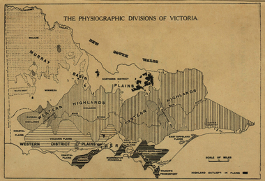
Map, Physiographic Divisions of Victoria, c1940, c1940
Physiographic map of Victoriavictoria, map, physiography -
 Ballarat Heritage Services
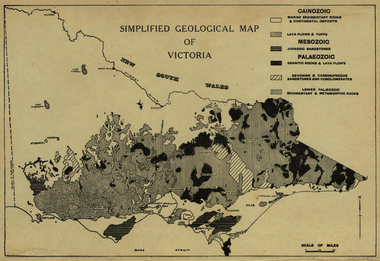
Map, Simplified Geological Map of Victoria, c1940, c1940
Physiographic map of Victoriavictoria, map, geology, geological -
Ballarat Heritage Services
Booklet, Rev. C.G. Schmidt, The Lutheran Church in Castlemaine also Yandoit and Maldon, c1986
Eighteen page booklet on the Lutheran church in and around Castlemaine. castlemaine, yandoit, maldon, lutheran church, pastor munzel, pastor leypoldt, german australians, map of castlemaine -
 Dandenong/Cranbourne RSL Sub Branch
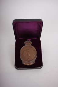
Medal - Medallion with original cardboard box, Unknown
WWI historic history.Bronze medallion presented to 2061 William Henry Elliott. Medallion is in commemoration of the men of ANZAC at GALLIPOLI in 1915 and in recognition of the great debt owed by all Australians. With the compliments of the Government of Australia. Medallion is round with a crown at the top.Cardboard box has typed address to Mrs L. Elliott, 59 Cleeland St, Dandenong from Central Army Records Office.W.H. Elliott. 1915 ANZAC. Simpson and his Donkey embossed at the back. Map of Australia and New Zealand with the stars of the Southern Cross embossed on the front. -
 Ballarat Heritage Services
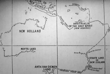
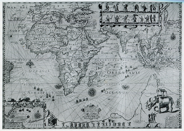
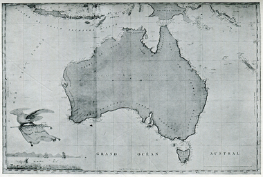
Photograph - Map, A Sketch from Dalyrmples Map of 1767, 1767
Copy of a map showing the coast that was known during the voyge of the Endeavour, and the first map that marks Torres track.map, new holland, hollandia nova, isaac de graaff, new guinea, australia of the holy spirit, papua, new hebrides, new zealand, nuyts land, van dieman's land, tasman's track, torres -
 Ballarat Heritage Services
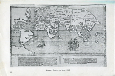
Photograph - Map, Robert Thorne's Map, 1527, 1527
This map serves the purpose of proving that Thorne and the Spanish geographers knew nothing about a continent near Australia.Copy of a map from 'A Short HIstory of Australia' by Ernest Scott.map, robert thorne, robert thorne's map, spanish explorers -
 Ballarat Heritage Services
Map, Map Published at Paris, 1587, 1527
This map shows a portion of New Guinea, but the plae occupied by Austrlai was left as open ocean.Copy of a map from 'A Short HIstory of Australia' by Ernest Scott.map, paris map, new guinea, early australian mapping -
 Ballarat Heritage Services
Map, Plancius's Map (Amsterdam), 1594, 1594
Copy of a Dutch map published in Amsterdam. showing a large stretch of outhern land called Terra sustralis Copy of a map from 'A Short HIstory of Australia' by Ernest Scott.map, plascius, placius's map, terra australis, dutch map -
 Ballarat Heritage Services
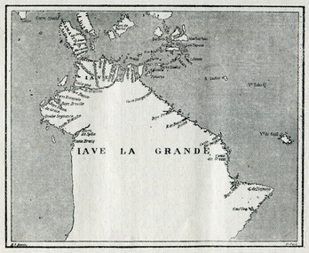
Map, Map of Java La Grande, 1542, 1542
Copy of a map from 'A Short HIstory of Australia' by Ernest Scott.map, chart of the southland, hessel gerritsz, dutch discovery of australiaj.e heres het aandael -
 Ballarat Heritage Services
Map, Map Illustrating Voyage of Ban Neck's Fleet to Dutch East Indies, 1598-1600, 1598-1600
Copy of a map from 'A Short HIstory of Australia' by Ernest Scott.map, van neck's fleet, dutch east indies -
 Ballarat Heritage Services
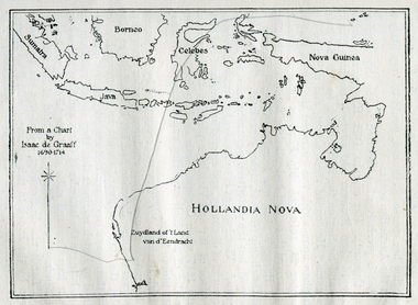
Photograph - Map, Map of New Holland from a chart by Isaac de Graaf (1690-1714), c1714
Copy of a map from 'A Short HIstory of Australia' by Ernest Scott.map, new holland, hollandia nova, isaac de graaff, new guinea, australia of the holy spirit, papua, new hebrides, new zealand, nuyts land, van dieman's land, tasman's track -
 Ballarat Heritage Services
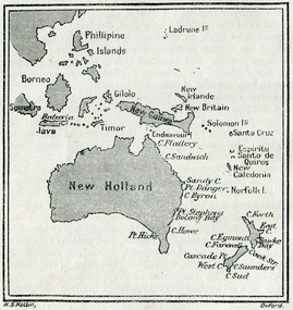
Map, New Holland and New South Wales as Known after Cook's Voyages
Copy of a map from 'A Short HIstory of Australia' by Ernest Scott.map, explorers, exploration, new holland, norfolk island, point hicks, timor -
 Ballarat Heritage Services
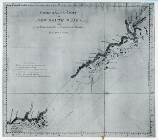
Photograph - Map, Portion of Captain James Cook's Chart of New South Wales, 1770, 1770
Copy of a map from 'A Short HIstory of Australia' by Ernest Scott.map, explorers, exploration, voyages, captain james cook, new south wales coast -
Ballarat Heritage Services
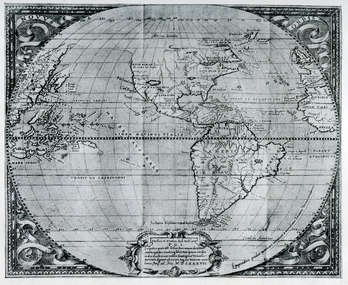
Map, Map of Abel Tasman's Voyages, 1642-1644
Copy of a map from 'A Short HIstory of Australia' by Ernest Scott.map, explorers, exploration, abel tasman, voyages -
 Ballarat Heritage Services
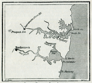
Map, Botany Bay and Port Jackson
Copy of a map from 'A Short HIstory of Australia' by Ernest Scott.map, explorers, exploration, voyages, new south wales coast, port jackson, botany bay bankstown, prospect hill, parramatta, rose hill, sydney -
 Ballarat Heritage Services
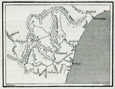
Map, The Blue Mountains, New South Wales
Copy of a map from 'A Short HIstory of Australia' by Ernest Scott.map, explorers, exploration, new south wales coast, parramatta, sydney, gosford, maitland, newcastle, blue mountains, picton -
 Ballarat Heritage Services
Photograph - Map, Freycinet's Map, Showing 'Terre Napoleon'
Copy of a map from 'A Short History of Australia' by Ernest Scott.map, explorers, exploration, freycinet, terre napoleon, australia -
 Ballarat Heritage Services
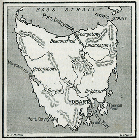
Photograph - Map, Hobart and Port Dalrymple
Copy of a map from 'A Short History of Australia' by Ernest Scott.map, explorers, exploration, bass straight, hobart, port davey, georgetown, beaconsfield, queenstown, gordon rover, derwent river, launceston, port dalrymple, banks straight, macquarie harbour, maps, plans -
 Ballarat Heritage Services
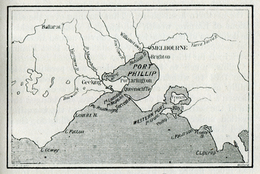
Map, Westernport and Port Phillip
Copy of a map from 'A Short History of Australia' by Ernest Scott.map, explorers, exploration, westernport, port phillip, queenscliffe, melbourne, brighton, williamstown, port arlington, hobson bay, cape otway, geelong, barwon river, ballarat, yarra river, yarra yarra river -
 Ballarat Heritage Services
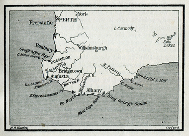
Map, King George's Sound
Copy of a map from 'A Short History of Australia' by Ernest Scott.map, explorers, exploration, king george's sound, perth, fremantle, bunbury, busselton, bridgetown, albany, york, williamsburgh -
 Ballarat Heritage Services
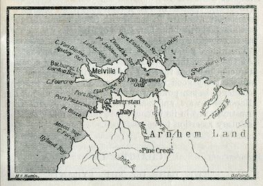
Map, Melville Island
Copy of a map from 'A Short History of Australia' by Ernest Scott.map, explorers, exploration, melville island, tiwi islands, arnhem land, palmerston, daly, croker island, bathurst island, pine creek, daly river -
 Ballarat Heritage Services
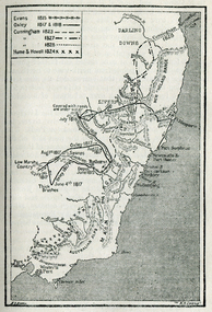
Map, Australian Inland Exploration, 1815-1928, 1815-1828
Copy of a map from 'A Short History of Australia' by Ernest Scott.map, explorers, exploration, australian alps, westernport, port phillip, hume and hovell, oxley, evans, cunningham, darling downs, liverpool -
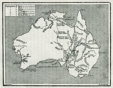 Ballarat Heritage Services
Map, Exploration of Eyre, Sturt, Stuart, Gregory, Burke, and Wills
Copy of a map from 'A Short History of Australia' by Ernest Scott.map, explorers, exploration, burke and wills, sturt, stuart, gregory, melbourne, perth, sydney, mitchell river, a.c. gregory, darling river, lachlan river, mt stuart, murray river -
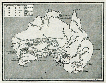 Ballarat Heritage Services
Map, Exploration of Eyre, Sturt, Stuart, Gregory, Burke, and Wills
Copy of a map from 'A Short History of Australia' by Ernest Scott.map, explorers, exploration, stuart, gregory, melbourne, perth, sydney, darling river, murray river, adelaide, albany, fitzroy river, flinders river, brisbane, great australian bight, gulf of carpentaria, mount grey, forrest -
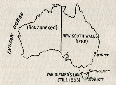 Ballarat Heritage Services
Map, Australian Colonies (States), c1918
Copy of a map from 'A Short History of Australia' by Ernest Scott published in 1918. map, australia, indian ocean, van dieman's land, tasmania, new south wales, sydney, western australia, perth, albany, launceston, hobart, south australia, melbourne, townsville, rockhampton, brisbane, northern territory, queensland -
 Ballarat Heritage Services
Map, Central Europe and the Mediterranean during World War One
Map of the World as it was during World War One. map of the world, world war one, france, spain, england, ireland, germany, austria-hungary, rumania, servia, albania, greece, bulgaria, russia, asia minor, turkey, egypt, tripoli, morocco, algeria, tunis -
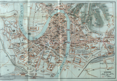 Ballarat Heritage Services
Map, Verona, 1924, 1924
Image of a map of Verona, Italy in 1924verona, italy, map