Showing 188 items
matching map of phillip island
-
 Victorian Aboriginal Corporation for Languages
Book, Melway Publishing, Melway Greater Melbourne street directory : including Geelong, Phillip Island, Healesville, Kinglake, Gisborne, Lorne, Wallan, Bacchus Marsh, Bellarine &? Mornington Peninsulas, 2005
Street directory including the wider area surrounding Melbourne.mapsmaps, victorian street maps, street directories, road maps -
 Victorian Aboriginal Corporation for Languages
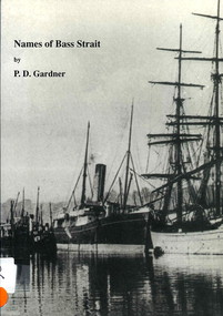
Book, P D Gardner, Names of Bass Strait : their origins, meanings and history, 1996
An examination of the origins of over 400 names in and around the Bass Strait, including Victorian areas from Cape Otway to Lakes Entrance and the north coast of Tasmania.Maps, b&w illustrations, b&w photographsbunerong, bass strait, tasmania, place names, bassian isthmus, king island, otway coast, port phillip bay, western port bay, wilsons promontory, cape barren island, flinders island, king island -
 Victorian Aboriginal Corporation for Languages
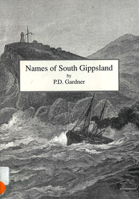
Book, P D Gardner, Names of South Gippsland : their origins, meanings and history, 1992
Provides an account of the origins and histories of local names in the South Gippsland region.Maps, b&w illustrations, b&w photographsbunerong, kulin, gunnai, kurnai, brataualung, seaspray, phillip island, mirboo, wilsons promontory, woodside, foster, inverloch, leongatha, wonthaggi -
Koorie Heritage Trust
Book, Pybus, Cassandra, Community of thieves, 1992
In 1892 Richard Pybus took up a large land grant on Bruny Island, the traditional home of the Nuenone people of south-east Tasmania. Within months of his arrival there were no Nuenone left on the island - they had either died from disease, or been murdered or exiled. Truganini, the last of the Nuenone, died in 1876, having spent her adult life in exile as a dependent of the colonial government. Describes sealers use of Tasmanian women and Robinson's Port Phillip expedition.xiv, 198 p., [2] leaves. : ill., maps & ports. ; references; appendix; 20 cm.In 1892 Richard Pybus took up a large land grant on Bruny Island, the traditional home of the Nuenone people of south-east Tasmania. Within months of his arrival there were no Nuenone left on the island - they had either died from disease, or been murdered or exiled. Truganini, the last of the Nuenone, died in 1876, having spent her adult life in exile as a dependent of the colonial government. Describes sealers use of Tasmanian women and Robinson's Port Phillip expedition.truganini, 1812?-1876. | aboriginal tasmanians -- tasmania -- bruny island -- history -- 19th century. | nuenone (australian people) -- tasmania -- bruny island -- history -- 19th century. -
 Kew Historical Society Inc
Book, Libraries Board of South Australia, An historical journal of the transactions at Port Jackson and Norfolk Island with the discoveries which have been made in New South Wales and in the southern ocean since the publication of Phillip's voyage, compiled from the official papers, including the journals of Governors Phillip and King and of Lieut. Ball, and the voyages from the first sailing of the Sirius in 1787, to the return of that ship's company to England in 1792, 1968
Facsimile of journals of the voyages from England to Port Jackson and Norfolk Island and return by Governors Phillip and King, and Lieut. Ball 1787-1792, including maps, charts, drawings and tables. Reproduced from a copy held in the State Library of South Australia originally published in 1793.583 p., <16> leaves of plates (2 folded) : ill., maps, 1 port. non-fictionFacsimile of journals of the voyages from England to Port Jackson and Norfolk Island and return by Governors Phillip and King, and Lieut. Ball 1787-1792, including maps, charts, drawings and tables. Reproduced from a copy held in the State Library of South Australia originally published in 1793.norfolk isalnd - history, port jackson, hunter, john (1737-1821) -
 Phillip Island Conservation Society Inc.
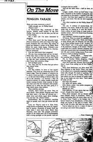
Work on paper - Photocopy of newspaper cutting, "On The Move/PENGUIN PARADE", circa 1960?
This article is written in a very conversational style with a number of asides and little 'digs' (e.g. Phillip Island being named after "Chap who first began to mess up Port Jackson".) The writer, Peter Fenton, is also relating some ornithological and tourist information, along with how to get to Phillip Island via the first Phillip Island bridge (so pre-1969) or train from Melbourne to Stony Point and across on ferry. The article is significant for demonstrating the growing interest in visiting destinations for natural experiences as well as activities such as golf and motor racing.photocopy of newspaper article cut from newspaper. double column of text with associated map below article. Dark patch from photocopy bottom right corner.15/3/65phillip island, little pengiuns, mutton birds, birds of the moon, pacific region, island rookeries, peter fenton, westernport ferry, stony point, railway line, first phillip island bridge, seal rocks, phillip island koalas, governor arthur phillip, golf links, motor racing course -
 Phillip Island Conservation Society Inc.
Work on paper - Photocopy of newspaper cutting, "PHILLIP ISLAND/A place to fall in love"
This article was written by an English visitor named Elsa Christian who was touring Australia and New Zealand with her husband Frank in their own small van. The article was published in the Australian Women’s Weekly, magazine, March 1966. Elsa writes she wanted to visit four Australian locations before she died: Ayers Rock (actually Uluru), the Snowy River project, dolphins at Coolangatta and the Penguin Parade at Phillip Island. These destinations were all very popular in the 1960s for both Australian residents and overseas visitors. Because the roads were becoming better too many locations, self guided tours in small vans for cars towing bond would caravans were becoming more popular means of seeing AustraliaThe article is significant in many ways. 1. Indicates the places English visitors commonly wish to see in Australia. 2. Describes the growing trend to self- drive van/camping holidays. 3. Gives the route taken from Melbourne to Phillip Island during the 1960s. 4. Describes the appearance of the roadsides and locations visited. 5. It is written in a descriptive and lyrical style designed to appeal to Women’s Weekly magazine readers, who were probably wondering how they could visit Phillip Island with their husbands or families themselves, and what there was to see there. 6. Gives the visitors’ view of how the Penguin Parade operated at the time. 7. Includes a description of potter and artist Eric Juckert’s renowned garden at Grossard Point, Ventnor. 8. Indicates how introduced plants such as Hawthorn pushes and Kate weed were common in the area. 9. Describes Phillip Island as “a place to fall in love” because of its natural beauty, fauna and coastal seascapes. 10. As a visitor Elsa describes the housing estates as a blot on the landscape, but also sees the value as a way of their owners escaping from the hustle and bustle of Melbourne. 11. Gives the visitors’ interpretation of the behaviour of wildlife the RC in the wild, as well as Elsa’s knowledge about some of the species she encounters.Photocopy of full page article with 5 columns of text, a map and 2 photographs. Black ink on white paper. Photographs blackened in photocopying processphillip island, cape woolamai, penguin parade, seal rocks, nobbies, township of rhyll phillip island, princes highway, dandenong, pakenham, kooweerup, carinya creek, officer, san remo, gippsland highway, holiday homes, fort dumaresq, kitty miller's beach, wreck of the speke, hereford cattle, fleetwood manor, koalas, ventnor, eric juckert, little penguin behaviour -
 Bendigo Military Museum
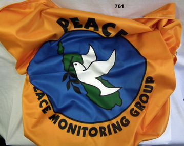
Flag - FLAG PEACE MONITORING, Screen Graphics, c.2000
The item was brought back from Peace Monitoring in Bougainville by Phillip Chapman Australian Army.Peace monitoring flag Bougainvillea, orange with white trim. A white dove holding black laurel branch on green Bougainvillea Island map, blue water in background. Peace Monitoring Groupflags, military, peace keeping force