Showing 270 items matching "mile creek"
-
 El Dorado Museum Association Inc.
Photograph - Digital Image
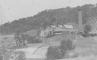
Cocks Pioneer Power Station No 1. Cocks Pioneer Electric Gold & Tin Mine Company was formed in 1899. The company's first power station, located at the eastern end of the valley began operating with its 340 Kilowatt steam-powered generator. By 1909, from 2 500 000 cubic yards worked, reported recovery was 17 284 ounces of gold and 224 tons of tin ore. By 1909, Cocks Pioneer’s power plant had become inadequate and uneconomical. The barge was floated downstream about a mile, but lost time caused the operations to cease. Following testing, a new mine was established by diverting Reid's Creek at a cost of £25 000. Settling dams were built, one of which held 1 935 900 cubic feet. Sold earth banks, built against a wall of stringy bark saplings constructed and laced with vertical props, were built. In 1914, the company was reformed as Cock’s Pioneer Gold and Tin Mines NL, another power station was constructed at the western end of the township, near the junction of Clear and Reid's Creeks. From 6,800,000 cubic yards of material processed, the returns were 64 397 ounces of gold and 855 ton of tin. Cocks Pioneer mine then moved the barge downs stream and continued sluicing. In 1929 Cocks Pioneer Electric Gold and Tin Mining Company ceased operations due to a drop in values. Cock’s Pioneer Gold and Tin Mines NL carried on large-scale hydraulic sluicing operations until 1941. Handrwitten on right side of image: PIONEER MINE ELDORADO Handwritten on left side of image: AJ EVANS PHOTO / WANGARATTAmines, mining, gold, tin, gold mining, tin mining, sluicing, hydraulic mining, energy, power station, cocks pioneer, el dorado, eldorado -
 El Dorado Museum Association Inc.
Photograph - Digital Image
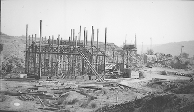
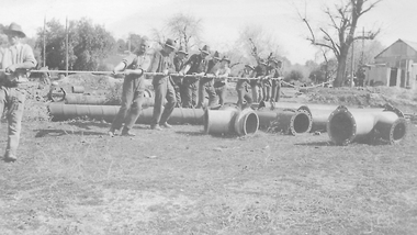
Construction of New Barge, Cocks Pioneer. Cocks Pioneer Electric Gold & Tin Mine Company was formed in 1899. The company's first power station, located at the eastern end of the valley began operating with its 340 Kilowatt steam-powered generator. By 1909, from 2,500,000 cubic yards worked, reported recovery was 17,284 ounces of gold and 224 tons of tin ore. By 1909, Cocks Pioneer’s power plant had become inadequate and uneconomical. The barge was floated downstream about a mile, but lost time caused the operations to cease. Following testing, a new mine was established by diverting Reid's Creek at a cost of £25 000. Settling dams were built, one of which held 1,935,900 cubic feet. Sold earth banks, built against a wall of stringy bark saplings constructed and laced with vertical props, were built. In 1914, the company was reformed as Cock’s Pioneer Gold and Tin Mines NL, another power station was constructed at the western end of the township, near the junction of Clear and Reid's Creeks. From 6,800,000 cubic yards of material processed, the returns were 64,397 ounces of gold and 855 ton of tin. Cocks Pioneer mine then moved the barge downs stream and continued sluicing. In 1929 Cocks Pioneer Electric Gold and Tin Mining Company ceased operations due to a drop in values. Cock’s Pioneer Gold and Tin Mines NL carried on large-scale hydraulic sluicing operations until 1941. mines, mining, gold, tin, gold mining, tin mining, sluicing, barge, construction, cocks pioneer, el dorado, eldorado -
 El Dorado Museum Association Inc.
Photograph - Digital Image
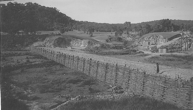
Creek Diversion, Cocks Power. Cocks Pioneer Electric Gold & Tin Mine Company was formed in 1899. The company's first power station, located at the eastern end of the valley began operating with its 340 Kilowatt steam-powered generator. By 1909, from 2 500 000 cubic yards worked, reported recovery was 17 284 ounces of gold and 224 tons of tin ore. By 1909, Cocks Pioneer’s power plant had become inadequate and uneconomical. The barge was floated downstream about a mile, but lost time caused the operations to cease. Following testing, a new mine was established by diverting Reid's Creek at a cost of £25 000. Settling dams were built, one of which held 1 935 900 cubic feet. Sold earth banks, built against a wall of stringy bark saplings constructed and laced with vertical props, were built. In 1914, the company was reformed as Cock’s Pioneer Gold and Tin Mines NL, another power station was constructed at the western end of the township, near the junction of Clear and Reid's Creeks. From 6,800,000 cubic yards of material processed, the returns were 64 397 ounces of gold and 855 ton of tin. Cocks Pioneer mine then moved the barge downs stream and continued sluicing. In 1929 Cocks Pioneer Electric Gold and Tin Mining Company ceased operations due to a drop in values. Cock’s Pioneer Gold and Tin Mines NL carried on large-scale hydraulic sluicing operations until 1941. mines, mining, gold, tin, gold mining, tin mining, creeks, cocks pioneer, el dorado, eldorado -
 El Dorado Museum Association Inc.
Photograph - Digital Image
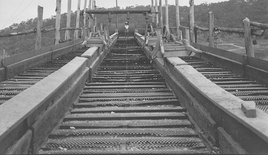
Riffle Boards on Barge, c1934. In sluicing, riffles are used to trap heavier gold particles as water washes over them. Cocks Pioneer Electric Gold & Tin Mine Company was formed in 1899. The company's first power station, located at the eastern end of the valley began operating with its 340 Kilowatt steam-powered generator. By 1909, from 2 500 000 cubic yards worked, reported recovery was 17 284 ounces of gold and 224 tons of tin ore. By 1909, Cocks Pioneer’s power plant had become inadequate and uneconomical. The barge was floated downstream about a mile, but lost time caused the operations to cease. Following testing, a new mine was established by diverting Reid's Creek at a cost of £25 000. Settling dams were built, one of which held 1 935 900 cubic feet. Sold earth banks, built against a wall of stringy bark saplings constructed and laced with vertical props, were built. In 1914, the company was reformed as Cock’s Pioneer Gold and Tin Mines NL, another power station was constructed at the western end of the township, near the junction of Clear and Reid's Creeks. From 6,800,000 cubic yards of material processed, the returns were 64 397 ounces of gold and 855 ton of tin. Cocks Pioneer mine then moved the barge downs stream and continued sluicing. In 1929 Cocks Pioneer Electric Gold and Tin Mining Company ceased operations due to a drop in values. Cock’s Pioneer Gold and Tin Mines NL carried on large-scale hydraulic sluicing operations until 1941. mines, mining, gold, gold mining, barge, riffles, sluicing, men, cocks pioneer, el dorado, eldorado -
 El Dorado Museum Association Inc.
Photograph - Digital Image
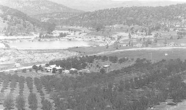
C Rankins Almond Orchard & Cocks Pioneer Pond, 1930s. Cocks Pioneer Electric Gold & Tin Mine Company was formed in 1899. The company's first power station, located at the eastern end of the valley began operating with its 340 Kilowatt steam-powered generator. By 1909, from 2 500 000 cubic yards worked, reported recovery was 17 284 ounces of gold and 224 tons of tin ore. By 1909, Cocks Pioneer’s power plant had become inadequate and uneconomical. The barge was floated downstream about a mile, but lost time caused the operations to cease. Following testing, a new mine was established by diverting Reid's Creek at a cost of £25 000. Settling dams were built, one of which held 1 935 900 cubic feet. Sold earth banks, built against a wall of stringy bark saplings constructed and laced with vertical props, were built. In 1914, the company was reformed as Cock’s Pioneer Gold and Tin Mines NL, another power station was constructed at the western end of the township, near the junction of Clear and Reid's Creeks. From 6,800,000 cubic yards of material processed, the returns were 64 397 ounces of gold and 855 ton of tin. Cocks Pioneer mine then moved the barge downs stream and continued sluicing. In 1929 Cocks Pioneer Electric Gold and Tin Mining Company ceased operations due to a drop in values. Cock’s Pioneer Gold and Tin Mines NL carried on large-scale hydraulic sluicing operations until 1941. mines, mining, farms, farming, almonds, sluicing, rankins, cocks pioneer, el dorado, eldorado -
 El Dorado Museum Association Inc.
Photograph - Digital Image
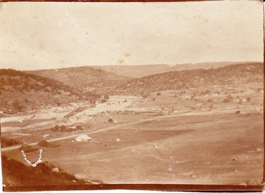
Cocks Pioneer, East El Dorado, early 1920s. Cocks Pioneer Electric Gold & Tin Mine Company was formed in 1899. The company's first power station, located at the eastern end of the valley began operating with its 340 Kilowatt steam-powered generator. By 1909, from 2 500 000 cubic yards worked, reported recovery was 17 284 ounces of gold and 224 tons of tin ore. By 1909, Cocks Pioneer’s power plant had become inadequate and uneconomical. The barge was floated downstream about a mile, but lost time caused the operations to cease. Following testing, a new mine was established by diverting Reid's Creek at a cost of £25 000. Settling dams were built, one of which held 1 935 900 cubic feet. Sold earth banks, built against a wall of stringy bark saplings constructed and laced with vertical props, were built. In 1914, the company was reformed as Cock’s Pioneer Gold and Tin Mines NL, another power station was constructed at the western end of the township, near the junction of Clear and Reid's Creeks. From 6,800,000 cubic yards of material processed, the returns were 64 397 ounces of gold and 855 ton of tin. Cocks Pioneer mine then moved the barge downs stream and continued sluicing. In 1929 Cocks Pioneer Electric Gold and Tin Mining Company ceased operations due to a drop in values. Cock’s Pioneer Gold and Tin Mines NL carried on large-scale hydraulic sluicing operations until 1941. mines, mining, gold, gold mining, cocks pioneer, sluicing, el dorado, eldorado -
 El Dorado Museum Association Inc.
Photograph - Digital Image
Moving Cocks Pioneer Barge, c1930s. Cocks Pioneer Electric Gold & Tin Mine Company was formed in 1899. The company's first power station, located at the eastern end of the valley began operating with its 340 Kilowatt steam-powered generator. By 1909, from 2,500,000 cubic yards worked, reported recovery was 17,284 ounces of gold and 224 tons of tin ore. By 1909, Cocks Pioneer’s power plant had become inadequate and uneconomical. The barge was floated downstream about a mile, but lost time caused the operations to cease. Following testing, a new mine was established by diverting Reid's Creek at a cost of £25,000. Settling dams were built, one of which held 1,935,900 cubic feet. Sold earth banks, built against a wall of stringy bark saplings constructed and laced with vertical props, were built. In 1914, the company was reformed as Cock’s Pioneer Gold and Tin Mines NL, another power station was constructed at the western end of the township, near the junction of Clear and Reid's Creeks. From 6,800,000 cubic yards of material processed, the returns were 64,397 ounces of gold and 855 ton of tin. Cocks Pioneer mine then moved the barge downs stream and continued sluicing. In 1929 Cocks Pioneer Electric Gold and Tin Mining Company ceased operations due to a drop in values. Cock’s Pioneer Gold and Tin Mines NL carried on large-scale hydraulic sluicing operations until 1941. mines, mining, gold, tin, gold mining, tin mining, men, miners, barge, sluicing, hydraulic, cocks pioneer, el dorado, eldorado -
 El Dorado Museum Association Inc.
Photograph (item) - Digital Image
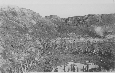
Cocks Pioneer old mine timbers. Cocks Pioneer Electric Gold & Tin Mine Company was formed in 1899. The company's first power station, located at the eastern end of the valley began operating with its 340 Kilowatt steam-powered generator. By 1909, from 2,500,000 cubic yards worked, reported recovery was 17,284 ounces of gold and 224 tons of tin ore. By 1909, Cocks Pioneer’s power plant had become inadequate and uneconomical. The barge was floated downstream about a mile, but lost time caused the operations to cease. Following testing, a new mine was established by diverting Reid's Creek at a cost of £25 000. Settling dams were built, one of which held 1,935,900 cubic feet. Sold earth banks, built against a wall of stringy bark saplings constructed and laced with vertical props, were built. In 1914, the company was reformed as Cock’s Pioneer Gold and Tin Mines NL, another power station was constructed at the western end of the township, near the junction of Clear and Reid's Creeks. From 6,800,000 cubic yards of material processed, the returns were 64,397 ounces of gold and 855 ton of tin. Cocks Pioneer mine then moved the barge downs stream and continued sluicing. In 1929 Cocks Pioneer Electric Gold and Tin Mining Company ceased operations due to a drop in values. Cock’s Pioneer Gold and Tin Mines NL carried on large-scale hydraulic sluicing operations until 1941. mining, gold, tin, open cut, gold mining, tin mining, cocks pioneer, el dorado, eldorado -
 Victorian Aboriginal Corporation for Languages
Book, A month in the bush of Australia : journal of one of a party of gentlemen who recently travelled from Sydney to Port Philip : with some remarks on the present state of the farming establishments and society in the settled parts of the Argyle Country, 1965
Journal of a party of gentlemen travelling from Sydney to Port Phillip; p.6-7; Information on Lakes Bathurst &? George; p.15; Family, Yass area gathering &? eating manna; p.20; Meeting with small tribe Mantons Station; p.23-24; Hume R., tribe, guide Baambargan; p.26; Meeting with native party 27 miles S.E. Ovens R.; p.30-32; Catching possum Violet Creek, Aboriginal - English, flies warn game of danger, finding honey; p.38; Visit to camp Campaspe R.; p.41-42; Yarrayarre R. natives seen, attempts by guide to obtain wife, language difficulties; p.46; Head of Wearidy R. camp visited by natives.7colonisation, frontier life, pioneer life -
 Sunshine and District Historical Society Incorporated
Photographs (1928), 'QUARTER MILE' BRIDGE Construction, 1928
One man lost his life during the building of this bridge. The bridge was constructed by the Victorian Railways between 1927 to 1929 to carry a new double track goods line. This enabled trains from all parts of the state except Gippsland to have direct access to the Tottenham marshalling and sorting yards. These yards were constructed in the 1920's to relieve congestion in the Melbourne Yard near Spencer Street station. The congestion was being caused by the construction of suburban passenger platforms associated with the electrification of the suburban railway network. Initially the bridge was for goods trains but during the Second World War it was also used by troop trains. When the standard gauge line was built in 1962 all trains to Albury and Sydney have used this route, thus avoiding travelling through Essendon and Pascoe Vale on the suburban tracks. The standard gauge track across the bridge took the place of one of the broad gauge tracks so broad gauge trains crossing the bridge in either direction have to now use the same track. The bridge is 1,257 feet (383.13 metres) long and 180 feet (54.86 metres) above the water level. It is just 63 feet (19.2 metres) short of a quarter mile in length between abutments. There is a similar bridge on the same railway line crossing the Moonee Ponds Creek between Gowenbrae and Glenroy, however it is smaller at 1060 feet (323.08 metres) length and 115 feet (35.05) height.The bridge is now Victorian Heritage Registered under Number: H1197, and Heritage Overlay Numbers HO5, and HO107. On the Heritage Register it is named RAIL BRIDGE (ALBION VIADUCT). According to the Heritage Report the bridge is scientifically and architecturally important because of its large size, and because of the cost effective design features such as two girders per span (one for each track), the K bracing in the towers, and the broad flange beams as columns. When it was being built it was the largest trestle bridge in Australia, and until the Sydney Harbour bridge was constructed it was the highest railway bridge.Five B&W yellowing photos showing stages of construction of the Maribyrnong River Viaduct known as the Trestle Bridge but mainly known locally as the QUARTER MILE BRIDGE. It is a railway only bridge which runs over the Maribyrnong River between Sunshine North and Keilor East. A sixth image, which is not part of this set of photos, is included to show what the completed bridge looks like. -
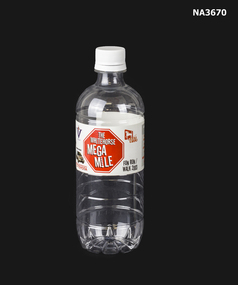 Whitehorse Historical Society Inc.
Souvenir - MEGAMILE WATER BOTTLE, circa 2003
The area between Springvale Road and Blackburn Road (along Whitehorse Road) Nunawading is defined as the 'Megamile. Well known for it's Homemaker stores.'Plastic water bottle inscribed with the words 'The Whitehorse Mega Mile Fun Run 2003'.domestic items, food & drink consumption -
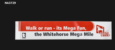 Whitehorse Historical Society Inc.
Souvenir - 'Mega Mile' Sticker, 2003
The first fun run (2003) was held to raise funds for Commonwealth Games athletes.Promotional sticker for the Whitehorse 'Mega Mile' fun rungovernment, local government / council -
Whitehorse Historical Society Inc.
Map, Ringwood, c1922
Victoria Ringwood Survey map 1 inch to 1 mile.Victoria Ringwood Survey map 1 inch to 1 mile. Covers Eastern suburbs of Melbourne from Richmond to Macclesfield, Heidelberg / Lilydale to Dandenong. Prepared by Commonwealth Section, Imperial General Staff.Victoria Ringwood Survey map 1 inch to 1 mile. eastern suburbs, melbourne, maps -
Whitehorse Historical Society Inc.
Article, Whatever Happened To, 24/12/1988 12:00:00 AM
Nunawading High School. Good Weekend - The Age Magazine.Nunawading High School. Good Weekend - The Age Magazine. Reunion of the Class of '64. With photos.Nunawading High School. Good Weekend - The Age Magazine. secondary schools, nunawading high school, hobba, jack, miles, david, bertuch, graeme, balding, graham, gemelli, lyn, edwards, lyn, harstad, leif, huddleston, terry, huddleston, julie, graham, julie, salopayeus, juris, rogers, nick, francis, jenny, breene, jenny, poulton, kayre, legrady, kayre, king, rosemary, galagher, rosemary, wordsworth, marjory, gogoll, marjory, hazell, dianne, stewart, dianne, everett, sue, davies, sue, troy, lyn, wills, lyn, scott, margaret, mcnaught, margaret, shera, lyn -
Whitehorse Historical Society Inc.
Map, City of Nunawading, n.d
Map of the City of Nunawading with streets and railway stations namedMap of the City of Nunawading with streets and railway stations named Scale 1 mile = 3.75 inMap of the City of Nunawading with streets and railway stations named city of nunawading, maps -
Whitehorse Historical Society Inc.
Map, City of Nunawading, c1980
Map of the City of Nunawading with list and location of 47 schools.Map of the City of Nunawading with list and location of 47 schools. Scale 1 mile = 3.75 inMap of the City of Nunawading with list and location of 47 schools. city of nunawading, maps, schools -
Whitehorse Historical Society Inc.
Article, Gold discovery at Mount Waverley, 1967
Article - In 1896 gold was discovered at Mount Waverley near the corner of Springvale Road and High Street Road.Article - In 1896 gold was discovered at Mount Waverley near the corner of Springvale Road and High Street Road. The discoverer, Mr P. Holland, sunk a shaft and the ground for miles was pegged out and prospectors were busy in the gullies searching for alluvial gold.Article - In 1896 gold was discovered at Mount Waverley near the corner of Springvale Road and High Street Road. mines and mining, high street road, glen waverley, springvale road, goldmining -
Whitehorse Historical Society Inc.
Map, Melbourne Geological Map, 1937
Geological Map of Melbourne & Suburbs.Geological Map of Melbourne & Suburbs. Scale: 40 chains to 1 inch with inset 10 miles to 1 inch. Includes Municipal and Parish boundaries, railways and stations, electric tramways, cable tramways, Post Offices and State schools. Area bounded by Braybrook, Preston, Blackburn & Brighton. Printed on linen.Geological Map of Melbourne & Suburbs. melbourne, maps -
Whitehorse Historical Society Inc.
Article, 30 Miles in 30 Months, 1964
Council announced that it will spend one and a half million pounds in 30 months on 30 miles of unmade streets in the City of Nunawading.Council announced that it will spend one and a half million pounds in 30 months on 30 miles of unmade streets in the City of Nunawading.Council announced that it will spend one and a half million pounds in 30 months on 30 miles of unmade streets in the City of Nunawading.city of nunawading, road construction -
Whitehorse Historical Society Inc.
Map, Sands and McDougall's Map of Melbourne & Suburbs, 1950s
Wall map of Melbourne and suburbs 12-18 mile radius of CBD.Wall map of Melbourne and suburbs 12-18 mile radius of CBD.Wall map of Melbourne and suburbs 12-18 mile radius of CBD.melbourne, maps -
Whitehorse Historical Society Inc.
Map, Ringwood, 1935
Australia Ringwood and area map.Australia1:63,360 series map, Ringwood N.849 Zone 7. Scale 1 inch to 1 mile. Approximate scope: Prahran-Cockatoo, Lilydale-DandenongAustralia Ringwood and area map.maps, ringwood -
Whitehorse Historical Society Inc.
Pamphlet - Newsletter, Urban design framework, 2010
City of Whitehorse Bulletin No.3 featuring a vision for Mega Mile (West) and the Blackburn Neighbourhood Activity Centre.City of Whitehorse Bulletin No.3 featuring a vision for Mega Mile (West) and the Blackburn Neighbourhood Activity Centre.City of Whitehorse Bulletin No.3 featuring a vision for Mega Mile (West) and the Blackburn Neighbourhood Activity Centre.blackburn neighbourhood activity centre, city of whitehorse, mega mile (west) -
Whitehorse Historical Society Inc.
Map, City of Nunawading, n.d
Map of the City of Nunawading with a list and locations of 48 schools.Map of the City of Nunawading with a list and locations of 48 schools. Scale: 1 mile = 3.75 inches.Map of the City of Nunawading with a list and locations of 48 schools. city of nunawading, schools -
Whitehorse Historical Society Inc.
Map, City of Nunawading, n.d
Map of the City of Nunawading with a list and locations of 49 schools.Map of the City of Nunawading with a list and locations of 49 schools. Scale: 1 mile = 3.75 inchesMap of the City of Nunawading with a list and locations of 49 schools. schools, city of nunawading -
Whitehorse Historical Society Inc.
Map, Nunawading District
Map of Blackburn, Mitcham and Nunawading District showing schools, public phones, police stations and post offices.Map of Blackburn, Mitcham and Nunawading District showing schools, public phones, police stations and post offices. Scale 20 chains to 1 mile.Map of Blackburn, Mitcham and Nunawading District showing schools, public phones, police stations and post offices. schools, mitcham, nunawading, police, post offices, blackburn, forest hill, vermont -
Whitehorse Historical Society Inc.
Article, Memorial move gets the vote, 2005
(a) Box Hill RSL will relocate its World War 1 and 2 memorials to the Box Hill Gardens precinct. (b) The Mega Mile Fun Run took place as a warm-up to the 2006 Commonwealth Games (photo).(a) Box Hill RSL will relocate its World War 1 and 2 memorials to the Box Hill Gardens precinct. (b) The Mega Mile Fun Run took place as a warm-up to the 2006 Commonwealth Games (photo).(a) Box Hill RSL will relocate its World War 1 and 2 memorials to the Box Hill Gardens precinct. (b) The Mega Mile Fun Run took place as a warm-up to the 2006 Commonwealth Games (photo).box hill returned servicemens league, box hill gardens, commonwealth games, festivals and celebrations, mega mile fun run -
Whitehorse Historical Society Inc.
Article, Why people travel miles, 17/11/1992 12:00:00 AM
Article by Liz Bell on George Greenberg and Peter Surrah's pharmacy, Mitcham Apothecary which he sold in 1992.Article by Liz Bell on George Greenberg and Peter Surrah's pharmacy, Mitcham Apothecary which he sold in 1992.Article by Liz Bell on George Greenberg and Peter Surrah's pharmacy, Mitcham Apothecary which he sold in 1992.greenberg, george, surrah, peter, pharmacies, mitcham apothecary -
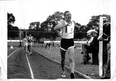 Whitehorse Historical Society Inc.
Photograph, Walk Championship, 1966
Photograph of 15th Victorian two mile walk championship in 1966. Won by Robert (Bob) Gardiner in 13 min 57.4 sec. Bob was a member of Collingwood Harriers Club. Cinder track replaced by synthetic track at Olympic Park, Swan Street, Melbourne Railway Building where Vodaphone Arena now located. Gardiner, Robert - No 1 Lucas, Alan - No 15- Coburg Harrier Henderson, Jim - No 6- University Athletic Club O'Dwyer, Jim - Finish Recorder| Olympic Parkgardiner, bob, lucas, alan, henderson, jim, o'dwyer, olympic park -
Whitehorse Historical Society Inc.
Document, Mitcham Amateur Cycling Club, 1938
Mitcham Amateur Cycling Club handicap events, 1 mile, 25 mile & 50 mile.Mitcham Amateur Cycling Club handicap events, 1 mile, 25 mile & 50 mile. Harold Starling was Honorary Handicapper and involved in Road Cycling Racing.Mitcham Amateur Cycling Club handicap events, 1 mile, 25 mile & 50 mile. mitcham amateur cycling club, startling, harold, cycling -
 Whitehorse Historical Society Inc.
Article, Freda Miles, 2018
... Whitehorse Historical Society Inc. 2-10 Deep Creek Road ...Freda Miles celebrated her 101st birthday at the Yes Op Shop Forest HillFreda Miles celebrated her 101st birthday at the Yes Op Shop Forest Hill where she has been a volunteer six days each week, for the last 8 years.Freda Miles celebrated her 101st birthday at the Yes Op Shop Forest Hillmiles, freda, yes op shop, forest hill